Bu fayl Vikianbarda yerləşir

Fayl:Byzantine Constantinople-tr.png

Vikipediya, azad ensiklopediya
Naviqasiyaya keç Axtarışa keç

Faylın orijinalı(3.075 × 2.775 piksel, fayl həcmi: 3,08 MB, MIME növü:image/png)

Vikipediya

This is a featured picture on the türk language Wikipedia (Seçkin resimler) and isconsideredone of the finest images.

If you think this file should be featured on Wikimedia Commons as well, feel free tonominate it.
If you have an image of similar quality that can be published under asuitable copyright license,be sure touploadit,tagit, andnominate it.

Xülasə

İzah
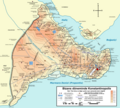
Deutsch:Topografische KarteKonstantinopel(heuteIstanbul) während des byzantinischen Zeitraums. Quelle: R. Janin,Constantinople Byzantine. Developpement urbain et repertoire topographique.Straßennetz und andere Einzelheiten basiert aufDumbarton Oaks Papers 54.Kirchen, insb. nicht identifizierte und ausgegrabene Bauten sind aus demThe Byzantine Churches of Istanbulentnommen. Andere herausgegebenen Quellen wurden behilfsmäßig gebraucht.
English:Topographical map ofConstantinople(present dayIstanbul) during theByzantineperiod. Main map source: R. Janin,Constantinople Byzantine. Developpement urbain et repertoire topographique.Road network and some other details based onDumbarton Oaks Papers 54;data on many churches, especially unidentified ones, taken from the University of New York'sThe Byzantine Churches of Istanbulproject. Other published maps and accounts of the city have been used for corroboration.
Türkçe:Konstantinopolis(bugünIstanbul)'in topografik haritası. Ana haritanın kaynağı: R. Janin,Constantinople Byzantine. Developpement urbain et repertoire topographique.Yol haritası ve bazı diğer ayrıntıların kaynağı:Dumbarton Oaks Papers 54;kiliseler, özellikle kimliği belirlenmemiş olanlar hakkında veriler, New York University'ninİstanbul'un Bizans Kiliseleriprojesinden elde edilmiştir. Şehir hakkında yayımlanmış diğer harita ve metinler bu bilgileri doğrulamak için kullanılmıştır.
Ελληνικά:Τοπογραφικός χάρτηςΚωνσταντινουπόλεως(σήμερα είναιΙστανμπούλ) κατά τη Βυζαντινή περίοδο. Βασική πηγή χάρτη: R. Janin,Constantinople Byzantine. Developpement urbain et repertoire topographique.Το οδικό δίκτυο και διάφορες άλλες λεπτομέρειες με βάση τοDumbarton Oaks Papers 54.Πληροφορίες για μη ταυτοποιημένες εκκλησίες από την ιστοσελίδαThe Byzantine Churches of Istanbulτου Πανεπιστημίου της Νέας Υόρκης.
Български:Топографска карта наКонстантинопол(днесИстанбул) през византийския период. Източник: R. Janin,Constantinople Byzantine. Developpement urbain et repertoire topographique.Пътната мрежа и някои други детайли се основават наDumbarton Oaks Papers 54и други публикувани източници.
Although I've striven to make this map as complete and correct as possible, there may be some errors or omissions. Any corrections & suggestions are welcome.
Tarix (UTC)
Mənbə
Müəllif
Digər versiyalar

[redaktə]

Full maps

SVG:

PNG:

Numeric versions

Regions

Roads


Butəsvirin redaktəsi,orijinala əsaslanaraq rəqəmsal qaydadadır. Dəyişiklik:converted to PNG format.İlkin təsvir buradadır:Byzantine Constantinople-tr.svg.Redaktə etdiİnfoCan.

I, the copyright holder of this work, hereby publish it under the following licenses:
w:az:Creative Commons
istinad verməkbənzər paylaşma
Bu faylCreative CommonsAttribution-Share Alike 3.0 Unportedlisenziyası altında yayımlanır.
Siz heç bir məhdudiyyət olmadan:
  • paylaşa bilərsiniz– əsəri köçürə, paylaya və ötürə bilərsiniz
  • remiks edə bilərsiniz– əsəri adaptasiya edə bilərsiniz
Aşağıdakı şərtlərə əməl etməklə:
  • istinad vermək– Müvafiq istinad verməli, lisenziyaya keçid əlavə etməli və dəyişikliklər edilib-edilmədiyini bildirməlisiniz. Siz bunu istənilən şəkildə edə bilərsiniz, lakin lisenziya verənin sizə şəxsən icazə verdiyini göstərən formada yox.
  • bənzər paylaşma– Əsəri remix edirsinizsə, dəyişdirirsinizsə və ya üzərində iş aparırsınızsa, öz töhfələrinizi orijinalda olduğu kimieyni və ya uyğun lisenziyaaltında yayımlamalısınız.
GNU head Bu sənədiGNU Azad Sənədləşdirmə Lisenziyası,Versiya 1.2 və yaAzad Proqram Fondutərəfindən nəşr olunan hər hansı sonrakı versiya şərtlərinə əsasən dəyişməz bölmələr, ön qapaq mətnləri və arxa qapaq mətnləri olmadan köçürmək, yayımlamaq və / və ya dəyişdirmək üçün icazə verilir; Lisenziyanın bir nüsxəsiGNU Azad Sənədləşdirmə Lisenziyasıadlı hissəyə daxil edilmişdir.
İstədiyiniz lisenziyanı seçə bilərsiniz.

Orijinal yükləmə gündəliyi

This image is a derivative work of the following images:

  • File:Byzantine_Constantinople_tr.svglicensed with Cc-by-sa-3.0, GFDL
    • 2010-06-28T18:40:55ZInfoCan2050x1850 (1724813 Bytes){{Information |Description={{en|1=Topographical map of [[Constantinople]] during the [[Byzantine Empire|Byzantine]] period. Main map source: R. Janin, ''Constantinople Byzantine. Developpement urbain et repertoire topographiq

Uploaded withderivativeFX

Captions

Add a one-line explanation of what this file represents

Items portrayed in this file

təsvir edir

media typeingilis

image/png

checksumingilis

2a8555295bb94f3d58e3e5f1388153f20ca0f261

data sizeingilis

3.228.747Bayt

3.075piksel

Faylın tarixçəsi

Faylın əvvəlki versiyasını görmək üçün gün/tarix bölməsindəki tarixlərə klikləyin.

Tarix/VaxtMiniatürÖlçülərİstifadəçiŞərh
hal-hazırkı19:53, 8 avqust 201019:53, 8 avqust 2010 tarixindəki versiyanın miniatür görüntüsü3.075 × 2.775(3,08 MB)İnfoCan{{Information |Description= |Source= |Date= |Author= |Permission= |other_versions= }}
00:26, 9 iyul 201000:26, 9 iyul 2010 tarixindəki versiyanın miniatür görüntüsü3.075 × 2.775(3,08 MB)InfoCan
00:24, 9 iyul 201000:24, 9 iyul 2010 tarixindəki versiyanın miniatür görüntüsü3.075 × 2.775(3,08 MB)InfoCan{{Information |Description= |Source= |Date= |Author= |Permission= |other_versions= }}
23:44, 8 iyul 201023:44, 8 iyul 2010 tarixindəki versiyanın miniatür görüntüsü3.075 × 2.775(3,08 MB)InfoCan{{Information |Description={{en|1=Topographical map ofConstantinopleduring theByzantineperiod. Main map source: R. Janin, ''Constantinople Byzantine. Developpement urbain et repertoire topographique''. Road network and some ot

Faylın qlobal istifadəsi