Follow these steps to get set up with the data-driven styling for datasets.
Get an API key and enable APIs
Before using the data-driven styling for datasets, you need: Cloud project with a billing account, and both the Maps JavaScript API and the Maps Datasets API enabled. To learn more, seeSet up your Google Cloud project.
Enable the Maps JavaScript API
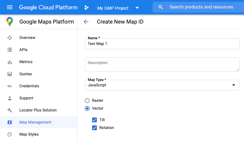
Create a map ID
To create a newmap ID,follow the steps in Cloud customization. Set the Map type toJavaScript,and select theVectoroption.
Provide a map ID using themapIdproperty when you instantiate the map.
The map ID must correspond to the map style that is associated with the dataset
to display.
constposition=newgoogle.maps.LatLng(40.75,-74.05);
constmap=newgoogle.maps.Map(document.getElementById('map'),{
zoom:11,
center:position,
mapId:'YOUR_MAP_ID',
});
Create a new map style
To create a new map style, follow the instructions inManage map styles to create the style, andassociate the style with the map ID you just created.
Update your map initialization code
To use the data-driven styling for datasets, first load the Maps JavaScript API,
by adding the inline bootstrap loader to your application code, as shown here
(usev=betain your APIscripttag):
<script>
(g=>{varh,a,k,p="The Google Maps JavaScript API",c="google",l="importLibrary",q="__ib__",m=document,b=window;b=b[c]||(b[c]={});vard=b.maps||(b.maps={}),r=newSet,e=newURLSearchParams,u=()=>h||(h=newPromise(async(f,n)=>{await(a=m.createElement("script"));e.set("libraries",[...r]+"");for(king)e.set(k.replace(/[A-Z]/g,t=>"_"+t[0].toLowerCase()),g[k]);e.set("callback",c+".maps."+q);a.src=`https://maps.${c}apis /maps/api/js?`+e;d[q]=f;a.onerror=()=>h=n(Error(p+"could not load."));a.nonce=m.querySelector("script[nonce]")?.nonce||"";m.head.append(a)}));d[l]?console.warn(p+"only loads once. Ignoring:",g):d[l]=(f,...n)=>r.add(f)&&u().then(()=>d[l](f,...n))})({
key:"YOUR_API_KEY",
v:"weekly",
// Use the 'v' parameter to indicate theversionto use (weekly, beta, Alpha, etc.).
// Add otherbootstrap parametersas needed, using camel case.
});
</script>
Check map capabilities (optional)
Data-driven styling for datasets requires a map ID. If the map ID is missing,
or an invalid map ID is passed, data features cannot load. As a
troubleshooting step, you can add amapcapabilities_changedlistener to
subscribe to map capability changes. This will indicate whether the following
conditions have been met:
- A valid map ID is in use.
- The map ID is associated with a vector map.
Using Map Capabilities is optional, and recommended only for testing and troubleshooting purposes, or for runtime fallback purposes.
// Optional: subscribe to map capability changes.
map.addListener('mapcapabilities_changed',()=>{
constmapCapabilities=map.getMapCapabilities();

if(!mapCapabilities.isDataDrivenStylingAvailable){
// Data-driven styling is *not* available, add a fallback.
// Existing feature layers are also unavailable.
}
});