Security notice:We have become aware of a security issue that may be affecting websites using specific third-party libraries (including polyfill.io). This issue can sometimes redirect visitors away from the intended website without website owner knowledge or permission. Many of our JavaScript samples previously included apolyfill.ioscript declaration. We have removed this from our samples. If you have used our JavaScript samples that contain this declaration, we recommend removing the declaration.
This page describes the client-side library available with
the Maps JavaScript API. If you want to work with the
Places API web service on your server, take a look at the
Node.js Client for Google Maps Services.The page at
that link also introduces the Java Client,
Python Client and Go Client for Google Maps Services.
Introduction
Autocomplete is a feature of the Places library in the
Maps JavaScript API. You can use autocomplete to give your
applications the type-ahead-search behavior of the Google Maps search field.
The autocomplete service can match on full words and substrings, resolving
place names, addresses, andplus
codes.Applications can therefore send queries as the user types, to
provide on-the-fly place predictions. As defined by the Places API,
a 'place' can be an establishment, a geographic location, or a prominent
point of interest.
Getting started
Before using the Places library in the Maps JavaScript API, first ensure
that the Places API is enabled in the Google Cloud Console, in the same
project you set up for the Maps JavaScript API.
Click theSelect a projectbutton, then select the same project you set up
for the Maps JavaScript API and clickOpen.
From the list of APIs on theDashboard,look for
Places API.
If you see the API in the list, you’re all set. If the API isnotlisted,
enable it:
At the top of the page, selectENABLE APIto display the
Librarytab. Alternatively, from the left side menu,
selectLibrary.
Search forPlaces API,then select it from the
results list.
SelectENABLE.When the process finishes,
Places APIappears in the list of APIs on the
Dashboard.
Loading the library
The Places service is a self-contained library, separate from the main
Maps JavaScript API code. To use the functionality contained
within this library, you must first load it using thelibraries
parameter in the Maps API bootstrap URL:
The API offers two types of autocomplete widgets, which you can add via
theAutocompleteandSearchBoxclasses respectively.
In addition, you can use theAutocompleteServiceclass to retrieve
autocomplete results programmatically (see the Maps JavaScript API Reference:
AutocompleteService class).
Below is a summary of the classes available:
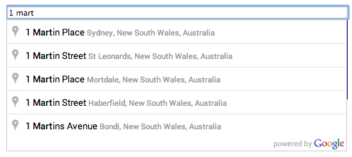
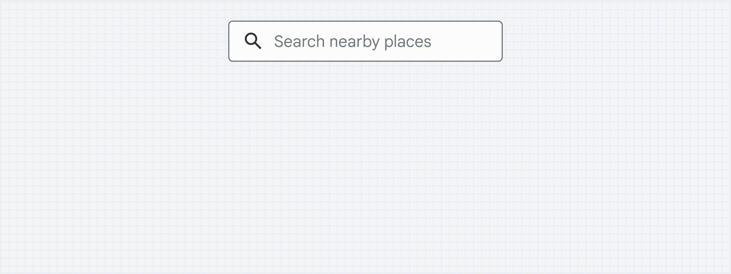
Autocompleteadds a text input field to your web page,
and monitors that field for character entries. As the user enters text,
autocomplete returns place predictions in the form of a
dropdown pick list. When the user selects a place from the list, information
about the place is returned to the autocomplete object, and can be retrieved
by your application. See the detailsbelow.
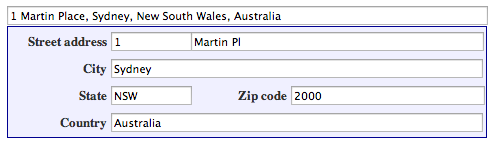
Figure 1: Autocomplete text field and pick listFigure 2: Completed address form
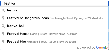
SearchBoxadds a text input field to your web page, in much
the same way asAutocomplete.The differences are as follows:
The main difference lies in the
results that appear in the pick list.SearchBoxsupplies
an extended list of predictions, which can include places (as defined by
the Places API) plus suggested search terms. For example, if the user
enters 'pizza in new', the pick list may include the phrase
'pizza in New York, NY' as well as the names of various pizza
outlets.
SearchBoxoffers fewer options than
Autocompletefor restricting the search. In the former, you
can bias the search towards a givenLatLngBounds.In the
latter, you can restrict the search to a particular country and particular
place types, as well as setting the bounds. For more information, see
below.
Figure 3: A SearchBox presents search terms and place predictions.
See the detailsbelow.
You can create an
AutocompleteServiceobject to retrieve
predictions programmatically. CallgetPlacePredictions()to
retrieve matching places, or callgetQueryPredictions()to
retrieve matching places plus suggested search terms.
Note:AutocompleteServicedoes not add any UI controls.
Instead, the above methods return an array of prediction objects. Each
prediction object contains the text of the prediction, as well as reference
information and details of how the result matches the user input. See the
detailsbelow.
Adding an Autocomplete widget
TheAutocomplete
widget creates a text input field on your web page, supplies predictions of places in a UI pick
list, and returns place details in response to agetPlace()request. Each entry in the
pick list corresponds to a single place (as defined by the Places API).
TheAutocompleteconstructor takes two arguments:
An HTMLinputelement of typetext.This is the input field that the autocomplete
service will monitor and attach its results to.
An optionalAutocompleteOptionsargument, which can
contain the following properties:
An array of datafieldsto be included in
thePlace Detailsresponse for the user's selectedPlaceResult.If the
property is not set or if['ALL']is passed in, all available fields are returned and
billed for(this is not recommended
for production deployments). For a list of fields, seePlaceResult.
An array oftypesthat
specifies an explicit type or a type collection, as listed in thesupported types.If no type is specified, all types are
returned.
boundsis agoogle.maps.LatLngBoundsobject specifying
the area in which to search for places. The results are biased towards, but not restricted to,
places contained within these bounds.
strictBoundsis aboolean
specifying whether the API must return only those places that are strictly within the region defined
by the givenbounds.The API does not return results outside this region even if they
match the user input.
componentRestrictionscan be used to restrict results to
specific groups. Currently, you can usecomponentRestrictionsto filter by up to 5
countries. Countries must be passed as as a two-character, ISO 3166-1 Alpha-2 compatible country
code. Multiple countries must be passed as a list of country codes.
Note:If you receive unexpected results with a country code, verify
that you are using a code which includes the countries, dependent territories, and special
areas of geographical interest you intend. You can find code information at
Wikipedia: List of ISO
3166 country codesor theISO Online Browsing
Platform.
placeIdOnlycan be used to instruct the
Autocompletewidget to retrieve only Place IDs. On calling
getPlace()on theAutocompleteobject, the
PlaceResultmade available will only have theplace id,
typesandnameproperties set. You can use the returned
place ID with calls to the Places, Geocoding, Directions or Distance Matrix
services.
Constraining Autocomplete predictions
By default, Place Autocomplete presents all place types, biased for predictions near the
user's location, and fetches all available data fields for the user's selected place. Set Place
Autocomplete options to present more relevant predictions based on
your use case.
Set options at construction
TheAutocompleteconstructor accepts anAutocompleteOptions
parameter to set constraints at widget creation. The following example sets the
bounds,componentRestrictions,andtypesoptions to
requestestablishmenttype places, favoring those within the specified geographic
area and restricting predictions to only places within the United States. Setting the
fieldsoption specifies what information to return about the user's selected place.
CallsetOptions()to change an option's value for an existing widget.
TypeScript
const center = { lat: 50.064192, lng: -130.605469 };
// Create a bounding box with sides ~10km away from the center point
const defaultBounds = {
north: center.lat + 0.1,
south: center.lat - 0.1,
east: center.lng + 0.1,
west: center.lng - 0.1,
};
const input = document.getElementById( "pac-input" ) as HTMLInputElement;
const options = {
bounds: defaultBounds,
componentRestrictions: { country: "us" },
fields: [ "address_components", "geometry", "icon", "name" ],
strictBounds: false,
};
const autocomplete = new google.maps.places.Autocomplete(input, options);
Specify data fields to avoid being billed forPlaces Data SKUsyou don't need. Include thefieldsproperty in the
AutocompleteOptionsthat are passed to the widget constructor, as demonstrated in the previous
example, or callsetFields()on an existingAutocompleteobject.
Use thetypesoption or callsetTypes()to constrain
predictions to certain place types. This constraint specifies a type or a type collection,
as listed inPlace Types.
If no constraint is specified, all types are returned.
For the value of thetypesoption or the value passed tosetTypes(),you
can specify either:
When a user selects a place from the predictions attached to the autocomplete
text field, the service fires aplace_changedevent. To get place
details:
Create an event handler for theplace_changedevent, and calladdListener()
on theAutocompleteobject to add the handler.
CallAutocomplete.getPlace()
on theAutocompleteobject, to retrieve aPlaceResult
object, which you can then use to get more information about the selected
place.
By default, when a user selects a place, autocomplete returns all of the
available data fields for the selected place, and you will bebilled accordingly.
UseAutocomplete.setFields()
to specify which place data fields to return. Read more about the
PlaceResultobject, including a list of place data fields that
you can request. To avoid paying for data that you don't need, be sure to useAutocomplete.setFields()to specify
only the place data that you will use.
Thenameproperty contains the
descriptionfrom Places Autocomplete predictions. You can read more about the
descriptionin the
Places
Autocomplete documentation.
For address forms, it is useful to get the address in structured format. To
return the structured address for the selected place, call
Autocomplete.setFields()
and specify theaddress_componentsfield.
The following example uses autocomplete to fill the fields in an address
form.
TypeScript
function fillInAddress() {
// Get the place details from the autocomplete object.
const place = autocomplete.getPlace();
let address1 = "";
let postcode = "";
// Get each component of the address from the place details,
// and then fill-in the corresponding field on the form.
// place.address_components are google.maps.GeocoderAddressComponent objects
// which are documented at http://goo.gle/3l5i5Mr
for (const component of place.address_components as google.maps.GeocoderAddressComponent[]) {
// @ts-ignore remove once typings fixed
const componentType = component.types[0];
switch (componentType) {
case "street_number": {
address1 = `${component.long_name} ${address1}`;
break;
}
case "route": {
address1 += component.short_name;
break;
}
case "postal_code": {
postcode = `${component.long_name}${postcode}`;
break;
}
case "postal_code_suffix": {
postcode = `${postcode}-${component.long_name}`;
break;
}
case "locality":
(document.querySelector( "#locality" ) as HTMLInputElement).value =
component.long_name;
break;
case "administrative_area_level_1": {
(document.querySelector( "#state" ) as HTMLInputElement).value =
component.short_name;
break;
}
case "country":
(document.querySelector( "#country" ) as HTMLInputElement).value =
component.long_name;
break;
}
}
address1Field.value = address1;
postalField.value = postcode;
// After filling the form with address components from the Autocomplete
// prediction, set cursor focus on the second address line to encourage
// entry of subpremise information such as apartment, unit, or floor number.
address2Field.focus();
}
function fillInAddress() {
// Get the place details from the autocomplete object.
const place = autocomplete.getPlace();
let address1 = "";
let postcode = "";
// Get each component of the address from the place details,
// and then fill-in the corresponding field on the form.
// place.address_components are google.maps.GeocoderAddressComponent objects
// which are documented at http://goo.gle/3l5i5Mr
for (const component of place.address_components) {
// @ts-ignore remove once typings fixed
const componentType = component.types[0];
switch (componentType) {
case "street_number": {
address1 = `${component.long_name} ${address1}`;
break;
}
case "route": {
address1 += component.short_name;
break;
}
case "postal_code": {
postcode = `${component.long_name}${postcode}`;
break;
}
case "postal_code_suffix": {
postcode = `${postcode}-${component.long_name}`;
break;
}
case "locality":
document.querySelector( "#locality" ).value = component.long_name;
break;
case "administrative_area_level_1": {
document.querySelector( "#state" ).value = component.short_name;
break;
}
case "country":
document.querySelector( "#country" ).value = component.long_name;
break;
}
}
address1Field.value = address1;
postalField.value = postcode;
// After filling the form with address components from the Autocomplete
// prediction, set cursor focus on the second address line to encourage
// entry of subpremise information such as apartment, unit, or floor number.
address2Field.focus();
}
window.initAutocomplete = initAutocomplete;
By default, the text field created by the autocomplete service contains
standard placeholder text. To modify the text, set the
placeholderattribute on theinputelement:
Note: The default placeholder text is localized automatically. If you
specify your own placeholder value, you must handle the localization of that
value in your application. For information on how the Google Maps
JavaScript API chooses the language to use, please read the documentation on
localization.
TheSearchBoxallows users to perform a text-based geographic
search, such as 'pizza in New York' or 'shoe stores near robson street'.
You can attach theSearchBoxto a text field and, as
text is entered, the service will return predictions in the
form of a drop-down pick list.
SearchBoxsupplies an extended list of predictions, which
can include places (as defined by the Places API) plus suggested search
terms. For example, if the user enters 'pizza in new', the pick list may
include the phrase 'pizza in New York, NY' as well as the names of various
pizza outlets. When a user selects a place from the list,
information about that place is returned to the SearchBox object, and can be
retrieved by your application.
TheSearchBoxconstructor takes two arguments:
An HTMLinputelement of typetext.This is
the input field that theSearchBoxservice will monitor and
attach its results to.
Anoptionsargument, which can contain the
boundsproperty:
boundsis agoogle.maps.LatLngBounds
object specifying the area in which to search for places. The results
are biased towards, but not restricted to, places contained within
these bounds.
The following code uses the bounds parameter to bias the results
towards places within a particular geographic area, specified via
laitude/longitude coordinates.
var defaultBounds = new google.maps.LatLngBounds(
new google.maps.LatLng(-33.8902, 151.1759),
new google.maps.LatLng(-33.8474, 151.2631));

var input = document.getElementById('searchTextField');

var searchBox = new google.maps.places.SearchBox(input, {
bounds: defaultBounds
});
Changing the search area for SearchBox
To change the search area for an existingSearchBox,call
setBounds()on theSearchBoxobject and pass the
relevantLatLngBoundsobject.
When the user selects an item from the predictions attached to the search
box, the service fires aplaces_changedevent. You can
callgetPlaces()on theSearchBoxobject, to
retrieve an array containing several predictions, each of which is a
PlaceResultobject.
For more information about thePlaceResultobject, refer to
the documentation on
place detail results.
TypeScript
// Listen for the event fired when the user selects a prediction and retrieve
// more details for that place.
searchBox.addListener( "places_changed", () => {
const places = searchBox.getPlaces();
if (places.length == 0) {
return;
}
// Clear out the old markers.
markers.forEach((marker) => {
marker.setMap(null);
});
markers = [];
// For each place, get the icon, name and location.
const bounds = new google.maps.LatLngBounds();
places.forEach((place) => {
if (!place.geometry ||!place.geometry.location) {
console.log( "Returned place contains no geometry" );
return;
}
const icon = {
url: place.icon as string,
size: new google.maps.Size(71, 71),
origin: new google.maps.Point(0, 0),
anchor: new google.maps.Point(17, 34),
scaledSize: new google.maps.Size(25, 25),
};
// Create a marker for each place.
markers.push(
new google.maps.Marker({
map,
icon,
title: place.name,
position: place.geometry.location,
})
);
if (place.geometry.viewport) {
// Only geocodes have viewport.
bounds.union(place.geometry.viewport);
} else {
bounds.extend(place.geometry.location);
}
});
map.fitBounds(bounds);
});
// Listen for the event fired when the user selects a prediction and retrieve
// more details for that place.
searchBox.addListener( "places_changed", () => {
const places = searchBox.getPlaces();
if (places.length == 0) {
return;
}
// Clear out the old markers.
markers.forEach((marker) => {
marker.setMap(null);
});
markers = [];
// For each place, get the icon, name and location.
const bounds = new google.maps.LatLngBounds();
places.forEach((place) => {
if (!place.geometry ||!place.geometry.location) {
console.log( "Returned place contains no geometry" );
return;
}
const icon = {
url: place.icon,
size: new google.maps.Size(71, 71),
origin: new google.maps.Point(0, 0),
anchor: new google.maps.Point(17, 34),
scaledSize: new google.maps.Size(25, 25),
};
// Create a marker for each place.
markers.push(
new google.maps.Marker({
map,
icon,
title: place.name,
position: place.geometry.location,
}),
);
if (place.geometry.viewport) {
// Only geocodes have viewport.
bounds.union(place.geometry.viewport);
} else {
bounds.extend(place.geometry.location);
}
});
map.fitBounds(bounds);
});
Programmatically retrieving Place Autocomplete Service predictions
To retrieve predictions programmatically, use the
AutocompleteServiceclass.AutocompleteService
does not add any UI controls. Instead, it returns an array of prediction
objects, each containing the text of the prediction, reference information,
and details of how the result matches the user input.
This is useful if you want more control over the user interface than is
offered by theAutocompleteandSearchBox
described above.
AutocompleteServiceexposes the following methods:
getPlacePredictions()returns place predictions.
Note: A 'place' can be an establishment, geographic location, or prominent
point of interest, as defined by the Places API.
getQueryPredictions()returns an extended list of
predictions, which can include places (as defined by the Places API)
plus suggested search terms. For example, if the user
enters 'pizza in new', the pick list may include the phrase
'pizza in New York, NY' as well as the names of various pizza outlets.
Both of the above methods return an array of
prediction
objectsof the following form:
descriptionis the matched prediction.
distance_metersis the distance in meters of the place from
the specifiedAutocompletionRequest.origin.
matched_substringscontains a set of substrings in the
description that match elements in the user's input. This is useful for
highlighting those substrings in your application. In many cases, the
query will appear as a substring of the description field.
lengthis the length of the substring.
offsetis the character offset, measured from the
beginning of the description string, at which the matched substring
appears.
place_idis a textual identifier that uniquely identifies
a place. To retrieve information about the place, pass this identifier in
theplaceIdfield of a
Place Details
request.Learn more about how to
reference a place
with a place ID.
termsis an array containing elements of the query. For
a place, each element will typically make up a portion of the address.
offsetis the character offset, measured from the
beginning of the description string, at which the matched substring
appears.
valueis the matching term.
The example below executes a query prediction request for the phrase
'pizza near' and displays the result in a list.
TypeScript
// This example retrieves autocomplete predictions programmatically from the
// autocomplete service, and displays them as an HTML list.
// This example requires the Places library. Include the libraries=places
// parameter when you first load the API. For example:
// <script src= "https://maps.googleapis /maps/api/js?key=YOUR_API_KEY&libraries=places" >
function initService(): void {
const displaySuggestions = function (
predictions: google.maps.places.QueryAutocompletePrediction[] | null,
status: google.maps.places.PlacesServiceStatus
) {
if (status!= google.maps.places.PlacesServiceStatus.OK ||!predictions) {
alert(status);
return;
}
predictions.forEach((prediction) => {
const li = document.createElement( "li" );
li.appendChild(document.createTextNode(prediction.description));
(document.getElementById( "results" ) as HTMLUListElement).appendChild(li);
});
};
const service = new google.maps.places.AutocompleteService();
service.getQueryPredictions({ input: "pizza near Syd" }, displaySuggestions);
}
declare global {
interface Window {
initService: () => void;
}
}
window.initService = initService;
// This example retrieves autocomplete predictions programmatically from the
// autocomplete service, and displays them as an HTML list.
// This example requires the Places library. Include the libraries=places
// parameter when you first load the API. For example:
// <script src= "https://maps.googleapis /maps/api/js?key=YOUR_API_KEY&libraries=places" >
function initService() {
const displaySuggestions = function (predictions, status) {
if (status!= google.maps.places.PlacesServiceStatus.OK ||!predictions) {
alert(status);
return;
}
predictions.forEach((prediction) => {
const li = document.createElement( "li" );
li.appendChild(document.createTextNode(prediction.description));
document.getElementById( "results" ).appendChild(li);
});
};
const service = new google.maps.places.AutocompleteService();
service.getQueryPredictions({ input: "pizza near Syd" }, displaySuggestions);
}
window.initService = initService;
<html>
<head>
<title>Retrieving Autocomplete Predictions</title>
<link rel= "stylesheet" type= "text/css" href= "./style.css" />
<script type= "module" src= "./index.js" ></script>
</head>
<body>
<p>Query suggestions for 'pizza near Syd':</p>
<ul id= "results" ></ul>
<!-- Replace Powered By Google image src with self hosted image. https://developers.google /maps/documentation/places/web-service/policies#other_attribution_requirements -->
<img
class= "powered-by-google"
src= "https://storage.googleapis /geo-devrel-public-buckets/powered_by_google_on_white.png"
alt= "Powered by Google"
/>
<!--
The `defer` attribute causes the script to execute after the full HTML
document has been parsed. For non-blocking uses, avoiding race conditions,
and consistent behavior across browsers, consider loading using Promises. See
https://developers.google /maps/documentation/javascript/load-maps-js-api
for more information.
-->
<script
src= "https://maps.googleapis /maps/api/js?key=AIzaSyB41DRUbKWJHPxaFjMAwdrzWzbVKartNGg&callback=initService&libraries=places&v=weekly"
defer
></script>
</body>
</html>
AutocompleteService.getPlacePredictions()
can use session tokens(if implemented)to group together autocomplete requests for billing
purposes. Session tokens group the query and selection phases of a user
autocomplete search into a discrete session for billing purposes. The session
begins when the user starts typing a query, and concludes when they select a
place. Each session can have multiple queries, followed by one place selection.
Once a session has concluded, the token is no longer valid. Your app must
generate a fresh token for each session. We recommend using session tokens for
all autocomplete sessions. If thesessionTokenparameter is
omitted, or if you reuse a session token, the session is charged as if no
session token was provided (each request is billed separately).
You can use the same session token to make a single
Place Details
request on the place that results from a call toAutocompleteService.getPlacePredictions().
In this case, the autocomplete request is combined with the Place Details
request, and the call is charged as a regular Place Details request. There is no charge for the
autocomplete request.
Be sure to pass a unique session token for each new session. Using the same token for more than
one Autocomplete session will invalidate those Autocomplete sessions, and all Autocomplete request
in the invalid sessions will be charged individually usingAutocomplete
Per Request SKU.Read more about session tokens.
The following example shows creating a session token, then passing it in an
AutocompleteService(thedisplaySuggestions()
function has been omitted for brevity):
// Create a new session token.
var sessionToken = new google.maps.places.AutocompleteSessionToken();

// Pass the token to the autocomplete service.
var autocompleteService = new google.maps.places.AutocompleteService();
autocompleteService.getPlacePredictions({
input: 'pizza near Syd',
sessionToken: sessionToken
},
displaySuggestions);
Be sure to pass a unique session token for each new session. Using the same
token for more than one session will result in each request being billed
individually.
By default, the UI elements provided byAutocompleteand
SearchBoxare styled for inclusion on a Google map. You may want
to adjust the styling to suit your own site. The following CSS classes are
available. All classes listed below apply to both the
Autocompleteand theSearchBoxwidgets.
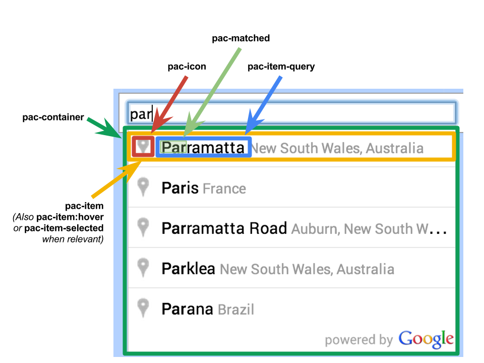
CSS classes for Autocomplete and SearchBox widgets
CSS class
Description
pac-container
The visual element containing the list of predictions returned by the
Place Autocomplete service. This list appears as a dropdown list below the
AutocompleteorSearchBoxwidget.
pac-icon
The icon displayed to the left of each item in the list of
predictions.
pac-item
An item in the list of predictions supplied by the
AutocompleteorSearchBoxwidget.
pac-item:hover
The item when the user hovers their mouse pointer over it.
pac-item-selected
The item when the user selects it via the keyboard. Note: Selected items
will be a member of this class and of thepac-itemclass.
pac-item-query
A span inside apac-itemthat is the main part of the
prediction. For geographic locations, this contains a place name, like
'Sydney', or a street name and number, like '10 King Street'. For
text-based searches such as 'pizza in New York', it contains the full text
of the query. By default, thepac-item-queryis colored
black. If there is any additional text in thepac-item,it is
outsidepac-item-queryand inherits its styling from
pac-item.It is colored gray by default. The additional text
is typically an address.
pac-matched
The part of the returned prediction that matches the user’s input. By
default, this matched text is highlighted in bold text. Note that the
matched text may be anywhere withinpac-item.It is not
necessarily part ofpac-item-query,and it could be partly
withinpac-item-queryas well as partly in the remaining text
inpac-item.
Use the Place Picker component
Note:This sample uses an open source library. See the
READMEfor support
and feedback related to the library.
Try web components. Use the
Place Picker web componentto enable text input that allows end users to search for a specific address or place using autocomplete.
Figure 1: Text input to search for a specific address or place using autocomplete
Place Autocomplete optimization
This section describes best practices to help you make the most of the
Place Autocomplete service.
Develop an understanding of essential Place Autocomplete
data fieldsfrom the start.
Location biasing and location restriction fields are optional but can
have a significant impact on autocomplete performance.
Use error handling to make sure your app degrades gracefully
if the API returns an error.
Make sure your app handles when there is no selection and offers users a way
to continue.
Cost optimization best practices
Basic cost optimization
To optimize the cost of using the Place Autocomplete
service, use field masks in Place Details and Place Autocomplete widgets to return only the
place data fieldsyou need.
Advanced cost optimization
Consider programmatic implementation of Place Autocomplete in order to accessPer Request pricingand requestGeocoding API resultsabout the selected place instead of Place Details. Per Request pricing paired with Geocoding API is more cost-effective than Per Session (session-based) pricing if both of the following conditions are met:
If you only need the latitude/longitude or address of the user's selected place, the Geocoding API delivers this information for less than a Place Details call.
If users select an autocomplete prediction within an average of four Autocomplete predictions requests or fewer, Per Request pricing may be more cost-effective than Per Session pricing.
For help selecting the Place Autocomplete implementation that fits your needs, select the tab that corresponds to your answer to the following question.
Does your application require any information other than the address and latitude/longitude of the selected prediction?
The following guidelines describe ways to optimize Place Autocomplete performance:
Add country restrictions,
location biasing,
and (for programmatic implementations) language preference to your Place Autocomplete
implementation. Language preference is not needed
with widgets since they pick language preferences from the user's browser or mobile device.
If Place Autocomplete is accompanied by a map, you can bias location by map viewport.
In situations when a user does not choose one of the Autocomplete predictions, generally
because none of those predictions are the desired result-address, you can re-use the original
user input to attempt to get more relevant results:
If you expect the user to enter only address information, re-use the original user input
in a call to theGeocoding API.
If you expect the user to enter queries for a specific place by name or address,
use aFind Place request.
If results are only expected in a specific region, use
location biasing.
Other scenarios when it's best to fall back to the Geocoding API include:
Users inputting subpremise addresses in countries where Place Autocomplete support of
subpremise addresses is incomplete, e.g. Czechia, Estonia and Lithuania. For example, the
Czech address "Stroupežnického 3191/17, Praha" yields a partial prediction in Place
Autocomplete.
Users inputting addresses with road-segment prefixes like "23-30 29th St, Queens" in
New York City or "47-380 Kamehameha Hwy, Kaneohe" on the island of Kauai in Hawai'i.