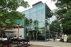
Daikanyamachō(Đại quan sơn đinh,Daikan'yama-chō),or simplyDaikanyama(Đại quan sơn),is a neighborhood inShibuya, Tokyo,Japan.The neighborhood is known for its small boutique shops, giving it the nickname "theBrooklynof Tokyo. "[2][3][4]It is served byDaikan-yama Stationon theTokyu Toyoko Line.
Daikanyamachō
Đại quan sơn đinh | |
|---|---|
 Daikanyama T-Site | |
 | |
| Country | |
| Prefecture | |
| Special ward | |
| Population (1 October 2020) | |
• Total | 2,078[1] |
| Time zone | UTC+09:00 |
| ZIP code | 150-0034 |
| Telephone area code | 03 |

Education
editShibuya Board of Educationoperates public elementary and junior high schools.
Elementary schools are zoned as follows:[5]
- Sarugaku Elementary School (Viên lặc tiểu học giáo): 1-12, most of 13 (except for two lots), 14-17, 18 (except for one lot), and 19-20-ban
- Nagayato Elementary School (Trường cốc hộ tiểu học giáo): two lots in 13-ban and one lot in 18-ban
All of Daikanyamacho is zoned to Hachiyama Junior High School (Bát sơn trung học giáo).[6]
Gallery
edit-
Backstreet in Daikanyama
-
Sidewalk cafein Daikanyama
-
Main road in Daikanyama as seen from a pedestrian bridge
-
Street scene, Daikanyama
References
edit- ^Trụ dân cơ bổn đài trướng ・ ngoại quốc nhân đăng lục による nhân khẩu.渋 cốc khu(in Japanese). Shibuya City.Retrieved18 October2020.
- ^Perhach, Paulette (21 November 2019)."On the Hunt in Tokyo for 'Authentic' Denim".The New York Times.Archivedfrom the original on 17 January 2020.Retrieved23 April2020.
- ^Hoofs, Irene (10 August 2014)."Daikanyama, Tokyo: The Hipster's Guide".Condé Nast Traveler.Condé Nast.Archivedfrom the original on 16 June 2019.Retrieved23 April2020.
- ^Betts, Nano (26 August 2017)."Daikanyama: A guide to Tokyo's Little Brooklyn".Japan Today.Archivedfrom the original on 16 February 2019.Retrieved23 April2020.
- ^"Học giáo biệt thông học khu vực ( tiểu học giáo )".City of Shibuya.Retrieved2022-10-08.- Has elementary zoning
- ^"Học giáo biệt thông học khu vực ( trung học giáo )".City of Shibuya.Retrieved2022-10-08.- Has junior high school zoning
35°39′6″N139°42′20″E/ 35.65167°N 139.70556°E