The Mauritania Portal - بوابة موريتانيا
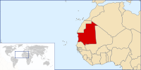
Mauritania,officially theIslamic Republic of Mauritania,is a sovereign country inNorthwest Africa.It is bordered by the Atlantic Ocean to the west,Western Saharatothe northand northwest,Algeriatothe northeast,Malitothe east and southeast,andSenegaltothe southwest.By land area Mauritania is the 11th-largest country in Africa and 28th-largest in the world; 90% of its territory is in theSahara.Most of its population of some 4.3 million lives in the temperate south of the country, with roughly a third concentrated in the capital and largest city,Nouakchott,on the Atlantic coast. The country's name derives from the ancientBerberkingdom ofMauretaniain North Africa within the ancientMaghreb.Berbers occupied what is now Mauritania beginning in the third century AD.Arabsunder theUmayyad Caliphateconquered the area in the late seventh century, bringing Islam, Arab culture, and the Arabic language. In the early 20th century, Mauritania wascolonized by Franceas part ofFrench West Africa.It achieved independence in 1960, but has since experienced recurrent coups and periods of military dictatorship. The most recent coup, in2008,was led by GeneralMohamed Ould Abdel Aziz,who won subsequent presidential elections in2009and2014.He was succeeded by GeneralMohamed Ould Ghazouanifollowing the2019 elections,which were considered Mauritania's firstpeaceful transition of powersince independence. Mauritania is culturally and politically part of theArab world;it is a member of theArab Leagueand Arabic is the official language. The official religion isIslam,and almost all inhabitants areSunni Muslims.Despite its prevailingArab identity,Mauritanian society is multiethnic; theBidhan,or so-called "white moors", make up 30% of the population, while theHaratin,or so-called "black moors", comprise 40%. Both groups reflect a fusion ofArab-Berberethnicity, language, and culture. The remaining 30% of the population comprises varioussub-Saharan ethnic groups. Despite an abundance of natural resources, including iron ore and petroleum, Mauritania remains poor; its economy is based primarily on agriculture, livestock, and fishing. Mauritania is generally seen as having a poorhuman rights record,and is particularly censured for the perpetuation ofslaveryas an institution within Mauritanian society, with an estimation by the 2018Global Slavery Indexof about 90,000 slaves in the country (or 2.1% of the population). (Full article...) Selected article - Hodh Ech Chargui(Arabic:ولاية الحوض الشرقي,romanized:Wilāyat al-Ḥawḍ al-Sharqī,lit. 'Eastern Basin Region') is a largeregionin easternMauritania,with an area of 182,700 km2.Its capital isNéma,but the largest town, inBassiknou Department,isFassala(or Vassale) at the extreme southeast of Mauritania, with 65,927 inhabitants at the 2013 census. The region borders the Mauritanian regions ofAdrar,TagantandHodh El Gharbito the west andMalito the east and south. TheAoukarbasin, which formerly gave name to a greater region, is located in the western part of Hodh Ech Chargui. As of 2013, the population of the region was 430,668, compared to 363,071 in 2011. There were 47.71 percent females and 52.29 percent males. As of 2008, the activity rate was 61.50 and economic dependency ratio was 1.11. As of 2008, the literacy rate for people aged 15 years and over was 53.90. The local government is headed by an elected district representative, while the elections for the local government are conducted every five years. Due to the political instability, the last elections were held in 2023. (Full article...)This is aGood article,an article that meets a core set of high editorial standards.
Ten Hamadi(Arabic:تن حمادي) orTenhemadis a village andrural communein southernMauritania,in theAïoun El Atroussdepartment of theHodh El Gharbiregion. In 2000, the commune had a population of 2,264, of which 155 lived in the village of Ten Hamadi itself, approximately 17 kilometres (11 mi) southwest of the main town and departmental capital of Aïoun El Atrouss. The population estimate in 2007 was 3,686, spread over 16 villages. The northern part of the commune is hilly but relatively favorable to agriculture, while the southern part is flat and characterized by sand dunes. Situated at the southern boundary of theSahara-Sahelregion of southern Mauritania, the climate is generally hot and dry. (Full article...)CategoriesGeneral images -The following are images from various Mauritania-related articles on Wikipedia.
Related portalsWikiProjects
Topics in MauritaniaCities and towns
CommunesAssociated WikimediaThe followingWikimedia Foundationsister projects provide more on this subject:
Discover Wikipedia usingportals | ||||||||||||||||||||||||||||||||||||||||||||||||||||||||||||||||


