Chiang Rai(Thai:เชียงราย,pronounced[tɕʰīaŋrāːj];Northern Thai:ᨩ᩠ᨿᨦᩁᩣ᩠ᨿเจียงฮาย,pronounced[tɕīaŋhāːj]) is one of Thailand's seventy-sixprovinces,which lies inupper northern Thailandand is Thailand's northernmost province. It is bordered by theShan StateofMyanmarto the north,Bokeo provinceofLaosto the east,Phayaoto the south,Lampangto the southwest, andChiang Maito the west. The provinces is linked toHouayxayLaos by theFourth Thai–Lao Friendship Bridgethat spans theMekong.
Chiang Rai
เชียงราย ᨩ᩠ᨿᨦᩁᩣ᩠ᨿ | |
|---|---|
| จังหวัดเชียงราย ·ᨧᩢ᩠ᨦᩉ᩠ᩅᩢᨯᨩ᩠ᨿᨦᩁᩣ᩠ᨿ | |
Left to right, top to bottom:KingMangraiIntersection, Chiang Rai Clock Tower,Wat Phra Kaew,Wat Phra Sing,Wat Rong Khun,Wat Rong Suea Ten,Doi Tung Royal Villa,Phu Chi Fa | |
 Flag  Seal | |
| Motto(s): "เหนือสุดในสยาม ชายแดนสามแผ่นดิน ถิ่นวัฒนธรรมล้านนา ล้ำค่าพระธาตุดอยตุง" ( "Northernmost of Siam,Border of three nations,Home ofLan Naculture. The precious Wat Phra That Doi Tung. ") | |
 | |
| Coordinates:19°54′N99°49′E/ 19.900°N 99.817°E | |
| Capital | Chiang Rai |
| Government | |
| • Governor | Charin Thongsuk |
| • PAO President | Adithathorn Wanchaithanawong |
| Area | |
• Total | 11,503 km2(4,441 sq mi) |
| • Rank | 12th |
| Population (2024)[2] | |
• Total | 1,297,657 |
| • Rank | 15th |
| • Density | 113/km2(290/sq mi) |
| • Rank | 44th |
| Human Achievement Index | |
| • HAI (2022) | 0.6307 "low" Ranked 52nd |
| GDP | |
| • Total | baht104 billion (US$3.6 billion) (2019) |
| Time zone | UTC+7(ICT) |
| Postal code | 57xxx |
| Calling code | 052 & 053 |
| ISO 3166 code | TH-57 |
| Vehicle registration | เชียงราย |
| Accession into Kingdom of Siam | 1910 |
| Accession into Kingdom of Thailand | 1932 |
| Website | www |


| Chiang Rai province | |
|---|---|
 | |
| Thai name | |
| Thai | เชียงราย |
| RTGS | Chiang Rai |
| Northern Thainame | |
| Northern Thai | ᨩ᩠ᨿᨦᩁᩣ᩠ᨿ [tɕiaŋ.haːj] |
Geography
editThe average elevation of the province is 580 metres (1,903 ft). The north of the province is part of the so-calledGolden Triangle,where the borders of Thailand, Laos and Burma converge, an area which prior to the rise of agricultural production of coffee, pineapple, coconuts, and banana plantations, was unsafe because of drugsmugglingacross the borders. TheMekongRiver forms the boundary with Laos, theMae SaiandRuak Riverwith Burma. Through the town ofChiang Raiitself, flows the "Mae Kok"Kok Riverand south of it theLao River,a tributary of the Kok.
While the eastern part of the province is characterized by relatively flat river plains, the northern and western part consists of the hilly terrain of theThai highlandswith theKhun Tan Rangeand thePhi Pan Nam Rangein the west and theDaen Lao Rangein the north. While not the highest elevation of the province, the 1,389-metre (4,557 ft) high[5]Doi Tung(Flag Hill) is the most important terrain feature.Wat Phra That Doi Chom Thongwaton top of the hill, according to the chronicles, dates back to the year 911. Nearby isDoi Tung Royal Villa,former residence of the late princess motherSomdej Phra Srinagarindra(mother ofKing Rama IX). Thanks to her activities the hills were reforested, and the hill tribes diverted from growing opium poppies to other crops including coffee, bananas, coconuts, and pineapples. The total forest area is 4,585 km2(1,770 sq mi) or 39.9 percent of provincial area.[1]
National parks
editThere are seven national parks, along with one other national park, make upregion 15of Thailand's protected areas.
- Doi Luang National Park,1,169 km2(451 sq mi)[6]: 61
- Lam Nam Kok National Park,587 km2(227 sq mi)[7]: 18
- Mae Puem National Park,351 km2(136 sq mi)[6]: 120
- Phu Sang National Park,285 km2(110 sq mi)[6]: 98
- Khun Chae National Park,270 km2(100 sq mi)[6]: 80
- Phu Chi Fa National Park,93 km2(36 sq mi)[7]: 21
- Tham Luang–Khun Nam Nang Non National Park,19 km2(7.3 sq mi)[7]: 7
History
editChiang Rai was founded in 1262. Populations have dwelled in Chiang Rai since the 7th century and it became the center of theLanna Kingdomduring the 13th century. The region, rich in natural resources, was occupied by the Burmese until 1786.
Chiang Rai province's golden triangle bordering Laos and Burma was once the hub of opium production.
Chiang Rai became a province in 1910, after being part of theLannaKingdom for centuries. After Lanna was incorporated into Thailand, it remained an autonomous region and thus the Chiang Rai area was administered from Chiang Mai.
Chiang Rai province is a transit point for Rohingya refugees from Myanmar (Burma) who are transported there from Sangkhlaburi district inKanchanaburi province.[8]
In September 2014, there was a major flood in Chiang Rai province, affecting six districts. It was the most severe flood in 50 years.[9]
Demographics
editThe majority of the population are ethnicThaiwho speakKham Muangamong themselves, but 12.5% are ofhill tribesorigin, a sizeable minority in the north provinces. A smaller number are ofChinesedescent, mainly descendants of theKuomintangsoldiers who settled in the region, notably inSantikhiri.
Ethnic groups
edit
Khon Muangare the city folk who originally came from Chiang Mai, Lamphun, Lampang, and Phrae. Culturally, they design their houses having only one floor with wooden gable decorations called "ka-lae". They are known for their craftsmanship in wood carving, weaving, lacquer ware, and musical instruments.
Tai Yai(ไทใหญ่) (Shan) are aTaiethnic group who primarily live in what is nowShan Statein Burma, and also inMae Hong Son provincein Thailand. They grow rice, farm, raise cattle, and trade. Their craftsmanship lies in weaving, pottery, wood carving, and bronze ware.
Akhahave the largest population of any hill tribe in the region. Originating from Tibet and southern China, they dwell on high ground around 1,200 meters above sea level. Within their villages they build spirit gateways to protect them from evil spirits.
Lahu(Musor) are also from the Yunnanese area and live in high areas. They are known as hunters and planters. Karenlive in various areas of the region which have valleys and riverbanks.
Chin Hawin Chiang Rai consist primarily of the formerKuomintang(KMT army) who took refuge in the area, mainly inSantikhiri(formerly Mae Salong).
Hmongfrom southern China, inhabit high ground. They raise livestock and grow rice, corn, tobacco, and cabbage. They are also known for their embroidery and silver.
Tai Lue(Dai) live in dwellings of usually only a single room wooden house built on high poles. They are skilled in weaving.
Lisufrom southern China and Tibet are renowned for their colorful dress and also build their dwellings on high stilts. They harvest rice and corn and their men are skilled in hunting.
Yao(Mien) reside along mountain sides and grow corn and other crops. They are skilled blacksmiths, silversmiths, and embroiders.

Symbols
edit

Theseal of the provinceshows awhite elephant,the royal symbol, recalling that Chiang Rai was founded by KingMengrai,according to legend because his elephant liked the place.
Theprovincial treeis the tree jasmine (Radermachera ignea), and the provincial flower is the orange trumpet (Pyrostegia venusta). Thegiant catfish(Pangasianodon gigas) is the provincial aquatic life.
The former provincial slogan was "เหนือสุดในสยาม อร่ามดอยตุง ผดุงวัฒนธรรม รสล้ำข้าวสาร หอมหวานลิ้นจี่ สตรีโสภา ชาเลิศรส สัปปะรดนางแล", 'Northernmost of Siam, beautifulDoi Tung,repository of culture, most delicious rice, sweet and fragrantlychee,beautiful women, the finest flavoured tea, pineapple fromNang Lae,source of thegiant catfish".
The current slogan is "เหนือสุดในสยาม ชายแดนสามแผ่นดิน ถิ่นวัฒนธรรมล้านนา ล้ำค่าพระธาตุดอยตุง", 'Northernmost of Siam, frontier of three lands, the home ofLan Naculture and Doi Tung Temple'.
Hospitals
edit- Kasemrad Sriburin General Hospital,Private hospital.
- Chiangrai Prachanukroh Hospital,Public hospital.
Tourism
editChiang Rai is recognised for its diverse landscapes, cultural heritage, and historical significance. The city is frequently visited by those interested in exploring its temples, markets, museums, and natural surroundings.[10][non-primary source needed]
One of the most popular attractions is theWat Rong Khun.[11]Another attraction is theGolden Triangle,which is the meeting point of Thailand, Laos, and Myanmar and offers views of the Mekong River and the surrounding mountains. Other popular attractions in Chiang Rai include theDoi Tung Royal Villa,Baan Dam Museum,the Hill Tribe Museum and Education Center, and the Khun Korn Waterfall.[12]
Chiang Rai is also a popular base for exploring the surrounding areas, including theMae Saiborder town, theChiang Saenhistorical city, and theDoi Mae Salongtea plantations.[citation needed]
Transport
edit
Air
editChiang Rai International Airporthas domestic flights to both Bangkok airports, which connect to regional and international flights.
Boat
editThere is daily boat service between Chiang Rai andTha Ton.
Rail
editThere is no railway system in Chiang Rai. The nearest station isChiang Mai Railway Station.
Road
editChiang Rai province is intersected byAsian Highway 2,which runs for over 13,000 kilometres (8,100 mi) fromDenpasarinIndonesiatoKosraviinIran,and byAsian Highway 3,which runs for over 7,000 km (4,300 mi) fromKentungin Myanmar toUlan-Udein Russia.
Decent bus services are available in the province. In more remote areas,songthaewsare the norm.
Administrative divisions
edit
Provincial government
editChiang Rai is divided into 18 districts (amphoes). The districts are further divided into 124 sub-districts (tambons) and 1,751 villages (mubans).
|
|
Local government
editAs of 26 November 2019 there are:[13]one Chiang Rai Provincial Administration Organisation (ongkan borihan suan changwat) and 73 municipal (thesaban) areas in the province. Chiang Rai has city (thesaban nakhon) status. Further 72 subdistrict municipalities (thesaban tambon). The non-municipal areas are administered by 70 Subdistrict Administrative Organisations - SAO (ongkan borihan suan tambon).
Human achievement index 2022
edit| Health | Education | Employment | Income |
| 61 | 71 | 53 | 19 |
| Housing | Family | Transport | Participation |

|
 |

|

|
| 42 | 37 | 45 | 20 |
| Province Chiang Rai, with an HAI 2022 value of 0.6307 is "somewhat low", occupies place 52 in the ranking. | |||
Since 2003, United Nations Development Programme (UNDP) in Thailand has tracked progress on human development at sub-national level using theHuman achievement index(HAI), a composite index covering all the eight key areas of human development. National Economic and Social Development Board (NESDB) has taken over this task since 2017.[3]
| Rank | Classification |
| 1–13 | "High" |
| 14–29 | "Somewhat high" |
| 30–45 | "Average" |
| 46–61 | "Somewhat low" |
| 62–77 | "Low" |
| Map with provinces and HAI 2022 rankings |

|
Gallery
edit-

-
 Pu Kaeng Waterfall,Doi Luang National Park
 -
 Huai Mak Liam Hot Spring,Lam Nam Kok National Park
 -
 A road tunnel decorated with Thai style art
 -
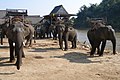 Elephants, Kok River
 -
 Kok River
 -
 Chiang Saen, Mekong River
 -
 Chiang Saen


References
edit- ^ab"Table 2 Forest area Separate province year 2019".Royal Forest Department.Retrieved6 April2021.
- ^"Official statistics registration systems".Department of Provincial Administration (DOPA).Retrieved10 February2025,year 2024 >provincial level >Excel File >no.57
{{cite web}}:CS1 maint: postscript (link) - ^ab"ข้อมูลสถิติดัชนีความก้าวหน้าของคน ปี 2565 (PDF)"[Human Achievement Index Databook year 2022 (PDF)]. Office of the National Economic and Social Development Council (NESDC) (in Thai).Retrieved12 March2024,page 26
{{cite web}}:CS1 maint: postscript (link) - ^"Gross Regional and Provincial Product, 2019 Edition".<>.Office of the National Economic and Social Development Council (NESDC). July 2019.ISSN1686-0799.Retrieved22 January2020.
- ^"Thailand - Mountains beginning with Doi Tung - Doi Tung to Doi Wiang Pha".www.indexmundi.com.
- ^abcd"ข้อมูลพื้นที่อุทยานแห่งชาติ ที่ประกาศในราชกิจจานุบกษา 133 แห่ง"[National Park Area Information published in the 133 Government Gazettes]. Department of National Parks, Wildlife and Plant Conservation (in Thai). December 2020. Archived fromthe originalon 3 November 2022.Retrieved1 November2022.
- ^abc"ข้อมูลพื้นที่อุทยานแห่งชาติ (เตรียมการ) 22 แห่ง"[Information of 22 National Parks Areas (Preparation)]. Department of National Parks, Wildlife and Plant Conservation (in Thai). December 2020. Archived fromthe originalon 3 November 2022.Retrieved1 November2022.
- ^"Putrajaya's migrant deluge woes", The Star, Kuala Lumpur, Malaysia, 13 May 2015,http://www.thestar.com.my/News/Nation/2015/05/13/Putrajayas-migrant-deluge-woes-Emergency-meetings-held-to-find-solutions/
- ^"Floodwaters Surge into Chiang Rai City Center".MCOT.24 November 2024.Retrieved12 September2024.
- ^"The official website of Tourism Authority of Thailand".www.tourismthailand.org.Retrieved10 May2023.
- ^Barnes, Jo (16 December 2022)."Top 10 Very Best Things to Do in Chiang Rai, Thailand".Your Lifestyle Business.Retrieved10 May2023.
- ^Berger, Arthur Asa (18 March 2014).Thailand Tourism.Routledge.ISBN978-1-317-82478-7.
- ^"Number of local government organizations by province".dla.go.th.Department of Local Administration (DLA). 26 November 2019.Retrieved10 December2019.
12 Chiang Rai: 1 PAO, 1 City mun., 72 Subdistrict mun., 70 SAO.
External links
edit Chiang Raitravel guide from Wikivoyage
- Provincial Website(Thai)
- Chiang Rai page from the Tourist Authority of Thailand
Religion
edit- Buddhism90.81 (90.6%)
- Christianity8.82 (8.80%)
- Islam0.27 (0.27%)
- Hinduism0.04 (0.04%)
- Confucianism0.02 (0.02%)
- Sikhism0.1 (0.10%)
- Not Religious 0.2 (0.20%)
- Unknown 0.01 (0.01%)
- Other 0.01 (0.01%)