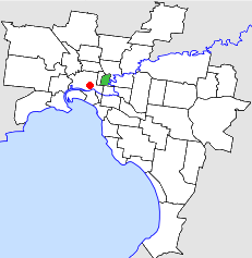
TheCity of Collingwoodwas alocal government areaabout 3 kilometres (2 mi) east-northeast ofMelbourne,the state capital ofVictoria,Australia.The city covered an area of 4.48 square kilometres (1.73 sq mi), and existed from 1855 until 1994.
| City of Collingwood Victoria | |||||||||||||||
|---|---|---|---|---|---|---|---|---|---|---|---|---|---|---|---|
 Location inMelbourne | |||||||||||||||
| Population | 14,000 (1992)[1] | ||||||||||||||
| • Density | 3,130/km2(8,090/sq mi) | ||||||||||||||
| Established | 1855 | ||||||||||||||
| Area | 4.48 km2(1.7 sq mi) | ||||||||||||||
| Council seat | Collingwood | ||||||||||||||
| Region | InnerMelbourne | ||||||||||||||
| County | Bourke | ||||||||||||||
 | |||||||||||||||
History
editCollingwood was first incorporated as a district on 24 April 1855, having split from theCity of Melbourneon the same day as the neighbouringCity of Richmond.It was split into twoboroughs— Collingwood and East Collingwood — in 1863, which became towns on 23 May 1873 and 21 April 1873 respectively. They recombined into the City of Collingwood on 14 January 1876.[2]
On 22 June 1994, the City of Collingwood was abolished, and along with the Cities ofFitzroyand Richmond, and parts ofFairfieldandAlphingtonfrom theCity of Northcote,was merged into the newly createdCity of Yarra.[3]
Council meetings were held at theCollingwood Town Hall,onHoddle Street,Abbotsford.
Mayors
editWards
editThe City of Collingwood was divided into three wards on 31 May 1887, each electing three councillors:
- Abbotsford Ward
- Clifton Hill Ward
- Collingwood Ward
Suburbs
edit* Council seat.
Population
edit| Year | Population |
|---|---|
| 1857 | 10,786 |
| 1881 | 23,829 |
| 1921 | 34,239 |
| 1954 | 27,155 |
| 1958 | 26,000* |
| 1961 | 25,413 |
| 1966 | 22,447 |
| 1971 | 21,022 |
| 1976 | 16,645 |
| 1981 | 15,089 |
| 1986 | 13,340 |
| 1991 | 13,388 |
* Estimate in the 1958 Victorian Year Book.
References
edit- ^Australian Bureau of Statistics, Victoria Office (1994).Victorian Year Book.p. 49.ISSN0067-1223.
- ^Victorian Municipal Directory.Brunswick:Arnall & Jackson. 1992. pp. 351–352.Also consulted p.231 of the 1915 edition of same. Accessed atState Library of Victoria,La Trobe Reading Room.
- ^Australian Bureau of Statistics(1 August 1995).Victorian local government amalgamations 1994-1995: Changes to the Australian Standard Geographical Classification(PDF).Commonwealth of Australia. p. 12.ISBN0-642-23117-6.Retrieved16 December2007.