40°44′50″N74°49′34″W/ 40.74722°N 74.82611°W
| Columbia Trail | |
|---|---|
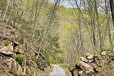
 Columbia Trail in High Bridge, New Jersey | |
| Length | 15.0 mi (24.1 km) |
| Location | Hunterdon County&Morris County |
| Trailheads | Main Street inHigh Bridge,Bartley Road inWashington Township |
| Use | Hiking,Cycling |
| Difficulty | Easy |
| Season | Year round |
| Surface | Stone dust |
| Right of way | Central Railroad of New Jersey |
TheColumbia Trailis arail trailin rural northwesternNew Jersey.It was created from portions of the formerCentral Railroad of New JerseyHigh Bridge Branchand stretches fromHigh Bridge,inHunterdon County,throughWashington Township,inMorris Countyfor a total of 15.1 miles (24.3 km). The trail surface is relatively flat and consists mostly of fine crushed stone.
History
editLewis H Taylor, a member of the trustees of the Central Jersey Railroad, brought the railroad to High Bridge in 1876. The branch line was originally built to transport coal andiron orefrom mines in Morris County for use in theTaylor Wharton Iron and Steel Company,the oldest foundry in United States History,[1]and otherfoundriesat High Bridge orWharton.TheHigh Bridge Branchwas also used for passenger traffic until 1935.
In 1976, the branch was deemed redundant by its new owner,Conrail,and the rails were dismantled in 1980. In the mid-1990s, theColumbia Gas Transmissioncompany bought the trail right-of-way and laid an undergroundgaspipeline under theright-of-wayalong the length of the trail. The trail and bridges were resurfaced in 2004. Since then, it has been a recreational trail serving the surrounding communities.
The Hunterdon County Division of Parks and Recreation[2]and Morris County Park Commission[3]now operate and maintain the trail under lease, although ownership of the right-of-way remains with the Columbia Gas Company.
A train wreck occurred on theKen Lockwood Gorge Bridgeon April 18, 1885. An iron ore train led by the coincidentally named Columbia Engine derailed on the trestle and crashed into the river below.[4]Iron Mine Railroads of Northern New Jersey,by Larry Lowenthal, indicates this was engine 112 and does not indicate it had a name. A contemporary account of the wreck in the Iron Era[5]newspaper[6]does not cite a name, only the engine number. If the locomotive had a name it's probable it would have been mentioned in those days. The trail is, instead, most likely named for the Columbia Gas Pipeline.[citation needed]Minutes of meetings in Hunterdon Parks indicate that Hunterdon suggested the name "Columbia Trail", much to the satisfaction of the gas company. Recent oppositions to gas utilities, and their relationship tohydraulic fracturing(aka "Fracking" ) have spurred public outcry to rename the route "High Bridge Branch Trail", a more historically accurate and less controversial tag. Furthermore, it may be considered a conflict of interest for a government agency to promote a private industry such as Columbia Gas in name and associated publications (tax payer funded maps, guides, interpretive signage, etc.).
Route
editThe Columbia Trail runs fromHigh BridgeinHunterdon Countynortheast toWashington TownshipinMorris County.The route is scenic, as the meanderingSouth Branch of the Raritan Riverparallels the trail along most of its route across two counties. The trail passes throughCalifonin Hunterdon County andLong Valleyin Morris County. Just north of Long Valley,Patriots' Pathprovides links east towardsCounty Route 513and west towards Schooley's Mountain Park. Also in Long Valley the trail runs adjacent to the New Jersey Department of Environmental Protection South Branch Wildlife Management Area which has some unmarked trails to the north.
Beyond the northeastern end of the trail on the border of Washington and Mt. Olive Townships, an active rail line is still in service and operated by theMorristown and Erie RailwaytoWharton.The trail connects to theNew Jersey TransitRaritan Valley Lineat High Bridge and connects to Patriots Path inLong Valley.
A notable portion of the Columbia Trail is theKen Lockwood Gorge,betweenCalifonandHigh Bridge(2+1⁄2miles north of High Bridge). TheSouth Branch of the Raritan Riverparallels the trail through the gorge, and is a scenic fast-flowing smallriverwith recreational activities, especiallyfly fishing.A 60-foot (18 m)trestlecarries the trail over the river in the gorge.
There are few remnants of the former rail line along the trail, except for the occasional rotting railroad cross ties along the trail. There is a small section of track preserved in Califon and a small and rarely open museum dedicated to the rail line history is located in the preserved train station in the town center.
Trail access
editThe southern trailhead is located inHigh Bridgeat 79 Main Street. The trail begins on the east side of Main Street across from the entrance to Commons Park, where parking is available.
The northern trailhead is located inWashington Twpat the border with Mt. Olive on Bartley Road (Morris Cty 625). There is a small public parking area across from the current end of the Morristown & Erie rail line. There is another public parking area inLong Valleyoff Schooley's Mountain Road between Fairview Avenue and Maple Lane, across from The Coffee Potter (the old Long Valley train station when theCentral Railroad of New Jerseytrain line passed through the area).
Gallery
edit-
 Trailside view of Lake Solitude and Waterfall in High Bridge
 -
 Passing through theKen Lockwood Gorge
 -
 Approaching theKen Lockwood Gorge Bridge


References
edit- ^Connecting trail
- ^"Official Web site - Hunterdon County".Archived fromthe originalon 2017-10-03.Retrieved2018-12-12.Archived2017-10-03 at theWayback Machine
- ^Official Web site - Morris County[dead link]Archived2014-05-14 at theWayback Machine
- ^County of Hunterdon - Department of Parks and Recreation."The Gorge Bridge Train Wreck. The High Bridge Branch of the Central Railroad of New Jersey".Historical Marker Database.
- ^"The 1880s - the Iron Era Newspaper Online: Rockaway Township Free Public Library - Rockaway, New Jersey, NJ".Archived fromthe originalon 2014-10-17.Retrieved2014-10-13.
- ^"Archived copy"(PDF).Archived fromthe original(PDF)on 2014-10-17.Retrieved2014-10-13.
{{cite web}}:CS1 maint: archived copy as title (link)
External links
edit Media related toColumbia Trailat Wikimedia Commons
- Columbia Trail mountain biking
- Rails to Trails Conservancy Trail Information Page
- "Columbia Trail".New York–New Jersey Trail Conference.21 October 2016.
- "Ken Lockwood Gorge and the Columbia Trail".NY–NJ Trail Conference. 21 October 2016.
- Photo Gallery