Kildwick,orKildwick-in-Craven,is a village andcivil parishof thedistrictofCraveninNorth Yorkshire,England. It is situated betweenSkiptonandKeighleyand had a population of 191 in 2001,[2]rising slightly to 194 at the 2011 census.[1]Kildwick is a landmark as where the major road from Keighley to Skipton crosses theRiver Aire.The village's amenities include a primary school, church and public house.
| Kildwick | |
|---|---|
 Kildwick Location withinNorth Yorkshire | |
| Population | 194 (2011 Census)[1] |
| OS grid reference | SE008461 |
| Civil parish |
|
| Unitary authority | |
| Ceremonial county | |
| Region | |
| Country | England |
| Sovereign state | United Kingdom |
| Post town | KEIGHLEY |
| Postcode district | BD20 |
| Dialling code | 01535 |
| Police | North Yorkshire |
| Fire | North Yorkshire |
| Ambulance | Yorkshire |
| UK Parliament | |
History
editEtymology
editThe first known documentation of Kildwick's name is asChildeuuicin theDomesday Book.InLatin,thedigraph chis pronounced/kʰ/not/tʃ/so its pronunciation was the same as it is now.
The meaning of its name depends on whether it was named by the conqueringVikingsor earlier inOld English.However, no evidence of the latter is known, and other place names nearby are predominantlyOld Norse.

- Kild. In Old Danishkildemeans either a spring[3]like inKeld43 miles (69 km) to the north, or a large smooth body of water.Keldahas its roots inketil,cauldron, from theProto-Germanic languagekiltham,a vessel for nourishment. It is often proposed that Kild mean child since it comes from that same root.kilþeimeans womb inGothicand thence Old Englishcild,child or kin, but the town name is not Old English but Norse and so Kild describes the floodplain of theRiver Airewhen flooded.
- Wick means a community settlement[4]from the etymological root ofProto-Indo-Europeanweikmeaning clan, c.f.Sanskritvitsettlement;Old Iranianvisclan, house, village.[5]InProto-Germanicetymology,wīcorvikdeveloped several meanings: Kildwick could mean ariver portlikeGreenwichor atrading placelikeNorwich,[6]butdairy farmdoes not apply for that meaning was used only in thesouth of England.[7]Hence in Kildwick's case its name means river port.
Property
editTheDomesday Bookof 1086 has the first record of Kildwick in writing. It lists the Lord of the Childeuuic manor as Arnkeld with about 240 acres (100 hectares) of ploughland and anAnglo Saxonchurch.
However,William the Conquerorshortly deposed all theAngle-Danelords and rewarded his greatNormanwarriors. Ruling over-all inCravenwasRobert de Romille.In 1120 Robert's heir Cecilia de Romille, Lady of Skipton, founded an Augustine priory at Embsay near Skipton and endowed it with themanor/estateof Kildwick.[8]In 1153 the proprietors of Kildwick moved their priory toBolton Abbey.
From 1305 to 1313, Bolton Priory paid for the bridge over the River Aire to be built in stone. They also built Kildwick Grange as a local residence.[8]
In 1539, Henry VIII dissolved the monastery atBoltonand granted Kildwick manor to Robert Wilkinson and Thomas Drake of Halifax but granted the church toChrist Church, Oxford.
In 1549, Thomas Drakealienatedthe Manor to John Garforth of Farnhill. In 1558, the Garforths sold it all to the Currer family with whoselinealdescendants it remains.[9]
Population
edit- 1379Poll Taxrecorded Kildwicktownshipas having only 10 households, all paying the minimum tax.[10]: 44
- 1672Hearth Taxcounted 25 households in the township with mostly but one fireplace, but also the 14-hearthedmanor house.
- 1821 parish registered 8,605 inhabitants.
- 1831 parish was 9,926 however township only 190.[11]
- 1881 the parish had been divided so district down to 8,923.
- 1891 district up to 9,859 but township down to 145.[10]: 20–21
St Andrew's Church
edit
St Andrew's is a historically significant church. Fragments of 10th-century crosses have been excavated from its walls, evidence of theAnglo Saxonchurch built here before theNorman conquest.It was replaced by one of stone in the 12th century. Cecilia de Romille gave the church toBolton PrioryinWharfedale,the Manor of Kildwick coming under the jurisdiction of the Priors of Bolton.
After the Battle of Bannockburn in 1314 Scots raiders sacked Bingley and Bradford Churches, but spared Keighley and Kildwick Churches because they were dedicated to St. Andrew, patron saint of Scotland.[12]However, in 1318 the church building was badly damaged by Scottish raiders.[13]
In 1539 Henry VIII dissolved the monastery and granted the church to Christ Church, Oxford. In the reign of Henry VIII under the patronage of Christ Church the church was almost entirely rebuilt.[9]During the 15th and 16th centuries the church was lengthened, with further extensions eastwards so that it is now one of the longest in Yorkshire hence known locally as 'The Lang Kirk of Craven'.
The church wasrestoredin 1873 by theLancasterpartnership ofPaley and Austin.[14]Changes have taken place since then, including extension of thechanceland a further restoration of thenavein 1901–03 by the successors in the Lancaster practice,Austin and Paley.[15]
Charlotte Brontëand other members of theBrontë familywere acquainted with the church.
Kildwick Parish
editAncient Kildwick Parish was unusually large for it included the townships of Kildwick,Bradley Both,Cononley,Cowling,Holden,Eastburn,Farnhill,Glusburn,Ikornshaw,Silsden,Steeton,Sutton[16][17]andStirton and Thorlby.[9]
| Location | curactes (120 acres/50ha) | other property | Taxpayer |
|---|---|---|---|
| Kildwick | 2 | 1 church | Archil |
| Eastburn | 3 | 2 oxgangs | Gamalbern |
| Cononley | 2 | Torchil | |
| Bradley | 7 | Archil, Torchil, Gamel | |
| Farnhill | 2 | Gamel | |
| Sutton | 2 | Ravenchil | |
| Steeton | 3 | was Gamalbern now Gilbert Tison | |
| Glusburn | 3 | was Gamalbern now Gilbert Tison | |
| Glusburn | 3 | was Gamalbern now William de Percy | |
| Silsden | 8 | five Thanes of Osbern de Arches |
In the mid 19th century the advent of textile factories caused rapid growth of some of the townships. It became anomalous for residents of those expanding towns to have to travel to a tiny village to be baptised, married and buried. In consequence the parish was divided, for example the other side of the River AireSutton-in-Cravenwas constituted as a separate ecclesiastical district in 1869 and built its own parish church. However adjacentCross Hillsis still in the parish of Kildwick.
Education
editEducation in Kildwick has a substantial history. In 1563 and 1564 theArchbishop of York’sVisitation Actbooks records a schoolmaster at Kildwick.[18][19]And the nationalHearth taxof 1672 records “George Ellmott for the Freeschoole, 2 hearths” untaxed in Kildwick.[20][21]In 2012 the School is adjacent to the parish church on Priest Bank Road and is known asKildwickChurch of EnglandVoluntary ControlledPrimary School.It caters for girls and boys age range 4 to 11; maximum number of pupils per grade 17.[22]
Transport
editRoad
editKildwick is a landmark in Craven being the point at which the main road from Keighley to Skipton crosses the River Aire. Kildwick is made a natural crossing place by the spur of land from Crosshills that dramatically narrows a wide valley prone to flooding. This spur is a first river terrace deposit of silt and sand with gravel lenses. It has been enlarged downstream by about 60 acres (25ha) of made ground.[23]
-
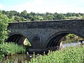 Kildwick Bridge west side built 1305–13 with ribbed vaulting
 -
 Kildwick Bridge east side built 1780
 -
 Below the bridge after days of heavy rain
 -
 The River Aire flooding above the bridge


From 1305 to 1313Bolton Abbeypaid for "Aire-brigg"to be built in stone[24]however wooden bridges had existed there many centuries before that.[25]The bridge at Kildwick is the first stone bridge recorded inCravenand the oldest bridge inAiredaleand has been designated aGrade Ibuilding.[26]
TheKeighley and Kendal TurnpikeTrust operated from 1752 to 1878. It was promoted mostly by textile manufacturers ofSettle[27]on the grounds that transportation costs to be greatly reduced since waggons on good roads need half the number of horses required for carrying packs. It was built to a standard width of 7 yards of which 5 were metaled.
In 1780 the bridge was widened for the Turnpike and isstructurallytwo bridges standing side‐by‐side. The upstream side with ribbedvaultingand two pointed arches is the 14th-century original. The downstream side has only plain round arches.

In 1823 theBlackburnAddinghamroad opened. Sixstagecoachesa day passed through the area. However the Keighley Kendal Road proved a commercial failure and ceased in debt in 1878. The roads passed into the care of the County Council.
By 1968 the road traffic volume found such a bottleneck at the bridge and village it necessitated the building of theA629and bridge tobypassit; completed in 1988.[28]
Canal
editKildwick village is so close to the canal that they touch. In 1773 theBingleytoSkiptonsection was the first section of theLeeds and Liverpool Canalto be completed. By 1781 the canal joinedLeedstoGargrave,and in 1816 completed the link toLiverpool.It was of benefit for transport of supplies and goods from the textile mills that stood on the other side of the river.
-
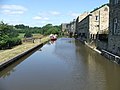 The Leeds and Liverpool Canal at Kildwick
 -
 Houses by the canal
 -
 Road going beneath the canal
 -
 Canal footbridge to Farnhill


Rail
editIn 1847 theLeeds and Bradford Extension Railwayopened itsShipleytoSkiptonsection throughKildwick and Crosshills railway station.Kildwick was thus served by rail until the station was closed in 1965.Steetonis the nearest railway station.
Main sights
edit-
 The war memorial and the White Lion pub
 -
 Kildwick Hall
 -
 The start of the Kildwick Moor footpaths


Notable people
edit- Stephen Barrett(1718–1801), teacher of classics, was born at Bent, in the parish of Kildwick.
- Katie Griffiths(born 1989), actress, grew up in Kildwick.
- Henry Mosley(1852–1933), first-class cricketer, was born in Kildwick.
- Clare Teal(1973–), English jazz singer, was born in Kildwick.
- John Webster (alias Johannes Hyphastes)(1610–82), clergyman and physician, became curate at Kildwick in 1634.
References
edit- ^abUK Census(2011)."Local Area Report – Kildwick Parish (1170216764)".Nomis.Office for National Statistics.Retrieved9 April2018.
- ^"Kildwick CP (Parish)".Neighbourhood Statistics.Office for National Statistics.Retrieved25 April2008.
- ^Harrison, Henry (1996).Surnames of the United Kingdom: A Concise Etymological Dictionary.
- ^Lambert, Tim."The origins of some English place names".Localhistories.org.Retrieved15 August2010.
- ^"Villa".Online Etymology Dictionary.Retrieved15 March2012.
- ^Ekwall, Eilert(1960).The concise Oxford dictionary of English place-names(4 ed.). Oxford: Oxford University Press. pp. 275, 345, 516.ISBN0-19-869103-3.
- ^The Century dictionary and cyclopedia. Vol 10,William Dwight Whitney,Benjamin Eli Smith. Century Co. 1909.
- ^abJohn Murray (1904) Handbook for YorkshireRetrieved 10 January 2012
- ^abcGenuki, The Ancient Parish of KildwickRetrieved 10 January 2012
- ^abHarry Speight (892)The Craven and North-west Yorkshire highlandsRetrieved 10 January 2012
- ^Pigot's Directory 1834Retrieved 15 January 2012
- ^Keighley Shared Church HistoryRetrieved 10 March 2016
- ^Overend, Harry (2003)."Kildwick Parish Church".Archived fromthe originalon 24 November 2011.Retrieved10 January2012.
- ^Price, James (1998).Sharpe, Paley and Austin: A Lancaster Architectural Practice 1836–1942.Lancaster: Centre for North-West Regional Studies. p. 83.ISBN1-86220-054-8.
- ^Brandwood, Geoff; Austin, Tim; Hughes, John; Price, James (2012).The Architecture of Sharpe, Paley and Austin.Swindon:English Heritage.p. 244.ISBN978-1-84802-049-8.
- ^Whitaker, Thomas Dunham. "The Parish of Kildwick".The History and Antiquities of the Deanery of Craven(PDF).Skipton Castle. pp. 207–221.Retrieved19 June2012.
- ^Whitaker, Thomas Dunham (1812).The History and Antiquities of the Deanery of Craven in the County of York.Historical Print Editions. British Library.ISBN1241342695.
- ^Lawson, John (1959).Primary Education in East Yorkshire 1560–1902.Yorkshire: East Yorkshire Local History society.
- ^Lawson, J. (1959)."Primary Education in East Yorkshire 1560–1902"(PDF).Archived fromthe original(PDF)on 20 May 2015.Retrieved1 July2012.
- ^"Hearth Tax of Charles II".National Archive UK.Retrieved1 July2012.
- ^"West Riding".Hearth Tax Online.London: Roehampton University. Archived fromthe originalon 19 September 2012.Retrieved1 July2012.
- ^Kildwick Church of England VC Primary SchoolRetrieved 1 July 2012
- ^British Geological Survey, England and Wales Sheet 69: Bradford, solid and drift edition 1:50000 series, published 2000
- ^Roy Mason (15 March 1980). "Bridge that was built to last".Bradford Telegraph and Argus.
- ^Rev Brereton (1909)."The History of Kildwick Church".Archived fromthe originalon 19 July 2011.Retrieved7 November2010.
The original book scanned and put online by St Andrew's Church
- ^Historic England."KILDWICK BRIDGE (1167718)".National Heritage List for England.Retrieved17 June2015.
- ^Brigg, John J. (1927).The King's Highway in Craven, with sketch maps.
- ^Taylor, Graham."From Keighley to Skipton – a journey of 1900 years"(PDF).Archived fromthe original(PDF)on 21 August 2017.Retrieved5 December2017.