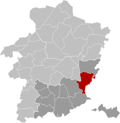
Lanaken(Dutch pronunciation:[ˌlɑˈnaːkə(n)];Limburgish:Laoneke) is amunicipalitylocated in theBelgianprovince ofLimburg.On January 1, 2007, the municipality of Lanaken had a total population of 24,724. Its area is 59.00 km2which gives apopulation densityof 415 inhabitants per km2.
Lanaken | |
|---|---|
 Zuid-Willemsvaartat Smeermaas | |
| Coordinates:50°53′N05°39′E/ 50.883°N 5.650°E | |
| Country | |
| Community | Flemish Community |
| Region | Flemish Region |
| Province | Limburg |
| Arrondissement | Tongeren |
| Government | |
| • Mayor | Marino Keulen (Open Vld) |
| • Governing party/ies | Open Vld,Vooruit-Groen |
| Area | |
| • Total | 58.95 km2(22.76 sq mi) |
| Population (2018-01-01)[1] | |
| • Total | 25,818 |
| • Density | 440/km2(1,100/sq mi) |
| Postal codes | 3620-3621 |
| NIS code | 73042 |
| Area codes | 089 |
| Website | www.lanaken.be |
Lanaken is located on theBelgian-Dutchborder, borderingMaastrichtdirectly. In the 2006 census, some 20 percent of the inhabitants turned out to have the Dutch nationality. A number of neighbourhoods in Lanaken is characterized by these immigrants' numerous villas and exclusive landhouses.
Lanaken consists of the following villages: Lanaken proper,Rekem,Neerharen,Gellik,Veldwezelt,SmeermaasandKesselt.Also located in Lanaken are the hamletsBriegdenandHerbrichtand the old village centreOud-Rekem.
TheVeldwezelt-HezerwaterPalaeolithicarchaeological siteis located in the municipality.
History
editArchaeological finds on the territory of Lanaken are known from theNeolithic,RomanandMerovingianperiods. There were severalGallo-Romancemeteries and in Smeermaas was the Gallo-Roman villa of Smeermaas was located.
In theMiddle Ages,the domain of Lanaken probably belonged to the emperor of theHoly Roman Empire.From the 12th century Lanaken was part of theseignioryof Pietersheim of Loon, whose lords founded the Abbey of Hocht around 1186. In 1106 the patronage right of the parish church was given to the Maastricht chapter of St. Servaas.
In 1808 the present borough was formed, merging Lanaken with Smeermaas, Hocht, Pietersem, Ca(u)berg, Bessemer and Briegden. In 1839, as a result of theBelgian revolutionand subsequentTreaty of London,the municipality was split into a Belgian and a Dutch part (Caberg). Caberg then became an independent parish. Smeermaas received its own church in 1870. The borough of Bessemer was later incorporated into the municipality ofZutendaal.
From 1824-1829 theSouth Willemsvaartwas built, and from 1930-1934 the Briegden-Neerharen canal. These canals cut through the territory of Lanaken. In 1856 followed the Hasselt-Maastricht railroad line, which was closed to passenger traffic in 1954.
On October 4, 1914, duringWorld War I,the center of Lanaken was set on fire by the Germans, partly in retaliation for the resistance of a Belgian volunteer group led by Mayor Edgard de Caritat de Peruzzis. The castles of de Caritat de Peruzzis and Alicebourg were then blown up.[2]
On May 10, 1940, duringWorld War II,German planes bombed the barracks of de Caritat de Peruzzis killing Captain-Commander Henri Giddelo and five other soldiers.
In 1957, the Saint Barbara Hospital in Lanaken was established by the Limburg mines to enable research and combat occupational diseases, especially dust lung, which mostly affected the miners of the Kempen coal basin.
On January 1, 1977, Lanaken merged with the surrounding municipalities of Gellik, Neerharen, Rekem and Veldwezelt to form the present municipality of Lanaken.
Etymology
editLanaken was mentioned in 810 asLudinacaand in 1106 asLodenaken.This contains the personal nameHlodoorLudofollowed by the wordhaka,meaning sand plate.[3]
Nature and landscape
editLanaken is characterized by being located on the southern edge of theKempen Plateau,separated from the more southern region ofHaspengouwby theAlbert Canal.To the southeast, Lanaken is cut off from Smeermaas and the Maas basin by theBriegden-Neerharen Canal.Lanaken itself lies at an altitude of about 60 meters, to the northwest one finds steep edges to the plateau, which reaches heights of up to 100 meters, and the deeply cut valleys of the brooks Asbeek and Ziepbeek. This part, which is part of theHoge Kempen National Park,has marshy lowlands, heaths, and forests, consisting of coniferous forest, once planted for the production of mining wood, and mixed forest. The most famous areas are Pietersembos and Asbroek.
Marked walks through this area start both at Pietersheim Castle and at the parking lot near the Saint-Barbara Hospital.
Economy
editLanaken grew as a result of the presence of railroad and canals, there was commuter traffic to Maastricht, and jobs were created at the Eisden coal mine. Also established were a paper factory (today:Sappi), a rubber factory (today: Hercorub) and a factory for synthetic fibers (Celanese), among others.
In 2006, four 100 meter high wind turbines were built to provide electricity to the Celanese factory. Later on 8 more have been built.
TheSouth Africanpulp and paper company Sappi operates a large mill on the outskirts of the town and is an important source of employment for the town's residents. In October 2023, Sappi announced the closure of their facility in Lanaken.[4]
Lanaken is part of theAlbert Canal Economic Networktogether with 24 other municipalities through which the canal runs.[5]
Transportation
editThe reactivation of the former railwayMaastricht-Lanaken-Hasseltas alight railknown as theHasselt – Maastricht tramwayas part of the Belgian Spartacus plan was scheduled for 2014. It was later postponed to 2025, to be later canceled in June 2022 and in favour of an electric "trambus" which will start operations in 2024.[6]
Born in Lanaken
edit- Eric Gerets(1954) Former professional football (soccer) player for Belgium, born in Rekem
- Edgar Willems(1890–1978), artist, musician, and music educator
- Jeroen Kusters(1980) renowned supply chain planning expert, operations management leader and technologist
Gallery
editReferences
edit- ^"Wettelijke Bevolking per gemeente op 1 januari 2018".Statbel.Retrieved9 March2019.
- ^"Lanaken had een Engelse tuin tot de Duitsers in 1914 langskwamen".www.hbvl.be(in Flemish). 2022-01-23.Retrieved2023-10-17.
- ^"Lanaken".inventaris.onroerenderfgoed.be(in Dutch). 1996.Retrieved2023-10-17.
- ^"Papierfabriek Sappi in Lanaken sluit, 550 jobs op de tocht".De Morgen.2023-10-10.Retrieved2023-10-28.
- ^"Economisch Netwerk Albertkanaal (ENA)".
- ^"Het is zover: elektrische trambussen rijden vanaf 2024 in Limburg maar je zal er ook nu al veel van merken".www.hbvl.be(in Flemish). 2023-06-17.Retrieved2023-10-17.
External links
edit- Media related toLanakenat Wikimedia Commons
- Official website- Available only inDutch


