This articleneeds additional citations forverification.(January 2014) |
Mühlhausen(German:[ˈmyːlhaʊzn̩]) is a town in the north-west ofThuringia,Germany, 5 km (3 miles) north ofNiederdorla,the country'sgeographical centre,50 km (31 miles) north-west ofErfurt,65 km (40 miles) east ofKasseland 50 km (31 miles) south-east ofGöttingen.
Mühlhausen | |
|---|---|
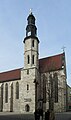
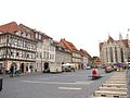
 Divi-Blasii Church seen from Kornmarkt | |
 Coat of arms | |
Location of Mühlhausen within Unstrut-Hainich-Kreis district  | |
 Mühlhausen  Mühlhausen | |
| Coordinates:51°13′N10°27′E/ 51.217°N 10.450°E | |
| Country | Germany |
| State | Thuringia |
| District | Unstrut-Hainich-Kreis |
| Government | |
| •Lord mayor(2024–30) | Dr. Johannes Bruns[1](SPD) |
| Area | |
| • Total | 150.53 km2(58.12 sq mi) |
| Elevation | 216 m (709 ft) |
| Population (2022-12-31)[2] | |
| • Total | 37,048 |
| • Density | 250/km2(640/sq mi) |
| Time zone | UTC+01:00(CET) |
| • Summer (DST) | UTC+02:00(CEST) |
| Postal codes | 99974 |
| Dialling codes | 03601 |
| Vehicle registration | UH, LSZ, MHL |
| Website | www.muehlhausen.de |
Mühlhausen was first mentioned in 967 and became one of the most important cities in central Germany in the late Middle Ages. In the mid-13th century, it became aFreie Reichsstadt,an independent and republican self-ruled member of theHoly Roman Empire,controlling an area of approximately 220 square kilometres (85 sq mi) and 19 regional villages. Due to its long-distance trade, Mühlhausen was prosperous and influential with a population of 10,000 around 1500. Because it was spared from later destruction, Mühlhausen today has a great variety of historical buildings with one of the largest medieval city centres remaining in Germany, covering a surface of more than 50 hectares within the inner city wall and approximately 200 hectares overall. There are eleven Gothic churches, several patricians’ houses and a nearly completely preservedfortification.
Johann Sebastian Bachworked as the city's organist in 1707–08. The theologianThomas Müntzer,a leading person in theGerman Peasants' War,gave sermons here and was executed outside the city walls.John A. Roebling,the constructor of theBrooklyn Bridge,andFriedrich August Stüler,an influential architect in mid-19th-centuryPrussia,were born in Mühlhausen.
Mühlhausen is within theThuringian Basin,a flat and fertile area, on theUnstrutriver on the eastern edge of theHainichhills.
History
editMiddle Ages
editAccording to legend, in the 5th centuryAttilastayed at "Burg Mulhus" as a guest of hisThuringiiallies before moving on to theBattle of the Catalaunian Plains.[3]: 43 Within the north-eastern parts of the city centre around St. George's Church, sizeable archaeological finds have been made, relating to a large settlement of the Thuringii/Franciaperiod (from the 6th to the early 10th century), which can be seen as the origin of the later city. Mühlhausen itself was first mentioned in 967 was part of a territory given byOtto IIto his wifeTheophanu.[3]: 43 It belonged to theReichsgutab initio,i.e. there was no territorial lord other than the German emperor and the area was not the emperor's own property, so that it did not go to his son after his death but reverted to his successor as emperor, even if he was from another family. The emperors had aKaiserpfalzin Mühlhausen, which they often visited fromOtto IIItoHenry IIIduring the 10th and 11th centuries.[3]: 43 The election ofPhilip of Swabiain 1198 ended with a homage in Mühlhausen, attended byWalther von der Vogelweide.
In 1135, Mühlhausen was first referred to as avillawhich can be seen as the beginning of the evolution from a settlement to a city.[4]: 200 During the early 12th century, the "old town" was set up around theUntermarktalong theHessenweg,an important trade route between theKasseland theErfurtregions. The fortifications were erected after 1170, eventually including 52 towers.[3]: 43 [4]: 200 In the early 13th century, the "new town" north of Schwemmnotte river followed with a regular grid around St. Mary's Church andObermarktwithSteinwegas main streets. TheTeutonic Knightsreceived St. Blaise's Church (Divi-Blasii) in 1227 and St. Mary's Church in 1243 from the emperor, which ensured them influence in the city and high revenues. The largest monastery of Mühlhausen was the 1227-foundedBrückenklosteratMagdalenenweg,a Magdalenians monastery. It held large estates in the region and its buildings were demolished in 1884. TheFranciscanscame to the city in 1225 and built their monastery around today's Corn Market Church and theDominicansestablished a monastery in 1289 nearSteinweg;their church was demolished after a fire in 1689, only some walls remained. Jews have lived in Mühlhausen at least since the late 13th century; theJüdenstraßeruns parallel toSteinwegin the new town. During theBlack Death Jewish persecutionsin 1349, many Mühlhausen Jews were killed.

In the mid-13th century, the citizens emancipated more and more from the emperor's rule. For example,Conrad IVhad to concede the established wall between the city and theKaiserpfalz(emperor's court) and later in the 13th century, the citizens destroyed the court. From 1251, Mühlhausen was referred to as aFreie Reichsstadtand became the second most powerful city in Thuringia afterErfurt.[3]: 43 The "Mühlhausen Law Book" (1224) is the oldest book of law in the German language and regulated the law of the city. In 1308/09, Mühlhausen allied with Erfurt andNordhausenagainst theWettins,who tried to get these three major Thuringian cities under their rule. The alliance lasted nearly 200 years and was successful. After 1348, Mühlhausen did not have to pay any more taxes to the emperor, so that its independence was complete. The three cities pursued their own territorial policy (e.g. by buying castles) to protect their trade routes against robbery, which brought them constantly into conflict with local nobles. Another aspect of the territorial policy was buying land and villages around the city, making use of any opportunity that presented itself, for example if local rulers (counts, monasteries etc.) needed money. Mühlhausen bought 19 still existing and 43 later abandoned villages and an area of 220 km2(85 sq mi) in this way, covering the north-western part of today's districtUnstrut-Hainich-Kreis.The villages had to pay taxes to Mühlhausen and were secured by the MühlhausenLandwehr,a moat of 24 km (15 mi) length with several towers (Warte) to observe the region.
The economic heyday between the mid-13th and the early 16th century was a result of long-distance trade with textiles,woadand other goods. In 1286, Mühlhausen had joined theHanseatic League.By the mid-15th century it was one of the largest cities in Germany.[4]: 200
Early modern period
edit
TheReformationbrought disturbances to Mühlhausen. The monk and peasant leaderHeinrich PfeifferfromReifenstein Abbeypreached at St. Mary's in February 1523 for the first time, followed byThomas Müntzerin August 1524. Both had not only religious demands (they were members of theAnabaptistmovement) but also political ones, aimed against the privileges of the magistracies and their oligarchic rule over the city. The city council was deposed and replaced by an "Eternal Council" (Ewiger Rat).[4]: 201 During theGerman Peasants' War1524/25, the city's monasteries were looted and theBildersturmdevastated the churches. After the emperor's army defeated the uprising, Müntzer, Pfeiffer and other leaders were executed. Müntzer's execution on 27 May 1525 took place right outside the city.[3]: 46 Furthermore, the city had to pay a fine of 40,000 guilders to the empire and partially lost its independence, because theHessiansand both lines of theWettins(Ernestines and Albertines) were appointed to control the city government. By contrast to these three rulers, Mühlhausen remained Catholic and became a secret member of theNuremberg League,an alliance of catholic territories in the empire, founded in 1538. After the three rulers realized that in 1542, the Reformation was introduced by force in Mühlhausen byJustus Menius.TheSchmalkaldic Warresulted in the defeat of the Hessians and the Ernestines by the emperor in 1547 and partially returned the city's independence. In foreign policy it had to coordinate with the Albertines and it had to pay taxes to the empire. After 1710,Hanoverwas Mühlhausen's protecting power.
Johann Sebastian Bachwas organist of the churchDivi Blasiifrom 1707 until 1708.[4]: 202 Among the works Bach composed while living in the town was an elaborate, festive cantata,Gott ist mein König,BWV 71,for the inauguration of the new council in 1708.
Internal dissensions and destruction caused during theThirty Years' War(1618–1648) and theSeven Years' War(1756–1763) helped in bringing about Mühlhausen's decline. In addition,Leipzig's rise as a trade fair town and new long-distance trading routes likeVia Regiaalso contributed by decreasing the city's trade and damaging the finances of the city.[3]: 43–44 TheGerman mediatizationled to the formal loss (that had de facto already occurred) of Mühlhausen's independence in 1803, as the city became part ofPrussia.During theNapoleonic Warsit was part of theKingdom of Westphaliafrom 1807 until 1815, when it became part of Prussia again according to the decisions of theCongress of Vienna.
Since 1815
editAfter 1815, Mühlhausen was part of the newly created PrussianProvince of Saxony,where the Mühlhausen district was established. In 1831, the Mühlhausen-born civil engineerJohn A. Roebling,later constructor of theBrooklyn Bridge,emigrated to the United States. The era of industrialisation and urbanisation reached Mühlhausen relatively late, around 1870, when the city was connected to the railway by a line fromGothatoLeinefelde.In 1892, Mühlhausen became an independent city district. In 1898, the municipal power station was founded and the tramway network started its operation in Mühlhausen. Major industries were textiles and engineering.

Between 1910 and 1917, the provincial hospital of Pfafferode was built on the western edge of the city, one of the largest hospitals in the Prussian Province of Saxony. TheGreat Depressionafter 1929 hit Mühlhausen very hard and led to massive unemployment. In 1935, the Nazi armament campaign resulted in the building of a large military complex with several barracks with the deliberate side effect of boosting the city's weak economy. The synagogue was damaged during theKristallnachtin November 1938, but as one of only a few in Germany, it was not completely destroyed and still stands today. At the Pfafferode hospital, nearly 2,000 patients were killed or died during the Nazi period (Action T4), most of them were mentally or physically disabled. From 1944 to March 1945, a women's forced labour camp was located directly outside Mühlhausen (a branch of theBuchenwaldcamp), producing arms. The women were deported in April 1945 toBergen-Belsen concentration camp.TheUS Armyarrived in Mühlhausen on 4 April 1945 and the city was handed over without a fight. On 5 July 1945, theSoviet Armytook over the city, which became part of theGDRin 1949.
In 1975, the 450th obit ofThomas Müntzer,the city was officially renamedThomas-Müntzer-Stadt Mühlhausen.Müntzer and the German Peasants' War received a lot of attention from the GDR government and East-German historians; they referred to it asFrühbürgerliche Revolution(early bourgeois revolution) and included it in theirMarxistconception of history. Many exhibitions were set up (including some of the museums in Mühlhausen and theBauernkriegspanoramanearBad Frankenhausen) and events celebrating the historical connection took place. AfterGerman reunification,the focus on Müntzer and the Peasants' War ended. The city name was changed back to plain "Mühlhausen" in 1991.
After reunification, many factories in Mühlhausen were closed, leading to another deep economic crisis with high unemployment rates during the 1990s and early 2000s. On the other hand, the city's architectural heritage was rediscovered and the restoration of the historic city centre began.
Geography and demographics
edit
Topography
editMühlhausen is situated in the flat landscape of theThuringian Basin,a very fertile area covering the northern centre of Thuringia at an elevation of approximately 215 metres above sea level. To the north and west, the terrain gets hilly, whereas to the south and east lie wide agricultural areas, much like most of the municipal territory itself. Furthermore, there are two forests within the territory: theStadtwald(as part of theHainich) in the west and theMühlhäuser Hardtbetween the Windeberg district andMenteroda.Both are broadleaf forests withbeechesprevalent. The Hainich hills south-west of Mühlhausen became Thuringia's onlyNational Parkin 1997 because of their old near-natural beech forests. The highest hills within the Mühlhausen terrain reach approximately 400 metres of elevation. The main river crossing the city in northwest–southeast direction is theUnstrut.Furthermore, there are many small tributaries running from the western hills through Mühlhausen to the Unstrut like the Schwemmnotte, which is dividing the inner city.
Germany's accurate geographical centre is located only 5 km (3 mi) south of the city in the neighbouring municipality ofNiederdorla,where a monument can be found at this spot.
Climate
editThe average annual temperature in Mühlhausen is 8.7 °C (47.7 °F).[5]
With an annual precipitation of only 565 millimeters (22.2 in), the climate in Mühlhausen is relatively dry, compared to other regions in Germany.
Administrative division
editMühlhausen abuts the following municipalities (all of them are part of theUnstrut-Hainich-Kreis):Anrode,UnstruttalandMenterodain the north,ObermehlerandKörnerin the east,Vogteiin the south andRodebergin the west. In the direction of Ammern (part of Unstruttal) there is no interruption in the build-up area, theRuhrstraßeforms an urban municipal border here.
The city itself (in addition to the core town) includes the following villages (population as of March 2021[6]):
| village | population | incorporated in |
|---|---|---|
| Bollstedt | 1,001 | 2019 |
| Eigenrieden | ca. 500 | 2024 |
| Felchta | 626 | 1994 |
| Görmar | 943 | 1994 |
| Grabe | 645 | 2019 |
| Hollenbach | 310 | 2023 |
| Höngeda | 723 | 2019 |
| Saalfeld | 162 | 1994 |
| Seebach | 655 | 2019 |
| Windeberg | 237 | 1992 |
The former municipalityWeinbergenwhich consisted of the villages Bollstedt, Grabe, Höngeda, and Seebach was merged into Mühlhausen in January 2019.[7]In January 2023 Mühlhausen absorbed the village Hollenbach from the former municipalityAnrode.[8]In January 2024 it absorbed the village Eigenrieden from the former municipalityRodeberg.[9]
Demographics
editMühlhausen had approximately 10,000 inhabitants during the late Middle Ages around 1500, which made it the second-largest number within today's Thuringia, afterErfurt,the current capital. Theearly modern periodbrought stagnation to the city, so that the population was still 10,000 around 1800. Mühlhausen fell back behind the new ducal residence cities likeWeimar,GothaorAltenburgin this period and lost its former importance. Furthermore, the traffic routes changed during the 19th century and Mühlhausen lost its good connections. Industrialization started later than in other German cities. Nevertheless, the population grew to 14,000 in 1850, 23,000 in 1880 and 35,000 in 1910, which was a significantly lower rate of growth than in other cities of comparable size during that period of rapid urbanisation in Germany. By 1940, the population had increased to 42,000 and with German refugees from eastern Europe, the peak was reached around 1950 with a population of 52,000. Since that time, the population has decreased to 43,000 in 1988, 39,000 in 2000 and 33,000 in 2012 (the statistical adjustment during the 2011 Census led to a loss of 3,000 persons).
The average decline in population between 2009 and 2012 was approximately 0.38% p.a, whereas the population in bordering rural regions has been shrinking with accelerating tendency. Suburbanization played only a small role in Mühlhausen. It occurred after the reunification for a short time in the 1990s, but most of the suburban areas were situated within the administrative city borders, others wereUnstruttalandWeinbergen.
The birth deficit was 203 in 2012, this is −6.1 per 1,000 inhabitants (Thuringian average: -4.5; national average: -2.4). The net migration rate was +1.2 per 1,000 inhabitants in 2012 (Thuringian average: -0.8; national average: +4.6).[10]The most important regions of origin of Mühlhausen migrants are rural areas of Thuringia as well as foreign countries like Poland, Russia, Ukraine, Hungary, Serbia, Romania and Bulgaria.
Like other eastern German cities, foreigners account for only a small share of Mühlhausen's population: circa 1.6% are non-Germans by citizenship and 4.2% overall are classified as migrants (according to the2011 EU census). Differing from the national average, the largest groups of migrants in Mühlhausen areRussiansandUkrainians.
Due to the official atheism of the formerGDR,most of the population is non-religious. 19.8% are members of theEvangelical Church in Central Germanyand 10.3% are Catholics (according to the 2011 EU census).
Culture, sights and cityscape
editMuseums
edit
There are several museums in Mühlhausen:
- TheMüntzergedenkstätteinside St. Mary's Church was opened in 1975 and shows an exhibition aboutThomas Müntzerand various other items of cultural history.[4]: 204
- TheBauernkriegsmuseuminside the Corn Market Church shows an exhibition about theBauernkrieg(German Peasants' War) and its importance for German history.[4]: 203
- TheMuseumsgalerieinside the All Saints Church hosts some art exhibitions: a permanent one with Thuringian art of different epoques and temporary ones of modern art.
- TheMuseum am Lindenbühlexhibits the municipal history of Mühlhausen and the regional history of north-western Thuringia including natural history and archaeology.[4]: 202
- TheWehrgangis part of the medieval city wall, accessible next to the Frauentor gate. It gives access to a large stretch of the city walls and the towers.[4]: 204
Cityscape
edit
The historic city centre of Mühlhausen consists of three parts. Within the inner city wall are theold town(south of Schwemmnotte river around Untermarkt and St. Blaise's Church) and thenew town(north of Schwemmnotte river around Obermarkt and St. Mary's Church). The former suburbiums of Mühlhausen are situated between the inner and the outer city walls. Like the inner city, they are of medieval origin, but in contrast from the core, this area was overbuilt often during the city's later history and today shows a mixture of old and new buildings. Within the inner city walls, most buildings date back to the Middle Ages. In the late 19th and the 20th century, the city grew into all directions and a relatively low density of buildings is typical for Mühlhausen, so that the built-up area is very large in relation to the number of inhabitants.
Characteristic for Mühlhausen's buildings is the predominant use of one kind of material –Travertine.It was found near the city in large quantities and is both light and solid, so that the Gothic churches with their filigree masonries and other important buildings could be built relatively cheaply. Nevertheless, many older citizens' houses were half-timbered constructions, with only the ground-floors made of stone.
Sights and architectural heritage
editChurches and synagogue
editMühlhausen is primarily known for its large number of intactGothicchurches:
Inside the inner city walls
edit- St. Blaise's Churchis the main church of the medieval Old Town at Untermarkt. It was built during the 13th century in early-Gothic style and is one of the most important 13th-century church buildings in Germany. It was first mentioned in 1227.[4]: 202 TheTeutonic Knights,owners of the church, had it expanded after 1270 using architects/builders fromMaulbronnandWalkenried.Johann Sebastian Bachworked here in 1707–1708 as organist. Today, it is the mainLutheranparish churchof Mühlhausen.[4]: 202
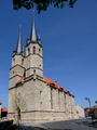
- St. Mary's Churchis the main church of the medieval New Town at Obermarkt. It was built in the early 14th century in high-Gothic style and is Thuringia's second-largest church afterErfurt Cathedral,sporting Thuringia's highest steeple (86 metres (282 ft)). In 1975, the church was deconsecrated and is used as a museum today.[4]: 204
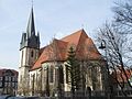
- All Saints Churchat Steinweg was built in the late 13th century and has been a museum since 1989.
- St. Anthony's Chapelat Holzstraße was built in the 13th century and is a hostel today.
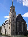
- Corn Market Churchat Kornmarkt was built as a Franciscanian monastery c. 1250. The monastery was abandoned in 1568. In 1702–22 the church was redesigned in thebaroque style.The last service was held here in 1802 after which the church became a warehouse. Since 1975 it has been used as a museum.[4]: 203
- St. James's Churchat Jakobistraße was built in the 14th century and hosts the city library today.
- St. Kilian's Churchat Kiliansgraben was built during the 14th/15th century and hosts a theatre today.
- St. Peter and Paul's Churchbetween Steinweg and Mönchgasse was the church of the Dominican monastery, built in the early 14th century and demolished after a fire in 1689. Today, there are only a few walls remaining.
-
 St. Blaise's Church
 -
 St. Mary's Church
 -
 All Saints Church
 -
 Corn Market Church
 -
 St. James's Church
 -
 St. Kilian's Church


Outside the inner city walls
edit- St. George's Churchat Sondershäuser Straße was built in the 14th century and is a Protestant parish church today.
- St. Martin's Churchat Kiliansgraben was built in the 14th century and is a Protestant parish church today.
- St. Nicholas' Churchat Bastmarkt is a Protestant parish church and was built in the early 14th century in Gothic style as the largest church outside the inner city walls.
- St. Peter's Churchat Petristeinweg was built between 1352 and 1356 and is a Protestant parish church today.
- St. Boniface's Churchat Blobach was built in 1851 inGothic Revival styleand hosts a Catholic kindergarten today.
- St. Joseph's Churchat Karl-Marx-Straße was built in 1903/04 in Gothic Revival style. Today, it is the Catholic parish church.
-
 St. George's Church
 -
 St. Martin's Church
 -
 St. Nicholas' Church
 -
 St. Peter's Church
 -
 St. Joseph's Church
 -
 St. Boniface's Church


Synagogue
editThe Mühlhausen Synagogue at Jüdenstraße was first mentioned in 1380. Today's building is of younger origin: it was established in 1840/41 after theemancipation of the JewsinPrussia.The Synagogue was damaged during the pogrom ofKristallnachtin 1938, but it was one of only a few in Germany that survived theNaziperiod andWorld War II.In 1998, it was reconsecrated and it is in use by the Jewish Community of Thuringia. It is also open for visitors.
Secular buildings
edit
- Theinner city wallswere built during the 12th century with a length of 2.7 kilometres (1.7 mi), a height of 8 metres (26 ft) and a thickness of 1.75 metres (5.7 ft). They are mostly intact, with the exception of most of the gates, laid down during the 19th century to improve traffic access. The only existing gates are theFrauentorin the west (inner and outer one), out of an original total of 23 gates. Next to the inner Frauentor stands theRabenturm,which is accessible via theWehrgang-Museum.
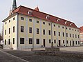
- TheRathaus(town hall) at Ratsstraße is unusual, because it is not located in a square, not even on a main street but more inside a city block. It stretches across Ratsstraße with an arch. It was built after 1310 and several times expanded on until 1596.[4]: 203
- TheBrotlaube(bread storage) is a large building at Obermarkt, first mentioned in 1304 and rebuilt after a fire in 1689. It was the market hall of the bakers. The façade mainly dates to 1722.[4]: 204
- The Order of the Teutonic Knights had two courts in Mühlhausen. The one in the old town at Untermarkt was rebuilt in 1720 and hosts the superintendenture today. The one in the new town next to St. Mary's Church was rebuilt during the 16th century. It was the residence of Thomas Müntzer and later the birthplace ofFriedrich August Stüler.
- ThePfafferode Hospitalis a large hospital complex within a park, built between 1910 and 1917 at the western edge of the city and is a typical example of the early-20th-century sanatorium architecture in Germany.
- TheBrunnenhaus Popperodeis a smallRenaissancebuilding in the south-western periphery of Mühlhausen, built in 1614. The well was first mentioned in 1199 as part of the Medieval city's water supply.[4]: 204
- There are also many architecturally interesting citizens' and patricians' houses within the centre of Mühlhausen, especially along the Steinweg street and at the Untermarkt square.
-
 Inner city walls with theFrauentoron the right and theRabenturmon the left
 -
 Town hall
 -
 Brotlaube
 -
 Court of the Teutonic Knights in the new town
 -
 Some citizens' houses at Untermarkt
 -
 Smaller houses at Holzstraße


Economy and infrastructure
editDuring recent years, the economic situation of the city has improved: the unemployment rate in the Unstrut-Hainich district declined from 21% in 2005 to 10% in 2013 with higher rates in the city than in the bordering rural municipalities. Still, Mühlhausen itself has one of the highest unemployment rates in Thuringia.
Agriculture, industry and services
edit
Agriculture still plays an important role in the Mühlhausen region today. Approximately 55% of the municipal territory is in agricultural use, mostly for growing cereals and vegetables. The region is a centre of the food industry in Germany, especially in the production of conserves likepickles,sauerkraut,apple sauce,cherries and other fruits and vegetables. A well-known product is theMühlhäuser Pflaumenmus(Mühlhausian plum jam), which has been produced here since 1908.
Production of textiles, machines and electrical engineering were major manufacturing industries in Mühlhausen. Nevertheless, most factories were closed after German reunification in 1990. Since that time, Mühlhausen has had some problems finding a new economic core. Compared to other cities in Thuringia, the economic situation is relatively poor. In 2012, there were only 23 companies with more than 20 workers in the industrial sector, employing a total of 1,800 persons and generating an annual turnover of €314 million.[11]
As district capital, Mühlhausen is a regional service hub in retail, health care, cinemas, education, government etc. One of the largest employers was theBundeswehr,but the closure of the barracks in 2015 lead to a loss of more than 800 jobs in the city. Tourism does not play an important role yet, although the city has many historic sights and theHainich National Parkis only 15 km (9 mi) away. In 2012, there were 52,000 overnight visitors staying for a total of 118,000 nights in Mühlhausen.[12]
Transport
edit

Mühlhausen is connected to the railway by astationat the Gotha–Leinefelde line, opened in 1870. There are some regional express trains toGöttingenand toZwickau/Glauchau(viaGotha,Erfurt,Weimar,JenaandGera) running every two hours and some local trains toLeinefeldeand Erfurt (unlike the express viaKühnhausen), running every one to two hours. Former local railway connections toSondershausenin the east andTreffurtin the west were discontinued.
Mühlhausen is the largest city in Thuringia without a direct connection to theAutobahn.TheBundesautobahn 4nearEisenachis 30 km (19 mi) to the south and theBundesautobahn 38nearLeinefeldeis 30 km (19 mi) to the north. The connection to the city is via theBundesstraße 247(which is the most important route) to Leinefelde in the north andBad Langensalza(with further connection to Erfurt and Gotha) in the south, theBundesstraße 249toEschwegein the west andSondershausenin the east and secondary roads toBleicherodein the north, Eisenach in the south andKüllstedtin the north-west. Municipal traffic is mainly via the ring road along the inner city walls, where the load is high on the eastern side at Kiliansgraben. Therefore, a bypass road east around Mühlhausen is in planning to keep the transit traffic out of the city. This is part of a larger set of measures to improve the connections of Mühlhausen by extending the B 247 between Leinefelde, Mühlhausen and Bad Langensalza.
The next local airport is theErfurt-Weimar Airport,approximately 60 km (37 mi) to the south-east and the next major airport is theFrankfurt Airport,approximately 230 km (143 mi) to the south-west.
Biking is getting more and more popular since the construction of quality cycle tracks began in the 1990s. TheUnstrut Trailand theUnstrut-Werra Trailare long-distance biking trails. Both connect points of touristic interest, the former along theUnstrutriver from theEichsfeldnorth-west of Mühlhausen to theSaaleriver nearNaumburg,the latter on an abandoned railway track through the Hainich hills from Mühlhausen toTreffurtin theWerravalley.
The Mühlhausen tramway network was established in 1898 and discontinued in 1969. Since that time, there has been a bus network for local transport within the city and to neighbouring communities.
Education
editThere are twoGymnasiumsin Mühlhausen: one state-run and one Protestant. There was a school of education in Mühlhausen until 1990, when it was merged into the laterUniversity of Erfurt.
Politics
editMayor and city council
editThe first freely elected mayor after German reunification wasHans-Dieter Dörbaum,who served from 1990 to 2012. Since 2012,Johannes Brunsof theSocial Democratic Party(SPD) has been mayor. The most recent mayoral election was held on 15 April 2018, and the results were as follows:
| Candidate | Party | Votes | % | |
|---|---|---|---|---|
| Johannes Bruns | Social Democratic Party | 6,917 | 62.7 | |
| Ines Goldmann | Christian Democratic Union | 2,042 | 18.5 | |
| Charlott Zitschke | Independent | 1,489 | 13.5 | |
| Björn Kirchner | Independent | 576 | 5.2 | |
| Valid votes | 11,024 | 98.6 | ||
| Invalid votes | 155 | 1.4 | ||
| Total | 11,179 | 100.0 | ||
| Electorate/voter turnout | 27,957 | 40.0 | ||
| Source:Wahlen in Thüringen | ||||
The most recent city council election was held on 26 May 2019, and the results were as follows:
| Party | Lead candidate | Votes | % | +/- | Seats | +/- | |
|---|---|---|---|---|---|---|---|
| Christian Democratic Union(CDU) | Volker Bade | 8,453 | 18.7 | 7 | ±0 | ||
| Citizens' List for Mühlhausen | Stefan Sippel | 8,266 | 18.3 | 7 | |||
| Social Democratic Party(SPD) | René Seyfert | 7,158 | 15.8 | 6 | |||
| Alternative for Germany(AfD) | Ronny Hermann Poppner | 6,806 | 15.1 | New | 5 | New | |
| The Left(Die Linke) | Steffen Thormann | 5,504 | 12.2 | 4 | |||
| Alliance 90/The Greens(Grüne) | Micha Hofmann | 3,827 | 8.5 | 3 | |||
| Free Voters(FW) | Thomas Ahke | 3,678 | 8.1 | New | 3 | New | |
| Free Democratic Party(FDP) | Bastian Boelecke | 1,527 | 3.4 | 1 | |||
| Valid votes | 15,206 | 97.6 | |||||
| Invalid votes | 373 | 2.4 | |||||
| Total | 15,579 | 100.0 | 36 | ±0 | |||
| Electorate/voter turnout | 30,268 | 51.5 | |||||
| Source:Wahlen in Thüringen | |||||||
Twin towns – sister cities
editNotable people
edit
- Yom-Tov Lipmann-Muhlhausen(? – after 1420), 14th centuryTalmudist
- Joachim von Burck(1546–1610), composer
- Johannes Eccard(1553–1611), composer andkapellmeister
- Wilhelm Gottlieb Tilesius von Tilenau(1769–1857), scientist, doctor, draftsman and member of the first Russian sailing expedition around the world
- John Adolphus Etzler(1791–1846?), American author, socialist theorist
- Friedrich August Stüler(1800–1865), architect
- John (Johann) August Roebling(1806–1869), civil engineer famous for the design of theBrooklyn Bridge
- Wilhelm Gerhard Walpers(1816–1853), botanist
- Adolph Methfessel(1807–1878), composer
- Ernst Methfessel(1811–1886), composer
- Paul Mankiewitz(1857–1924), bank manager
- Günter Fromm(1926–1994), author
- Werner Leich(1927–2022), Lutheran bishop
References
edit- ^Gewählte Bürgermeister - aktuelle Landesübersicht,Freistaat Thüringen. Retrieved 25 June 2024.
- ^"Bevölkerung der Gemeinden, erfüllenden Gemeinden und Verwaltungsgemeinschaften in Thüringen Gebietsstand: 31.12.2022"(in German).Thüringer Landesamt für Statistik.June 2023.
- ^abcdefgKlauß, Jochen (2009).Thüringen – Literarische Streifzüge (German).Artemis & Winkler (Patmos).ISBN978-3-538-07280-0.
- ^abcdefghijklmnopStahn, Dina (2009).Thüringen (German).Karl Baedeker Verlag.ISBN978-3-8297-1175-3.
- ^"Klima Mühlhausen – Klimatabelle und Beste Reisezeit".klima.org.Archivedfrom the original on 26 September 2020.Retrieved4 December2019.
- ^"Einwohnerstatistik für Mühlhausen und seine Ortsteile"[Population figures of Mühlhausen and its villages] (in German). Stadt Mühlhausen.Archivedfrom the original on 19 March 2022.Retrieved15 May2022.
- ^"Gesetz- und Verordnungsblatt für den Freistaat Thüringen, Nr. 14, 2018"[Law and Ordinance Gazette for the Free State of Thuringia, No. 14, 2018](PDF)(in German). Thüringer Landtag. 28 December 2018. p. 804, § 35.Retrieved15 May2022.
- ^"Thüringer Gesetz- und Verordnungsblatt Nr. 26/2022"(PDF).20 December 2022. p. 475.Archived(PDF)from the original on 15 June 2024.Retrieved10 January2023.
- ^Thüringer Gesetz zur freiwilligen Neugliederung kreisangehöriger Gemeinden im Jahr 2024Archived15 June 2024 at theWayback Machine,Gesetz- und Verordnungsblatt für den Freistaat Thüringen, 2023 Nr. 15, p. 348
- ^"Thüringer Landesamt für Statistik".Archivedfrom the original on 12 October 2013.Retrieved24 October2013.
- ^"Thüringer Landesamt für Statistik".Archivedfrom the original on 6 October 2014.Retrieved24 October2013.
- ^"Thüringer Landesamt für Statistik".Archivedfrom the original on 29 October 2013.Retrieved24 October2013.
- ^"Partnerstädte".muehlhausen.de(in German). Mühlhausen/Thüringen.Archivedfrom the original on 22 June 2020.Retrieved25 February2021.
External links
edit- .Encyclopædia Britannica.Vol. 18 (11th ed.). 1911. p. 957.
- .Collier's New Encyclopedia.1921.