You can helpexpand this article with text translated fromthe corresponding articlein Japanese.(February 2022)Click [show] for important translation instructions.
|
Niigata(Tân tả thị,Niigata-shi,[niːɡata])is a city located in the northern part ofNiigata Prefecture(Kaetsu area). It is the capital and the most populouscityofNiigata Prefecture,and one of thecities designated by government ordinance of Japan,located in theChūbu regionofJapan.It is the most populous city on the west coast ofHonshu,and the second populous city in Chūbu region afterNagoya.It faces theSea of JapanandSado Island.As of 1 September 2022[update],the city had an estimated population of 779,049, and apopulation densityof 1,072 persons per km2.The total area is 726.45 square kilometres (280.48 sq mi). Greater Niigata, the NiigataMetropolitan Employment Area,has a GDP of US$43.3 billion as of 2010.[2][3]
Niigata
Tân tả thị | |
|---|---|
| Niigata City | |
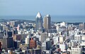
From top left: Niigata skylines fromToki Messe,Bandai Bridge,Former Niigata Customs House,Minatopia,Niigata Prefectural Government Memorial Hall,Furumachiarea,Bandai City | |
 Flag  Seal | |
 | |
 Location of Niigata in Niigata Prefecture | |
 Niigata | |
| Coordinates:37°54′58″N139°2′11″E/ 37.91611°N 139.03639°E | |
| Country | Japan |
| Region | Chūbu(Kōshin'etsu) (Hokuriku) |
| Prefecture | Niigata |
| City Status | April 1, 1889[citation needed]city incorporation) |
| Government | |
| • Mayor | Yaichi Nakahara (from November, 2018) |
| Area | |
| 726.45 km2(280.48 sq mi) | |
| Population (July 1, 2019) | |
| 797,591 | |
| • Density | 1,100/km2(2,800/sq mi) |
| •Metro [1](2015) | 1,060,013 (17th) |
| Time zone | UTC+9(Japan Standard Time) |
| Phone number | 025-243-4894 |
| Address | 1-602-1 Gakkōchō-dōri, Chūō-ku, Niigata-shi, Niigata-ken 951-8550 |
| Climate | Cfa |
| Website | city.niigata.lg.jp |
| Symbols | |
| Bird | Swan |
| Flower | Tulip |
| Tree | Willow |


| Niigata | |||||
|---|---|---|---|---|---|
"Niigata" inkanji | |||||
| Japanese name | |||||
| Kanji | Tân tả | ||||
| |||||
It is the only government-designated city on the west coast of Honshu. It has the greatest habitable area of cities in Japan (list of Japanese cities by area). It is designated as a reform base for the large scale agriculture under (National Strategic Special Zones of Japan) initiatives.
Overview
editNiigata was one of the cities incorporated by the legislation effective on April 1, 1889 (Meiji 22). With a long history as a port town, Niigata served the function of the network junction between the maritime traffic and those of Shinano and Agano river systems. It was designated as one of the five freetreaty portsunder theTreaty of Amity and Commercebetween the United States and Japan, signed in 1858, just before theMeiji Restoration,and later started operations in 1869. Its importance in land and water transportation is still current.
Niigata's city government was established in 1889. Mergers with nearby municipalities in 2005 allowed the city's population to jump to 810,000. The annexation of the surrounding area has also given the city the greatest ricepaddy fieldacreage in Japan. On April 1, 2007, it became the firstgovernment-designated cityon the coast of the Sea of Japan of Honshu. There are eightwards(described later) in the city.
Until the 1950s, a system of canals were lined along by the willow trees in the downtown area of Niigata. Therefore the city is sometimes called the "City of Water" or "City of Willows" asdetailed later.Niigata produced many manga artists (see:Artists and writers). It is also known to have an extensive network ofbypass roads.Bandai bridge, NEXT21, Toki Messe, Denka Big Swan Stadium, Niigata Nippo Media Ship are considered to be the key symbol landmarks in the city (see:Local attractions).
Toponymy
editThe place name "Niigata" was first recorded in 1520 (Eisho 17).[4]Its name inkanjican be translated asTân"new" andTả"lagoon".
However, as there is no record about the origin of the name, this had led to many theories.
- First "Niigata" was a large lagoon at the mouth of the Shinano river.
- Second it was an inland bay at the river's entrance.
- Third it was the name of a village that stood on an island within the estuary.
- Fourth it referred to another settlement that relocated to theFurumachi districtand that in turn gave its name to a nearby lagoon.[5]
Cityscapes
edit
-
 CBDof Niigata City (2012)
 -

-
 Toki Messe(2021)
 -
 River Front Park (2021)
 -
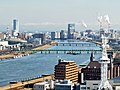 A view of Niigata City andShinano Riverfrom observation deck ofNiigata PrefectureBuilding (2022)
 -
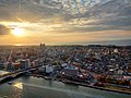 Sunsetof Niigata City (2022)


Geography
editNiigata is situated on a fertilecoastal plainon theSea of Japancoast, facingSado Island.TheShinano RiverandAgano Riverflow through the city.
Numerous wetlands, such as the Fukushimagata wetlands, can be found within the city limits. The Sakata lagoon is registered as a wetland of international importance under theRamsar Convention.
Niigata City's low elevation and abundant water have made flood control and land reclamation important issues for the area throughout its history.
The city is sometimes called the "City of Water"(Thủy の đô,Mizu-no-miyako)because of the two rivers that flow through it, its position next to the Sea of Japan, its many wetlands, and the canals that used to run through the city. It is also sometimes referred to as the "City of Willows"(Liễu の đô,Yanagi-no-miyako)orRyuto(Liễu đô)because of the willow trees that lined the old canals. In recent years, the city has been promoting itself as a "Designated City of Food and Flowers"(Thực と hoa の chính lệnh thị,Shoku to hana no seireishi),highlighting its agricultural areas outside of the city center.
-
 Aerial photo of Niigata
 -
![View of Echigo Plain from Mount Kakuda [ja]](https://upload.wikimedia.org/wikipedia/commons/thumb/c/c6/Echigo-plain.jpg/120px-Echigo-plain.jpg) View ofEchigo PlainfromMount Kakuda
View ofEchigo PlainfromMount Kakuda -
 Lake Fukushimagata
 -
 Lake Sakata

![View of Echigo Plain from Mount Kakuda [ja]](/translate/en.m.wikipedia.org?u=https%3A%2F%2Fen.m.wikipedia.org%2Fwiki%2FFile%3AEchigo-plain.jpg&t=hv)


Climate
editNiigata City features ahumid subtropical climate(Cfa). However, due to high precipitation, it receives more yearly snowfall than cities with continental climates such as Moscow, Montreal or Oslo. Winters are characterized by their high humidity and strong winds from the Sea of Japan. While many other parts of Niigata Prefecture tend to have heavy snow, Niigata City itself usually receives less due to its low-lying elevation and the shielding effect ofSado Island.
On average, Niigata City has 269 days of precipitation each year, about 170 days of which see rain or snowfall measuring over 1 mm.[6]Therainy seasonin July brings large amounts of rain, while the winter months, especially November and December, also have much precipitation.[7]
In summer, the south wind makes the weather rather hot.[citation needed]Typhoonsusually bring strongfoehn windsto this area, generally causing somewhat higher temperatures than in other parts of Japan.[citation needed]The weather on the west coast of Honshu tends to be better during the summer months than on the Pacific coast.[citation needed]
| Climate data for Niigata (1991−2020 normals, extremes 1881−present) | |||||||||||||
|---|---|---|---|---|---|---|---|---|---|---|---|---|---|
| Month | Jan | Feb | Mar | Apr | May | Jun | Jul | Aug | Sep | Oct | Nov | Dec | Year |
| Record high °C (°F) | 15.3 (59.5) |
21.3 (70.3) |
25.1 (77.2) |
30.7 (87.3) |
32.9 (91.2) |
35.0 (95.0) |
38.5 (101.3) |
39.9 (103.8) |
38.8 (101.8) |
33.3 (91.9) |
27.2 (81.0) |
23.6 (74.5) |
39.9 (103.8) |
| Mean daily maximum °C (°F) | 5.3 (41.5) |
6.4 (43.5) |
10.3 (50.5) |
16.1 (61.0) |
21.3 (70.3) |
24.8 (76.6) |
28.7 (83.7) |
30.8 (87.4) |
26.4 (79.5) |
20.7 (69.3) |
14.3 (57.7) |
8.7 (47.7) |
17.8 (64.0) |
| Daily mean °C (°F) | 2.5 (36.5) |
3.1 (37.6) |
6.2 (43.2) |
11.3 (52.3) |
16.7 (62.1) |
20.9 (69.6) |
24.9 (76.8) |
26.5 (79.7) |
22.5 (72.5) |
16.7 (62.1) |
10.5 (50.9) |
5.3 (41.5) |
13.9 (57.0) |
| Mean daily minimum °C (°F) | 0.1 (32.2) |
−0.1 (31.8) |
2.4 (36.3) |
7.0 (44.6) |
12.7 (54.9) |
17.7 (63.9) |
21.8 (71.2) |
23.3 (73.9) |
19.0 (66.2) |
12.8 (55.0) |
6.9 (44.4) |
2.4 (36.3) |
10.5 (50.9) |
| Record low °C (°F) | −11.7 (10.9) |
−13.0 (8.6) |
−6.4 (20.5) |
−2.5 (27.5) |
2.0 (35.6) |
6.7 (44.1) |
11.4 (52.5) |
14.5 (58.1) |
7.9 (46.2) |
3.0 (37.4) |
−1.8 (28.8) |
−9.5 (14.9) |
−13.0 (8.6) |
| Averageprecipitationmm (inches) | 180.9 (7.12) |
115.8 (4.56) |
112.0 (4.41) |
97.2 (3.83) |
94.4 (3.72) |
121.1 (4.77) |
222.3 (8.75) |
163.4 (6.43) |
151.9 (5.98) |
157.7 (6.21) |
203.5 (8.01) |
225.9 (8.89) |
1,845.9 (72.67) |
| Average snowfall cm (inches) | 63 (25) |
48 (19) |
8 (3.1) |
0 (0) |
0 (0) |
0 (0) |
0 (0) |
0 (0) |
0 (0) |
0 (0) |
0 (0) |
19 (7.5) |
139 (55) |
| Average precipitation days(≥ 0.5 mm) | 23.3 | 19.0 | 17.4 | 13.3 | 11.3 | 10.6 | 13.6 | 10.9 | 13.5 | 15.2 | 19.2 | 24.1 | 191.4 |
| Averagerelative humidity(%) | 72 | 74 | 68 | 66 | 69 | 74 | 79 | 75 | 73 | 72 | 74 | 74 | 72 |
| Mean monthlysunshine hours | 56.4 | 74.3 | 136.8 | 177.7 | 202.8 | 179.2 | 162.1 | 205.2 | 156.2 | 138.2 | 91.5 | 62.9 | 1,639.6 |
| Source: Japan Meteorological Agency[8] | |||||||||||||
| Climate data forNishikan-ku[a](1991−2020 normals, extremes 1978−present) | |||||||||||||
|---|---|---|---|---|---|---|---|---|---|---|---|---|---|
| Month | Jan | Feb | Mar | Apr | May | Jun | Jul | Aug | Sep | Oct | Nov | Dec | Year |
| Record high °C (°F) | 14.8 (58.6) |
21.6 (70.9) |
23.2 (73.8) |
29.2 (84.6) |
32.2 (90.0) |
33.2 (91.8) |
36.9 (98.4) |
38.9 (102.0) |
38.6 (101.5) |
32.4 (90.3) |
24.8 (76.6) |
18.9 (66.0) |
38.9 (102.0) |
| Mean daily maximum °C (°F) | 5.2 (41.4) |
5.9 (42.6) |
9.9 (49.8) |
16.0 (60.8) |
21.4 (70.5) |
24.8 (76.6) |
28.3 (82.9) |
30.2 (86.4) |
26.4 (79.5) |
20.4 (68.7) |
14.2 (57.6) |
8.2 (46.8) |
17.6 (63.6) |
| Daily mean °C (°F) | 2.1 (35.8) |
2.2 (36.0) |
5.3 (41.5) |
10.7 (51.3) |
16.4 (61.5) |
20.4 (68.7) |
24.3 (75.7) |
25.6 (78.1) |
21.6 (70.9) |
15.6 (60.1) |
9.7 (49.5) |
4.6 (40.3) |
13.2 (55.8) |
| Mean daily minimum °C (°F) | −0.7 (30.7) |
−1.1 (30.0) |
1.0 (33.8) |
5.6 (42.1) |
12.1 (53.8) |
16.8 (62.2) |
21.0 (69.8) |
21.9 (71.4) |
17.7 (63.9) |
11.2 (52.2) |
5.6 (42.1) |
1.4 (34.5) |
9.4 (48.9) |
| Record low °C (°F) | −13.1 (8.4) |
−12.0 (10.4) |
−7.5 (18.5) |
−3.2 (26.2) |
4.0 (39.2) |
8.8 (47.8) |
13.4 (56.1) |
12.7 (54.9) |
7.1 (44.8) |
1.8 (35.2) |
−5.4 (22.3) |
−12.2 (10.0) |
−13.1 (8.4) |
| Averageprecipitationmm (inches) | 165.2 (6.50) |
99.8 (3.93) |
99.9 (3.93) |
90.9 (3.58) |
85.2 (3.35) |
117.0 (4.61) |
213.3 (8.40) |
154.2 (6.07) |
130.4 (5.13) |
136.1 (5.36) |
190.2 (7.49) |
222.8 (8.77) |
1,704.1 (67.09) |
| Average precipitation days(≥ 1.0 mm) | 20.1 | 16.2 | 15.9 | 11.8 | 10.3 | 9.9 | 12.5 | 10.1 | 11.7 | 13.6 | 17.5 | 20.6 | 170.2 |
| Mean monthlysunshine hours | 47.9 | 71.2 | 129.9 | 171.5 | 195.0 | 174.9 | 157.8 | 182.4 | 139.1 | 126.0 | 85.4 | 49.6 | 1,530.7 |
| Source:Japan Meteorological Agency[9][10] | |||||||||||||
Wards
editNiigata has a system ofwards(ku) since April 1, 2007:[11]Each ward has its own "image color".
| Wards of Niigata | ||||
|---|---|---|---|---|
| Place Name | Map of Niigata | |||
| Rōmaji | Kanji | Color | ||
| 1 | Akiha Ward | Thu diệp khu | ■Floral green |  |
| 2 | Chuo Ward(administrative center) | Trung ương khu | ■Waterfront blue | |
| 3 | Higashi Ward | Đông khu | ■Aqua blue | |
| 4 | Kita Ward | Bắc khu | ■Nature green | |
| 5 | Konan Ward | Giang nam khu | ■Spring green | |
| 6 | Minami Ward | Nam khu | ■Breeze blue | |
| 7 | Nishi Ward | Tây khu | ■Sunset orange | |
| 8 | Nishikan Ward | Tây bồ khu | ■Harvest yellow | |

Adjoining communities
editFrom the north, following Niigata's borderclockwise:
- In additionSado Islandis connected by sea and air routes.
History
editPrehistoric and ancient
editPeople have inhabited the Niigata area (Furutsu Hachimanyama Site) since theJōmon period,though much of the current land was still beneath the sea at the time. According to theNihon Shoki,a fortress was built in the area in AD 647.

Feudal period
editIn the 16th century, a port called Niigata was established at the mouth of theShinano River,while a port town with the name Nuttari developed at the mouth of theAgano River.The area prospered beneath the rule ofUesugi Kenshinduring theSengoku Period.
Early modern ages
editA system of canals was constructed throughout the downtown area of Niigata port in the 17th century.[12]During this period, the courses of the Shinano and Agano rivers gradually changed until they poured into the Sea of Japan at the same location. As a result, Niigata prospered as a port town, serving as a port of call for Japanese trade ships traversing the Sea of Japan.
The Matsugasaki Canal was constructed in 1730 to drain the Agano River area, but in 1731, flooding destroyed the canal and caused it to become the main current of the Agano River. As a result, the volume of water flowing into the port of Niigata decreased, which in turn allowed land reclamation efforts and the development of new rice fields to proceed.
- Gallery
-
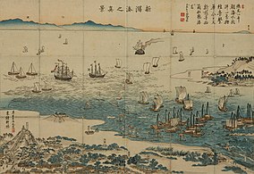 Nishiki-e "Niigata Minato no Shinkei" (View of Niigata Port), 1859
 -
 Niigata drawn by Utagawa Hiroshige in 1859


Late modern ages
editIn 1858, Niigata was designated as one of the five ports to be opened for international trade in theJapan–U.S. Treaty of Amity and Commerce.However, the shallow water level in the port delayed the actual opening to foreign ships until 1869. The port also served as a valuable base for fishermen who roamed as far north as theKamchatka Peninsulato catch salmon and other fish.
In 1886, the firstBandai Bridgewas built across the Shinano River to connect the settlements of Niigata on the west and Nuttari on the east. Niigata annexed Nuttari in 1914.
DuringWorld War II,Niigata's strategic location between the capital ofTokyoand the Sea of Japan made it a key point for the transfer of settlers and military personnel to the Asian continent, includingManchukuo.
- Gallery
-
 Niigata City History Museum(Minatopia)
 -
 Old Niigata Customs Government Building
 -
 Former Daishi Bank Sumiyoshi-cho Branch
 -


Contemporary ages
editIn 1945, near the end of the war, Niigata was one of four cities, together with Hiroshima, Kokura, and Nagasaki, picked as targets forthe atomic bombsif Japan did not surrender. However, Niigata was not actually targeted in the first two missions. There were several theories about the reasons that Niigata was lowered in the priority, such as poor weather conditions, its distance from B-29 bases in the Mariana Islands, and other factors.[13]
On August 11, 1945, after the second atomic bombing in Nagasaki, the governor of Niigata Prefecture ordered the people to evacuate as concerns of an impending bombing heightened, and the city was completely deserted for days until the war ended without more atomic bombings.[14]
A devastatingTyphoon Louiseand fire in 1955 destroyed much of the downtown area, but eventually the city recovered. In 1958, construction of the relocatedNiigata Stationwas completed, extending the downtown area from Bandai Bridge. TheNiigata Thermal Power StationUnit 1 started operation in July 1963. At that time, it was Japan's first power plant capable of using a mixture of natural gas and heavy oil.
In 1964, the old canals that flowed throughout the old downtown area were filled in to make way for more roads and due to sanitation concerns. The flow through the canals had decreased over the years and the rate at which waste was carried out through them was not fast enough. In addition, they became mosquito breeding grounds during the summer.
On June 16, 1964, at 13:01Japan Standard Timean earthquake of 7.5Richter scalestruck the city, killing 29 people and causing large-scale property damage, with 1,960 totally destroyed buildings, 6,640 partially destroyed buildings, and 15,298 severely inundated byliquefaction.
In 1965, theAgano Riverrunning through Niigata was polluted withmethylmercuryfrom the chemical plant of theShowa Electrical Company.Over 690 people exhibited symptoms ofMinamata diseaseand the outbreak became known asNiigata Minamata disease.
- Gallery
-
 Niitsu Oil Field(1930s)
 -
 The 1955 fire of Niigata
 -
 Some effects ofliquefactionduring the1964 Niigata earthquake


In 1982,Shinkansenservice on theJōetsu Shinkansenline began between Niigata andOmiya,with service toUenoadded in 1985. The line was extended to Tokyo in 1991.
Big Swan Stadiumin Niigata City hosted three games during the2002 FIFA World Cup.
The2004 Chūetsu earthquakedid not cause any significant damage in Niigata City itself, allowing the city to work as a relief base.
The size and the population of Niigata city increased over the four-year period between 2001 and 2005, due to a series ofmunicipal mergers.On April 1, 2007, Niigata City became first city on the west coast of Honshu to become agovernment-designated city.
In July 2007, theChūetsu offshore earthquake,measuring 6.9 on Richter scale, rocked Niigata Prefecture. Though the earthquake was felt in the city, there was little damage, which allowed Niigata City to provide aid to the devastated areas.
In May 2008, the city hosted the2008 G8 Labor Ministers Meeting.
On March 12, 2011, several hours after the massive 9.0 Tohoku earthquake struck off the east coast of Honshu, Niigata and Nagano Prefectures experienced an estimated magnitude 6.6 earthquake.
Mergers
edit
- On April 1, 1889 - The village of Sekiya was merged into the town of Niigata to become the city of Niigata.
- On April 1, 1914 - The town of Nuttari (fromNakakanbara District) was merged into the city of Niigata.
- On June 1, 1943 - The village of Ohgata (fromNakakanbara District) was merged into the city of Niigata.
- On December 8, 1943 - The villages of Ishiyama and Toyano (both fromNakakanbara District) were merged into the city of Niigata.
- On April 5, 1954 - The village of Matsugasakihama (fromKitakanbara District) was merged into the city of Niigata.
- On November 1, 1954 - The villages of Nigorikawa and Minamihama (both fromKitakanbara District) and the village of Sakaiwa (fromNishikanbara District) were merged into the city of Niigata.
- On May 3, 1957 - The villages of Ryokawa, Sonoki and Oheyama (all fromNakakanbara District) were merged into the city of Niigata.
- On January 11, 1960 - The town of Uchino (fromNishikanbara District) was merged into the city of Niigata.
- On April 1, 1960 - The Hamaura hamlet of the town ofToyosaka(fromKitakanbara District) was merged into the city of Niigata.
- On June 1, 1961 - The villages of Nakanokoya and Akatsuka (both fromNishikanbara District) were merged into the city of Niigata.
- On January 1, 2001 - The town ofKurosaki(fromNishikanbara District) was merged into the city of Niigata.
- On March 21, 2005 - The cities ofNiitsu,ShironeandToyosaka,the towns ofKameda,KosudoandYokogoshi(all fromNakakanbara District), the town ofNishikawa,and the villages ofAjikata,Iwamuro,Katahigashi,NakanokuchiandTsukigata(all fromNishikanbara District) were all merged into the expanded city of Niigata.[15]
- On October 10, 2005 - The town ofMaki(fromNishikanbara District) was merged into the expanded city of Niigata.
Government
editCity Hall
edit- List of mayors of Niigata City (1889 to present)
|
|
|
International relations
editSister cities
editNiigata maintainssister cityties with six cities:
| City | Country | State | Since |
|---|---|---|---|
| Galveston | Texas | January 28, 1965 | |
| Khabarovsk | Khabarovsk Krai | April 23, 1965 | |
| Vladivostok | Primorsky Krai | February 28, 1991 | |
| Birobidzhan | Jewish Autonomous Oblast | August 6, 1992 (once a sister city ofToyosaka,Niigata assumed the sister city honors in 2005) | |
| Nantes | Pays de la Loire | January 31, 2009 (shifted from friendship city since 1999) |
Friendship cities
edit| City | Country | State | since |
|---|---|---|---|
| Harbin | Heilongjiang | December 17, 1979 |
Partnership cities
editIn addition, special exchange agreements have been set up with the following:[citation needed]
 Kingston upon Hull,United Kingdom
 Ulsan,South Korea (since September 2007)
National
edit| City | Prefecture | region | Since |
|---|---|---|---|
| Hakodate | Hokkaidō region | 1993 (Treaty ports Partnership) | |
| Yokohama | Kantō region | 1993 (Treaty ports Partnership) | |
| Kobe | Kansai region | 1993 (Treaty ports Partnership) | |
| Nagasaki | Kyushu region | 1993 (Treaty ports Partnership) | |
| Sado | Chūbu region | August 1, 2008 | |
| Aizuwakamatsu | Tōhoku region | July 22, 2012 | |
| Kyoto | Kansai region | March 26, 2013 |
Education
edit
Colleges and universities
edit- Niigata University
- University of Niigata Prefecture
- Niigata Seiryo University
- The Nippon Dental UniversitySchool of Life Dentistry at Niigata
- Niigata University of Pharmacy and Applied Life Sciences
- International University of Japan
- Niigata University of International and Information Studies
- Niigata University of Health and Welfare
- Graduate Institute for Entrepreneurial Studies
- College of Biomedical Technology Niigata University
- Niigata Agro-Food University
Transportation
edit


Airways
editAirport
editNiigata Airportis located about 6 km north of central Niigata. It handles some international destinations as well as many domestic ones. As of October 2016, the domestic destinations available areOsaka(10 times a day),Sapporo(five or six times a day),Fukuoka(three times a day),Okinawa(once or twice a day),Nagoya(three times a day),Narita(once a day) andSado Island(three times a day).
Niigata Airport's international destinations areHarbin(twice a week),Seoul(five times a week),Shanghai(twice a week) andVladivostok.[16]
Railways
editThe largest station in Niigata City isNiigata Station.It is centrally located in the Bandai area, one of the two main shopping districts in downtown Niigata. Approximately 37,000 passengers use the station daily. TheJōetsu Shinkansen,which terminates at Niigata Station, provides daily service to Tokyo. TheShin'etsu Main Line,Hakushin Line,Echigo Line,Uetsu Main Line,andBan'etsu West Linealso terminate at Niigata Station. These lines serveMyoko,Itoigawa,Akita,Sakata,andAizuwakamatsu.
Niigata Kotsu Dentetsu Line and Kambara Dentetsu trains used to run through the city until the late 1990s; however, they no longer exist.
High-speed rail
edit- East Japan Railway Company(JR East)
Conventional lines
edit- East Japan Railway Company(JR East)
- Shin'etsu Main Line:-Niigata-Echigo-Ishiyama-Kameda-Ogikawa-Satsukino-Niitsu-Furutsu-Yashiroda
- Hakushin Line:Niigata-Higashi-Niigata-Ōgata-Niizaki-Hayadōri-Toyosaka-Kuroyama
- Echigo Line:Niigata-Hakusan-Sekiya-Aoyama-Kobari-Terao-Niigata University-Uchino-Uchino-Nishigaoka-Echigo-Akatsuka-Echigo-Sone-Maki-Iwamuro-Yoshida
Buses
editTransit Bus
editBRT "Bandai-bashi Line"runs through business/shopping districts in the central Niigata (Niigata Station -Bandai Bridge-Furumachi- City hall -Hakusan Station- Aoyama).
Roads
editExpressways
editJapan National Route
edit National Route 7
 National Route 9
 National Route 49
 National Route 113
 National Route 116
 National Route 289
 National Route 345
 National Route 350
 National Route 402
 National Route 403
 National Route 459
 National Route 460
Seaways
editSea port
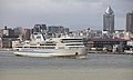
editThe Port of Niigata served as a part ofkitamaebuneduring Edo era, and became one of the five open ports according to theTreaty of Amity and Commerce (United States–Japan)in 1858. The west district of the port of Niigata provides passenger transportation facilities as well as cargo transportation, while the east district is dedicated for cargo capabilities, including the container terminal facilities. The Port of Niigata is designated as one ofthe international hub portsby the government.
The destinations of the passenger services available at the port of Niigata include Ryotsu on Sado island, Otaru, Akita, Tsuruga.
Until 2006, Niigata was formerly theterminusof theMangyongbong-92ferry,one of the direct connections between Japan andNorth Korea.
-

-

-
 Bandai-bashi Line(BRT)
 -
 Port of Niigata


Local attractions
edit- Furumachi,Bandai City- Downtown shopping districts
- Toki Messe,Next21,Niigata Nippo Media Ship,Niigata Prefectural Government Office- skyscrapers with observation decks
- Nuttari Terrace
- Pier Bandai
- Niigata City History Museum(Minatopia)
- Northern Culture Museum
- Marinepia Nihonkai Aquarium
- Fukushimagata Lagoon Park
- Iwamuro Onsen
- Niigata Prefectural Botanical Garden
- Nature Aquarium Gallery[17]


![Nuttari Terrace [ja]](/translate/en.m.wikipedia.org?u=https%3A%2F%2Fen.m.wikipedia.org%2Fwiki%2FFile%3ANuttariterasu2013.jpg&t=hv)
![Fukushimagata Lagoon Park [ja]](/translate/en.m.wikipedia.org?u=https%3A%2F%2Fen.m.wikipedia.org%2Fwiki%2FFile%3AFukushimagata_Lagoon_Kataraitei_002_April2020.jpg&t=hv)
![Iwamuro Onsen [ja]](/translate/en.m.wikipedia.org?u=https%3A%2F%2Fen.m.wikipedia.org%2Fwiki%2FFile%3AIwamuro-onsen%2CNiigata-city%2CNiigata%2CJapan.jpg&t=hv)
Culture
edit
Niigata has its owngeishaculture since over 200 years ago dating back to the Edo period. This was due to the prosperity of the city as a port town. Locally they are calledgeigiand the tradition continues on. Mostochayaare located in the Furumachi neighbourhood with well-known places such as the Nabechaya.[18]
Events
edit- Niigata Festival(every August)
- Kambara Festival
- Niigata Comic Market
- Niigata Manga Competition
- Kurosaki Festival
Foods
edit- TareKatsudon
- Noppe
- Kakinomoto
- Sasa Dango
- MikazukiItalian Noodle
- Assari-Shōyu Ramen


Sports
edit


Notable people from Niigata
editArtists and writers
edit- Yaichi Aizu,poet, calligrapher, and historian
- Koichi Endo.manga artist
- Shu Fujisawa,writer
- Makoto Kobayashi,manga artist
- Mineo Maya,manga artist
- Shinji Mizushima,manga artist
- Tadashi Nakayama,contemporary woodblock artist
- Takeshi Obata,manga artist
- One,manga artist
- Ango Sakaguchi,author
- Rumiko Takahashi,manga artist
Actors and voice actors
edit- Fumika Baba,actress
- Mina Fujii,actress
- Toshihito Ito,actor
- Masashi Mikami,actor
- Bin Shimada,voice actor
- Keiko Yokozawa,voice actor
Musicians
edit- coba,accordionist and composer
- Double,singer
- Yoko Ishida,singer
- Katsutaro Kouta,singer
- Közi,guitarist (Malice MizerandEve of Destiny)
- NGT48,idol group
- samfree,vocaloid music composer
- Rina Sawayama,singer-songwriter and model
- Akira Yamaoka,composer
Others
edit- Takashi Amano,professional aquarist and track cyclist
- Kazuya Kato,mathematician
- Kunio Maekawa,architect
- Yutakayama Ryota,sumo wrestler[19]
- SANADA(Seiya Sanada), professional wrestler
- Tadao Sato,film critic and film theorist
- Megumi Sato,high jumper
- Meiko Satomura,professional wrestler
- Yujiro Takahashi,professional wrestler
- Megumi Yokota,abduction victim[20]
References
edit- ^"UEA Code Tables".Center for Spatial Information Science, University of Tokyo.RetrievedJanuary 26,2019.
- ^Yoshitsugu Kanemoto."Metropolitan Employment Area (MEA) Data".Center for Spatial Information Science, TheUniversity of Tokyo.Archived fromthe originalon 2018-06-15.Retrieved2016-09-29.
- ^Conversion rates - Exchange rates- OECD Data
- ^Tri っておきたい tân tả huyện の lịch sử biên tập ủy viên hội (2010).Tri っておきたい tân tả huyện の lịch sử.Tân tả nhật báo sự nghiệp xã.ISBN978-4861323720.
- ^Giác xuyên nhật bổn địa danh đại từ điển biên toản ủy viên hội (1989).Giác xuyên nhật bổn địa danh đại từ điển 15 tân tả huyện.( chu ) giác xuyên thư điếm.ISBN4-04-001150-3.
- ^Bình niên trị ( niên ・ nguyệt ごとの trị )
- ^Niigata City 2007 Statistical Data,published 2007
- ^Khí tượng sảnh / bình niên trị ( niên ・ nguyệt ごとの trị ).Japan Meteorological Agency.RetrievedMay 19,2021.
- ^Quan trắc sử thượng 1~10 vị の trị ( niên gian を thông じての trị ).JMA.RetrievedMarch 23,2022.
- ^Khí tượng sảnh / bình niên trị ( niên ・ nguyệt ごとの trị ).JMA.RetrievedMarch 23,2022.
- ^MapArchivedSeptember 27, 2007, at theWayback Machine
- ^Phú sơn phú nhất (1991).にいがた sự thủy め.Tân tả nhật báo sự nghiệp xã. pp.150–152.
- ^Neglected Niigata | Restricted Data
- ^Tân tả がゴーストタウンになった nhật. Tri sự が mệnh じた “Nguyên bạo sơ khai” | ハフポスト
- ^Trụ dân cơ bổn đài trướng nhân khẩu di động báo cáo niên báo(in Japanese). Tổng vụ sảnh thống kế cục. 2005. p. 139.
3 nguyệt 21 nhật に bạch căn thị, phong vinh thị, tiểu tu hộ đinh, hoành việt đinh, quy điền đinh, nham thất thôn, tây xuyên đinh, vị phương thôn, tả đông thôn, nguyệt tả thôn, trung chi khẩu thôn cập び tân tân thị は tân tả thị に biên nhập された.
- ^Flight Schedule - NIIGATA AIRPORT
- ^"Nature Aquarium Gallery official website".Archived fromthe originalon 2012-10-16.Retrieved2012-09-18.
- ^"The Niigata Geigi: Japan's 'other' geishas".
- ^"Yutakayama Rikishi Information".Sumo Reference.Retrieved3 May2018.
- ^"North Korea abductee: Japan parents meet grand-daughter - BBC News".BBC News.17 March 2014.Retrieved2015-04-08.
Notes
editExternal links
edit.New International Encyclopedia.1905.
 Niigata (city)travel guide from Wikivoyage
- Official Website(in Japanese)