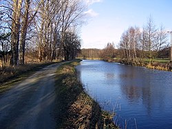
TheOhreis ariverin northernGermany,left tributary to theElbe.Its total length is 103 kilometres (64 mi). Its source is north ofWolfsburg,inLower Saxony.It flows generally south-east, at first following the border of Lower Saxony andSaxony-Anhalt.AfterBuchhorstit flows completely through Saxony-Anhalt, along theMittellandkanal.It flows into the Elbe inRogätz,north ofMagdeburg.The townsBrome,Calvörde,HaldenslebenandWolmirstedtlie along the river. The upper course of the Ohre is in theDrömlingnature reserve.
| Ohre | |
|---|---|
 The Ohre nearCalvörde | |
| Location | |
| Country | Germany |
| States | |
| Physical characteristics | |
| Source | |
| • location | Lower Saxony |
| Mouth | |
• location | Elbe |
• coordinates | 52°18′40″N11°45′55″E/ 52.31111°N 11.76528°E |
| Length | 104.9 km (65.2 mi)[1] |
| Basin size | 1,670 km2(640 sq mi)[1] |
| Basin features | |
| Progression | Elbe→North Sea |
Between the end of theSecond World WarandGerman reunification,the Ohre separatedEastfromWest Germanyand so formed part of theInner German border.
See also
editReferences
edit