You can helpexpand this article with text translated fromthe corresponding articlein French.Click [show] for important translation instructions.
|
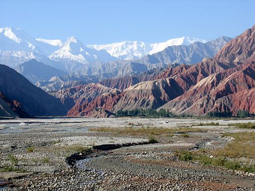
ThePamir Mountainsare arange of mountainsbetweenCentral AsiaandSouth Asia.They are located at a junction with other notable mountains, namely theTian Shan,Karakoram,Kunlun,Hindu Kushand theHimalayamountain ranges. They are among the world's highestmountains.
| Pamir Mountains | |
|---|---|
 Pamir Mountains | |
| Highest point | |
| Peak | Kongur Tagh |
| Elevation | 7,649 m (25,095 ft) |
| Coordinates | 38°35′39″N75°18′48″E/ 38.59417°N 75.31333°E |
| Geography | |

| |
| Countries | Tajikistan,Kyrgyzstan,Afghanistan,China[A]andPakistan |
| States/Provinces | Gorno-Badakhshan,Osh Region,Wakhan,Chitral&Gilgit Baltistan,PakistanandXinjiang[B] |
| Range coordinates | 38°30′N73°30′E/ 38.5°N 73.5°E |
Much of the Pamir Mountains lie in theGorno-Badakhshanregion ofTajikistan.[1]To the south, they border the Hindu Kush mountains alongAfghanistan'sWakhan CorridorinBadakhshan Province,ChitralandGilgit-Baltistanregion ofPakistan.To the north, they join the Tian Shan mountains along theAlay ValleyofKyrgyzstan.To the east, they extend to the range that includesChina'sKongur Tagh,in the "Eastern Pamirs",[2]separated by theYarkandvalley from theKunlun Mountains.

Since theVictorian era,they have been known as the "Roof of the World",presumably a translation fromPersian.[3]
Names and etymology
editIn other languages
editThe Pamir region is home to several different cultures, peoples and languages. In some of these languages, the Pamir Mountains are referred by different names.
InIndo-European languages,they are called:
- پامیر غرونهPāmīr GhrūnainPashto;
- رشته کوههای پامیر,Ришта Кӯҳҳои Помир,Rishta Kūhhoi PomirinTajik;
- پامیر کوهستانPāmīr KohistāninUrdu;
- सुमेरुSumeruinSanskrit.
InTurkic languages,they are called:
- پامىر توولورۇ,Памир Тоолору,Pamir TooloruinKyrgyz;
- پامىر ئېگىزلىكى,Pamir Ëgizliki,Памир ЕгизликиinUyghur.
InChinese,they are referred as "Onion Range" (simplified Chinese:Thông lĩnh;traditional Chinese:Thông lĩnh;pinyin:Cōnglǐng;Wade–Giles:Ts'ung-ling), which is named after thewild onionsgrowing in the region;[4][5]In theDungandialect ofMandarin,it is writtenПамир / Цунлинin theCyrillic alphabet,and inXiao'erjingit is writtenپَامِعَر/ڞوْلٍْ.The name "Pamir" is used more commonly in Modern Chinese and loaned asMạt mễ nhĩ/Mạt mễ nhĩPàmǐ'ěr.
Geological term
editAccording to Middleton and Thomas, "pamir" is also a geological term.[6]A pamir is a flat plateau orU-shaped valleysurrounded by mountains. It forms when a glacier or ice field melts leaving a rocky plain. A pamir lasts until erosion forms soil and cuts down normal valleys. This type of terrain is found in the east and north of theWakhan,[7]and the east and south of Gorno-Badakhshan, as opposed to the valleys and gorges of the west. Pamirs are used for summer pasture.[6][7]
TheGreat Pamiris around LakeZorkul.TheLittle Pamiris east of this in the far east of Wakhan.[7]TheTaghdumbash Pamiris betweenTashkurganand theWakhanwest of theKarakoram Highway.The Alichur Pamir is around Yashil Kul on theGunt River.The Sarez Pamir is around the town ofMurghab, Tajikistan.The Khargush Pamir is south of LakeKarakul.There are several others.
ThePamir Riveris in the south-west of the Pamirs.
Geography
edit-
-
 Slopes of Pamir Mountains on the Chinese side andMuztagh Ata
 -
 Pamir Mountains from a NASA satellite image, April 2012


Mountain
editThe three highest mountains in the Pamirs core areIsmoil Somoni Peak(known from 1932 to 1962 as Stalin Peak, and from 1962 to 1998 as Communism Peak), 7,495 m (24,590 ft);Ibn Sina Peak(still unofficially known as Lenin Peak), 7,134 m (23,406 ft); andPeak Korzhenevskaya(Russian:Пик Корженевской,Pik Korzhenevskoi), 7,105 m (23,310 ft).[8]In the Eastern Pamirs, China'sKongur Taghis the highest at 7,649 m (25,095 ft).
Among the significant peaks of the Pamir Mountains are the following:[9]
Remark:The summits of the Kongur and Muztagata Group are in some sources counted as part of theKunlun,which would make Pik Ismoil Somoni the highest summit of the Pamir.

Glaciers
editThere are manyglaciersin the Pamir Mountains, including the 77 km (48 mi) longFedchenko Glacier,the longest in the formerUSSRand the longest glacier outside thepolar regions.[10]Approximately 12,500 km2(ca. 10%)[11]of the Pamirs are glaciated. Glaciers in the Southern Pamirs are retreating rapidly. Ten percent of annual runoff is supposed to originate from retreating glaciers in the Southern Pamirs.[11]In the North-Western Pamirs, glaciers have almost stablemass balances.[11]
Climate
edit
Covered insnowduring most of the year, the Pamirs have long and bitterly coldwinters,and short, coolsummers,which equals anET (tundra climate)according toKöppen climate classification(EFabove the snow line). Annualprecipitationis about 130 mm (5 in), which supportsgrasslandsbut fewtrees.
Paleoclimatology during the Ice Age
editThe East-Pamir, in the centre of which themassifsof Mustagh Ata (7620 m) and Kongur Tagh (Qungur Shan, 7578, 7628 or 7830 m) are situated, shows from the western margin of the Tarim Basin an east–west extension of c. 200 km. Its north–south extension from King Ata Tagh up to the northwest Kunlun foothills amounts to c.170 km. Whilst the up to 21 km long current valley glaciers are restricted to mountain massifs exceeding 5600 m in height, during the last glacial period the glacier ice covered the high plateau with its set-up highland relief, continuing west of Mustagh Ata and Kongur. From this glacier area an outlet glacier has flowed down to the north-east through the Gez valley up to c.1850 m asl (meters above sea level) and thus as far as to the margin of the Tarim basin. This outlet glacier received inflow from the Kaiayayilak glacier from the Kongur north flank. From the north-adjacent Kara Bak Tor (Chakragil, c. 6800 or 6694 m) massif, the Oytag valley glacier in the same exposition flowed also down up to c. 1850 m asl. At glacial times the glacier snowline (ELA[C]) as altitude limit between glacier nourishing area and ablation zone, was about 820 to 1250 metres lower than it is today.[13][14]Under the condition of comparable proportions of precipitation there results from this a glacial depression of temperature of at least 5 to 7.5 °C.
Economy
editCoalis mined in the west, thoughsheepherding in uppermeadowlandsis the primary source of income for the region.
Exploration
edit
Thelapis lazulifound in Egyptian tombs is thought to come from the Pamir area in Badakhshan province of Afghanistan.[6]About 138 BCEZhang Qianreached theFergana Valleynorthwest of the Pamirs.Ptolemyvaguely describes a trade route through the area. From about 600 CE, Buddhist pilgrims travelled on both sides of the Pamirs to reach India from China. In 747 a Tang army was on the Wakhan River. There are various Arab and Chinese reports.Marco Polomay have travelled along thePanj River.In 1602Bento de Goestravelled fromKabultoYarkandand left a meager report on the Pamirs. In 1838 LieutenantJohn Woodreached the headwaters of thePamir River.From about 1868 to 1880, a number of Indians in the British service secretly explored the Panj area. In 1873 the British and Russians agreed to an Afghan frontier along the Panj River. From 1871 to around 1893 several Russian military-scientific expeditions mapped out most of the Pamirs (Alexei Pavlovich Fedchenko,Nikolai Severtzov,CaptainDmitry Putyataand others. Later cameNikolai Korzhenevskiy). Several local groups asked for Russian protection from Afghan raiders. The Russians were followed by a number of non-Russians includingNey Elias,George Littledale,the Earl of Dunmore,Wilhelm FilchnerandLord Curzonwho was probably the first to reach the Wakhan source of theOxus River.In 1891 the Russians informedFrancis Younghusbandthat he was on their territory and later escorted a Lieutenant Davidson out of the area ('Pamir Incident'). In 1892 a battalion of Russians under Mikhail Ionov entered the area and camped near the presentMurghab.In 1893 they built a proper fort there (Pamirskiy Post). In 1895 their base was moved toKhorogfacing the Afghans.
In 1928 the last blank areas around theFedchenko Glacierwere mapped by a German-Soviet expedition under Willi Rickmer Rickmers.
Discoveries
editIn the early 1980s, a deposit ofgemstone-qualityclinohumitewas discovered in the Pamir Mountains. It was the only such deposit known until the discovery of gem-quality material in theTaymyrregion ofSiberia,in 2000.
The earliest known evidence of humancannabisuse was found in tombs at the Jirzankal Cemetery.[15]
Transport
edit
ThePamir Highway,the world's second highest international road, runs fromDushanbeinTajikistantoOshinKyrgyzstanthrough theGorno-Badakhshan Autonomous Province,and is the isolated region's main supply route. The GreatSilk Roadcrossed a number of Pamir Mountain ranges.[16]
Tourism
editIn December 2009, theNew York Timesfeatured articles on the possibilities for tourism in the Pamir area of Tajikistan.[17][18]2013 proved to be the most successful year ever for tourism in the region and tourism development continues to be the fastest growing economic sector.

Strategic position
edit
Historically, the Pamir Mountains were considered a strategic trade route betweenKashgarandKokandon theNorthern Silk Road,a prehistoric trackway, and have been subject to numerous territorial conquests. The Northern Silk Road (about 2,600 km (1,616 mi) in length) connected the ancient Chinese capitalChang'anwith Kashgar over the Pamir Mountains towards the west, and from there continued to ancientParthia.[19]In the 20th century, these mountains have been the setting for theTajikistan Civil War,border disputes betweenChina and the Soviet Union,establishment of military bases by the US, Russia, and India,[20]and renewed interest in trade development and resource exploration.[21][22]The Chinese government says it has resolved most of the disputes it had with Central Asian countries.[23]
Religious symbolism
editSome researchers identify the Pamirs with theMount Meruor Sumeru.[24][25][26][27][28][29][30]The Mount Meru is thesacred five-peaked mountainofBuddhistandJain,and is considered to be the center of all thephysical,metaphysicaland spiritual universes.[31]
See also
editNotes
edit- ^See alsoOne Chinaand thepolitical status of Taiwan.
- ^Also claimed by theRepublic of China on Taiwanas part ofSinkiang Province.
- ^The snow line that separates the snow above from the firn (1 yr old snow) or bare glacier ice below is the equilibrium line altitude (ELA).[12]
References
edit- ^According to theBig Soviet Encyclopedia"The question of the natural boundaries of Pamir is debatable. Normally Pamir is regarded as covering the territory from Trans-Alay Range to the north, Sarykol Range to the east, Lake Zorkul, Pamir River, and the upper reaches of Panj River to the south, and the meridional section of the Panj valley to the west; to the north-west Pamir includes the eastern parts of Peter the Great and Darvaz ranges."
- ^Arnaud, N. O.; Brunel, M.; Cantagrel, J. M.; Tapponnier, P. (1993). "High cooling and denudation rates at Kongur Shan, Eastern Pamir (Xinjiang, China)".Tectonics.12(3): 1335–1346.doi:10.1029/93TC00767.
- ^Bliss, Frank (2002-06-01).Social and Economic Change in the Pamirs (Gorno-Badakhshan, Tajikistan): Translated from German by Nicola Pacult and Sonia Guss with support of Tim Sharp.Taylor & Francis. pp. 13–14.ISBN978-0-203-40531-4.
Pamir = a Persian compilation of pay-I-mehr, the "roof of the world".
- ^Li, Daoyuan.[Commentary on the Water Classic] (in Chinese). Vol. 2 – viaWikisource.
Thông lĩnh tại đôn hoàng tây bát thiên lí, kỳ sơn cao đại, thượng sinh thông, cố viết thông lĩnh dã.(quoting from the "Tây hà cựu sự") The Onion Range is 8,000Liwest ofDunhuanginUzbek Language "Pamir Tog'i". Its mountains are high and onions grow on them, therefore it is called Onion Range.
- ^"The origin of the Chinese name" Onion Range "for Pamir".Depts.washington.edu. 2002-04-14.Retrieved2009-08-10.
- ^abcThis section is based on the book by R. Middleton and H. Thomas: Robert Middleton and Huw Thomas, 'Tajikistan and the High Pamirs', Odyssey Books, 2008
- ^abc"Aga Khan Development Network (2010): Wakhan and the Afghan Pamir"(PDF).p. 3. Archived fromthe original(PDF)on 2011-12-25.
- ^Tajikistan: 15 Years of Independence,statistical yearbook, Dushanbe, 2006, p. 8, in Russian.
- ^"Dominance".www.8000ers.com.Retrieved6 April2010.
- ^In the Karakoram Mountains,Siachen Glacieris 76 km long,Biafo Glacieris 67 km long, andBaltorois 63 km long. TheBruggen or Pio XI Glacierin southern Chile is 66 km long. Kyrgyzstan'sSouth Inylchek (Enylchek) Glacieris 60.5 km in length. Measurements are from recent imagery, generally with Russian 1:200,000 scale topographic mapping for reference as well as the 1990Orographic Sketch Map: Karakoram: Sheets 1 and 2,Swiss Foundation for Alpine Research, Zurich.
- ^abcKnoche, Malte; Merz, Ralf; Lindner, Martin; Weise, Stephan M. (2017-06-13)."Bridging Glaciological and Hydrological Trends in the Pamir Mountains, Central Asia".Water.9(6): 422.doi:10.3390/w9060422.
- ^"Mendenhall Glacier Facts"(PDF).University of Alaska Southeast.Juneau, Alaska, US:University of Alaska Southeast.29 April 2011. p. 2.Retrieved24 February2019.[permanent dead link]
- ^Kuhle, M. (1997):New findings concerning the Ice Age (LGM) glacier cover of the East Pamir, of the Nanga Parbat up to the Central Himalaya and of Tibet, as well as the Age of the Tibetan Inland Ice.Tibet and High Asia (IV). Results of Investigations into High Mountain Geomorphology. Paleo-Glaciology and Climatology of the Pleistocene. GeoJournal, 42, (2–3), pp. 87–257.
- ^Kuhle, M. (2004):The High Glacial (Last Ice Age and LGM) glacier cover in High- and Central Asia. Accompanying text to the mapwork in hand with detailed references to the literature of the underlying empirical investigations.Ehlers, J., Gibbard, P. L. (Eds.). Extent and Chronology of Glaciations, Vol. 3 (Latin America, Asia, Africa, Australia, Antarctica). Amsterdam, Elsevier B.V., pp. 175–199.
- ^Ren, Meng; Tang, Zihua; Wu, Xinhua; Spengler, Robert; Jiang, Hongen; Yang, Yimin; Boivin, Nicole (2019-06-07)."The origins of cannabis smoking: Chemical residue evidence from the first millennium BCE in the Pamirs".Science Advances.5(6): eaaw1391.Bibcode:2019SciA....5.1391R.doi:10.1126/sciadv.aaw1391.ISSN2375-2548.PMC6561734.PMID31206023.
- ^"Official Website of Pamir Travel".Pamir Travel. Archived fromthe originalon 2007-09-28.Retrieved2007-08-03.
- ^ "The Pamir Mountains of Tajikistan".The New York Times.29 April 2011.Retrieved2015-01-08.
- ^ Isaacson, Andy (17 December 2009)."Pamir Mountains, the Crossroads of History".The New York Times.Archived fromthe originalon 2014-08-11.
- ^"Silk Road, North China,C.Michael Hogan, the Megalithic Portal, ed. A. Burnham ".Megalithic.co.uk.Retrieved2009-08-10.
- ^"India's 'Pamir Knot'".The Hindu.11 November 2003. Archived from the original on 2007-12-10.Retrieved2007-08-03.
{{cite web}}:CS1 maint: unfit URL (link) - ^"The West Is Red".Time. Archived fromthe originalon February 11, 2009.Retrieved2007-08-26.
- ^"Huge Market Potential at China-Pakistan Border".China Daily.Retrieved2007-08-26.[dead link]
- ^"China's Territorial and Boundary Affairs".Ministry of Foreign Affairs, the People's Republic of China.2003-06-30.Retrieved2017-02-05.
- ^Chapman, Graham P. (2003).The Geopolitics of South Asia: From Early Empires to the Nuclear Age.Ashgate Publishing. p. 16.ISBN9781409488071.
- ^George Nathaniel Curzon; The Hindu World: An Encyclopedic Survey of Hinduism, 1968, p 184
- ^Benjamin Walker - Hinduism; Ancient Indian Tradition & Mythology:Purāṇasin Translation, 1969, p 56
- ^Jagdish Lal Shastri, Arnold Kunst, G. P. Bhatt, Ganesh Vasudeo Tagare - Oriental literature; Journal of the K.R. Cama Oriental Institute, 1928, p 38
- ^Bernice Glatzer Rosenthal - History; Geographical Concepts in Ancient India, 1967, p 50
- ^Bechan Dube - India; Geographical Data in the EarlyPurāṇas:A Critical Study, 1972, p 2
- ^Dr M. R. Singh - India; Studies in the Proto-history of India, 1971, p 17
- ^Gopal, Madan (1990). K.S. Gautam (ed.).India through the ages.Publication Division, Ministry of Information and Broadcasting, Government of India. p.78.
Further reading
edit- Leitner, G. W. (1890).Dardistan in 1866, 1886 and 1893: Being an Account of the History, Religions, Customs, Legends, Fables and Songs of Gilgit, Chilas, Kandia (Gabrial) Yasin, Chitral, Hunza, Nagyr and other parts of the Hindukush.With a supplement to the second edition of The Hunza and Nagyr Handbook. And an Epitome of Part III of the author's “The Languages and Races of Dardistan”. First Reprint 1978. Manjusri Publishing House, New Delhi.
- Murray, Charles(1894).The Pamirs; being a narrative of a year's expedition on horseback and on foot through Kashmir, western Tibet, Chinese Tartary, and Russian Central Asia.J. Murray. (Vol. IandII)
- Curzon, George Nathaniel.(1896).The Pamirs and the Source of the Oxus.Royal Geographical Society, London. Reprint: Elibron Classics Series, Adamant Media Corporation. 2005.ISBN1-4021-5983-8(pbk;ISBN1-4021-3090-2(hbk).
- Wood, John, (1872).A Journey to the Source of the River Oxus.With an essay on the Geography of the Valley of the Oxus by Colonel Henry Yule. London: John Murray.
- Gordon, T. E. (1876).The Roof of the World: Being the Narrative of a Journey over the high plateau of Tibet to the Russian Frontier and the Oxus sources on Pamir.Edinburgh. Edmonston and Douglas. Reprint by Ch’eng Wen Publishing Company. Taipei. 1971.
- Cobbold, Ralph Patteson (1900).Innermost Asia: travel & sport in the Pamirs.W. Heinemann.
- Strong, Anna Louise. (1930).The Road to the Grey Pamir.Robert M. McBride & Co., New York.
- Toynbee, Arnold J. (1961).Between Oxus and Jumna.London. Oxford University Press.
- Slesser, Malcolm (1964).Red Peak: A Personal Account of the British-Soviet Expedition.Coward McCann.
- Wang, Miao (1983).From the Pamirs to Beijing: tracing Marco Polo's northern route.HK China Tourism Press.
- Tilman, H. W. (1983). "Two Mountains and a River" part ofThe Severn Mountain Travel Books.Diadem, London.
- Waugh, Daniel C. (1999). "The ‘Mysterious and Terrible Karatash Gorges’: Notes and Documents on the Explorations by Stein and Skrine."The Geographical Journal,Vol. 165, No. 3. (Nov., 1999), pp. 306–320.
- Horsman, S. (2002).Peaks, Politics and Purges: the First Ascent of Pik Stalinin Douglas, E. (ed.) Alpine Journal 2002 (Volume 107), The Alpine Club & Ernest Press, London, pp 199–206.
- Gecko-Maps (2004).The Pamirs. 1:500.000 – A tourist map of Gorno-Badkshan-Tajikistan and background information on the region.Verlag "Gecko-Maps", Switzerland (ISBN3-906593-35-5)
- Dagiev, Dagikhudo, and Carole Faucher, eds. (2018).Identity, History and Trans-nationality in Central Asia: The Mountain Communities of Pamir.Routledge.