Schokland(Dutch pronunciation:[ˈsxɔklɑnt]) is a former island in theDutchZuiderzee,in the municipality ofNoordoostpolder.Schokland was an elongated strip of peat land which ceased to be an island when the Noordoostpolder was reclaimed from the sea in 1942. It is now just a slightly elevated part of thepolder,with a still partly intactretaining wallof the waterfront of Middelbuurt. On 1 April 2014, it had 8 inhabitants,[1]but according toStatistics Netherlandsthere are five people living on the former island.[2]
| UNESCO World Heritage Site | |
|---|---|
 The elevation of the former island is clearly visible | |
| Location | Noordoostpolder,Netherlands |
| Criteria | Cultural: iii, v |
| Reference | 739 |
| Inscription | 1995 (19thSession) |
| Area | 1,306 ha |
| Website | schokland |
| Coordinates | 52°38′03″N5°46′40″E/ 52.634183°N 5.777875°E |
 Location of Schokland in Netherlands | |
History
editSchokland was an attractive settlement area in theMiddle Ageswhen it was much larger. By the 19th century, it was under continuous threat of flooding due to the rise in sea level. By then the Schoklanders had retreated to the three most elevated parts: Emmeloord, Molenbuurt, and Middelbuurt. A major flood in 1825 brought massive destruction, and in 1859 the government decided to end permanent settlement on Schokland. The former municipality of Schokland was joined toKampenon the mainland.
Today Schokland is a popular archeological site and host to theMuseum Schokland.Schokland was the firstUNESCO World Heritage Sitein theNetherlands.
Public transportation
editThe nearest railway stations are inKampenandDronten.
Bus service 682 operates from Kampen and serves Schokland.
-
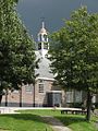
 Church of Schokland at Middelbuurt
 -
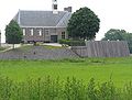 Church with sea wall
 -
 Church
 -
 Glacial erratic.The label on the left stone shows the Dutch for "Stones from Norway".
 -
 Church ruins at Ens
 -
 Schokland seen from the north
 -
![Schokland Museum [nl] houses](https://upload.wikimedia.org/wikipedia/commons/thumb/8/87/Schokland_Museum_Houses.jpg/120px-Schokland_Museum_Houses.jpg) Schokland Museumhouses
Schokland Museumhouses


![Schokland Museum [nl] houses](/translate/en.m.wikipedia.org?u=https%3A%2F%2Fen.m.wikipedia.org%2Fwiki%2FFile%3ASchokland_Museum_Houses.jpg&t=hv)
References
edit- ^(in Dutch)Feiten en cijfersArchived2014-04-19 at theWayback Machine,Municipality of Noordoostpolder
- ^"The island on dryland: The Dutch island of Schokland".www.radionetherlandsarchives.org.Feb 4, 2001.RetrievedFeb 19,2023.
External links
edit Media related toSchoklandat Wikimedia Commons
 Schoklandtravel guide from Wikivoyage
- Official website