This article has multiple issues.Please helpimprove itor discuss these issues on thetalk page.(Learn how and when to remove these messages)
|
Shikoku(Tứ quốc,Shikoku,pronounced[ɕikokɯ]ⓘ,lit. 'four provinces')is the smallest of thefour main islandsofJapan.It is 225 kilometres (140 miles) long and between 50 and 150 kilometres (30 and 95 miles) at its widest. It has a population of 3.8 million, the least populated of Japan's four main islands. It is south ofHonshuand northeast ofKyushu.[1]Shikoku's ancient names includeIyo-no-futana-shima(Y dư chi nhị danh đảo),Iyo-shima(Y dư đảo),andFutana-shima(Nhị danh đảo),and its current name refers to the four formerprovincesthat make up the island:Awa,Tosa,Sanuki,andIyo.[2]
Native name: Tứ quốc | |
|---|---|
 The island of Shikoku, Japan | |
 | |
| Geography | |
| Location | Japan |
| Archipelago | Japanese archipelago |
| Area | 18,801.73 km2(7,259.39 sq mi) |
| Area rank | 50th |
| Length | 225 km (139.8 mi) |
| Width | 50–150 km (31–93 mi) |
| Highest elevation | 1,982 m (6503 ft) |
| Highest point | Mount Ishizuchi |
| Administration | |
| Prefectures | |
| Largest settlement | (as of 1 May 2022)) |
| Demographics | |
| Population | 3,630,320 (1 May 2022) |
| Pop. density | 193/km2(500/sq mi) |
| Ethnic groups | Japanese |
| Additional information | |
| Time zone | |
Geography
edit
Shikoku Island, comprising Shikoku and its surrounding islands,[3]covers about 18,800 square kilometres (7,259 sq mi) and consists of fourprefectures:Ehime,Kagawa,Kōchi,andTokushima.Across theSeto Inland SealieWakayama,Osaka,Hyōgo,Okayama,Hiroshima,andYamaguchi PrefecturesonHonshu.To the west lieŌitaandMiyazaki PrefecturesonKyushu.

Shikoku is ranked as the50th largest island by areain the world. Additionally, it is ranked as the23rd most populated islandin the world, with a population density of 193 inhabitants per square kilometre (500/sq mi).
Mountains running east and west divide Shikoku into a narrow northern subregion, fronting on theSeto Inland Sea,and a southern part facing the Pacific Ocean. TheHydrangea hirtaspecies can be found in these mountain ranges. Most of the 3.8 million inhabitants live in the north, and all but one of the island's few larger cities are located there.Mount Ishizuchi(Thạch chùy sơn) in Ehime at 1,982 m (6,503 ft) is the highest mountain on the island. Industry is moderately well developed and includes the processing of ores from the importantBesshi copper mine.Land is used intensively. Wide alluvial areas, especially in the eastern part of the zone, are planted with rice and subsequently are double-cropped with winter wheat and barley. Fruit is grown throughout the northern area in great variety, including citrus fruits, persimmons, peaches, and grapes. Because of wheat production,Sanuki udon(Tán kỳ うどん) became an important part of the diet in Kagawa Prefecture (formerly Sanuki Province) in theEdo period.
The larger southern area of Shikoku is mountainous and sparsely populated. The only significant lowland is a small alluvial plain atKōchi,the prefectural capital. The area's mild winters stimulated sometruck farming,specializing in growing out-of-season vegetables under plastic covering. Two crops of rice can be cultivated annually in the southern area. Thepulp and paper industrytook advantage of the abundant forests and hydroelectric power.
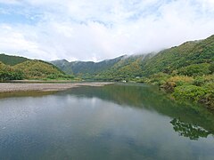
The major river in Shikoku is theYoshino River.It runs 196 km (121.8 mi) from its source close toMount Ishizuchi,flowing basically west to east across the northern boundaries of Kōchi and Tokushima Prefectures, reaching the sea at the city of Tokushima. The Yoshino is famous for Japan's best white-water rafting, with trips going along the Oboke Koboke sections of the river.
Shikoku has four important capes: Gamōda inAnan, Tokushimaon the easternmost point on the island, Sada inIkata, Ehimeon the westernmost point. Muroto inMuroto, Kōchiand Ashizuri, the southern extreme of Shikoku, inTosashimizu, Kōchi,jut into the Pacific Ocean. The island's northernmost point is inTakamatsu.
Unlike the other three major islands of Japan, Shikoku has no active volcanoes, and is the largest of Japan's islands to completely lack them.[4]But Shikoku did experience volcanic activity in the distant prehistoric past; a major volcaniccalderain the area of Mount Ishizuchi was active during theMiocenearound 14 million years ago[5]and the smallvolcanic coneofMount Iinoat an unknown date.[6]
-
 Mount Ishizuchiis the highest mountain in Shikoku.
 -
 Cape Ashizuri is at the southernmost tip of Shikoku.
 -
-
 Seto Inland Sea


Population
editShikoku has a total population of 3,630,320 in 2022. The largest city isMatsuyama(population: 507,137) and is the capital ofEhime Prefecture.Shikoku is the main island with the third largest population density, at 193 inhabitants per square kilometre (500/sq mi).
| List of 20 major cities in Shikoku | |||||||||
|---|---|---|---|---|---|---|---|---|---|
|
|
Rank | Cities | Prefecture | Population | Rank | Cities | Prefecture | Population |
|
1
|
507,137 | 11 | 67,891 | ||||||
2 |
414,363 | 12 | 60,106 | ||||||
3 |
321,910 | 13 | 56,258 | ||||||
4 |
250,150 | 14 | 53,368 | ||||||
5 |
147,334 | 15 | 49,487 | ||||||
6 |
113,755 | 16 | 45,763 | ||||||
7 |
108,744 | 17 | 46,176 | ||||||
8 |
102,830 | 18 | 39,352 | ||||||
9 |
80,952 | 19 | 37,707 | ||||||
10 |
68,213 | 20 | 35,288 | ||||||


Per Japanese census data,[7]and,[8]Shikoku region's peak population was at 1950 and has had negative population growth from 1950 to 1970 and 1990 onward.
| Year | Pop. | ±% |
|---|---|---|
| 1920 | 3,066,000 | — |
| 1930 | 3,310,000 | +8.0% |
| 1940 | 3,337,000 | +0.8% |
| 1950 | 4,221,000 | +26.5% |
| 1960 | 4,122,000 | −2.3% |
| 1970 | 3,904,000 | −5.3% |
| 1980 | 4,163,000 | +6.6% |
| 1990 | 4,195,000 | +0.8% |
| 2000 | 4,154,039 | −1.0% |
| 2010 | 3,977,282 | −4.3% |
| 2018 | 3,755,765 | −5.6% |
Culture
editSociety and architecture
editShikoku has historically been quite isolated and therefore it has kept the original characteristics of Japan for a longer period, especially in regards to vegetation and some architectural techniques. There are many Buddhist temples.
The "lost" Shikoku has been described by an American writer,Alex Kerr,who lived in a remote mountain village near Oboke ( đại bộ nguy ) for many years from 1970 onwards.
Ashizuri-Uwakai National Parkis located in the south-west part of Shikoku.
Traditions
edit
Shikoku is also famous for its88-temple pilgrimageof temples. The pilgrimage was established by the Heian-period Buddhist priestKūkai,a native of present-day Zentsūji-cho in Kagawa prefecture. According to legend, Kūkai still appears to pilgrims today. Most modern-day pilgrims travel by bus, rarely choosing the old-fashioned method of going by foot. They are seen wearing white jackets emblazoned with the characters readingdōgyō ninin(Đồng hành nhị nhân) meaning "two traveling together".
Tokushima Prefecture also has its annualAwa Odorirunning in August at the time of theObonfestival, which attracts thousands of tourists each year from all over Japan and from abroad.
Kōchi Prefecture is home to the first annualYosakoifestival. The largest festival in Kōchi, it takes place in August every year and attracts dancers and tourists from all over Japan.
Food
edit
One of the major foods of Shikoku isudon.[9]Udonis often served hot as a noodle soup in its simplest form, askake udon,in a mildly flavoured broth calledkakejiru,which is made ofdashi,soy sauce (shōyu), andmirin.It is usually topped with thinly chopped scallions. Other common toppings includetempura,often prawn orkakiage(a type of mixed tempurafritter), oraburaage,a type of deep-friedtofupockets seasoned with sugar, mirin, and soy sauce. A thin slice ofkamaboko,a halfmoon-shaped fish cake, is often added.Shichimican be added to taste. Another specialty isKōchi's signature dish, searedbonito.
The warm climate of Shikoku lends itself to the cultivation of citrus fruits. As a result,yuzu,mikanand other citrus fruits are plentiful on Shikoku and have become synonymous with the regions they are grown in.
Movements
editPioneeringnatural farmerMasanobu Fukuoka,author ofThe One-Straw Revolution,developed his methods here on his family's farm.
Sports
edit

Historically no Shikoku-basedsportsteam has competed in the top Japanese division ofbaseball,football (soccer)or evenrugby union.However, Tokushima Vortis have had two spells in the top flight of Japanese soccer (J1) in 2014 and 2021. Currently the major teams competing in Shikoku's major cities include:
- Naruto,Tokushima:
- Tokushima Vortis(football,J2)
- Tokushima Indigo Socks(baseball,SKIL)
- Matsuyama,Ehime
- Ehime FC(football, J2)
- Ehime Mandarin Pirates(baseball, SKIL)
- Imabari,Ehime:
- FC Imabari(football, J2)
- Takamatsu,Kagawa:
- Kamatamare Sanuki(football,J3)
- Kagawa Olive Guyners(baseball, SKIL)
- Kōchi,Kōchi:
- Kōchi United SC(football, J3)
- Kōchi Fighting Dogs(baseball, SKIL)
Notable sportspeople
editTwo time darts Women's World ChampionMikuru Suzukiis a native of Takamatsu in Kagawa Prefecture on Shikoku.[10]
Transportation
edit

Roads
editShikoku is connected to Honshu by threeexpressways,which together form theHonshū–Shikoku Bridge Project.
- Kobe-Awaji-Naruto Expressway(Eastern Shikoku)
- Nishiseto Expressway(Western Shikoku)
- Seto-Chūō Expressway(Central Shikoku)
The eastern gateway to Shikoku,NarutoinTokushima Prefecturehas been linked to theKobe-Awaji-Naruto Expresswaysince 1998. This line connects Shikoku to theKansaiarea which has a large population, including the largeconurbationsofOsaka,Kyoto,andKobe.Therefore, the Kobe-Awaji-Naruto Expressway carries a large traffic volume. Many highway buses are operated betweenKansaiandTokushima Prefecture.
The central part of Shikoku is connected to Honshu by ferry, air, and – since 1988 – by theGreat Seto Bridgenetwork. Until completion of the bridges, the region was isolated from the rest of Japan. The freer movement between Honshu and Shikoku was expected to promote economic development on both sides of the bridges, which has not materialized yet.
Within the island, a web ofnational highwaysconnects the major population centers. These includeRoutes 11,32,33,55,and56.
Rail
editTheShikoku Railway Company(JR Shikoku) serves the island and connects to Honshu via theGreat Seto Bridge.JR lines include:
- Dosan Line
- Honshi Bisan Line
- Kōtoku Line
- Mugi Line
- Naruto Line
- Seto Ōhashi Line
- Tokushima Line
- Uchiko Line
- Yodo Line
- Yosan Line
Private railway lines operate in each of the four prefectures on Shikoku.
Air travel
editShikoku lacks a full international airport but has four regional/domestic airports (Tokushima Airport,Takamatsu Airport,Kōchi Ryōma AirportandMatsuyama Airport). All of these airports have flights to Tokyo and other major Japanese cities such asOsaka,Nagoya,Sapporo,andFukuoka.International flights toSeoul,South Koreaare serviced byAsiana AirlinesfromMatsuyamaandTakamatsu.There are periodic international charter flights as well.
Sea Travel
Ferries link Shikoku to destinations including Honshu,Kyushu,and islands around Shikoku.
See also
editReferences
edit- ^Boquet, Yves (2017).The Philippine Archipelago.Springer. p. 16.ISBN9783319519265.
- ^"Shikoku and Awaji Island"(PDF).Japan National Tourism Organization. September 2011.Archived(PDF)from the original on 2013-02-04.Retrieved2013-05-02.
- ^"Geography | The Science of Our World".geography.com.Retrieved2024-04-29.
- ^"Shikoku: Frommer's Guide from".Answers.com.Archivedfrom the original on 2012-02-29.Retrieved2012-02-28.
- ^Takehara, Mami; Horie, Kenji; Tani, Kenichiro; Yoshida, Takeyoshi; Hokada, Tomokazu; Kiyokawa, Shoichi (2017). "Timescale of magma chamber processes revealed by U-Pb ages, trace element contents and morphology of zircons from the Ishizuchi caldera, Southwest Japan Arc".Island Arc.26(2): e12182.Bibcode:2017IsArc..26E2182T.doi:10.1111/iar.12182.S2CID133362063.
- ^"Mount Iino".Retrieved2023-04-23.
- ^Ehime 1995–2020 population statistics
- ^Shikoku 1920–2000 population statistics
- ^"tourism shikoku".tourism shikoku.Organization for Promotion of Tourism in Shikoku. Archived fromthe originalon 2014-12-05.Retrieved2014-11-27.
- ^"Japan's Miracle Takes Darts World by Storm".France24.com.France 24. 10 April 2019.Retrieved7 August2020.
 This article incorporates text from this source, which is in thepublic domain.Japan: A Country Study.Federal Research Division.