You can helpexpand this article with text translated fromthe corresponding articlein Japanese.(March 2016)Click [show] for important translation instructions.
|
Takatsu-ku(Cao tân khu)is one of the 7wardsof the city ofKawasakiinKanagawa Prefecture,Japan.As of 2010, the ward had an estimatedpopulationof 215,158 and adensityof 13,150 persons per km². The total area is 16.38 km².
Takatsu
Cao tân khu | |
|---|---|
| Takatsu Ward | |
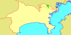
 Location of Takatsu inKanagawa | |
| Coordinates:35°35′58″N139°36′29″E/ 35.59944°N 139.60806°E | |
| Country | Japan |
| Region | Kantō |
| Prefecture | Kanagawa |
| City | Kawasaki |
| Established | April 1, 1972 |
| Area | |
• Total | 16.38 km2(6.32 sq mi) |
| Population (March 2010) | |
• Total | 215,158 |
| • Density | 13,150/km2(34,100/sq mi) |
| Time zone | UTC+9(Japan Standard Time) |
| - Tree | Ume |
| - Flower | Narcissus |
| Address | 2-8-1 Shimosakunobe, Takatsu-ku Kawasaki-shi, Kanagawa-ken 213-8570 |
| Website | Takatsu Ward Office |

Geography
editTakatsu Ward is located in eastern Kanagawa Prefecture, in the north-center portion of the city of Kawasaki, bordering on Tokyo. It is bordered to the north by theTama River.
Surrounding municipalities
editNeighborhoods
editMizonokuchi, Futago, Seta, Suwa, Kitamigata, Shimonoge, Hisamoto, Sakado, Kuji, Unane, Shimo-Sakunobe, Kami-Sakunobe, Mukaigaoka, Suenaga, Kajigaya, Shinsaku, Chitose, Chitose-Shin-cho, Shibokuchi, Shibokuchi-Fujimi-dai, Hisasue, Kanigaya, Akutsu, and Nogawa.
History
editArchaeologists have found stone tools from theJapanese Paleolithicperiod and ceramic shards from theJōmon periodat numerous locations in the area. Under theNara periodRitsuryōsystem, it became part of Tachibana DistrictMusashi Province.By theHeian periodit was part of ashōencoming under control theLater Hōjō clanfromOdawarain the lateMuromachi period.In theEdo period,it was administered astenryōterritory controlled directly by theTokugawa shogunate,but administered through varioushatamoto. After theMeiji Restoration,the area was divided into eight villages within Tachibana District in the newKanagawa Prefectureon April 1, 1889. These areas were annexed by the neighboring city of Kawasaki from 1937-1938. The area became part of a huge government sponsored housing project from the 1950s and 1960s. The area became part of Tama Ward with the division of the city of Kawasaki into wards from April 1972. In July 1982, Miyamae Ward was separated from Takatsu Ward.
Economy
editTakatsu Ward is largely a regional commercial center andbedroom communityfor central Kawasaki andTokyo.Industries are centered on food processing, electronics and precision equipment, and include:[citation needed]
- The corporate headquarters ofMitutoyo[1]andNKK Switches[2]
- Fujitsu General(Phú sĩ thông ゼネラル)
- Fujitsu Access(Phú sĩ thông アクセス)
- Bunkyodo(Văn giáo đường)
- Kanagawa Science Park(かながわサイエンスパーク)- a business incubation center. [ also Research center for L'oreal company.]
Transportation
editRailway
edit- JR East-Nambu Line
- Tokyu Corporation–Tōkyū Den-en-toshi Line/Tōkyū Ōimachi Line
- Futako-Shinchi-Takatsu-Mizonokuchi-Kajigaya(through service toTokyo Metro Hanzomon LineandTobu Isesaki Line)
Highway
edit- Japan National Route 246(Atsugi-Oyama Road, as "Atsugi-Kaido"(Hậu mộc nhai đạo)or "Oyama-Kaido"(Đại sơn nhai đạo))
- National Route 409(Fuchu Road, as "Fuchu-Kaido"(Phủ trung nhai đạo))
- National Route 466(No. 3 Keihin Road, as "Daisan-Keihin"(Đệ tam kinh bang))
Education
editThis sectionneeds expansion.You can help byadding to it.(October 2015) |
Municipal junior high schools:[3]
- Higashitakatsu (Đông cao tân trung học giáo)
- Higashitachibana (Đông quất trung học giáo)
- Nishitakatsu (Tây cao tân trung học giáo)
- Tachibana (Quất trung học giáo)
- Takatsu (Cao tân trung học giáo)
Municipal elementary schools:[4]
- Higashi Takatsu (Đông cao tân tiểu học giáo)
- Hisamoto (Cửu bổn tiểu học giáo)
- Hisasue (Cửu mạt tiểu học giáo)
- Kajigaya (Vĩ ヶ cốc tiểu học giáo)
- Kamisakunobe (Thượng tác diên tiểu học giáo)
- Kuji (Cửu địa tiểu học giáo)
- Minamihara (Nam nguyên tiểu học giáo)
- Nishi Kajigaya (Tây vĩ ヶ cốc tiểu học giáo)
- Sakado (Bản hộ tiểu học giáo)
- Shibokuchi (Tử mẫu khẩu tiểu học giáo)
- Shimosakunobe (Hạ tác diên tiểu học giáo)
- Shinsaku (Tân tác tiểu học giáo)
- Suenaga (Mạt trường tiểu học giáo)
- Tachibana (Quất tiểu học giáo)
- Takatsu (Cao tân tiểu học giáo)
There is aNorth Korean school,Nambu Korean Primary School ( nam võ triều tiên sơ cấp học giáo ).[5]
Shrines and temples
editNoted people from Takatsu Ward
edit- Tarō Okamoto,artist
- Yoshinobu Minowa,professional soccer player
- Masahiro Abe,professional baseball player
- Riko Narumi,actress
- Eugene Tzigane,conductor
References
edit- ^"Company Profile."Mitutoyo.Retrieved on May 13, 2013. "20-1, Sakado 1-Chome, Takatsu-ku, Kawasaki-shi, Kanagawa 213-8533, Japan"
- ^"Company Profile."NKK Switches.Retrieved on January 4, 2019
- ^"Cao tân khu の trung học giáo nhất lãm".Kawasaki Combined Education Center.Retrieved2022-12-27.
- ^"Cao tân khu の tiểu học giáo nhất lãm".Kawasaki Combined Education Center.Retrieved2022-12-27.
- ^"The Education System and Schools"(Archive). Government of Kanagawa Prefecture. Retrieved on October 13, 2015.
External links
edit- Takatsu Ward Office(in Japanese)(Archive)

