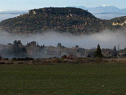
Tavertet(Catalan pronunciation:[təβəɾˈtɛt]) is a small town located above some cliffs, 900m above sea level, in the area known asCollsacabra,north of theGuilleries,in thecomarcaofOsonainCatalonia.
Tavertet | |
|---|---|
 Tavertet with thePuig de les Baumesrising over the town and thePre-Pyreneesin the far distance | |
| Coordinates:41°59′51″N2°25′11″E/ 41.99750°N 2.41972°E | |
| Country | |
| Community | |
| Province | Barcelona |
| Comarca | Osona |
| Government | |
| •Mayor | Lurdes Rovira Plarromaní (2015)[1] |
| Area | |
• Total | 32.5 km2(12.5 sq mi) |
| Elevation | 869 m (2,851 ft) |
| Population (2018)[3] | |
• Total | 111 |
| • Density | 3.4/km2(8.8/sq mi) |
| Website | tavertet |
Below the cliffs isPantà de Sau,a reservoir that dammed the waters of the river Ter in the 1960s. Tavertet is nowadays a tourist-oriented town with many holiday homes, whereRaimon Panikkarlived. Tavertet is linked by road BV5207 to the town ofL'Esquirol,also known as Santa Maria de Corcó. There is also a minor road north of the village above the cliffs through a beech forest linking the town toRupit.

References
edit- ^"Ajuntament de Tavertet".Generalitat of Catalonia.Retrieved2015-11-13.
- ^"El municipi en xifres: Tavertet".Statistical Institute of Catalonia.Retrieved2015-11-23.
- ^Municipal Register of Spain 2018.National Statistics Institute.
External links
edit- Government data pages(in Catalan)
- Link with the web page:Associació Amics de Tavertet(in Catalan)

