Thessaly(/ˈθɛsəli/THESS-ə-lee;Greek:Θεσσαλία,romanized:Thessalía[θesaˈli.a];ancientThessalian:Πετθαλία,Petthalía) is a traditionalgeographicand modernadministrative regionofGreece,comprising most of theancient regionof the same name. Before theGreek Dark Ages,Thessaly was known asAeolia(Ancient Greek:Αἰολία,Aiolía), and appears thus inHomer'sOdyssey.
Thessaly
Θεσσαλία(Greek) | |
|---|---|
 Flag | |
 Thessaly within Greece | |
| Coordinates:39°36′N22°12′E/ 39.6°N 22.2°E | |
| Country | |
| Decentralized Administration | Thessaly and Central Greece |
| Cession | 1881 |
| Capital | Larissa |
| Port city | Volos |
| Regional units | |
| Government | |
| • Regional governor | Dimitris Kouretas(PASOK – Movement for Change) |
| Area | |
| • Total | 14,036.64 km2(5,419.58 sq mi) |
| Population (2021)[1] | |
| • Total | 687,527 |
| • Density | 49/km2(130/sq mi) |
| Demonym | Thessalian |
| GDP | |
| • Total | €9.337 billion (2021) |
| Time zone | UTC+2(EET) |
| • Summer (DST) | UTC+3(EEST) |
| ISO 3166 code | GR-E |
| HDI(2019) | 0.868[3] very high·7th of 13 |
| Website | www |
Thessalybecame partof themodern Greek statein 1881, after four and a half centuries ofOttoman rule.Since 1987 it has formed one of the country's 13regions[4]and is further (since theKallikratis reformof 2011) sub-divided into fiveregional unitsand 25municipalities.The capital of the region isLarissa.Thessaly lies in northern central Greece and borders the regions ofMacedoniato the north,Epirusto the west,Central Greeceto the south, and theAegean Seato the east. The Thessaly region also includes theSporadesislands.
Name and etymology
editThessaly is named after theThessaloi,anancient Greek tribe.The meaning of the name of this tribe is unknown, and many theories have been made about its etymology. According to the Dutch linguistRobert S. P. Beekes,the name predates Greek presence in the region and could come from thePre-Greekform reconstructed as *Kʷʰeťťal-.[5]The Greek linguistGeorgios Babiniotisalso assigns the origin of the name of the Thessalians to pre-Greek times, although he does not try to explain its etymology.[6]InAromanianit is referred to asTesalia.[7]
Mythology
editInHomer's epic, theOdyssey,the heroOdysseusvisited Aeolia, the kingdom ofAeolus,which was the old name for Thessaly.[8]
The Plain of Thessaly, which lies betweenMount Oeta/Othrys andMount Olympus,was the site of thebattlebetween theTitansand theOlympians.[9]
According to legend,Jasonand theArgonautslaunched their search for theGolden Fleecefrom the Magnesia Peninsula.
History
edit

Ancient history
editThessaly was home to extensiveNeolithicandChalcolithiccultures around 6000–2500 BC (seeCardium pottery,DiminiandSesklo).Mycenaeansettlements have also been discovered, for example at the sites ofIolcos,DiminiandSesklo(nearVolos). In Archaic andClassicaltimes, the lowlands of Thessaly became the home of baronial families, such as theAleuadaeofLarissaor the Scopads of Crannon.
In the summer of 480 BC, thePersiansinvaded Thessaly.The Greek army that guarded theVale of Tempewas alerted byAlexander I of Macedonand evacuated the road before the enemy arrived. Not much later, Thessaly surrendered to the Persians.[10]The Thessalian family ofAleuadaejoined the Persians subsequently. The following year, the Persians were decisively defeated at theBattle of Plataeaand withdrew from all of their European possessions, including Thessaly.[11]
In the 4th century BC, after theGreco-Persian Warshad long ended,Jason of Pheraetransformed the region into a significant military power, recalling the glory of Early Archaic times. Shortly after,Philip II of Macedonwas appointedArchonof Thessaly, and Thessaly was thereafter associated with the Macedonian Kingdom for the next centuries.
Thessaly later became part of theRoman Empireas part of the province ofMacedonia;when that was broken up, the name resurfaced in two of its late Roman successor provinces:Thessalia PrimaandThessalia Secunda.
Byzantine period
edit

Thessaly remained part of the East Roman "Byzantine" Empire after the collapse of Roman power in the west, and subsequently suffered many invasions, such as by the Slavic tribe of theBelegezitesin the 7th century AD.[12]TheAvarshad arrived in Europe in the late 550s.[13]: 29 They asserted their authority over many Slavs, who were divided into numerous petty tribes.[14]Many Slavs were galvanized into an effective infantry force, by the Avars. In the 7th century the Avar-Slav alliance began to raid the Byzantine Empire,laying siegeto Thessalonica and even the imperial capitalConstantinopleitself.
By the 8th century,Slavshad occupied most of the Balkans from Austria to the Peloponnese, and from the Adriatic to the Black seas, with the exception of the coastal areas and certain mountainous regions of the Greek peninsula.[15]Relations between the Slavs and Greeks were probably peaceful apart from the (supposed) initial settlement and intermittent uprisings.[16]Being agriculturalists, the Slavs probably traded with the Greeks inside towns.[17]It is likely that the re-Hellenizationhad already begun by way of this contact. This process would be completed by a newly reinvigorated Byzantine Empire.
With the abatement ofArab-Byzantine Wars,the Byzantine Empire began to consolidate its power in those areas of mainland Greece occupied by Proto-Slavic tribes. Following the campaigns of the Byzantine generalStaurakiosin 782–783, the Byzantine Empire recovered Thessaly, taking many Slavs as prisoners.[18]Apart from military expeditions against Slavs, the re-Hellenization process begun under Nicephorus I involved (often forcible) transfer of peoples.[19]
Many Slavs were moved to other parts of the empire such as Anatolia and made to serve in the military.[20]In return, many Greeks from Sicily and Asia Minor were brought to the interior of Greece, to increase the number of defenders at the Emperor's disposal and dilute the concentration of Slavs.[21]
Late Medieval period
edit
In 977 Byzantine Thessaly was raided by theBulgarian Empire.In 1066 dissatisfaction with the taxation policy led the Aromanian and Bulgarian population of Thessaly to revolt against the Byzantine Empire under the leadership of a local lord,Nikoulitzas Delphinas.The revolt, which began inLarissa,soon expanded toTrikalaand later northwards to the Byzantine-Bulgarian border.[22]In 1199–1201 another unsuccessful revolt was led byManuel Kamytzes,son-in-law of Byzantine emperorAlexios III Angelos,with the support ofDobromir Chrysos,the autonomous ruler ofProsek.Kamytzes managed to establish a short-lived principality in northern Thessaly, before he was overcome by an imperial expedition.[23]

Following thesiege of Constantinopleand the dissolution of theByzantine Empireby theFourth Crusadein April 1204, Thessaly passed toBoniface of Montferrat'sKingdom of Thessalonicain the wider context of theFrankokratia.With his Greek ties, Boniface won the support of the Greek population and of various important Greek families.[24][25]In 1212,Michael I Komnenos Doukas,ruler ofEpirus,led his troops into Thessaly. Larissa and much of central Thessaly came under Epirote rule, thereby separating Thessalonica from the Crusader principalities in southern Greece.[26]Michael's work was completed by his half-brother and successor,Theodore Komnenos Doukas,who by 1220 completed the recovery of the entire region, and assignedpronoiaito aristocratic Greek families.[27]

TheVlachs(Aromanians) of Thessaly (originally a chieflytranshumantRomance-speakingpopulation)[28][29]first appear in Byzantine sources in the 11th century, in theStrategikon of KekaumenosandAnna Komnene'sAlexiad).[28][29]In the 12th century, the Jewish travellerBenjamin of Tudelarecords the existence of the district of "Vlachia" nearHalmyrosin eastern Thessaly, while the Byzantine historianNiketas Choniatesplaces "Great Vlachia"(Aromanian:Vlãhia Mari) nearMeteora.The term is also used by the 13th-century scholarGeorge Pachymeres,and it appears as a distinct administrative unit in 1276, when thepinkernesRaoul Komnenoswas its governor (kephale).[28]
From 1271 to 1318 Thessaly was an independent despotate that extended toAcarnaniaandAetolia,run by the dynasty founded byJohn I Doukas.John ruled from 1271 until his death in 1289 and was succeeded by his sons Constantine and Theodore. At this time, Thessaly came under Byzantine suzerainty, though it largely retained its independence.[30]After Constatine's death in 1303, it was ruled byJohn II Doukasuntil his death in 1318. From 1306 to 1310, theAlmogavarsorCatalan Companyof the East (Societas Catalanorum Magna), plundered Thessaly.[31]In 1310, they occupied a series of forts in the south.[31]From there they departed to theDuchy of Athens,called by the dukeWalter I,whom they eventually killed in battle and took over theDuchy of Athens.[32]In 1318, with the death of John II, Thessalian independence came to an end, and the Almogavars occupied Siderokastron and southern Thessaly (1319) and formed theDuchy of Neopatria.The other parts of Thessaly either came under Byzantine rule or were ruled by their own nobility.[33]These local magnates eventually started fighting amongst themselves. Those in the south, such as the Melissenos family of Volos, sought the help of the Catalans, while those in the north, such as the Gavrilopoulos family of Trikala, turned towards Byzantium.[33]At this time, some of Thessaly's ports came under Venetian rule.[34]In 1332, most of Thessaly was taken by the Byzantines following a campaign byAndronikos III Paleologos.[35]He left its administration toMichael Monomachos,who governed it for the next 10 years.[35]
Groups of Albanians moved into Thessaly as early as 1268 as mercenaries ofMichael Doukas.[36]TheAlbaniantribes ofBua,Malakasioiand Mazaraki were described as "unruly" nomads living in the mountains of Thessaly in the early 14th century inEmperor John VI Kantakouzenos’‘History’. They numbered approximately 12,000. Kantakouzenos describes a pact they made to serve the Byzantine Emperor and pay tribute to him ca. 1332 in exchange for using the lowland areas of Thessaly in the summer months.[37]Albanian groups were given military holdingsFanariin the 1330s and by the end of the 14th century and the Ottoman takeover of the region, they were an integral part of the military structures of Thessaly. Two of their military leaders known in Byzantine sources as Peter and John Sebastopoulos controlled the small towns ofPharsalaandDomokos.[38]
In 1348, Thessaly was invaded and occupied by theSerbian EmpireofStefan Dušan,under the generalPreljub.After the latter's death in 1356, the region was conquered byNikephoros Orsiniafter he won the support of the local Greek population.[39]After his death three years later, it was taken over by the self-proclaimed Serbian emperorSimeon Uroš.Simeon's sonJohn Urošsucceeded in 1370 but abdicated in 1373, and Thessaly was administered by the Greek Angeloi-Philanthropenoi clan until theOttomanconquest c. 1393.
Ottoman period
editOttoman control began in the late 14th century with the capture of Larissa in 1392-93 and consolidated in the early 15th century. Nevertheless, Ottoman control was threatened throughout this era by groups of Greeks, Albanians and Aromanians who based themselves in the mountainous areas of Thessaly.[40]At the time of the Ottoman conquest, the great Eastern plain of Thessaly was almost entirely depopulated as a result of the nearly continuous warfare of the previous decades. It was resettled by Turkish settlers from WesternAnatoliaandGreeksfrom Western Thessaly and the surrounding mountains. In the following decades, the population of this area grew very rapidly as a result of law and order.[41]Thessaly was ruled through theSanjak of Tirhalaadministrative division during theOttoman period.In the 1520s,Muslimsmade up of 17.5% of the population of the Sanjak.[42]
Failed Greek uprisings occurred in1600/1and 1612, and during theMorean War(1684–1699) and theOrlov Revolt(1770).[43]
In 1780,Ali Pasha of Ioanninatook over control of Thessaly, and consolidated his rule after 1808, when he suppressed a local uprising. Heavy taxation, however, ruined the province's commerce, and coupled with the outbreak of the plague in 1813, reduced the population to some 200,000 by 1820.[43]Rigas Feraios,the important Greek intellectual and forerunner of theGreek War of Independencewas from the region. He was born inVelestino,[44]near the ancient town ofPherae.
When theGreek War of Independencebroke out in 1821, Greek risings occurred in thePelionandOlympusmountains as well as the western mountains around Fanari, but they were swiftly suppressed by the Ottoman armies underMehmed Reshid PashaandMahmud Dramali Pasha.[43]After the establishment of the independentKingdom of Greece,Greek nationalist agitation continued, with further revolts in 1841, in 1854 during theCrimean War,and again during theRusso-Turkish War of 1877–1878.In 1880 Thessaly's population consisted of approximately 285,000 Greeks, 40,000 Turks, and 40,000 Jews.[43]
Modern
edit
Thessaly became part of the modern Greek state in 1881, after theConvention of Constantinopleexcept the area around the town ofElassona,which remained in Ottoman hands until 1912. It was briefly captured by Ottomans during theGreco-Turkish War of 1897.After theTreaty of Constantinople (1897),Greece was forced to cede minor border areas and to pay heavy reparations. The remaining part of Thessaly held by the Ottomans was finally regained by the Greeks during theFirst Balkan Warin 1912.[43]In 1923, the entire Muslim population was sent to Turkey following thepopulation exchange between Greece and Turkeyat the end of theGreco-Turkish War.
DuringWorld War II,Thessaly was occupied by theKingdom of Italyfrom April 1941 to September of 1943. After theArmistice of Cassibile,Germanyoccupied Thessaly until October 1944. It became a major centre of theGreek Resistance,most famously seeing the desertion of the ItalianPinerolo Divisionto the guerrillas ofEAM-ELASin 1943.
Geography
edit


Thessaly occupies the east side of thePinduswatershed, extending south from Macedonia to theAegean Sea.The northern tier of Thessaly is defined by a generally southwest-northeast spur of the Pindus range that includesMount Olympus,close to the Macedonian border. Within that broken spur of mountains are several basins and river valleys.
The easternmost extremity of the spur extends southeastward from Mount Olympus along the Aegean coast, terminating in theMagnesiaPeninsula that envelops thePagasetic Gulf(also called the Gulf of Volos), and forms an inlet of the Aegean Sea. Thessaly's major river, thePineios,flows eastward from the central Pindus Range just south of the spur, emptying into theThermaic Gulf.
TheTrikalaandLarissalowlands form acentral plainwhich is surrounded by a ring of mountains. It has distinct summer and winter seasons, with summer rains augmenting the fertility of the plains. This has led to Thessaly occasionally being called the "breadbasket of Greece".
The region is well delineated by topographical boundaries. TheChasiaandKamvouniamountains lie to the north, the Mount Olympus massif to the northeast. To the west lies the Pindus mountain range, to the southeast the coastal mountains ofÓssaandPelion.
Several tributaries of the Pineios flow through the region.
Climate
editMost of the province has ahot summer Mediterranean climate(Köppen:Csa), but also found is acold semi-arid climate(BSk) including the capitalLarissa(on itsMediterraneanedge of category). Even in the north of Thessaly a rarehumid subtropical climate(Cfa) can be found, although it is different from a climate typically below or above the tropics, it also marks the limit of this rareCfsubtype on theEuropean continent(e. g. the small village of Kalvia).[45]
Demographics
editThe population of the region of Thessaly was 687,527 in 2021 census. The region has shrunk by 45,235 people between 2011 and 2021, experiencing a population loss of 6.2%.[1]
In 2011, the population of the region of Thessaly was 732,762 and represented 6.8% of the total population of Greece. A 2.8% decrease in the population since 2001 was noted, but Thessaly remains Greece's third most populous region.[46]
The population break-down is 44% urban, 40% agrarian, and 16% semi-urban. A decrease in the agrarian population has been accompanied by an increase in the semi-urban population.
The metropolitan area of Larissa, the capital of Thessaly, is home to more than 230,000 people, making it the biggest city of the region.
An Aromanian minority resides in Thessaly. This region, along withEpirusandMacedonia,are the regions with the biggest concentrations ofGreek Aromanians.[47]Another notable population group of Thessaly are theKaragounides,an ethnic Greek subgroup.
Language
editTheAeolicdialect of Greek was spoken in Thessaly. This included several local varieties, in particular the variants ofPelasgiotisand Thessaliotis. The language was not written.[48]
Apart from Greek, Aromanian is also spoken in Thessaly. SomeAromanian dialectsfrom the region have some unique peculiarities of their own, such as that ofKrania,which is one of the few withdifferential object marking(DOM) along with those dialects spoken at the west ofOhridinNorth Macedonia.[49]
Major settlements
editEconomy
editThe alluvial soils of thePineiosBasin and its tributaries make Thessaly a vital agricultural area, particularly for the production ofgrain,cattle,andsheep.Modernization of agricultural practices in the mid-20th century has controlled the chronic flooding that had restricted agricultural expansion and diversification in the low-lying plains. Thessaly is the leading cattle-raising area ofGreece,and Aromanian shepherds move large flocks ofsheepandgoatsseasonally between higher and lower elevations.
In the last few decades, there has been a rise in the cultivation of dried nuts such asalmonds,pistachios,andwalnuts,especially in the region ofAlmyros.An increase in the number of olive oil trees has been also observed. The nearly landlockedGulf of Pagasaiprovides a natural harbor atVolosfor shipping agricultural products from the plains and chromium from the mountains.
TheGross domestic product(GDP) of the province was 9.7 billion € in 2018, accounting for 5.2% of Greek economic output. GDP per capita adjusted for purchasing power was 16,100 € or 53% of the EU27 average in the same year. The GDP per employee was 65% of the EU average.[50]
The unemployment rate stood at 20.6% in 2017.[51]
| Year | 2006 | 2007 | 2008 | 2009 | 2010 | 2011 | 2012 | 2013 | 2014 | 2015 | 2016 | 2017 |
|---|---|---|---|---|---|---|---|---|---|---|---|---|
| unemployment rate (in %) |
8.2 | 7.8 | 8.3 | 9.2 | 12.1 | 16.8 | 22.6 | 25.4 | 25.4 | 26.9 | 25.5 | 20.6 |
Transport
editThere are a number of highways such asE75,and the main railway fromAthenstoThessaloniki(Salonika) crosses Thessaly. The region is directly linked to the rest of Europe through theInternational Airport of Central Greece,which is located inNea Anchialos,a small distance fromVolosandLarisa.Charter flights link the region and bring tourists to the wider area, mainly inPelionandMeteora.The new infrastructure includes a brand new terminal ready to serve 1500 passengers per hour and new airplanes.
Administration
editAlthough the historical region of Thessaly extended south intoPhthiotisand at times north intoWest Macedonia,today the term 'Thessaly' is identified with the modern Administrative Region which was established in the 1987 administrative reform. With the 2010Kallikratis plan,the powers and authority of the region were redefined and extended.
Along withCentral Greece,it is supervised by theDecentralized Administration of Thessaly and Central Greece,based atLarissa.The region of Thessaly is divided into fiveregional units(four were pre-Kallikratisprefectures),Karditsa,Larissa,Magnesia,theSporadesandTrikala,which are further subdivided into twenty-fivemunicipalities.
| Regional Unit | Municipality | Population (2011) |
|---|---|---|
| Larissa | Agia | 11,470 |
| Larissa | Elassona | 32,121 |
| Larissa | Farsala | 18,545 |
| Larissa | Kileler | 20,854 |
| Larissa | Larissa | 162,591 |
| Larissa | Tempi | 13,712 |
| Larissa | Tyrnavos | 25,032 |
| Sporades | Skiathos | 6,610 |
| Sporades | Skopelos | 4,960 |
| Sporades | Alonnisos | 2,750 |
| Magnesia | Almyros | 18,614 |
| Magnesia | Rigas Feraios | 10,922 |
| Magnesia | South Pelion | 10,216 |
| Magnesia | Volos | 144,449 |
| Magnesia | Zagora-Mouresi | 5,809 |
| Karditsa | Argithea | 3,450 |
| Karditsa | Karditsa | 56,747 |
| Karditsa | Lake Plastiras | 4,635 |
| Karditsa | Mouzaki | 13,122 |
| Karditsa | Palamas | 16,726 |
| Karditsa | Sofades | 18,864 |
| Trikala | Farkadona | 13,396 |
| Trikala | Kalampaka | 21,991 |
| Trikala | Pyli | 14,343 |
| Trikala | Trikala | 81,355 |
The regional governor isDimitris Kouretas,who was elected in the second round of the2023 regional electionand took office on 1 January 2024.
Ancient coinage
edit-
 Silver hemidrachm ofPharsalosstruck 450-400 BC
 -
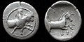 Silver hemidrachm ofTrikkastruck 440-400 BC
 -
 Silver hemidrachm ofThessalian Leaguestruck 470-460 BC
 -
 Bronze coin of Ekkarra struck 325-320 BC
 -
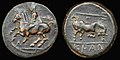 Bronze coin ofKrannonstruck 400-344 BC
 -
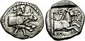 Hemidrachm coin ofPelinnastruck 460-420 BC


See also
edit- Vale of Tempe
- List of traditional Greek place names
- CERETETH,Center of Technology Thessaly
References
edit- ^ab"Census 2021 GR"(PDF)(Press release).Hellenic Statistical Authority.2022-07-19.Retrieved2022-09-12.
- ^"Population on 1 January by age, sex and NUTS 2 region",www.ec.europa.eu
- ^"Sub-national HDI - Area Database - Global Data Lab".hdi.globaldatalab.org.Retrieved2021-07-20.
- ^Π.Δ. (March 6, 1987).Καθορισμός των Περιφερειών της Χώρας για το σχεδιασμό κ.λ.π. της Περιφερειακής Ανάπτυξης[Determination of the Regions of the Country for the planning etc. of the development of the regions].ΦΕΚ.pp. 51/87.
- ^Beekes, Robert(2009).Etymological Dictionary of Greek.Brill Publishers.p. 544.ISBN978-90-04-17418-4.
- ^Babiniotis, Georgios(2009).Ετυμολογικό Λεξικό της Νέας Ελληνικής Γλώσσας(in Greek). Lexicology Centre.
- ^Fârshârotunr. 30.p. 14.
- ^For more, see:Homer,Odyssey,10.1
- ^Hesiod,Theogony630-631.
- ^Rhodes, P.J. (September 30, 2014).A Short History of Ancient Greece.I.B. Tauris.p. 59.ISBN9781780765945.RetrievedDecember 24,2014.
- ^Joseph Roisman; Ian Worthington, eds. (6 December 2010).A Companion to Ancient Macedonia.John Wiley & Sons. p. 139.ISBN978-1-4051-7936-2.OCLC1025542935.
- ^de Laet, Sigfried J.; Herrmann, Joachim (January 1, 1996)."The Invasion of Slaves and Avars (c. 568 to 626)".In Tapkova-Zaimova, Vasilka (ed.).History of Humanity: From the seventh century B.C. to the seventh century A.D.UNESCO.p. 252.ISBN978-92-3-102812-0.
- ^Fine, John V. A., Jr. 1983,Early Medieval Balkans: A Critical Survey From the Sixth to the Late Twelfth Century,University of Michigan PressISBN9780472100255
- ^Fine 1991,p. 30.
- ^Fine 1991,p. 36.
- ^Fine 1991,p. 63.
- ^Fine 1991,p. 61.
- ^Fine 1991,p. 79.
- ^Fine 1991,p. 81.
- ^Fine 1991,p. 66.
- ^Fine 1991,p. 82.
- ^Fine 1991,p. 216.
- ^Fine 1994,p. 32.
- ^Fine 1994,pp. 63.
- ^Fine 1994,pp. 64.
- ^Fine 1994,p. 68.
- ^Fine 1994,p. 114.
- ^abcKazhdan 1991,p. 2183.
- ^abKazhdan 1991,p. 2184.
- ^Fine 1994,p. 235.
- ^abFine 1994,p. 241.
- ^Fine 1994,p. 242.
- ^abFine 1994,p. 243.
- ^Fine 1994,p. 247.
- ^abFine 1994,p. 253.
- ^Lopasic, Alexander (1992)."Cultural Values of the Albanians in the Diaspora".In Winnifrith, Tom (ed.).Perspectives On Albania.Springer. p. 90.ISBN978-1-349-22050-2.
- ^Elsie, Robert."Texts and Documents of Albanian History".albanianhistory.net.Retrieved2021-10-09.
- ^Magdalino, Paul (2012)."Between Romaniae: Thessaly and Epirus in the Later Middle Ages".In Arbel, Benjamin; Hamilton, Bernard; Jacoby, David (eds.).Latins and Greeks in the Eastern Mediterranean After 1204.Routledge. p. 103.ISBN978-1136289163.
- ^Fine 1994,p. 347.
- ^Savvides, Alexis (1998)."Splintered Medieval Hellenism: The Semi-Autonomous State of Thessaly (A.d. 1213/1222 to 1454/1470) and ITS Place in History".Byzantion.68(2): 416.JSTOR44172339.
Following the Ottoman capture of Larissa in 1392/1393, the Turkish forces moved southward towards Hellas and invaded the Peloponnese, which had already experienced their initial devastations; the next decades would witness the building-up of local resistance in Thessaly on the part of sections of Greeks, Albanians and Vlachs, who had taken to the mountains
- ^Kiel, Machiel (2016-10-03),"The Ottoman Imperial Registers",Reconstructing Past Population Trends in Mediterranean Europe (3000 BC - AD 1800),Oxbow Books, pp. 196–198,doi:10.2307/j.ctvh1dqhd.21,retrieved2023-03-21
- ^Minkov, Anton (2004).Conversion to Islam in the Balkans: Kisve bahası petitions and Ottoman social life, 1670-1730.Leiden. p. 49.ISBN1-4237-1251-X.OCLC191947039.
{{cite book}}:CS1 maint: location missing publisher (link) - ^abcdeSavvides 2000,pp. 420–422.
- ^Daskalov, Roumen Dontchev; Marinov, Tchavdar (June 13, 2013).Entangled Histories of the Balkans: National Ideologies and Language Policies.Vol. 1.Brill Publishers.p. 159.ISBN978-9004250765.
- ^"Updated Köppen-Geiger climate map of the world".people.eng.unimelb.edu.au.Retrieved2019-01-18.
- ^"Demographic and social characteristics of the Resident Population of Greece according to the 2011 Population"(PDF).Housing Census.Hellenic Statistical Authority.September 12, 2014. Archived fromthe original(PDF)on September 8, 2015.RetrievedMarch 20,2014.
- ^Kahl, Thede (2003)."Aromanians in Greece: Minority or Vlach-speaking Greeks?"(PDF).Jahrbücher für Geschichte und Kultur Südosteuropas.5:205–219.
- ^Frits Waanders, “Thessalian”, in: Encyclopedia of Ancient Greek Language and Linguistics, Managing Editors Online Edition: First Last. Consulted online on 31 August 2020 <http://dx.doi.org/10.1163/2214-448X_eagll_COM_00000349>
- ^Bužarovska, Eleni (2020)."The contact hypothesis revised: DOM in the South Slavic periphery".Journal of Language Contact.13(1): 57–95.doi:10.1163/19552629-bja10003.S2CID225734803.
- ^"Regional GDP per capita ranged from 30% to 263% of the EU average in 2018".Eurostat.
- ^"Regional Unemployment by NUTS2 Region".Eurostat.
Sources
edit- Fine, John V. A. Jr.(1991) [1983].The Early Medieval Balkans: A Critical Survey from the Sixth to the Late Twelfth Century.Ann Arbor: University of Michigan Press.ISBN0-472-08149-7.
- Fine, John V. A. Jr.(1994) [1987].The Late Medieval Balkans: A Critical Survey from the Late Twelfth Century to the Ottoman Conquest.Ann Arbor, Michigan: University of Michigan Press.ISBN0-472-08260-4.
- Kazhdan, Alexander(1991). "Vlachia". InKazhdan, Alexander(ed.).The Oxford Dictionary of Byzantium.Oxford and New York: Oxford University Press.ISBN0-19-504652-8.
- Smith, William,ed. (1857)."Thessalia".Dictionary of Greek and Roman Geography.Vol. 2. Walton and Mayberly. pp. 1165–1170.Retrieved12 October2018.
- Savvides, Alexis G. C. (2000)."Tesalya".InBearman, P. J.;Bianquis, Th.;Bosworth, C. E.;van Donzel, E.&Heinrichs, W. P.(eds.).The Encyclopaedia of Islam, Second Edition.Volume X: T–U.Leiden: E. J. Brill. pp. 420–422.ISBN978-90-04-11211-7.
External links
edit- Official website
 (in Greek)
 - Bagnall, R., J. Drinkwater, A. Esmonde-Cleary, W. Harris, R. Knapp, S. Mitchell, S. Parker, C. Wells, J. Wilkes, R. Talbert, M. E. Downs, M. Joann McDaniel, B. Z. Lund, T. Elliott, S. Gillies (15 February 2012)."Places: 991374 (Thessalia)".Pleiades.RetrievedMarch 8,2012.
{{cite web}}:CS1 maint: multiple names: authors list (link)