TheTaurus Mountains(Turkish:Toros DağlarıorToroslar,Greek:Ταύρος) are amountain complexin southernTurkey,separating theMediterraneancoastal region from the centralAnatolian Plateau.The system extends along a curve fromLake Eğirdirin the west to the upper reaches of theEuphratesandTigrisrivers in the east. It is a part of theAlpide beltinEurasia.
| Taurus Mountains | |
|---|---|
 Demirkazık inNiğde Province | |
| Highest point | |
| Peak | Mt. Demirkazık(3,756 m) |
| Naming | |
| Native name | Toros Dağları(Turkish) |
| Geography | |
 | |
| Country | Turkey |
| Range coordinates | 37°N33°E/ 37°N 33°E |
Etymology
editThe mountain range under the current name was mentioned inThe HistoriesbyPolybiusas Ταῦρος (Taûros).Heinrich Kiepertwrites inLehrbuch der alten Geographiethat the name was borrowed intoAncient Greekfrom theSemitic(Old Aramaic) rootטורא(ṭūrā), meaning "mountain".[1][2]
Geography
editThe Taurus Mountains are divided into three chains from west to east as follows;
- Western Taurus(Batı Toroslar)
- Central Taurus(Orta Toroslar)
- Southeastern Taurus(Güneydoğu Toroslar)
Western Taurus
edit
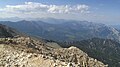
The Western Taurus Mountains form an arc around theGulf of Antalya.It includes the Akdağlar, Bey Mountains, Katrancık Mountain, Kuyucak Mountains, and Geyik Mountains. The EastTaşeli PlateauandGoksu Riverdivide it from the Central Taurus Mountains. It has many peaks rising above 3,000–3,700 m (9,800–12,100 ft).Mt. Kizlarsivrisi,3,086 m (10,125 ft), in the Bey Mountains is the highest peak in the Western Taurus.[3]
-
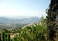
 Termessosis an ancient city in the western Taurus
 -
 Antalyawith the sunset and mountains in the west
 -
 Alanya,and the surrounding mountains


Central Taurus
editThe Central Taurus Mountains are roughly defined to include northernMersin Provinceand northwesternAdana Province.The highest point in the Central Taurus isMt. Demirkazık(3,756m).[3]TheCilician Gatesor Gülek Pass has been the principalpassthrough the Eastern Taurus since ancient times, connecting the coastal plain ofCiliciawithCentral Anatolia.The Tarsus-Ankara Highway (E90,O-21) passes through it. Mountain ranges in the Central Taurus include:
- Akçalı Mountains, western
- Bolkar Mountains,central, highest peakMt. Medetsiz3,524 m (11,562 ft)
- Aladaglar mountain range,central, highest peakMt. Kızılkaya3,771 m (12,372 ft)
- Tahtalı MountainsorAnti-Taurus Mountains
- Munzur Mountains,eastern, highest peakMt. Akbaba3,462 m (11,358 ft)
- Mercan mountain range,within the Munzur
-

-
-
 Gülek,Mersin Province
 -
 Railway viaduct,Adana Province
 -
 NearMersin
 -
 Lake (Karagöl) near the summit


Southeastern Taurus
editThe Southeastern Taurus Mountains form the northern boundary of theSoutheastern Anatolia Regionand NorthMesopotamia.They include the Nurhak Mountains, Malatya Mountains, Maden Mountains, Genç Mountains, and Bitlis Mountains. They are in the watershed of theEuphrates RiverandTigris River.
-
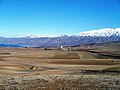 Malatya's Kale district and the Southeastern Taurus
 -


Geology
editThe Taurus Mountains were formed by the collision of theAfricanandEurasiantectonic plates.The predominant underlying rock islimestone.In the Aladaglar and Bolkar mountains, limestone has eroded to formkarsticlandscapes ofwaterfalls,underground rivers,and some of the largestcavesofAsia.TheManavgat Riveroriginates on the southern slopes of the Beydaglari range.[4]
Climate
editThe mountains have aMediterranean climate,with dry summers and rainy winters. Temperatures vary with elevation, with warm winters on the lower coastal slopes and cold winters in the high mountains and in the interior.[5]
Flora and fauna
editAt lower elevations, the predominant vegetation forest and woodland of evergreen oaks andTurkish pine(Pinus brutia), and areas ofmaquis shrubland.Above 1200 meters elevation are montane forests ofblack pine(Pinus nigra),Lebanon cedar(Cedrus libani),Taurus fir(Abies cilicica), andjuniper(Juniperusspp.). The high peaks are home to alpine meadows.[5]
History
edit
Pre-history and early Roman period
editThe bull was commonly the symbol and depiction ofancient Near Easternstorm gods,henceTaurusthe bull, and hence the name of the mountains. The mountains are a place of many ancient storm-god temples.[6]Torrential thunderstorms in these mountains were deemed by the ancient Syrians to be the work of the storm-god Adad to make theTigrisandEuphratesrivers rise and flood and thereby fertilise their land.[7]TheHurrians,probably originators of the variousstorm-godsof the ancient Near East, were a people whom modern scholars place in the Taurus Mountains at their probable earliest origins.
ABronze Agearchaeological site, where early evidence oftinminingwas found, is atKestel.[8]The pass known in antiquity as theCilician Gatescrosses the range north ofTarsus.
The Amanus range in southern Turkey is where the Taurus Mountains are pushed up as three tectonic plates come together. The Amanus is a natural frontier: west isCilicia,east is Syria. There are several passes, like theAmanian Gate (Bahçe Pass),which are of great strategical importance. In 333 BC at theBattle of Issus,Alexander the GreatdefeatedDarius IIIin the foothills along the coast between these two passes.[9]In the Second Temple period, Jewish authors seeking to establish with greater precision the geographical definition of thePromised Land,began to construeMount Horas a reference to the Amanus range of the Taurus Mountains, which marked the northern limit of theSyrian plain.[10]
Late Roman period to present
editDuringWorld War I,the German and Turkish railway system through the Taurus Mountains proved to be a major strategic objective of the Allies. This region was specifically mentioned as a strategically controlled objective slated for surrender to the Allies in theArmistice,which ended hostilities against theOttoman Empire.[11]
Attractions
editIn addition to hiking and mountain climbing,[3]there are twoski resortson the mountain range, one atDavrasabout 25 km (16 mi) from the two nearest towns ofEgirdirandIsparta,the second isSaklıkent40 km (25 mi) from the city ofAntalya.
TheVarda Viaduct,situated on the railway linesKonya-Adanaat Hacıkırı village inAdana Province,is a 98-metre-high (322 ft) railway bridge constructed in the 1910s byGermans.
See also
editReferences
edit- ^"Toros".Index Anatolicus(in Turkish).Retrieved1 February2023.
- ^İçel Sanat Külübü Aylık Bülteni, Ekim 1995 – 40. Sayı
- ^abc"Mountaineering in Turkey"All About Turkey
- ^"Manavgat River Water as a Limited but Alternative Water Resource for Domestic Use in Middle East"(PDF).Archived from the original on 2008-02-27.Retrieved2008-02-16.
- ^ab"Southern Anatolian montane conifer and deciduous forests".Terrestrial Ecoregions.World Wildlife Fund.
- ^Ravinell, Alberto and Green, WhitneyThe Storm-god in the Ancient Near East,p.126.ISBN1-57506-069-8
- ^Saggs, H.W.F.The greatness that was Babylon: a survey of the ancient civilization of the Tigris-Euphrates Valley,Sidgwick & Jackson, 2nd Revised edition, 1988, p.380.ISBN0283996234
- ^Yener, K.A. (2000)The Domestication of Metals: The Rise of Complex Metal Industries in AnatoliaBrill, Leiden,ISBN90-04-11864-0p. 91
- ^"Amanus Mountains".Livius - Places.Livius.org -Jona Lendering.26 March 2014.Retrieved21 July2015.
- ^Bechard, Dean Philip (1 January 2000).Paul Outside the Walls: A Study of Luke's Socio-geographical Universalism in Acts 14:8-20.Gregorian Biblical BookShop. pp.203–205.ISBN978-88-7653-143-9.
In the Second Temple period, when Jewish authors were seeking to establish with greater precision the geographical definition of the Land, it became customary to construe "Mount Hor" of Num 34:7 as a reference to the Amanus range of the Taurus Mountains, which marked the northern limit of the Syrian plain (Bechard 2000, p. 205, note 98.)
- ^Price, Ward (16 December 1918) "Danger in Taurus Tunnels"New York Times
External links
edit- map of Eurasiashowing Taurus Mountain ranges