Tripoli(Greek:Τρίπολη,Trípoli,KatharevousaΤρίπολις,Trípolis) is a city in the central part of thePeloponnese,inGreece.It is the capital of thePeloponnese regionas well as of the regional unit ofArcadia.The homonymous municipality had 44,165 inhabitants in 2021.[2]
Tripoli
Τρίπολη | |
|---|---|
 Clockwise from top:Panoramic view of the City of Tripoli,Saint Basil Cathedralin downtown Tripoli,Railway Station of Tripoli,Malliaropoulio Municipal Theater, and theCourt House of Tripoliwith theAreos Squarein front of it. | |
 Tripoli Location within the region  | |
| Coordinates:37°31′N22°23′E/ 37.517°N 22.383°E | |
| Country | Greece |
| Administrative region | Peloponnese |
| Regional unit | Arcadia |
| Government | |
| • Mayor | Konstantinos Tzioumis[1](since 2019) |
| Area | |
| • Municipality | 1,475.8 km2(569.8 sq mi) |
| • Municipal unit | 119.3 km2(46.1 sq mi) |
| Elevation | 655 m (2,149 ft) |
| Population (2021)[2] | |
| • Municipality | 44,165 |
| • Density | 30/km2(78/sq mi) |
| • Municipal unit | 33,026 |
| • Municipal unit density | 280/km2(720/sq mi) |
| • Community | 30,448 |
| Time zone | UTC+2(EET) |
| • Summer (DST) | UTC+3(EEST) |
| Postal code | 221 00 |
| Area code(s) | 2710 |
| Website | www.tripolis.gr |
Etymology
editIn the Middle Ages the place was known as Drobolitsa, Droboltsá, or Dorboglitza, either from the Greek Hydropolitsa, 'Water City' or perhaps from theSouth Slavicfor 'Plain of Oaks'.[3][4]The association made by 18th- and 19th-century scholars with the idea of the "three cities"(Τρίπολις, τρεις πόλεις" three cities ": variously Callia, Dipoena and Nonacris, mentioned byPausaniaswithout geographical context,[5]or Tegea, Mantineia and Pallantium, orMouchli,Tegea and Mantineia[6]or Nestani, Mouchli and Thana), were consideredparetymologiesby G.C. Miles.[7]An Italian geographical atlas of 1687[8]notes the fort ofGoriza e Mandi et Dorbogliza;a subsequent Italian geographical dictionary of 1827 attributes the name Dorbogliza to the ruins of Mantineia (Mandi) and states that it is located north ofTripolizza.[9]In 1463, it was spelled Droboliza and existed in ruins. The Ottoman Turks would later refer to the town and district as Tripoliça, Trepoliça, and Trapoliça.[citation needed]
History
edit
Little is known about Drobolitza, but it is included in a list of abandoned Byzantine sites from 1467, corresponding with the years after Mehmed's conquest of this part of Greece.[10]However, following theOttomanconquest ofMorea,it seems that the cultural and administrative centre of the Tegean plain was moved from Mouchli to Drobolitza. This was development occurring some years after the conquest, sometime after 1467. After 1540, the focus seems to have changed from the fortress itself, to the settlement below it calledTarabluca,that would be the next political centre of the plain.[11]French archaeologist visited the ruins of Tarabluca in 1829, and could still observe the ruins of Drobolitza at this time.
In spring 1770 during a Greek uprising known asOrlov Revolt,the revolutionary armies were halted out of Tripolitsa. In retaliation for the Greek uprising, Albanian mercenaries of the Ottomans slaughtered 3,000 Greeks in a few hours upon entering the city. Total massacre and destruction of the city was avoided after intervention of Osman bey, leader of the Albanian mercenaries.[12]
Before theGreek War of Independence,under the Ottoman name of "Tripoliçe", it was one of the Ottoman administrative centers in the Peloponnese (theMorea Eyalet,often called "pashalik of Tripolitsa" ) and had large Muslim and Jewish populations. Tripolis was one of the main targets of the Greek insurgents in the Greek War of Independence, who stormed it on 17 October 1821, following the bloodysiege of Tripolitsa,and exterminated the Muslim and Jewish populations.[13][14]
Ibrahim Pasharetook the city on June 22, 1825, after it had been abandoned by the Greeks. Before he evacuated the Peloponnese in early 1828, he destroyed the city and tore down its walls.[15]
After the independent Greek state was established in 1830, the old Ottoman buildings of Tripolizza, such as the walls, were completely destroyed or demolished.
Tripoli was renamed and rebuilt and was developed as one of the main cities of theKingdom of Greece,serving as the capital of theArcadiadistrict. During the 19th and the 20th centuries the city emerged to be the administrative, economic, commercial and transportation center of central and south Peloponnese.[16]
Geography and climate
editThe city of Tripoli has a hot-summerMediterranean climate(Köppen:Csa). Ιt is located in the center of thePeloponnese,at the western border of a large basin (apoljeat about 650 m in altitude, a length of ca. 30 km and a width between 12,5 and 2,5 km). The city is today the capital of the regional unit Arcadia (residents, city alone, ca. 30 000, district with hinterland ca. 47500,2011 Greek census). At its west the city borders the thickly wooded mountain-area “Mainalo”.The Tripoli Basin has gradually been rainwater regulated (mainly after 1945) and turned into farmland. In the southwest floods, which appear in the basin occasionally after rainy winters, as in 2003, formed the temporaryLake Taka.This lake was regulated by a new pond, to retain water for irrigation.
Because of its inland location and high altitude, Tripoli's climate has somecontinentalcharacteristics, such as some very cold lows during the winter months. Summer temperatures can exceed 38 °C (100 °F) and in winter temperatures below −10 °C (14 °F) have been observed on several occasions. Snow or sleet can occur several times between November and early April.
Its main plazas are aligned with the main street and with a highway linking toPyrgosandPatras.One of them is named Kennedy, the other is named Georgiou B' (George II). The southern part has its main street named Washington. The main section of the city is enclosed around the castle walls that were built during theOttomanoccupation ofGreece.An industrial park has been built in the southwest.
| Climate data for Tripolis (1957–2010) | |||||||||||||
|---|---|---|---|---|---|---|---|---|---|---|---|---|---|
| Month | Jan | Feb | Mar | Apr | May | Jun | Jul | Aug | Sep | Oct | Nov | Dec | Year |
| Record high °C (°F) | 20.4 (68.7) |
24.2 (75.6) |
25.4 (77.7) |
29.8 (85.6) |
36.6 (97.9) |
39.8 (103.6) |
42.2 (108.0) |
39.8 (103.6) |
35.4 (95.7) |
33.8 (92.8) |
26.8 (80.2) |
22.6 (72.7) |
42.2 (108.0) |
| Mean daily maximum °C (°F) | 9.6 (49.3) |
10.5 (50.9) |
13.3 (55.9) |
17.4 (63.3) |
23.0 (73.4) |
28.0 (82.4) |
30.4 (86.7) |
30.5 (86.9) |
26.2 (79.2) |
20.7 (69.3) |
15.5 (59.9) |
10.9 (51.6) |
19.7 (67.4) |
| Daily mean °C (°F) | 5.1 (41.2) |
5.7 (42.3) |
8.0 (46.4) |
11.9 (53.4) |
17.0 (62.6) |
21.9 (71.4) |
24.5 (76.1) |
23.9 (75.0) |
20.1 (68.2) |
14.4 (57.9) |
10.0 (50.0) |
6.7 (44.1) |
14.1 (57.4) |
| Mean daily minimum °C (°F) | 0.7 (33.3) |
1.0 (33.8) |
2.4 (36.3) |
4.9 (40.8) |
8.3 (46.9) |
12.0 (53.6) |
14.4 (57.9) |
14.6 (58.3) |
11.4 (52.5) |
8.1 (46.6) |
4.7 (40.5) |
2.4 (36.3) |
7.1 (44.7) |
| Record low °C (°F) | −17.0 (1.4) |
−15.8 (3.6) |
−16.0 (3.2) |
−4.0 (24.8) |
−0.2 (31.6) |
4.0 (39.2) |
7.6 (45.7) |
7.8 (46.0) |
0.4 (32.7) |
−2.6 (27.3) |
−5.8 (21.6) |
−11.0 (12.2) |
−17.0 (1.4) |
| Averageprecipitationmm (inches) | 103.6 (4.08) |
89 (3.5) |
74.8 (2.94) |
53.9 (2.12) |
37.6 (1.48) |
23.3 (0.92) |
19.4 (0.76) |
19.3 (0.76) |
29.2 (1.15) |
66.1 (2.60) |
108.8 (4.28) |
125.8 (4.95) |
750.8 (29.54) |
| Average precipitation days | 13.7 | 12.8 | 12.5 | 11.5 | 9.2 | 6.1 | 4.0 | 3.3 | 4.8 | 9.8 | 11.9 | 15.6 | 115.2 |
| Averagerelative humidity(%) | 76.1 | 74.4 | 69.3 | 62.5 | 57.0 | 47.4 | 44.1 | 45.9 | 54.5 | 75.4 | 77.4 | 77.5 | 63.5 |
| Source: Hellenic National Meteorological Service[17] | |||||||||||||
Surrounding area and geology
edit

In the large Tripoli Basin and in vast parts of the wider geological formations of the Arcadian Highlandtectonics[18]in the dominant carbonate rock "Tripoliza" of the Peloponnese developed a special topography: There are several plains, "intra mountainous basins", even "closed basins": Besides small basins, there are the Tripoli-Basin, the "Argon Pedion"(an almost separated side basin in the northeast of Tripoli), the Basin ofLevidiand the Basin ofVlacherna Arcadia/Hotoussa/Kandila).[19]
The peculiarity of all plains and basins in Arcadia is the coincidence with intensivekarstification:Water seeps into the underground, rather than eroding and draining the topography by surface waterways. All drainage runs throughponors(in Greek: καταβόθρες) and subterranean waterways.[20]There are 45 ponors in the above named basins.[21]There are 7 ponors around Lake Taka. When winter rains are heavy, the ground is flooded or temporary lakes form, even today, as drainage through ponors is often slow which causes land cultivation delays.
Municipality
edit

The municipality of Tripoli was formed at the 2011 local government reform by merging these 8 former municipalities, that became municipal units:[22]
The municipality has an area of 1,475.805 km2,the municipal unit 119.287 km2.[23]
Subdivisions
editThe municipal unit of Tripoli is subdivided into these communities:[24]
- Agios Vasileios
- Agios Konstantinos
- Evandro
- Makri
- Merkovouni
- Pallantio
- Pelagos
- Perthori
- Skopi
- Thanas
- Tripoli
Education
editTripoli is the flagship campus of theUniversity of the Peloponnese,founded in 2000.
UoP Tripoli is the location of the School ofEconomy,ManagementandInformatics,composed of the Department ofEconomicsand the Department of Informatics andTelecommunications.[25]
Transportation
edit
Because it is at the centre of the Peloponnese, Tripolis is a transportation hub.Corinthis 75 kilometres (47 miles) NE,Pyrgos145 kilometres (90 mi) E,Patras144 km (89 mi) NW,Kalamata65 km (40 mi) SW, andSparti60 km (37 mi) S.
Tripoli is mainly accessed from Athens and the rest of Greece through theA7 toll motorway,which runs northbound towards Corinth and southbound to Kalamata. An alternative toll-free route is theGR-7which used to be the main highway to Tripoli before the construction of the motorway. The city is also accessed byGR-74andGR-76fromPyrgosand byGR-39fromSparta.
Tripoli is served by the metre gauge railway line from Corinth to Kalamata of theHellenic Railways Organisation(OSE). The line was renovated and passenger services toÁrgosand Corinth, which had been suspended for a few years, were reinstated in 2009. However, in December 2010 services ceased again due to the general suspension of railway services in the Peloponnese.
Military
editTripoli is home to the two largest Armed Forces bootcamps in Greece, one operated by theHellenic Armyand one by theHellenic Air Force:the 251st Army TrainingBattalionand the 124th Basic TrainingWing.
Sports
editTripoli hosts three sport clubs with presence in the higher national divisions in Greek football and basketball. These clubs are shown below.
| Club | Founded | Sports | Achievements |
|---|---|---|---|
| Panarkadikos F.C. | 1927 | Football | Earlier presence in Beta Ethniki[26][circular reference] |
| Asteras Tripolis | 1931 | Football | Presence inSuper League Greece |
| Arkadikos B.C. | 1976 | Basketball | Presence inA2 Ethniki |
In popular culture
editThe siege of Tripolitsa was made famous in the folk (Δημοτικό) song "40 παλικάρια από την Λιβαδειά" (Forty lads from Livadeia)[27]
Historical population
edit| Year | Community | Municipal unit | Municipality |
|---|---|---|---|
| 1981 | 21,337 | – | – |
| 1991 | 22,429 | 26,432 | – |
| 2001 | 25,520 | 28,976 | – |
| 2011 | 30,912 | 33,785 | 47,254 |
| 2021 | 30,448 | 33,026 | 44,165 |
Notable people
edit

- Theodoros Kolokotronis(3 April 1770 – 4 February 1843), general and pre-eminent leader of the Greek War of Independence
- Epameinontas Deligeorgis(1829–1879), Prime Minister of Greece
- Konstantinos Georgakopoulos(1890–1978), lawyer and politician, Prime Minister of Greece
- Kostas Karyotakis(1896–1928), poet
- Ioannis Kossos,sculptor
- Yiannis Kouros(1956), ultramarathon runner
- Konstantinos Manetas(1879–1960), general and politician
- Theodoros Manetas(1881–1947), general and politician
- Alexandros Papanastasiou(1876–1936), politician and sociologist,Prime Minister of Greece
- Dr. Giorgos Peponis,medical practitioner, sports administrator and former captain of theAustralian Rugby Leagueteam was born in the city in 1953
- Petros Tatoulis(1953), politician
- Semni Karouzou(1897–1994), archaeologist and curator
International relations
editTwin towns — sister cities
editTripoli, Greece istwinnedwith:
Gallery
edit-
 "Death of a Greek soldier during the siege of Tripolizza" byHenri Serrur
 -
 A statue ofTheodoros Kolokotronis
 -
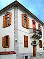
 Agios Vasilios (St Basil), Tripoli's cathedral. Facade built withDolianamarble
 -
 House ofKostas Karyotakis
 -
 The archaeological museum
 -
 A street in Tripoli
 -
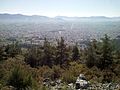 Panoramic view of Tripoli


References
edit- ^Municipality of Tripoli, Municipal elections – October 2023,Ministry of Interior
- ^ab"Αποτελέσματα Απογραφής Πληθυσμού - Κατοικιών 2021, Μόνιμος Πληθυσμός κατά οικισμό"[Results of the 2021 Population - Housing Census, Permanent population by settlement] (in Greek). Hellenic Statistical Authority. 29 March 2024.
- ^R. M. Dawkins,The Place-names of Later Greece,inTransactions of the Philological Society,November 1933, p. 19–20
- ^George C. Miles,The Athenian Agora,vol. 9, 1962, p 12 (Miles considers "Hydropolitsa" a popularization)
- ^Pausanias, Description of Greece, English Translation by W.H.S. Jones + H.A. Ormerod, London, 1918, Arcadia, 8.27.4
- ^Leake,Travels in the Morea,Volume 2
- ^George C. Miles,The Athenian Agoravol.9, 1962, p 12
- ^"(Title unset) - Barry Lawrence Ruderman Antique Maps Inc".www.raremaps.com.
- ^Nuovo Dizionario Geografico Universale,Cavagna Sanguliani, 1827, page 827
- ^Panagiotopoulos, B. (1987), 243.
- ^J. Bakke (2008),Forty Rivers: Landscape and Memory in the District of Ancient Tegea(Bergen: University of Bergen), 184.
- ^Nikolaou, Georgios (1997). "Islamisations et Christianisations dans le Peloponnese (1715- 1832)".Didaktorika.gr.Universite des Sciences Humaines - Strasbourg II: 181.doi:10.12681/eadd/8139.hdl:10442/hedi/8139.
Les Albanais, qui avaient pris l'initiative des opérations, sont entrés à Tripolitsa, ont massacre les habitants et se sont adonnés au pillage. On évalue qu'en l'espace de quelques heures seulement 3.000 Grecs furent tués. Grâce à l'intervention du chef des Albanais Osman bey, l'extermination et la dévastation ne furent pas totales.
- ^Nevill Forbes,et al.,The Balkans(full text)
- ^Theodoros Kolokotronis,Apomnimoneumata
- ^John Hartley,Researches in Greece and the Levant,p 341
- ^"Visit Greece | TRIPOLI".www.visitgreece.gr.
- ^"Mean Tripolis Climatic Averages".Hellenic National Meteorological Service.Retrieved9 December2020.
- ^Jacobshagen, Volker (ed), Geologie von Griechenland, Beiträge zur regionalen Geologie der Erde, Stuttgart, 1986. In German/English
- ^I. Mariolakos (Greek geologist) describes these geological phenomena of Arcadia and relates them to local ancient history and myths: Mariolakos, Ilias. Geomythological Sites and Prehistoric geotechnical and hydraulic Works in Arkadia, 12th International Congress of the Geological Society of Greece, Field Trip Guide, Patras May 2010. In Greek. See also “External Links”
- ^Ford, D. C. and Williams, P., Karst Hydrogeology and Geomorphology, Chichester, 2007, 4th, rev. ed.
- ^42 alone in the Tripoli Basin. Some are inactive now): Morfis, A. (Athens), Zojer, H. (Graz). Karst Hydrogeology of the Central and Eastern Peloponnesus (Greece). Steirische Beiträge zur Hydrogeologie 37/38. Graz 1986. Plate 9, 4.6.2, p. 186
- ^"ΦΕΚ A 87/2010, Kallikratis reform law text"(in Greek).Government Gazette.
- ^"Population & housing census 2001 (incl. area and average elevation)"(PDF)(in Greek). National Statistical Service of Greece. Archived fromthe original(PDF)on 2015-09-21.
- ^"ΦΕΚ B 1292/2010, Kallikratis reform municipalities"(in Greek).Government Gazette.
- ^"Location".www.uop.gr.Retrieved2021-12-16.
- ^Football League (Greece)#Beta Ethniki
- ^"Vangelis and Irene Papas lyrics - Odes lyrics (English translation)".www.vangelislyrics.com.
External links
edit- [1]Mariolakos, Geomythological Sites in Arcadia in Greek
- http://arcadia.ceid.upatras.gr/arkadia/places/trip/tripoli.htmArchived2011-07-09 at theWayback Machine(in Greek)