TheUral Mountains(/ˈjʊərəl/YOOR-əl;Russian:Уральские горы,romanized:Urál'skiye góry,IPA:[ʊˈralʲskʲɪjəˈɡorɨ]),[a]or simplythe Urals,are amountain rangeinEurasiathat runs north–south mostly through theRussian Federation,from the coast of theArctic Oceanto the riverUraland northwesternKazakhstan.[1] The mountain range forms part of theconventional boundarybetween the continents ofEuropeandAsia,marking the separation betweenEuropean RussiaandSiberia.Vaygach Islandand the islands ofNovaya Zemlyaform a further continuation of the chain to the north into the Arctic Ocean. The average altitudes of the Urals are around 1,000–1,300 metres (3,300–4,300 ft), the highest point beingMount Narodnaya,which reaches a height of 1,894 metres (6,214 ft).[2]
| Ural Mountains | |
|---|---|
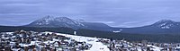
 Landscape in the northern part of the Ural Mountains (Khanty-Mansi Autonomous Okrug) | |
| Highest point | |
| Peak | Mount Narodnaya |
| Geography | |

| |
| Countries | RussiaandKazakhstan |
| Range coordinates | 60°N59°E/ 60°N 59°E |
| Geology | |
| Orogeny | Uralian orogeny |
| Age of rock | Carboniferous |
| Type of rock | Metamorphic,igneous,sedimentary |
The mountains lie within theUralgeographical region and significantly overlap with theUral Federal Districtand theUral economic region.Their resources include metal ores, coal, and precious and semi-precious stones. Since the 18th century, the mountains have contributed significantly to the mineral sector of theRussian economy.The region is one of the largest centres of metallurgy and heavy industry production in Russia.[3]
Etymology
editAs attested bySigismund von Herberstein,in the 16th century, Russians called the Ural range by a variety of names derived from the Russian words for rock (stone) and belt. The modern Russian name for the Urals (Урал,Ural), first appearing in the 16th–17th century during theRussian conquest of Siberia,was initially applied to its southern parts and gained currency as the name of the entire range during the 18th century. It might have been borrowed from eitherTurkic"stone belt"[4](Bashkir,where the same name is used for the range), orOb-Ugric.[5]From the 13th century inBashkortostan,there has been alegend about a hero named Uralwho sacrificed his life for the sake of his people who then poured a stone pile over his grave, which later turned into the Ural Mountains.[6][7][8]Possibilities include Bashkirүр"elevation; upland" andMansiур ала"mountain peak, top of the mountain",[9]V.N. Tatischevbelieves that thisoronymis set to "belt" and associates it with the Turkic verb oralu- "gird".[9]I.G. Dobrodomov suggests a transition fromAralto Ural explained on the basis of ancientBulgar-Chuvashdialects. Geographer E.V. Hawks believes that the name goes back to the Bashkir folkloreUral-Batyr.[9]TheEvenkgeographical termera"mountain" has also been theorized.[9](cf also Ewenkī ürǝ-l (pl.) "mountains" ) Finno-Ugrist scholars consider Ural deriving from theOstyakwordurrmeaning "chain of mountains".[10]Turkologists,on the other hand, have achieved majority support for their assertion that 'ural' in Tatar means a belt, and recall that an earlier name for the range was 'stone belt'.[11]
History
edit
As merchants from the Middle East traded with theBashkirsand other people living on the western slopes of the Ural as far north asGreat Perm,since the 10th century, medievalmideastern geographershad been aware of the existence of the mountain range in its entirety, stretching as far as the Arctic Ocean in the north. The first Russian mention of the mountains to the east of theEast European Plainis provided by thePrimary Chronicle,where it describes theNovgorodianexpedition to the upper reaches of thePechorain the year 1096. During the next few centuries, Novgorodians engaged infur tradingwith the local population and collected tribute fromYugraand Great Perm, slowly expanding southwards. The rivers,ChusovayaandBelaya,were first mentioned in the chronicles of 1396 and 1468, respectively. In 1430, the town ofSolikamsk(Kama Salt) was founded on theKamaat the foothills of the Ural, where salt wasproduced in open pans.Ivan III of Moscowcaptured Perm, Pechora and Yugra from the declining Novgorod Republic in 1472. With the excursions of 1483 and 1499–1500 across the Ural, Moscow managed to subjugate Yugra completely.

Nevertheless, around the early 16th century, Polish geographer,Maciej of Miechów,in his influentialTractatus de duabus Sarmatiis(1517) argued that there were no mountains in Eastern Europe at all, challenging the point of view of some authors of Classical antiquity, which were popular during theRenaissance.Only after Sigismund von Herberstein in hisNotes on Muscovite Affairs(1549) had reported, following Russian sources, that there are mountains behind the Pechora and identified them with theRiphean MountainsandHyperboreansof ancient authors, did the existence of the Ural, or at least of its northern part, become firmly established in theWestern geography.The Middle and Southern Ural were still largely unavailable and unknown to the Russian or Western European geographers.

In the 1550s, after theTsardom of Russiahad defeated theKhanate of Kazanand proceeded to gradually annex the lands of the Bashkirs, the Russians finally reached the southern part of the mountain chain. In 1574, they foundedUfa.The upper reaches of the Kama and Chusovaya in the Middle Ural, still unexplored, as well as parts of Transuralia still held by the hostileSiberian Khanate,were granted to theStroganovsby several decrees of the tsar in 1558–1574. The Stroganovs land provided the staging ground forYermak'sincursion into Siberia.Yermak crossed the Ural from the Chusovaya to theTagilaround 1581. In 1597, Babinov's road was built across the Ural from Solikamsk to the valley of theTura,where the town ofVerkhoturye(Upper Tura) was founded in 1598. Customs was established in Verkhoturye shortly thereafter and the road was made the only legal connection between European Russia and Siberia for a long time. In 1648, the town ofKungurwas founded at the western foothills of the Middle Ural. During the 17th century, the first deposits ofironandcopperores,mica,gemstonesand other minerals were discovered in the Ural.
Iron and coppersmeltingworksemerged. In particular, theGumyoshevsky minewas established in 1702 at an ancient copper deposit known sinceBronze Age— so-called "legendary"Copper Mountainwhich also producedmalachite.Mining intensified particularly quickly during the reign ofPeter I of Russia.In 1720–1722, he commissionedVasily Tatishchevto oversee and develop the mining and smelting works in the Ural. Tatishchev proposed a new copper smelting factory inYegoshikha,which would eventually become the core of the city ofPermand a new iron smelting factory on theIset,which would become the largest in the world at the time of construction and give birth to the city ofYekaterinburg.Both factories were actually founded by Tatishchev's successor,Georg Wilhelm de Gennin,in 1723. Tatishchev returned to the Ural on the order ofEmpress Annato succeed de Gennin in 1734–1737. Transportation of the output of the smelting works to the markets of European Russia necessitated the construction of theSiberian Routefrom Yekaterinburg across the Ural to Kungur and Yegoshikha (Perm) and further to Moscow, which was completed in 1763 and rendered Babinov's road obsolete. In 1745, gold was discovered in the Ural atBeryozovskoyeand later at other deposits. It has been mined since 1747.
The first ample geographic survey of the Ural Mountains was completed in the early 18th century by the Russian historian and geographer Vasily Tatishchev under the orders of Peter I. Earlier, in the 17th century, rich ore deposits were discovered in the mountains and their systematic extraction began in the early 18th century, eventually turning the region into the largest mineral base of Russia.[1][6]
One of the first scientific descriptions of the mountains was published in 1770–71. Over the next century, the region was studied by scientists from a number of countries, including Russia (geologistAlexander Karpinsky,botanistPorfiry Krylovand zoologistLeonid Sabaneyev), the United Kingdom (geologist SirRoderick Murchison), France (paleontologistÉdouard de Verneuil), and Germany (naturalistAlexander von Humboldt,geologistAlexander Keyserling).[1][12]In 1845, Murchison, who had according toEncyclopædia Britannica"compiled the first geologic map of the Ural in 1841",[1]publishedThe Geology of Russia in Europe and the Ural Mountainswith de Verneuil and Keyserling.[12][13]
The first railway across the Urals had been built by 1878 and linked Perm to Yekaterinburg viaChusovoy,KushvaandNizhny Tagil.In 1890, a railway linked Ufa andChelyabinskviaZlatoust.In 1896, this section became a part of theTrans-Siberian Railway.In 1909, yet another railway connecting Perm and Yekaterinburg passed through Kungur by the way of the Siberian Route. It has eventually replaced the Ufa – Chelyabinsk section as the main trunk of the Trans-Siberian railway.
The highest peak of the Ural,Mount Narodnaya,(elevation 1,895 m [6,217 ft]) was identified in 1927.[14]

During theSoviet industrializationin the 1930s, the city ofMagnitogorskwas founded in the South-Eastern Ural as a center of iron smelting andsteelmaking.During theGerman invasion of the Soviet Unionin 1941–1942, the mountainsbecame a key element in Nazi planningfor the territories which they expected to conquer in the USSR. Faced with the threat of having a significant part of the Soviet territories occupied by the enemy, the government evacuated many of the industrial enterprises of European Russia and Ukraine to the eastern foothills of the Ural, considered a safe place out of reach of the German bombers and troops. Three gianttank factorieswere established at theUralmashin Sverdlovsk (as Yekaterinburg used to be known),Uralvagonzavodin Nizhny Tagil, andChelyabinsk Tractor Plantin Chelyabinsk. After the war, in 1947–1948, Chum –Labytnangirailway, built with the forced labor ofGulaginmates,crossed the Polar Ural.
Mayak,150 kilometres (93 mi) southeast ofYekaterinburg,was a center of the Soviet nuclear industry[1][15][16][17]and site of theKyshtym disaster.[16][18]
Geography and topography
edit
The Ural Mountains extend about 2,500 km (1,600 mi) from theKara Seato theKazakh Steppealong the border of Kazakhstan. Vaygach Island and the island of Novaya Zemlya form a further continuation of the chain on the north. Geographically this range marks the northern part of the border between Europe and Asia. Its highest peak is Mount Narodnaya, approximately 1,895 m (6,217 ft) in elevation.[1]Transverse faults divide the mountain chain into seven major units, each of which has its own typical pattern of mountain ridges. From north to south, these are the Pay-Khoy, Zapolyarnyy, Pripolyarnyy, Polyarnyy, Severnyy, Sredniy, Yuzhnny Ural and Mugodzhary. The average altitudes of the Urals are around 1,000–1,300 m (3,300–4,300 ft), the highest point being Narodnaya peak in the Pripolyarnyy Ural which reaches a height of 1,894 metres (6,214 ft).[2]

By topography and other natural features, the Urals are divided, from north to south, into the Polar (or Arctic), Nether-Polar (or Sub-Arctic), Northern, Central and Southern parts.
Polar Ural
editThePolar Uralsextend for about 385 kilometers (239 mi) from Mount Konstantinov Kamen in the north to the river Khulga in the south; they have an area of about 25,000 km2(9,700 sq mi) and a strongly dissected relief. The maximum height is 1,499 m (4,918 ft) atMount Payerand the average height is 1,000 to 1,100 m (3,300 to 3,600 ft).
The mountains of the Polar Ural have exposed rock with sharp ridges, though flattened or rounded tops are also found.[1][6]
Nether-polar Ural
edit
The Nether-Polar Ural are higher, and up to 150 km (93 mi) wider than the Polar Urals. They include the highest peaks of the range: Mount Narodnaya (1,895 m (6,217 ft)),Mount Karpinsky(1,878 m (6,161 ft)) andManaraga(1,662 m (5,453 ft)). They extend for more than 225 km (140 mi) south to theShchugor.The many ridges are sawtooth shaped and dissected by river valleys. Both Polar and Nether-Polar Urals are typically Alpine; they bear traces ofPleistoceneglaciation, along with permafrost and extensive modern glaciation, including 143 extant glaciers.[1][6]
Northern Ural
editThe Northern Ural consist of a series of parallel ridges up to 1,000–1,200 m (3,300–3,900 ft) in height and longitudinal hollows. They are elongated from north to south and stretch for about 560 km (350 mi) from the riverUsa.Most of the tops are flattened, but those of the highest mountains, such as Telposiz, 1,617 m (5,305 ft) and Konzhakovsky Stone, 1,569 m (5,148 ft) have a dissected topography. Intensive weathering has produced vast areas of eroded stone on the mountain slopes and summits of the northern areas.[1][6]
Central Ural
editThe Central Ural are the lowest part of the Ural, with smooth mountain tops, the highest mountain being 994 m (3,261 ft) (Basegi); they extend south from the riverUfa.[6]
Southern Ural
editThe relief of the Southern Ural is more complex, with numerous valleys and parallel ridges directed south-west and meridionally. The range includes theIlmensky Mountainsseparated from the main ridges by theMiass.The maximum height is 1,640 m (5,380 ft) (Mount Yamantau) and the width reaches 250 km (160 mi). Other notable peaks lie along theIremelmountain ridge (Bolshoy Iremel and Maly Iremel) andNurgush.The Southern Urals extend some 550 km (340 mi) up to the sharp westward bend of the river Ural and terminate in theGuberlin Mountainsand finally in the wideMughalzhar Hills.[1]

|

|

|

|
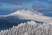
| Mountain formation near Saranpaul, Nether-Polar Urals | Rocks in a river, Nether-Polar Urals | Big Iremel Mountain | Entry toIgnateva Cave,South Urals |
Geology
edit
The Urals are among the world's oldest extantmountain ranges.Some have estimated the age to be 250 to 300 million years, the elevation of the mountains is unusually high. This estimate of the age of this formation is based upon the assumption that radioactive dating is an accurate method. The modes of radioactive dating are being contested. If C-14 is unstable but assumed to be stable the dating is wildly exagerated.[19]They formed during theUralian orogenydue to thecollisionof theeastern edgeof the supercontinentLaurasiawith the young andrheologicallyweak continent ofKazakhstania,which now underlies much of Kazakhstan and West Siberia west of theIrtysh,and interveningisland arcs.The collision lasted nearly 90 million years in the lateCarboniferous– earlyTriassic.[20][21][22][23]Unlike the other major orogens of thePaleozoic(Appalachians,Caledonides,Variscides), the Urals have not undergonepost-orogenic extensional collapseand are unusually well preserved for their age, being underlaid by a pronounced crustal root.[24][25]East and south of the Urals much of the orogen is buried beneath laterMesozoicandCenozoicsediments.[20]The adjacentPay-Khoy Ridgeto the north andNovaya Zemlyaare not a part of the Uralian orogen and formed later.
Many deformed andmetamorphosedrocks, mostly ofPaleozoicage, surface within the Urals. Thesedimentaryandvolcaniclayers arefoldedandfaulted.The sediments to the west of the Ural Mountains are formed oflimestone,dolomiteandsandstoneleft from ancient shallow seas. The eastern side is dominated bybasalts.[6]

The western slope of the Ural Mountains has predominantlykarst topography,especially in theSylvabasin, which is a tributary of theChusovaya.It is composed of severely eroded sedimentary rocks (sandstones and limestones) that are about 350 million years old. There are manycaves,sinkholesand underground streams. The karst topography is much less developed on the eastern slopes. The eastern slopes are relatively flat, with some hills and rocky outcrops and contain alternating volcanic and sedimentary layers dated to the middle Paleozoic Era.[6]Most high mountains consist of weather-resistant rocks such asquartzite,schistandgabbrothat are between 395 and 570 million years old. The river valleys are underlain by limestone.[1]
The Ural Mountains contain about 48 species of economically valuableoresand minerals. Eastern regions are rich inchalcopyrite,nickel oxide(e. g.Serov nickel deposit),gold,platinum,chromiteandmagnetiteores, as well as incoal(Chelyabinsk Oblast),bauxite,talc,fireclayand abrasives. The Western Urals contain deposits of coal, oil, natural gas (Ishimbay and Krasnokamsk areas) andpotassium salts.Both slopes are rich inbituminous coalandlignite,and the largest deposit of bituminous coal is in the north (Pechora field). The specialty of the Urals is precious and semi-precious stones, such asemerald,amethyst,aquamarine,jasper,rhodonite,malachiteanddiamond.Some of the deposits, such as the magnetite ores atMagnitogorsk,are already nearly depleted.[1][6]

|

|

|

|
| Andradite | Beryl | Platinum | Quartz |
Rivers and lakes
edit
Many rivers originate in the Ural Mountains. The western slopes south of the border between theKomi Republicand Perm Krai and the eastern slopes south of approximately 54°30'N drain into theCaspian Seavia the Kama and Ural basins. The tributaries of the Kama include theVishera,Chusovaya, and Belaya and originate on both the eastern and western slopes. The rest of the Urals drain into the Arctic Ocean, mainly via the Pechora basin in the west, which includes theIlych,Shchugor,and theUsa,and via theObbasin in the east, which includes theTobol,Tavda,Iset, Tura andSevernaya Sosva.The rivers are frozen for more than half the year. Generally, the western rivers have higher flow volume than the eastern ones, especially in the Northern and Nether-Polar regions. Rivers are slower in the Southern Urals. This is because of low precipitation and the relatively warm climate resulting in less snow and more evaporation.[1][6]
The mountains contain a number of deep lakes.[26]The eastern slopes of the Southern and Central Urals have most of these, among the largest of which are the Uvildy, Itkul, Turgoyak, and Tavatuy lakes.[6]The lakes found on the western slopes are less numerous and also smaller. Lake Bolshoye Shchuchye, the deepest lake in the Polar Urals, is 136 meters (446 ft) deep. Other lakes, too, are found in the glacial valleys of this region. Spas and sanatoriums have been built to take advantage of the medicinal muds found in some of the mountain lakes.[1][6]
Climate
editThe climate of the Urals is continental. The mountain ridges, elongated from north to south, effectively absorb sunlight thereby increasing the temperature. The areas west of the Ural Mountains are 1–2 °C (1.8–3.6 °F) warmer in winter than the eastern regions because the former are warmed by Atlantic winds whereas the eastern slopes are chilled by Siberian air masses. The average January temperatures increase in the western areas from −20 °C (−4 °F) in the Polar to −15 °C (5 °F) in the Southern Urals and the corresponding temperatures in July are 10 and 20 °C (50 and 68 °F). The western areas also receive more rainfall than the eastern ones by 150–300 mm (5.9–11.8 in) per year. This is because the mountains trap clouds from the Atlantic Ocean. The highest precipitation, approximately 1,000 mm (39 in), is in the Northern Urals with up to 1,000 cm (390 in) snow. The eastern areas receive from 500–600 mm (20–24 in) in the north to 300–400 mm (12–16 in) in the south. Maximum precipitation occurs in the summer: the winter is dry because of theSiberian High.[1][6]
Flora
edit
The landscapes of the Urals vary with both latitude and longitude and are dominated by forests and steppes. The southern area of the Mughalzhar Hills is a semidesert. Steppes lie mostly in the southern and especially south-eastern Urals. Meadow steppes have developed on the lower parts of mountain slopes and are covered withzigzagandmountain clovers,Serratulagmelinii,dropwort,meadow-grassandBromus inermis,reaching the height of 60–80 centimetres (24–31 in). Much of the land is cultivated. To the south, the meadow steppes become more sparse, dry and low. The steep gravelly slopes of the mountains and hills of the eastern slopes of the Southern Urals are mostly covered with rocky steppes. River valleys containwillow,poplarandcaraganashrubs.[6]
Forest landscapes of the Urals are diverse, especially in the southern part. The western areas are dominated by dark coniferous taiga forests which change to mixed and deciduous forests in the south. The eastern mountain slopes have light coniferous taiga forests. The Northern Urals are dominated by conifers, namelySiberian fir,Siberian pine,Scots pine,Siberian spruce,Norway spruceandSiberian larch,as well as bysilveranddowny birches.The forests are much sparser in the Polar Urals. Whereas in other parts of the Ural Mountains they grow up to an altitude of 1,000 metres (3,300 ft), in the Polar Urals thetree lineis at 250–400 metres (820–1,310 ft). The low polar forests are mixed with swamps, lichens, bogs and shrubs.Dwarf birch,mosses and berries (blueberry,cloudberry,black crowberry,etc.) are abundant. The forests of the Southern Urals are the most diverse in composition: here, together with coniferous forests are also abundant broadleaf tree species such asEnglish oak,Norway mapleand elm.[6]TheVirgin Komi Forestsin the northern Urals are recognized as aWorld Heritagesite.
Fauna
editThe forests of Urals are inhabited by animals typical of Eurosiberia, such as elk, brown bear, fox, wolf,wolverine,lynx,squirrel,Siberian chipmunk,flying squirrel,reindeerandsable(north only). The fauna of Polar Urals also includes species like Arctic Fox and lemmings. Because of the easy accessibility of the mountains there are no specifically mountainous species. In the Central Urals, one can see a rare mixture of sable and pine marten named kidus. In the Southern Urals,badgerandblack polecatare common. Reptiles and amphibians live mostly in the Southern and Central Ural and are represented by thecommon viper,lizardsandgrass snakes. Bird species of Northern, Middle and South Urals are represented byWestern Capercaillie,black grouse,hazel grouse,spotted nutcracker,Siberian Jay,CommonandOriental cuckoos.Unlike mammals, the highest peaks and plateaus of Northern and Southern Urals are inhabited by some mountainous or tundra avian species, likeGolden Plover,Dotterel,PtarmiganandWillow Grouse,in Polar Urals also by Rough-legged Buzzard and Snowy Owl.[1][6]
The steppes of the Southern Urals are dominated by hares and rodents such ashamsters,susliks,andjerboa.There are many birds of prey such aslesser kestrelandbuzzards.
Ecology
editThe continuous and intensive economic development of the last centuries has affected the fauna, and wildlife is much diminished around all industrial centers. During World War II, hundreds of factories were evacuated from Western Russia before the German occupation, flooding the Urals with industry. The conservation measures include establishing national wildlife parks.[1]There are ninestrict nature reservesin the Urals: theIlmen,the oldest one, mineralogical reserve founded in 1920 in Chelyabinsk Oblast,Pechora-Ilychin the Komi Republic,Bashkirand its former branchShulgan-Tashin Bashkortostan,Visimin Sverdlovsk Oblast,Southern Uralin Bashkortostan,Basegiin Perm Krai,Visherain Perm Krai andDenezhkin Kamenin Sverdlovsk Oblast.
The area has also been severely damaged by theplutonium-producing facilityMayak,opened in Chelyabinsk-40 (later called Chelyabinsk-65,Ozyorsk), in the Southern Ural, after World War II.[1]Its plants went into operation in 1948 and, for the first ten years, dumped unfiltered radioactive waste into the riverTechaandLake Karachay.[1][15][16]In 1990, efforts were underway to contain the radiation in one of the lakes, which was estimated at the time to expose visitors to 500milliremper day.[16]As of 2006, 500 mrem in the natural environment was the upper limit of exposure considered safe for a member of the general public in an entire year (though workplace exposure over a year could exceed that by a factor of 10).[17]Over 23,000 km2(8,900 sq mi) of land were contaminated in 1957 from a storage tank explosion, only one of several serious accidents that further polluted the region.[1]The1957 accidentexpelled 20 millioncuriesof radioactive material, 90% of which settled into the land immediately around the facility.[18]Although some reactors of Mayak were shut down in 1987 and 1990,[16]the facility keeps producing plutonium.[27]
Cultural significance
editThe Urals have been viewed by Russians as a "treasure box" of mineral resources, which were the basis for its extensive industrial development. In addition to iron and copper, the Urals were a source of gold,malachite,alexandrite,and other gems such as those used by the court jewellerFabergé.As Russians in other regions gather mushrooms or berries, Uralians gather mineral specimens and gems.Dmitry Mamin-Sibiryak(1852–1912) andPavel Bazhov(1879–1950), as well asAleksey Ivanovand Olga Slavnikova, post-Soviet writers, have written of the region.[28]
The region served as a military stronghold duringPeter the Great'sGreat Northern Warwith Sweden, during Stalin's rule when theMagnitogorsk Metallurgical Complexwas built and Russian industry relocated to the Urals during the Nazi advance at the beginning of World War II, and as the center of the Soviet nuclear industry during theCold War.Extreme levels of air, water, and radiological contamination andpollutionby industrial wastes resulted. Population exodus followed, and economic depression at the time of the collapse of the Soviet Union, but in post-Soviet times additional mineral exploration, particularly in the northern Urals, has been productive and the region has attracted industrial investment.[28]
Gallery
edit-
 Mount Iremel
 -
 Mount Iremel
 -
 Mount Iremel peak
 -
 Mount Yamantau
 -
 View from mount Yamantau second peak (Bolshaya Yamantau)
 -
 Forest around mount Yamantau
 -
 View of the two-peak mount Taganay
 -
 Mount Otkliknoy Greben
 -
 Taganay national park
 -
 Sunrise on Taganay


See also
editNotes
edit- ^Bashkir:Урал тауҙары,romanized:Ural tawźarı,pronounced[ʊˌɾɑɫtɑwðɑˈɾɤ];Kazakh:Орал таулары,romanized:Oral taulary,pronounced[woˌrɑɫtɑwɫɑˈrə]
References
edit- ^abcdefghijklmnopqrstUral MountainsArchived29 April 2015 at theWayback Machine,Encyclopædia Britannica on-line
- ^abEmbleton, Clifford (2016).Geomorphology of Europe.Macmillan Education UK. p. 404.ISBN9781349173464.[permanent dead link]
- ^Russian Regional Economic and Business Atlas.International Business Publications. August 2013. p. 42.ISBN9781577510291.
- ^Koryakova, Ludmila; Epimakhov, Andrey (2014).The Urals and Western Siberia in the Bronze and Iron Ages.Cambridge University Press. p. 338.ISBN978-1-139-46165-8.
- ^Фасмер, Макс.Этимологический словарь русского языка
- ^abcdefghijklmnop"Урал (географич.) (Ural (geographical))".Great Soviet Encyclopedia.Archivedfrom the original on 9 April 2022.Retrieved22 June2020.
- ^Koriakova, Ludmila; Epimakhov, Andrei (2007).The Urals and Western Siberia in the Bronze and Iron Ages.Cambridge University Press. p. 338.ISBN978-0-521-82928-1.
- ^Ural, toponymArchived12 August 2011 at theWayback MachineChlyabinsk Encyclopedia (in Russian)
- ^abcd"What is the Urals".Survinat.30 October 2014. Archived fromthe originalon 17 August 2018.
- ^Kropotkin, Peter Alexeivitch;Bealby, John Thomas (1911)..InChisholm, Hugh(ed.).Encyclopædia Britannica.Vol. 27 (11th ed.). Cambridge University Press. pp. 786–787.
... the name of Urals (Uraly)—derived either from the Ostyak urr (chain of mountains) or from the Turkish aral-tau or oral-tau...
- ^Dukes, Paul (2015).A History of the Urals: Russia's Crucible from Early Empire to the Post-Soviet Era.Bloomsbury Publishing. p. 5.ISBN978-1-4725-7379-7.
- ^abGeological Society of London(1894).The Quarterly journal of the Geological Society of London.The Society. p.53.
- ^cf.Murchison, Roderick Impey;de Verneuil, Edouard;Keyserling, Alexander(1845).The Geology of Russia in Europe and the Ural Mountains.John Murray.
- ^"Climbing the highest mountains of the Nether-Polar Ural::: Ural Expedition & Tours".welcome-ural.ru.
- ^abPodvig, Pavel; Bukharin, Oleg; von Hippel, Frank (2004).Russian Strategic Nuclear Forces.MIT Press. p. 70.ISBN978-0-262-66181-2.
- ^abcdePaine, Christopher (22 July 1989)."Military reactors go on show to American visitors".New Scientist.Retrieved8 July2010.[permanent dead link]
- ^abAmerican Chemical Society(2006).Chemistry in the Community: ChemCom.Macmillan. p. 499.ISBN978-0-7167-8919-2.
- ^ab"Bulletin of the Atomic Scientists".Bulletin of the Atomic Scientists: Science and Public Affairs.Educational Foundation for Nuclear Science, Inc.: 25 May 1991.ISSN0096-3402.
- ^Hayes, Robert B. (February 2017)."Some Mathematical and Geophysical Considerations in Radioisotope Dating Applications".Nuclear Technology.197(2): 209–218.Bibcode:2017NucTe.197..209H.doi:10.13182/NT16-98.ISSN0029-5450.OSTI1438205.
- ^abBrown, D.; Echtler, H. (2005). "The Urals". In Selley, R. C.; Cocks, L. R. M.;Plimer, I. R.(eds.).Encyclopedia of Geology.Vol. 2. Elsevier. pp. 86–95.ISBN978-0126363807.
- ^Cocks, L. R. M.;Torsvik, T. H.(2006). "European geography in a global context from the Vendian to the end of the Palaeozoic". InGee, D. G.;Stephenson, R. A. (eds.).European Lithosphere Dynamics(PDF).Vol. 32. Geological Society of London. pp. 83–95.ISBN978-1862392120.Archived fromthe original(PDF)on 31 July 2009.
- ^Puchkov, V. N. (2009)."The evolution of the Uralian orogen".Geological Society, London, Special Publications.327(1): 161–195.Bibcode:2009GSLSP.327..161P.doi:10.1144/SP327.9.S2CID129439058.
- ^Brown, D.; Juhlin, C.; Ayala, C.; Tryggvason, A.; Bea, F.; Alvarez-Marron, J.; Carbonell, R.; Seward, D.; Glasmacher, U.; Puchkov, V.; Perez-Estaun, sexbombA. (2008)."Mountain building processes during continent–continent collision in the Uralides".Earth-Science Reviews.89(3–4): 177.Bibcode:2008ESRv...89..177B.doi:10.1016/j.earscirev.2008.05.001.
- ^Leech, M. L. (2001)."Arrested orogenic development: Eclogitization, delamination, and tectonic collapse"(PDF).Earth and Planetary Science Letters.185(1–2): 149–159.Bibcode:2001E&PSL.185..149L.doi:10.1016/S0012-821X(00)00374-5.Archived fromthe original(PDF)on 23 April 2021.Retrieved28 August2015.
- ^Scarrow, J. H.; Ayala, C.; Kimbell, G. S. (2002)."Insights into orogenesis: Getting to the root of a continent-ocean-continent collision, Southern Urals, Russia"(PDF).Journal of the Geological Society.159(6): 659.Bibcode:2002JGSoc.159..659S.doi:10.1144/0016-764901-147.S2CID17694777.Archived(PDF)from the original on 17 June 2012.Retrieved28 August2015.
- ^Davis, W.M. (1898). "The Ural mountains".Science.7(173): 563–564.doi:10.1126/science.7.173.563
- ^Производство плутония с ПО "Маяк" на Сибирский химкомбинат перенесено не будетArchived23 August 2011 at theWayback Machine[Plutonium production will not be transferred from Mayak], obzor.westsib.ru, 25 March 2010 (in Russian)
- ^abGivental, E. (2013)."Three Hundred Years of Glory and Gloom: The Urals Region of Russia in Art and Reality".SAGE Open.3(2): 215824401348665.doi:10.1177/2158244013486657.
External links
edit- Peakbagger.compage on the Ural Mountains
- Ural Expeditions & Tourspage on the five parts of the Ural Mountains
- Robert B. Hayes, “Some Mathematical and Geophysical Considerations in Radioisotope Dating Applications,”Nuclear Technology197 (2017): 209-218, doi:10.13182/NT16-98.