Amilestoneis a numbered marker placed on a route such as aroad,railway line,canalorboundary.They can indicate the distance to towns, cities, and other places or landmarks likemileage signs;or they can give their position on the route relative to some datum location. On roads they are typically located at the side or in amedian or central reservation.They are alternatively known asmile markers(sometimes abbreviatedMMs),milepostsormile posts(sometimes abbreviatedMPs). A "kilometric point"is a term used inmetricated areas,where distances are commonly measured inkilometresinstead ofmiles."Distance marker"is a generic unit-agnostic term.


Milestones are installed to providelinear referencingpoints along the road. This can be used to reassuretravellersthat the proper path is being followed, and to indicate eitherdistancetravelled or the remaining distance to a destination. Such references are also used by maintenance engineers and emergency services to direct them to specific points where their presence is required. This term is sometimes used to denote a location on a road even if no physical sign is present. This is useful foraccident reportingand other record keeping (e.g., "an accident occurred at the 13-mile mark" even if the road is only marked with a stone once every 10 miles).
History
editRoman Empire
edit

Miliarium(Classical Latin:[miːllɪˈaːrɪ.ũːˈau̯rɛ.ũː]) were originallystoneobelisks– made fromgranite,marble,or whatever local stone was available – and laterconcreteposts. They were widely used byRoman Empireroad builders and were an important part of anyRoman roadnetwork: the distance travelled per day was only a few miles in some cases.[citation needed]Many Roman milestones only record the name of the reigning emperor without giving any placenames or distances.[1]The first Roman milestones appeared on theAppian Way.At the centre of Rome, the "Golden Milestone"was erected to mark the presumed centre of the empire: this milestone has since been lost. The Golden Milestone inspired theZero Milestonein Washington, D.C., intended as the point from which all road distances in the United States should be reckoned.Odometerswere used to measure the Roman milestone spacing, most likely based onAncient Greek technology.[citation needed]
Byzantine Empire
editA mile-marker monument, theMilion,was erected in the early 4th century AD inConstantinople.It served as the starting point for measurement of distances for all the roads leading to the cities of theByzantine Empire,and had the same function as theMilliarium AureumofAncient Rome.The Milion survived intact until at least the late 15th century. Its fragments were discovered again in the late 1960s. A fragment is re-erected as a pillar.
Islamic civilization
editIn Islamic civilisation, use of milestone began in the first Islamic century. The Umayyad caliph Abd al-Malik bin Marwan laid the milestones along the paths that travelers used, and some were found in the city of Faiq in the Syrian Golan, which is, Faiq, one of the main road stations throughout the Islamic ages. The function of these stones was to guide travelers and introduce them to long distances, as the separation between one and the other was one mile. Many of these stones were found in more than one location, one in the Islamic Archeology Museum in Istanbul and another in the Jerusalem Museum. A translation of the text written on the stone currently found in the Kasserine Museum in the Golan reads as follows:
In the name of God, the Most Gracious, the Most Merciful.
There is no god but God alone, and there is no partner for it. Muhammad is the Messenger of God. He ordered the making of these miles, Abdul Malik bin Marwan, Commander of the Faithful. At the hands of a consultant, the Lord of the Faithful.
In Sha'ban from the year eighty-five, from Damascus to this stone fifty-three miles.
Post-Medieval Europe
edit
InEurope,the distance measured typically starts at specified point within acityortown,as many roads were named for the towns at either end. For example, inLondon,United Kingdom,a plaque near theEleanor crossatCharing Crossis the reference point from which distances from London to other towns and cities are measured. In the UK, milestones are especially associated withformer turnpike roads.
The British built many milestones on theisland of Malta.They consisted of large slabs of local hard rock and they were engraved with the distance to or from a particular location. Many of these were defaced inWorld War IIto disorientate forces in apotential invasion.Despite this, a very small number of milestones still exist undefaced, and one of these is now in theMalta at War Museum.[2]
India
edit
TheKos MinarsorMile Pillarsare medieval milestones that were made by the 16th-centuryAfghanRulerSher Shah Suriand later on byMughalemperors. These Minars were erected by the Mughal Emperors on the main highways across the empire to mark the distance. The Kos Minar is a solid round pillar, around 30 feet (9.1 m) in height that stands on a masonry platform built with bricks and plastered over with lime. Though not architecturally very impressive, being milestones, they were an important part of communication and travel in a large empire.[3]
Kosis an ancientIndianunit of distance. It can represent either a distance of approximately 1.8 kilometres (1.1 mi) or 3.2 kilometres (2.0 mi).Minaris a Persian word for tower.Abul Fazlrecorded inAkbar Namathat in the year 1575 AD,Akbarissued an order that at every Kos on the way from Agra to Ajmer, a pillar or a minar should be erected for the comfort of the travelers.[4][5]
Modern highways
editThe historical termmilestoneis still used today, even though the "stones" are typically metalhighway location markersand in most countries use kilometres and metres rather than miles and yards. Also found today are more closely spaced signs containing fractional numbers, and signs along railways, beaches and canals.
Australia
editMetrication in Australiacaused the former mile markers to be gradually replaced with 10 km markers on highways and country roads, which are referred to as "kilometre plates".
Kilometre plates have white text on a trapezoidal green background, and are generally located about a metre above the ground. They have a letter which indicates the town or city they are referring to, and a number, which is the distance in kilometres to that town or city.
Kilometre plates are now generally 5 km apart on major highways and 10 or 20 km apart on less popular or rural highways, though there are many exceptions. Kilometre plates are supplemented by signboards, which display distances to several towns ahead.
Some mile markers are retained as curiosities (see gallery). These include stone markers on Victoria's Glenelg Highway at Delacombe,
Canada
editUsage varies by province, as highways are under provincial jurisdiction. In Alberta, for example, kilometre markers are green metal signs with white lettering, and are generally placed every 4 km starting at the last major intersection to the south or west, depending on whether the route runs north–south or east–west.
India
edit
Milestones onNational highways of Indiatypically have white backgrounds with yellow tops (on national highways) or green tops (on state highways). The names of cities and distances are painted in black. The names of the nearest towns and cities are written along with distance in kilometres. On undivided highways, both sides of the milestones are used, telling the distance to the nearest cities in each direction. The highway number is written on the head of the milestone. The sum of the distances of two nearest cities in each direction from the milestone is listed on the side.
Philippines
edit
Milestones in the Philippines are found inhighways,one kilometer apart, and are found in pairs, one on each side of the road. These are short yellow concrete posts, with two labels on a white background, written in black. On top is a large "K" (or "KM" ), and a number, referencing the distance from thekilometre zero.While the national kilometre zero is inRizal Park,each major island has its own kilometre zero. The milestones on theLuzonmainland reference Rizal Park's kilometre zero.
The second label is a letter, standing for the first letter of the next town if one is traveling onthatdirection, then the distance in kilometers, from the town. In the example to the right, a milestone inOrtigas AvenueinPasigsays it is 14 kilometers (8.7 mi) from Rizal Park, and 3 kilometers (1.9 mi) fromCainta.On the other side, the milestone there says it is 2 kilometers (1.2 mi) fromSan Juan.
Most milestones only have labels on one side, facing the driver. Others have labels on all four sides.
United Kingdom
editIn the UK,driver location signsare placed every 500 metres (550 yd) along each side ofmotorways,and along some other major roads. They were first introduced in 2003, and they complement distance marker posts, small roadside posts at 100 metres (110 yd) intervals, used for road maintenance and administrative purposes. Both types of sign display a unique location number. The number is given without units but is the distance in kilometres from a designated datum location for the road.[6]
United States
edit
In the U.S.Interstate Highway System,the numbers usually measure the distance to the southern or westernstateline, or the route's terminus, if the national southern or western terminus lies in that state. The numbering system for otherhighwaysvaries by state; most use a system mirroring that of the Interstate System, other states, such asIllinois,California,andKentucky,use thecountyline as thezero mile marker,while others, includingMissouri,do not sign mile-markers at all (except on Interstates).Arizonahas a rather unusual system, where a route's mileposts continue those from its original host. Often, theexitsare numbered according to the nearest milepost, known as themile-logsystem. From the beginning of the Interstate system until the mid-2000s, most Interstate highways had markers every mile. Since that time, many states have installed more markers every 0.25 mile, every 0.2 mile, or in some metro areas, every 0.1 mile. Some historic andscenic routes– such as along theBlue Ridge ParkwayinNorth CarolinaandVirginiaand theOverseas Highwayof theFlorida Keys– use mileposts to mark points of interest or (in the cases of many businesses along the Overseas Highway) as a portion of their address.
Myanmar
edit

InMyanmar,furlongshave been used at least until 2010 in conjunction with miles to indicate distances on highway signs, for example on theYangon-Mandalay Expressway.
Zimbabwe
editZimbabweanmilestones are constructed of cast concrete painted white with the kilometre distance indented and painted black.[7] There is no distinction between state and national road-sign markings. They were originally sited every 500 metres by theRhodesianMinistry of Roads and Road Traffic, starting at zero from the largest town or city. In 1980, the Zimbabwean government began placing new markers 1 km apart and damaged or missing half kilometre markers were no longer replaced.
Railway mileposts
edit
TheRailways Clauses Consolidation Act 1845[8]compels UK railway companies to provide their passengers with a means of determining the distance travelled (fares were set by distance at this time). Section 94 states:
"The company shall cause the length of the railway to be measured, and milestones, posts, or other conspicuous objects to be set up and maintained along the whole line thereof, at the distance of one quarter of a mile from each other, with numbers or marks inscribed thereon denoting such distances."[9]
Similar laws were passed in other countries. On the modern railway, these historical markers are still used as infrastructure reference points. At many points, the distances shown on the markers are based upon points no longer on the network – for example, distances measured via a closed line or from a junction which has subsequently been moved. Whole mileposts are usually supplemented by half and quarter posts. Structure signs often include the mileage to a fair degree of precision; in the UK, thechain(equal to1⁄80mile or 20 metres) is the usual accuracy. In the U.S. and Canada, miles are "decimalized", so that, for example, there may be a "milepost 4.83" to mark a junction, crossing, bridge or tunnel.
Inmetricatedareas, the equivalent is thekilometric point.
Boundaries
editSurveyorsplace milestones to mark the boundaries between the jurisdictions separated by borders. A series of such boundary markers exists at one mile (1.6 km) intervals along theborders of the District of Columbiain theUnited States.
Gallery
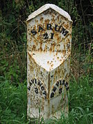
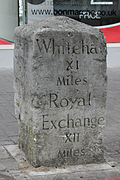
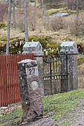
edit- United Kingdom
-

-

-

-
 Milestone on theA5130inBroughton, Milton Keynes
 -
 Milestone on the B3318 in Penwith,Cornwall
 -
-

-
 Milestone on B5500, in the township of Balterley,Staffordshire
 -
 Milestone on the B940 near Lathones inFife,Scotland
 -
 Milestone on Sutton High Street,Sutton, London
 -
 Milestone on Rod Moor Road,Dronfield,Derbyshire,UK


- Australia
-
 Milepost 18 fromBatemans Bay, New South Wales,now preserved in the town.35°42′05″S150°10′53″E/ 35.7014°S 150.1815°E

- Denmark
-


- Finland
-
-
 A milestone along theKing's RoadinSipoo
 -
 A milestone inJakobstad
 -
 A milestone inÄänekoski


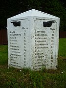
- India
-
 A milestone nearHaridwaron an Indian highway
 -


- Ireland
-
 A milestone atMilestoneinCounty Tipperary
 -

-
 Cast iron milestone onN71inCounty Cork
 -
 A milestone inMountbellew,County Galway


- United States
-
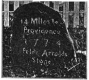
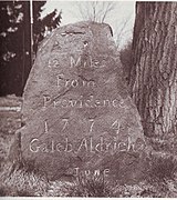 1774 Caleb Aldrich milestone onGreat RoadinRhode Island,United States
 -
-
 Milestone 8 on the UpperBoston Post RoadinHarvard Square,Massachusetts, United States
 -
 Milestone along the boundary of the original District of Columbiaset in 1792 and now marking the boundary betweenWashington, D.C.,andMarylandin theUnited States.
 -
 Historic granite milestone inKingston, Massachusetts,marking the42nd parallel.


- Post-Soviet countries
-
 Savyolovskoye directionof Moscow Railway

See also
edit- Boundary marker
- Exit number
- Ichirizuka
- Highway location marker
- Kilometre zero
- Milepost equation
- Parting stone
- Reassurance marker– a road sign with a route number, but no distance
- Survey marker
- Waymarking
References
edit- ^Collingwood, R. G.; Wright, R. P. (1965).The Roman Inscriptions of Britain. I: Inscriptions on stone.Oxford:Clarendon Press.
- ^"Milestones salvaged and added to the new museum's collection".Wirt Artna.Archived fromthe originalon 7 September 2014.Retrieved7 September2014.
- ^"'Monumental' treasure house ".The Times of India.12 July 2009. Archived fromthe originalon 11 August 2011.Retrieved23 September2013.
- ^"Kos Minar".University of Alberta. Archived fromthe originalon 4 March 2016.Retrieved12 September2018.
- ^Khandekar, Nivedita (27 October 2012)."A milestone on the highway".Hindustan Times.Archived fromthe originalon 23 September 2013.Retrieved23 September2013.
- ^Highways Agency."Driver Location Signs - Frequently Asked Questions".Archived fromthe originalon 10 August 2012.Retrieved10 February2010.
- ^"Poultney Family - Mort's Tree".5 September 2009.Retrieved13 April2012.
The kilometre marker near the tree - distance from Bulawayo [Photo caption]
- ^"94 Milestones".Railways Clauses Consolidation Act 1845.Retrieved3 November2008.
- ^"Section 26: Distance Markers".Railway Signs and Signals of Great Britain.Archived fromthe originalon 27 April 2021.Retrieved8 April2007.
External links
edit- "Brief History of American Milestone Markers".Stones of Northeastern United States.Retrieved24 August2014.
- Milestone in Ayrshire, Scotland
- The Milestone Society UK
- Mileposts and milestones on the Leeds Liverpool Canal
- milestones on the Thames & Severn Canal(and more than 41 other canals)
- map of milestones mid Gloucestershire UK(including old fingerposts)
- Article in Smith's Dictionary of Greek and Roman Antiquities with further links, including to a photograph of a Roman milestone in Orvieto
- Inventory of Roman milestones in France (in French)
- Section 2D.46of the U.S.Manual on Uniform Traffic Control Devices
- MileStonesGurus,a weblog pictures project with only milestones with an equal KM point