This articleneeds additional citations forverification.(June 2013) |
Nuwara Eliya(Sinhala:නුවර එළිය[nuwərəɛlijə];Tamil:நுவரெலியா[nʉʋəɾɛlɪjɑː]) is a city in the hill country of theCentral Province, Sri Lanka.Its name means "city on the plain (table land)" or "city of light". The city is the administrative capital ofNuwara Eliya District,with a picturesque landscape and temperate climate. It is at an altitude of 1,868 m (6,128 ft) and is considered to be the most important location fortea production in Sri Lanka.The city is overlooked byPidurutalagala,the tallest mountain in Sri Lanka. Nuwara Eliya is known for its temperate, cool climate – the coolest area in Sri Lanka.
Nuwara Eliya
| |
|---|---|
| Nuwara Eliya | |
 Nuwara Eliya skyline | |
| Nickname: Little England | |
 Nuwara Eliya Map of Sri Lanka showing the location of Nuwara Eliya | |
| Coordinates:6°58′0″N80°46′0″E/ 6.96667°N 80.76667°E | |
| Country | Sri Lanka |
| Province | Central Province |
| District | Nuwara Eliya District |
| Government | |
| • Type | Municipal Council |
| Area | |
| • Urban | 13 km2(5 sq mi) |
| Elevation | 1,868 m (6,129 ft) |
| Population (2011 census) | |
| •City | 27,500 |
| • Density | 3,197/km2(8,280/sq mi) |
| Time zone | UTC+5:30(Sri Lanka Standard Time Zone) |
| Postcode | 22200 |
| Area code | 052 |
History
The city was founded bySamuel Baker,the explorer ofLake Albertand the upperNilein 1846. Nuwara Eliya's climate lent itself to becoming the prime sanctuary of the British civil servants and planters in Ceylon. Nuwara Eliya, called Little England, was a hill country retreat where the British colonialists could immerse themselves in their pastimes such as fox hunting, deer hunting, elephant hunting, polo, golf and cricket.
Many of the buildings retain features from the colonial period such as theQueen's Cottage,General's House,Grand Hotel,Hill Club,St Andrew's HotelandTown Post Office.New hotels are often built and furnished in the colonial style. Visitors to the city can wallow in its nostalgia of bygone days by visiting the landmark buildings. Many private homes maintain their old English-style lawns and gardens.
-
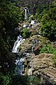 A waterfall in the surroundings of Nuwara Eliya
 -
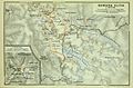 Map of Nuwara Eliya, ca 1914


Climate
Due to its highland location, Nuwara Eliya has asubtropical highland climate(Köppen climate classificationCfb),[1]having no pronounced dry season, amonsoon-like cloudy season and with a mean annual temperature of 16 °C (61 °F).
In the winter months, there can be frost at night, but it warms up rapidly during the day because of the high sun angle.
| Climate data for Nuwara Eliya, elevation 1,894 m (6,214 ft), (1991–2020, extremes 1869–present) | |||||||||||||
|---|---|---|---|---|---|---|---|---|---|---|---|---|---|
| Month | Jan | Feb | Mar | Apr | May | Jun | Jul | Aug | Sep | Oct | Nov | Dec | Year |
| Record high °C (°F) | 32.2 (90.0) |
31.7 (89.1) |
33.9 (93.0) |
29.9 (85.8) |
32.5 (90.5) |
27.6 (81.7) |
29.2 (84.6) |
29.8 (85.6) |
25.8 (78.4) |
27.6 (81.7) |
28.6 (83.5) |
27.5 (81.5) |
33.9 (93.0) |
| Mean daily maximum °C (°F) | 19.9 (67.8) |
21.0 (69.8) |
22.3 (72.1) |
22.5 (72.5) |
21.5 (70.7) |
19.2 (66.6) |
18.6 (65.5) |
19.0 (66.2) |
19.5 (67.1) |
19.7 (67.5) |
19.8 (67.6) |
19.4 (66.9) |
20.2 (68.4) |
| Daily mean °C (°F) | 15.1 (59.2) |
15.6 (60.1) |
16.6 (61.9) |
17.2 (63.0) |
17.4 (63.3) |
16.5 (61.7) |
16.1 (61.0) |
16.2 (61.2) |
16.3 (61.3) |
16.0 (60.8) |
16.1 (61.0) |
15.5 (59.9) |
16.2 (61.2) |
| Mean daily minimum °C (°F) | 10.4 (50.7) |
10.2 (50.4) |
10.8 (51.4) |
11.9 (53.4) |
13.4 (56.1) |
13.8 (56.8) |
13.5 (56.3) |
13.3 (55.9) |
12.9 (55.2) |
12.6 (54.7) |
12.3 (54.1) |
11.5 (52.7) |
12.2 (54.0) |
| Record low °C (°F) | −2.6 (27.3) |
−2.5 (27.5) |
−1.9 (28.6) |
0.8 (33.4) |
0.8 (33.4) |
6.4 (43.5) |
6.0 (42.8) |
5.1 (41.2) |
5.0 (41.0) |
1.2 (34.2) |
1.4 (34.5) |
−1.1 (30.0) |
−2.6 (27.3) |
| Averageprecipitationmm (inches) | 115.6 (4.55) |
72.7 (2.86) |
72.2 (2.84) |
133.5 (5.26) |
171.7 (6.76) |
168.3 (6.63) |
155.0 (6.10) |
132.4 (5.21) |
161.2 (6.35) |
246.6 (9.71) |
226.4 (8.91) |
182.9 (7.20) |
1,838.4 (72.38) |
| Average precipitation days(≥ 1.0 mm) | 9.5 | 6.7 | 7.1 | 12.6 | 13.4 | 15.1 | 16.0 | 13.9 | 14.5 | 18.9 | 17.6 | 14.9 | 160.2 |
| Averagerelative humidity(%) | 83 | 79 | 78 | 84 | 86 | 87 | 87 | 85 | 86 | 86 | 85 | 85 | 85 |
| Mean monthlysunshine hours | 167.4 | 163.9 | 198.4 | 156.0 | 102.3 | 84.0 | 68.2 | 74.4 | 87.0 | 117.8 | 123.0 | 142.6 | 1,485 |
| Percentpossible sunshine | 46 | 50 | 54 | 43 | 27 | 23 | 18 | 20 | 24 | 32 | 35 | 40 | 34 |
| Source 1:World Meteorological Organization[2] | |||||||||||||
| Source 2: DWD (humidity and sunshine 1931–1960)[3]Meteo Climat (extremes)[4] | |||||||||||||
Demographics
The majority of the population of Nuwara Eliya city isSinhalese.There are sizable communities belonging to other ethnic groups, such asIndian TamilsandSri Lankan Tamils.
| Ethnicity (2012) | Population |
|---|---|
| Sinhala | 19,157 (44.5%) |
| Sri Lankan Tamils | 9,557 (22.2%) |
| Indian Tamils | 9,101 (21.1%) |
| Sri Lankan Moors | 4,629 (10.8%) |
| Other (includingBurgher,Malay) | 606 (1.4%) |
| Total | 43,050 (100%) |
Source:statistics.gov.lk
Language
SinhalaandTamilare the two major languages spoken in Nuwara Eliya.Englishis also widely used by the locals.
Festivals

The town really comes alive in April for theSinhaleseandTamilNew Year.It is difficult to find accommodation as Sri Lankans holiday in the region during this period. The festive season starts on April 1 annually in a ceremonial manner. The ceremony consists mainly of a band show in which all the local school bands participate.
Main attractions during April include motor and horse racing events. Motor racing comes alive with the Mahagastotte and Radella Hill Climbs, the former being run since 1934. The Nuwara Eliya Road Race and the 4X4 Lake Cross on edge ofLake Gregoryattract a fair share of enthusiasts. Parties are held nightly in the hotels, and the season culminates in the nine-furlong (1811 m) Governor's Cup at theNuwara Eliya Racecourse,Golf Tournaments at theNuwara Eliya Golf Club,and the flower show at the end of the month.
Attractions

The town's attractions include the golf course, trout streams,Victoria Park,and boating or fishing onLake Gregory.Victoria Park is an attractive and well-used oasis. It is popular withbirdwatchersat quieter times because of the good opportunities for seeing species, particularly theIndian blue robin,pied thrushorscaly thrushlurking in the denser undergrowth. TheKashmir flycatcheris another attractivebirdspecies in the park.
Galway's Land Bird Sanctuary,close to Lake Gregory, is an area ofmontaneforest a few kilometers east of the town. Covering an area of 0.6 km2it is home to many bird and mammal speciesendemicto Sri Lanka, includingwild boarandbarking deer.
The city is a base for visits toHorton Plains National Park.This is a key wildlife area of an open grassy woodland. Species found here include theleopard,sambar,and the endemicpurple-faced langur.Endemic highland birds include thedull-blue flycatcher,Sri Lanka white-eye,andyellow-eared bulbul.The plains have a well-visited tourist attraction atWorld's End— a sheer precipice with a 1050 m drop. The return walk passes the scenicBaker's Falls.Early morning visits are best, both to see the wildlife and to view World's End before mists close in during the later part of the morning.
One of the distinctive features of Nuwara Eliya's countryside is the widespread growing of vegetables, fruit and flowers usually associated with temperate Europe. This "Little England" is covered with terraces growing potatoes, carrots, leeks, and roses interspersed withteabushes on the steeper slopes.
The slow-growing tea bushes of this highland region produce some of the world's finestorange pekoetea. Several tea factories around Nuwara Eliya offer guided tours and the opportunity to sample or purchase their products.
'Lovers Leap' is a spectacular waterfall set among tea plantations a short walk from the town of Nuwara Eliya. It falls a height of 30m in a long cascading sheet of water. It is said that it is named after a young couple who decided to be bound together forever by jumping off the cliff to their demise.[5]
Other places

A gravestone of Major Thomas William Rogers, (theGovernment AgentforBadulla District) is in the corner of the golf grounds. He is infamous for having shot, at the very lowest estimate 1,400 wildelephants.[6]Folklore in Nuwara Eliya says that every year his gravestone is struck by lightning for his great sin. This place is not open for visitors.
Another place related to folklore is the Hindu temple calledSeetha Kovil(Hanuman Kovil). It is found on the way to Badulla from Nuwara Eliya before reaching theHakgala Botanical Garden.The temple is in the village called Seetha Eliya. The area is related to theRamayanastory in Hinduism. Folklore says that the mighty kingRavanakidnapped princess Seeta who was the queen ofRamaand hid her where the temple now is.
There is a church called theHoly Trinity Churchon Church Road, which accommodates an old graveyard. Most of the gravestones have British names on them.
Transportation

The nearest train station is inNanu Oya,about 8 km away. Scheduled air taxi fromLake Gregory Waterdromelinks Nuwara Eliya toColombo.[7]
Sister cities
| Country | City | State / Region | Since |
|---|---|---|---|
| Yongzhou[8] | Hunan | 2009 | |
| Uji[9] | Kyoto | 1986 | |
| Vidnoye | Moscow Oblast |
See also
References
- ^"Climate: Nuwara Eliya CP (altitude: 1902m) - Climate graph, Temperature graph, Climate table".Climate-Data.org.Retrieved2013-12-12.
- ^"World Meteorological Organization Climate Normals for 1991–2020".World Meteorological Organization. Archived fromthe originalon 17 July 2021.Retrieved2 August2023.
- ^ "Klimatafel von Nuwara Eliya / Sri Lanka (Ceylon)"(PDF).Baseline climate means (1961-1990) from stations all over the world(in German).Deutscher Wetterdienst.RetrievedMay 9,2016.
- ^ "Station Nuwara Eliya"(in French). Meteo Climat.Retrieved26 August2021.
- ^"Nuwara Eliya".lonelyplanet.Lonely Planet.Retrieved11 May2017.
- ^Wright, Arnold (1907).Twentieth Century Impressions of Ceylon: Its History, People, Commerce, Industries, and Resources.London: Asian Educational Services, 1907. pp. 851–852.ISBN9788120613355.
- ^"Nuwara Eliya new air link to Colombo".Archived fromthe originalon 2017-12-29.Retrieved2011-04-16.
- ^Rajaratnam, P. (September 24, 2009),"Nuwara Eliya strengthens ties with Chinese Yongzhou city",Daily News,archived fromthe originalon 5 June 2011,retrieved6 September2010
- ^International Exchange: List of Sister Cities