Pawlettis a village and civil parish 4 miles (6 km) north ofBridgwater,in the English county ofSomerset.The parish includes the hamlet ofStretcholt.
| Pawlett | |
|---|---|
 Pawlett village shop | |
 Pawlett Location withinSomerset | |
| Population | 1,038 (2011)[1] |
| OS grid reference | ST300428 |
| Unitary authority | |
| Ceremonial county | |
| Region | |
| Country | England |
| Sovereign state | United Kingdom |
| Post town | BRIDGWATER |
| Postcode district | TA6 |
| Dialling code | 01278 |
| Police | Avon and Somerset |
| Fire | Devon and Somerset |
| Ambulance | South Western |
| UK Parliament | |
The village has Roman orSaxonorigins.[2]It has aNormanchurch and expanded in the 17th and 18th centuries with the draining of theSomerset Levels.
DuringWorld War IIit was the site of an experimental research station into anti-barrage balloonwarfare, where experiments were performed to examine ways to use cable cutting devices on the wings of aircraft to sever the cable on which the balloon was flown and thus allow the aircraft to continue on a mission unimpeded. Brave pilots flew their machines into cables to test the effectiveness of these cutters.
History
editA survey in 2003 recorded an early system of flood banks in the "Hams" around the village which may have originated in theRomanor Saxon periods. An early field system was also identified, again possibly originating in the Saxon period.[3]The Pawlett Hams form part of theBridgwater BaySite of Special Scientific Interest.
A small settlement of six households was recorded asPaveletin the 1086Domesday Book.[4]In the 12th century the Pawlett Hams, running west of the village, were known as being the richest 2,000 acres (8 km2) in England.[5]
The name of the village is believed to come from an 11th-century estate and may refer to a stream, either with stakes or below a steep-sided hill.[citation needed]
The village lies on a bend of theRiver Parrettnear to its mouth and had a landing place, called Pawlett pill, by the 15th century. It continued in use in the 18th century, but by 1780 it had been blocked by Canham sluice as part of the drainage of theSomerset Levels.[6]In the 19th century Pawlett had a jury of sewers to view rhynes and ditches, and by 1936 the parish had its own water board to supervise drainage and freshwater irrigation of the Hams. This was absorbed into the Bridgwater and Pawlett drainage board in 1946.[7]
In 1801 the population was 429, rising to 433 in 1811 and to 529 in 1821 when there were only 69 houses for 98 families. Numbers peaked at 597 in 1871, but fell from 483 in 1891 and to 346 in 1901. The population thereafter increased to 374 in 1911, 462 in 1931, 672 in 1961, and 786 in 1981.
A village school, supported byAnthony Ashley-Cooper, 1st Earl of Shaftesbury,was established in the late 18th century. Shaftesbury held the subsidiary title of 2nd Baron of Pawlett. In 1861, a National School was established near the church. A school board for the parish was elected in 1887 and built a school on the National School site in 1888. In 1903 there were 58 children on the register and despite some fluctuations during the intervening years there were 53 children aged 5 to 11 on the books in 1975 and 75 in 1981. A new County School opened west of the village in 1977 to replace the old building.[8]
During theSecond World Wardefences were constructed around Pawlett as a part ofBritish anti-invasion preparations of World War II;nearby Pawlett Hill was adefended localityon theTaunton Stop Line,where the defences mainly comprise a number ofpillboxes.There was also a RAF station used for carrying out experiments relating to barrage balloons.[9]The hangar measures 100 feet (30 m) x 70 feet (21 m) x 80 feet (24 m) high and was erected in 1940–41 The hangar was needed so that the balloon being tested need not be deflated each night. The balloon was filled with a mixture of air andhydrogenmade at theWeston-super-Maregasworks. The experimental work continued until 1944.[10]ABristol Blenheimbomber crashed in the village during the war and the remains were excavated in 2007.[11]
Governance
editTheparish councilhas responsibility for local issues, including setting an annual precept (local rate) to cover the council’s operating costs and producing annual accounts for public scrutiny. The parish council evaluates local planning applications and works with the local police, district council officers, andneighbourhood watchgroups on matters of crime, security, and traffic. The parish council's role also includes initiating projects for the maintenance and repair of parish facilities, as well as consulting with the district council on the maintenance, repair, and improvement of highways, drainage, footpaths, public transport, and street cleaning. Conservation matters (including trees and listed buildings) and environmental issues are also the responsibility of the council.
Forlocal governmentpurposes, since 1 April 2023, the village comes under theunitary authorityofSomerset Council.Prior to this, it was part of thenon-metropolitan districtofSedgemoor,which was formed on 1 April 1974 under theLocal Government Act 1972,having previously been part ofBridgwater Rural District.[12]
It is also part of theBridgwatercounty constituencyrepresented in theHouse of Commonsof theParliament of the United Kingdom.It elects oneMember of Parliament (MP)by thefirst past the postsystem of election.
Church
editTheNormanChurch of John the Baptistreplaced an earlierSaxonstructure and the church is thought to have been a popular station on medieval pilgrimages fromWatchettoGlastonbury.The south doorway arch features three bands of decoration: lozenges, zigzags, and a biting beasts motif on the outer ring. Thebaptismal fontappears to be made from two separate fonts, the bottom part an inverted Saxon font topped with an upright plain Norman font.
The rood screen is 15th-century. The 20th-century north window showsChristblessing children who are in modern dress and holding a teddy bear and toy boat.[13]Other unusual features include pew boxes that retain hat pegs, reflecting a time when congregants wore hats to church. The chancel includes wide communion rails on three sides, thought to have been used for seated communion. Unusual and ancient features of the church in part owe their preservation to major renovations made in 1779. That "modernization" seems to have slaked the zeal for Victorian-era updates which eliminated such features in many other churches in the area. Crumbling of the church'sblue liasstone led to its exterior being coated with cement. It has been designated byEnglish Heritageas a Grade Ilisted building.[14]
Notable people
editPeter HaggettCBE ScD FBA (b. 1933), academic geographer, emeritus professor atUniversity of Bristol,was born in Pawlett.[15]
Gallery
edit-
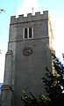 Bell tower of St John the Baptist church, Pawlett
 -
 South side of St John the Baptist church
 -
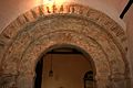 Norman arch over south door, St John the Baptist church
 -
 Inverted Saxon baptismal font supporting upright Norman font
 -
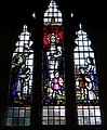 North window stained glass with modern-era children memorializes Rose Helena Wadden, said to have taught the first children's Sunday School class in Bridgwater
 -
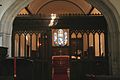 Rood screen and altar
 -
 Pew boxes still include pegs for hanging up hats


References
edit- ^"Statistics for Wards, LSOAs and Parishes — SUMMARY Profiles"(Excel).Somerset Intelligence.Retrieved4 January2014.
- ^Havinden, Michael.The Somerset Landscape.The making of the English landscape. London: Hodder and Stoughton. p. 74.ISBN0-340-20116-9.
- ^"Desk top and walk over survey (2003) Pawlett Hams, Pawlett".Somerset Historic Environment Record.Retrieved26 September2007.
- ^Pawlettin theDomesday Book
- ^"Pictures of Pawlett".Pictures of England.Retrieved26 September2007.
- ^"Pawlett".British History Online.Retrieved26 September2007.
- ^"Pawlett local government".British History Online.Retrieved26 September2007.
- ^"Pawlett Education".British History Online.Retrieved26 September2007.
- ^Foot, William (2006).Beaches, fields, streets, and hills... the anti-invasion landscapes of England, 1940 (pp 257-264).Council for British Archaeology.ISBN1-902771-53-2.
- ^"Balloon hangar, west of Pawlett Hill, Pawlett".Somerset Historic Environment Record.Retrieved26 September2007."Military research establishment, Pawlett".Somerset Historic Environment Record.Retrieved26 September2007.
- ^"WWII bomber found in county field".BBC News.2 August 2007.Retrieved26 September2007.
- ^"Bridgwater RD".A vision of Britain Through Time.University of Portsmouth.Retrieved4 January2014.
- ^"St John the Baptist Church".UK attractions.Archived fromthe originalon 28 October 2007.Retrieved26 September2007.
- ^Historic England."Church of St John the Baptist (1173441)".National Heritage List for England.Retrieved26 September2007.
- ^"UWE awards honorary degree to Professor Peter Haggett"(Press release).UWE-Bristol Press Office.24 November 2004.Retrieved29 May2008.