This articleneeds additional citations forverification.(October 2011) |
TheA5127is a majorroadinEnglandwhich runs betweenBirminghamandLichfield,Staffordshire.For much of the route the road follows the old route of theA38which has since been moved in order to by-pass places such asErdingtonandSutton Coldfieldand form arelief roadfrom Birmingham city centre toSpaghetti Junction.
| A5127 | ||||
|---|---|---|---|---|
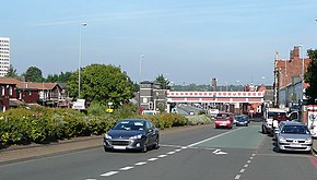
 The A5127, Lichfield Road inAston | ||||
| Location | ||||
| Country | United Kingdom | |||
| Constituent country | England | |||
| Road network | ||||
| ||||
The part from the county boundary, throughShenstoneto Lichfield was one of the roads of theLichfield Turnpike Trust,established in 1729.[1]Beyond Lichfield, it joins the RomanRyknild StreetatStreethay[2]and immediately after that joins the present A38.
Route
editThis article contains a bulleted list or table of intersections whichshould be presented in a properly formatted junction table.(December 2021) |
Main places and junctions[3]along the A5127:
- Birmingham
- Aston,Birmingham
- A38(M)Aston ExpresswayJunction (52°29′32″N1°53′19″W/ 52.49234°N 1.88857°W)
- M6 motorwayJunction 6 (Gravelly Hill Interchange / Spaghetti Junction;52°30′34″N1°51′34″W/ 52.50941°N 1.85938°W)
- Gravelly Hill,Birmingham
- Erdington,Birmingham (52°31′28″N1°50′26″W/ 52.52457°N 1.84049°W)
- A452Chester Road junction (52°32′00″N1°49′45″W/ 52.53345°N 1.82903°W)
- Wylde Green,Birmingham
- Sutton Coldfield,Birmingham (52°33′54″N1°49′20″W/ 52.56507°N 1.82236°W)
- Passes nearSutton Park
- A453Tamworth Road junction (52°34′16″N1°49′23″W/ 52.57107°N 1.82308°W)
- A454junction (52°34′44″N1°49′46″W/ 52.57893°N 1.82947°W)
- Four Oaks, Birmingham
- Birmingham & West Midlands/ Staffordshire boundary (52°36′25″N1°50′17″W/ 52.60696°N 1.83815°W)
- Shenstone,Staffordshire
- Walljunction withM6 Toll(52°38′44″N1°50′04″W/ 52.64555°N 1.83432°W),A5andA5148(leading toA38)
- A461/A51Junction (52°40′34″N1°49′53″W/ 52.67609°N 1.83145°W)
- Lichfield,Staffordshire
- A38 Junction (52°41′34″N1°47′17″W/ 52.69270°N 1.78813°W)
This route closely follows theCross-City Line.
References
edit- ^Lichfield Roads Act 1728(2 Geo. 2.c. 5)
- ^Margary, Ivan (1967). Roman Roads in Britain. John Baker Publishers., pp. 305–6.
- ^coordinates fromOpenStreetMap
52°35′20″N1°49′53″W/ 52.5890°N 1.8313°W
