Borden(2021 population:312) is avillagein theCanadian provinceofSaskatchewanwithin theRural Municipality of Great Bend No. 405andCensus Division No. 16.Borden is named afterSir Frederick William Borden,Minister of Militia in the Laurier Cabinet.[5]An abandoned arch bridge with the same name (Borden Bridge) is located to the southeast and was once used to carryHighway 16across theNorth Saskatchewan River.
Borden | |
|---|---|
| Village of Borden | |
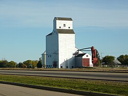
 Grain elevatorin Borden. | |
| Coordinates:52°24′47″N107°13′19″W/ 52.413°N 107.222°W | |
| Country | Canada |
| Province | Saskatchewan |
| Region | Saskatchewan |
| Census division | 16 |
| Rural Municipality | Great Bend |
| Post office Founded | 1905 |
| Incorporated(Village) | 1907 |
| Fire Dept. | 1941 |
| Government | |
| • Type | Municipal |
| • Governing body | Borden Village Council |
| •Mayor | Jamie Brandrick |
| •Administrator | Carly Hess |
| Area | |
• Total | 0.76 km2(0.29 sq mi) |
| Population (2021) | |
• Total | 312 |
| • Density | 378.5/km2(980/sq mi) |
| Time zone | UTC-6(CST) |
| Postal code | S0K 0N0 |
| Area code | 306 |
| Highways | Highway 685 |
| Railways | Canadian National Railway |
| Website | Village of Borden |
| [1][2][3][4] | |
History
editBorden incorporated as a village on July 19, 1907.[6]
Demographics
editIn the2021 Census of Populationconducted byStatistics Canada,Borden had a population of312living in120of its131total private dwellings, a change of-2.1% from its 2016 population of287.With a land area of 0.73 km2(0.28 sq mi), it had a population density of384.9/km2(997.0/sq mi) in 2021.[9]
In the2016 Census of Population,the Village of Borden recorded a population of287living in126of its140total private dwellings, a14.6% change from its 2011 population of245.With a land area of 0.76 km2(0.29 sq mi), it had a population density of377.6/km2(978.1/sq mi) in 2016.[10]
Notable people
edit- David Buckingham,politician.
- Savannah Sutherland,is a 400 m Olympic hurdler.
See also
editReferences
edit- ^National Archives, Archivia Net,Post Offices and Postmasters,archived fromthe originalon 2006-10-06
- ^Government of Saskatchewan, MRD Home,Municipal Directory System,archived fromthe originalon November 21, 2008
- ^Canadian Textiles Institute. (2005),CTI Determine your provincial constituency,archived fromthe originalon 2007-09-11
- ^Commissioner of Canada Elections, Chief Electoral Officer of Canada (2005),Elections Canada On-line,archived fromthe originalon 2007-04-21
- ^"Geographic Names of Saskatchewan", Bill Barry (2005), p 53.
- ^"Urban Municipality Incorporations".Saskatchewan Ministry of Government Relations. Archived fromthe originalon October 15, 2014.RetrievedJune 1,2020.
- ^"Saskatchewan Census Population"(PDF).Saskatchewan Bureau of Statistics. Archived fromthe original(PDF)on September 24, 2015.RetrievedMay 31,2020.
- ^"Saskatchewan Census Population".Saskatchewan Bureau of Statistics.RetrievedMay 31,2020.
- ^"Population and dwelling counts: Canada, provinces and territories, census divisions and census subdivisions (municipalities), Saskatchewan".Statistics Canada.February 9, 2022.RetrievedApril 1,2022.
- ^"Population and dwelling counts, for Canada, provinces and territories, and census subdivisions (municipalities), 2016 and 2011 censuses – 100% data (Saskatchewan)".Statistics Canada.February 8, 2017.RetrievedMay 30,2020.

