Aduneis alandformcomposed of wind- or water-drivensand.It typically takes the form of a mound, ridge, or hill.[1]An area with dunes is called adune system[2][3][4][5]or adune complex.[6]A large dune complex is called adune field,[7]while broad, flat regions covered with wind-swept sand or dunes, with little or no vegetation, are calledergsorsand seas.[8][9][10]Dunes occur in different shapes and sizes, but most kinds of dunes are longer on thestoss(upflow) side, where the sand is pushed up the dune, and have a shorterslip facein the lee side.[11]The valley or trough between dunes is called adune slack.[12]
Dunes are most common in desert environments, where the lack of moisture hinders the growth of vegetation that would otherwise interfere with the development of dunes. However, sand deposits are not restricted to deserts, and dunes are also found along sea shores, along streams in semiarid climates, in areas ofglacial outwash,and in other areas where poorly cementedsandstonebedrock disintegrates to produce an ample supply of loose sand.[13]Subaqueous dunes can form from the action of water flow (fluvialprocesses) on sand orgravelbeds ofrivers,estuaries,and the sea-bed.[14][15]
Some coastal areas have one or more sets of dunes running parallel to the shoreline directly inland from thebeach.In most cases, the dunes are important in protecting the land against potential ravages by storm waves from thesea.[16]Artificial dunes are sometimes constructed to protect coastal areas.[17][18]The dynamic action of wind and water can sometimes cause dunes to drift, which can have serious consequences. For example, the town ofEucla, Western Australia,had to be relocated in the 1890s because of dune drift.[19]
The modern word "dune" came into English from French around 1790,[20]which in turn came fromMiddle Dutchdūne.[14]
Sand hitting sand is more likely to stick; sand hitting a more coherent surface is more likely to bounce (saltation). This exacerbatingfeedback loophelps sand accumulate into dunes.
A universally precise distinction does not exist between ripples, dunes, anddraas,[21]which are all deposits of the same type of materials. Dunes are generally defined as greater than 7 cm tall and may have ripples, while ripples are deposits that are less than 3 cm tall.[22]A draa is a very large aeolian landform, with a length of several kilometers and a height of tens to hundreds of meters, and which may have superimposed dunes.[23]
Dunes are made of sand-sized particles, and may consist of quartz, calcium carbonate, snow, gypsum, or other materials. The upwind/upstream/upcurrent side of the dune is called the stoss side; the downflow side is called the lee side. Sand is pushed (creep) or bounces (saltation) up the stoss side, and slides down the lee side. A side of a dune that the sand has slid down is called aslip face(or slipface).
TheBagnold formulagives the speed at which particles can be transported.
Five basic dune types are recognized: crescentic, linear, star, dome, and parabolic. Dune areas may occur in three forms: simple (isolated dunes of basic type), compound (larger dunes on which smaller dunes of same type form), and complex (combinations of different types).[24]
Isolated barchan dunes on the surface ofMars.Dominant wind direction would be from left to right.
Barchan dunes are crescent-shaped mounds which are generally wider than they are long. The lee-side slipfaces are on the concave sides of the dunes. These dunes form under winds that blow consistently from one direction (unimodal
winds). They form separate crescents when the sand supply is comparatively small. When the sand supply is greater, they may merge into barchanoid ridges, and then transverse dunes (see below).
Some types of crescentic dunes move more quickly overdesertsurfaces than any other type of dune. A group of dunes moved more than 100 metres per year between 1954 and 1959 inChina'sNingxia Province,and similar speeds have been recorded in theWestern DesertofEgypt.The largest crescentic dunes on Earth, with mean crest-to-crest widths of more than three kilometres, are in China'sTaklamakan Desert.[24]
Abundant barchan dunes may merge into barchanoid ridges, which then grade into linear (or slightly sinuous) transverse dunes, so called because they lie transverse, or across, the wind direction, with the wind blowing perpendicular to the ridge crest.[25]
Seif dunes are linear (or slightly sinuous) dunes with two slip faces.[25]The two slip faces make them sharp-crested. They are calledseifdunes after the Arabic word for "sword". They may be more than 160 kilometres (100 miles) long, and thus easily visible in satellite images (see illustrations).
Seif dunes are associated with bidirectional winds. The long axes and ridges of these dunes extend along the resultant direction of sand movement (hence the name "longitudinal" ).[26]Some linear dunes merge to form Y-shaped compound dunes.[24]
Formation is debated.Ralph Bagnold,inThe Physics of Blown Sand and Desert Dunes,suggested that some seif dunes form when a barchan dune moves into a bidirectional wind regime, and one arm or wing of the crescent elongates. Others suggest that seif dunes are formed byvorticesin a unidirectional wind.[25]In the sheltered troughs between highly developed seif dunes, barchans may be formed, because the wind is constrained to be unidirectional by the dunes.
Rub' al Khali (Arabian Empty Quarter) sand dunes imaged by Terra (EOS AM-1). Most of these dunes are seif dunes. Their origin from barchans is suggested by the stubby remnant "hooks" seen on many of the dunes. Wind would be from left to right.
The average-direction-longitudinal model of seif dune formation
By contrast, transverse dunes form with the wind blowing perpendicular to the ridges, and have only one slipface, on the lee side. The stoss side is less steep.
Transverse dunes lie perpendicular to the wind, which moves them forwards, producing thecross-beddingshown here.
Seif dunes are common in the Sahara. They range up to 300 m (980 ft) in height and 300 km (190 mi) in length. In the southern third of the Arabian Peninsula, a vasterg,called theRub' al Khalior Empty Quarter, contains seif dunes that stretch for almost 200 km (120 mi) and reach heights of over 300 m (980 ft).
Linearloesshills known aspahasare superficially similar. These hills appear to have been formed during the lastice ageunderpermafrostconditions dominated by sparsetundravegetation.
Star dunes are pyramidal sand mounds with slipfaces on three or more arms that radiate from the high center of the mound. They tend to accumulate in areas with multidirectional wind regimes. Star dunes grow upward rather than laterally. They dominate theGrand Erg Orientalof the Sahara. In other deserts, they occur around the margins of thesand seas,particularly near topographic barriers. In the southeastBadain Jaran Desertof China, the star dunes are up to 500 metres tall and may be the tallest dunes on Earth.
Fixed crescentic dunes that form on the leeward margins ofplayasand river valleys in arid and semiarid regions in response to the direction (s) of prevailing winds, are known as lunettes, source-bordering dunes, bourrelets and clay dunes. They may be composed of clay, silt, sand, or gypsum, eroded from the basin floor or shore, transported up the concave side of the dune, and deposited on the convex side. Examples in Australia are up to 6.5 km long, 1 km wide, and up to 50 metres high. They also occur insouthernandWest Africa,and in parts of the western United States, especially Texas.[27]
U-shaped mounds of sand with convex noses trailed by elongated arms are parabolic dunes. These dunes are formed from blowout dunes where the erosion of vegetated sand leads to a U-shaped depression. The elongated arms are held in place by vegetation; the largest arm known on Earth reaches 12 km. Sometimes these dunes are called U-shaped,blowout,or hairpin dunes, and they are well known in coastal deserts. Unlike crescent shaped dunes, their crests point upwind. The bulk of the sand in the dune migrates forward.
In plan view, these are U-shaped or V-shaped mounds of well-sorted, very fine to medium sand with elongated arms that extend upwind behind the central part of the dune. There are slipfaces that often occur on the outer side of the nose and on the outer slopes of the arms.
These dunes often occur in semiarid areas where the precipitation is retained in the lower parts of the dune and underlyingsoils.The stability of the dunes was once attributed to the vegetative cover but recent research has pointed to water as the main source of parabolic dune stability. The vegetation that covers them—grasses, shrubs, and trees—help anchor the trailing arms. In inland deserts, parabolic dunes commonly originate and extend downwind from blowouts in sand sheets only partly anchored by vegetation. They can also originate from beach sands and extend inland into vegetated areas in coastal zones and on shores of large lakes.
Most parabolic dunes do not reach heights higher than a few tens of metres except at their nose, where vegetation stops or slows the advance of accumulating sand.
Simple parabolic dunes have only one set of arms that trail upwind, behind the leading nose. Compound parabolic dunes are coalesced features with several sets of trailing arms. Complex parabolic dunes include subsidiary superposed or coalesced forms, usually of barchanoid or linear shapes.
Parabolic dunes, like crescent dunes, occur in areas where very strong winds are mostly unidirectional. Although these dunes are found in areas now characterized by variable wind speeds, the effective winds associated with the growth and migration of both the parabolic and crescent dunes probably are the most consistent in wind direction.
The grain size for these well-sorted, very fine to medium sands is about 0.06 to 0.5 mm. Parabolic dunes have loose sand and steep slopes only on their outer flanks. The inner slopes are mostly well packed and anchored by vegetation, as are the corridors between individual dunes. Because all dune arms are oriented in the same direction, and, the inter-dune corridors are generally swept clear of loose sand, the corridors can usually be traversed in between the trailing arms of the dune. However to cross straight over the dune by going over the trailing arms, can be very difficult. Also, traversing the nose is very difficult as well because the nose is usually made up of loose sand without much if any vegetation.
A type of extensive parabolic dune that lacks discernible slipfaces and has mostly coarse grained sand is known as azibar.[28]The term zibar comes from theArabicword to describe "rolling transverse ridges... with a hard surface".[29]The dunes are small, have low relief, and can be found in many places across the planet fromWyoming(United States) to Saudi Arabia to Australia.[30]Spacing between zibars ranges from 50 to 400 metres and they do not become more than 10 metres high.[31]The dunes form at about ninety degrees to the prevailing wind which blows away the small, fine-grained sand leaving behind the coarser grained sand to form the crest.[32]
Reversing dune showing short minor slipface atop the major stoss (upwind) face
Occurring wherever winds periodically reverse direction, reversing dunes are varieties of any of the above shapes. These dunes typically have major and minor slipfaces oriented in opposite directions. The minor slipfaces are usually temporary, as they appear after a reverse wind and are generally destroyed when the wind next blows in the dominant direction.[25]
Dune Nine inSossusvlei,Namibia, is over 300m high.
Draas are very large-scale dune bedforms; they may be tens or a few hundreds of metres in height, kilometres wide, and hundreds of kilometres in length.[25]After a draa has reached a certain size, it generally develops superimposed dune forms.[33]They are thought to be more ancient and slower-moving than smaller dunes,[25]and to form by vertical growth of existing dunes. Draas are widespread in sand seas and arewell-represented in the geological record.[33]
All these dune shapes may occur in three forms: simple (isolated dunes of basic type), compound (larger dunes on which smaller dunes of same type form), and complex (combinations of different types).[24]Simple dunes are basic forms with the minimum number of slipfaces that define the geometric type. Compound dunes are large dunes on which smaller dunes of similar type and slipface orientation are superimposed. Complex dunes are combinations of two or more dune types. A crescentic dune with a star dune superimposed on its crest is the most common complex dune. Simple dunes represent a wind regime that has not changed in intensity or direction since the formation of the dune, while compound and complex dunes suggest that the intensity and direction of the wind has changed.
The sand mass of dunes can move either windward or leeward, depending on if the wind is making contact with the dune from below or above its apogee. If wind hits from above, the sand particles move leeward; the leeward flux of sand is greater than the windward flux. Conversely, if sand hits from below, sand particles move windward. Further, if the wind is carrying sand particles when it hits the dune, the dune's sand particles will saltate more than if the wind had hit the dune without carrying sand particles.[34]
Coastal dunes covered in grasses around the mouth of the Liver Å river in DenmarkNewborough Dune Rejuvenation, Wales; video of work done byNatural Resources Wales;2015
Coastal dunes[35]form when wet sand is deposited along the coast and dries out and is blown along the beach.[36]Dunes form where the beach is wide enough to allow for the accumulation of wind-blown sand, and where prevailingonshore windstend to blow sand inland. The three key ingredients for coastal dune formation are a large sand supply, winds to move said sand supply, and a place for the sand supply to accumulate.[37]Obstacles—for example, vegetation, pebbles and so on—tend to slow down the wind and lead to the deposition of sand grains.[38]These small "incipient dunes or" shadow dunes "tend to grow in the vertical direction if the obstacle slowing the wind can also grow vertically (i.e., vegetation). Coastal dunes expand laterally as a result of lateral growth of coastal plants via seed orrhizome.[39][40]Models of coastal dunes suggest that their final equilibrium height is related to the distance between the water line and where vegetation can grow.[41]Coastal dunes can be classified by where they develop, or begin to take shape. Dunes are commonly grouped into either the Primary Dune Group or the Secondary Dune Group.[35]Primary dunes gain most of their sand from the beach itself, while secondary dunes gain their sand from the primary dune. Along the Florida Panhandle, most dunes are considered to be foredunes or hummocks.[42][43]Different locations around the globe have dune formations unique to their given coastal profile.
Coastal sand dunes can provide privacy and/or habitats to support local flora and fauna. Animals such as sand snakes, lizards, and rodents can live in coastal sand dunes, along with insects of all types.[44]Often the vegetation of sand dunes is discussed without acknowledging the importance that coastal dunes have for animals. Further, some animals, such as foxes and feral pigs can use coastal dunes as hunting grounds to find food.[45]Birds are also known to utilize coastal dunes as nesting grounds. All these species find the coastal environment of the sand dune vital to their species' survival.
Over the course of time coastal dunes may be impacted bytropical cyclonesor other intense storm activity, dependent on their location. Recent work has suggested that coastal dunes tend to evolve toward a high or low morphology depending on the growth rate of dunes relative to storm frequency.[46][47]During a storm event, dunes play a significant role in minimizing wave energy as it moves onshore. As a result, coastal dunes, especially those in the foredune area affected by astorm surge,will retreat or erode.[48]To counteract the damage from tropical activity on coastal dunes, short term post-storm efforts can be made by individual agencies through fencing to help with sand accumulation.[49]
How much a dune erodes during any storm surge is related to its location on the coastal shoreline and the profile of the beach during a particular season. In those areas with harsher winter weather, during the summer a beach tends to take on more of a convex appearance due to gentler waves, while the same beach in the winter may take on more of a concave appearance. As a result, coastal dunes can get eroded much more quickly in the winter than in the summer. The converse is true in areas with harsher summer weather.[50]
There are many threats to these coastal communities. Some coastal dunes, for example ones in San Francisco, have been completely altered by urbanization; reshaping the dune for human use. This puts native species at risk. Another danger, in California and places in the UK specifically, is the introduction of invasive species. Plant species, such asCarpobrotus edulis,were introduced from South Africa in an attempt to stabilize the dunes and provide horticultural benefits, but instead spread taking land away from native species.Ammophila arenaria,known as European beachgrass, has a similar story, though it has no horticulture benefits. It has great ground coverage and, as intended, stabilized the dunes but as an unintended side effect prevented native species from thriving in those dunes. One such example is the dune field atPoint Reyes, California.There are now efforts to get rid of both of these invasive species.[51][52]
As a dune forms, plantsuccessionoccurs. The conditions on anembryo duneare harsh, withsalt sprayfrom the sea carried on strong winds. The dune is well drained and often dry, and composed of calcium carbonate from seashells. Rottingseaweed,brought in by storm waves adds nutrients to allowpioneer speciesto colonize the dune. For example, in theUnited Kingdomthese pioneer species are oftenmarram grass,sea wort grassand other sea grasses. These plants are well adapted to the harsh conditions of the foredune, typically having deep roots which reach thewater table,root nodulesthat producenitrogencompounds, and protectedstoma,reducingtranspiration.Also, the deep roots bind the sand together, and the dune grows into aforeduneas more sand is blown over the grasses. The grasses addnitrogento the soil, meaning other, less hardy plants can then colonize the dunes. Typically these areheather,heathsandgorses.These too are adapted to the lowsoil watercontent and have small, prickly leaves which reduce transpiration. Heather addshumusto the soil and is usually replaced byconiferoustrees, which can tolerate lowsoil pH,caused by the accumulation and decomposition of organic matter with nitrate leaching.[53]Coniferous forests andheathlandare commonclimax communitiesfor sand dune systems.
Young dunes are calledyellow dunesand dunes which have high humus content are calledgrey dunes.Leaching occurs on the dunes, washing humus into the slacks, and the slacks may be much more developed than the exposed tops of the dunes. It is usually in the slacks that more rare species are developed and there is a tendency for the dune slacks' soil to be waterlogged where only marsh plants can survive. In Europe these plants include: creeping willow, cotton grass,yellow iris,reeds, and rushes. As for vertebrates in European dunes,natterjack toadssometimes breed here.
Dune ecosystems are extremely difficult places for plants to survive. This is due to a number of pressures related to their proximity to the ocean and confinement to growth on sandy substrates. These include:
In deserts where large amounts of limestone mountains surround aclosed basin,such as atWhite Sands National Parkin south-centralNew Mexico,occasional storm runoff transports dissolved limestone andgypsuminto a low-lying pan within the basin where the water evaporates, depositing the gypsum and forming crystals known asselenite.The crystals left behind by this process are eroded by the wind and deposited as vast white dune fields that resemble snow-covered landscapes. These types of dune are rare, and only form in closed arid basins that retain the highly soluble gypsum that would otherwise be washed into the sea.[54]
Anabkha,or coppice dune, is a small dune anchored by vegetation. They usually indicate desertification or soil erosion, and serve as nesting and burrow sites for animals.
Sub-aqueous (underwater) dunes form on a bed of sand or gravel under the actions of water flow. They are ubiquitous in naturalchannelssuch as rivers and estuaries, and also form in engineeredcanalsand pipelines.[55][56][57]Dunes move downstream as the upstream slope is eroded and the sediment deposited on the downstream or lee slope in typicalbedformconstruction.[58]In the case of sub-aqueous barchan dunes, sediment is lost by their extremities, known as horns.[59][60]
These dunes most often form as a continuous 'train' of dunes, showing remarkable similarity inwavelengthand height. The shape of a dune gives information about its formation environment.[61]For instance, rivers produce asymmetrical ripples, with the steeper slip face facing downstream. Ripple marks preserved in sedimentary strata in the geological record can be used to determine the direction of current flow, and thus an indication of the source of the sediments.
Dunes on the bed of a channel significantly increase flow resistance, their presence and growth playing a major part in riverflooding.
Cross-bedding in lithified aeolian sand dunes preserved as sandstone in Zion National Park, Utah
Alithified(consolidated) sand dune is a type ofsandstonethat is formed when a marine or aeolian sand dune becomes compacted and hardened. Once in this form, water passing through the rock can carry and deposit minerals, which can alter the colour of the rock.Cross-beddedlayers of stacks of lithified dunes can produce the cross-hatching patterns, such as those seen inZion National Parkin the western United States.
A slang term, used in thesouthwest US,for consolidated and hardened sand dunes is "slickrock", a name that was introduced by pioneers of theOld Westbecause their steel-rimmed wagon wheels could not gain traction on the rock.[citation needed]
Sand dunes can have a negative impact on humans when they encroach on human habitats. Sand dunes move via a few different means, all of them helped along by wind. One way that dunes can move is bysaltation,where sand particles skip along the ground like abouncing ball.When these skipping particles land, they may knock into other particles and cause them to move as well, in a process known ascreep.With slightly stronger winds, particles collide in mid-air, causingsheet flows.In a majordust storm,dunes may move tens of metres through such sheet flows. Also as in the case of snow, sandavalanches,falling down theslipfaceof the dunes—that face away from the winds—also move the dunes forward.
Sand threatens buildings and crops in Africa, the Middle East, and China. Drenching sand dunes with oil stops their migration, but this approach uses a valuable resource and is quite destructive to the dunes' animal habitats.Sand fencesmight also slow their movement to a crawl, but geologists are still analyzing results for the optimum fence designs.[62]Preventing sand dunes from overwhelming towns, villages, and agricultural areas has become a priority for theUnited Nations Environment Programme.Planting dunes with vegetation also helps to stabilise them.
Dune habitats provide niches for highly specialized plants and animals, including numerousrare speciesand someendangered species.Due to widespread human population expansion, dunes face destruction through land development and recreational usages, as well as alteration to prevent the encroachment of sand onto inhabited areas. Some countries, notably the United States, Australia, Canada, New Zealand, the United Kingdom, Netherlands, and Sri Lanka have developed significant programs of dune protection through the use ofsand dune stabilization.In the U.K., aBiodiversity Action Planhas been developed to assess dunes loss and to prevent future dunes destruction.
Victoria Island Sand Dunes,160 km North West of Cambridge Bay, Nunavut, Canada. Approximately 600 square kilometers, the largest in Canada, third largest in North America and the largest in the Arctic. There are two lakes with direct access to the Dunes from float planes.
Dunes can likely be found in any environment where there is a substantial atmosphere, winds, and dust to be blown. Dunes are common onMarsand in the equatorial regions ofTitan.
Titan's dunes include large expanses with modal lengths of about 20–30 km. The regions are not topographically confined, resembling sand seas. These dunes are interpreted to be longitudinal dunes whose crests are oriented parallel to the dominant wind direction, which generally indicates west-to-east wind flow. The sand is likely composed of hydrocarbon particles, possibly with some water ice mixed in.[76]
^abcdefMangimeli, John (10 September 2007)."Geology of Sand Dunes".U.S.A. National Park Service.Retrieved15 January2021.
^Radebaugh, Jani; Sharma, Priyanka; Korteniemi, Jarmo; Fitzsimmons, Kathryn E. (2014). "Longitudinal Dunes (or Linear Dunes)".Encyclopedia of Planetary Landforms.pp. 1–11.doi:10.1007/978-1-4614-9213-9_460-2.ISBN978-1-4614-9213-9.
^Twidale, C.R.& Campbell, E.M. (2005, revised edition): Australian landforms: understanding a low, flat, arid and old landscape. Rosenberg Publishing. pp. 241–3.ISBN1 877058 32 7
^Goudie, Ron Cooke; Andrew Warren; Andrew (1996).Desert geomorphology(2. impr. ed.). London: UCL Press. pp. 395–396.ISBN978-1-85728-017-3.{{cite book}}:CS1 maint: multiple names: authors list (link)
^Goudie, Ron Cooke; Andrew Warren; Andrew (1996).Desert geomorphology(2. impr. ed.). London: UCL Press. p. 395.ISBN978-1-85728-017-3.{{cite book}}:CS1 maint: multiple names: authors list (link)
^Hesp, P. (1989). "A review of biological and geomorphological processes involved in the initiation and development of incipient foredunes".Proceedings of the Royal Society of Edinburgh, Section B: Biological Sciences.96:181–201.doi:10.1017/S0269727000010927.
^Houser, C; Hapke, C; Hamilton, S (15 August 2008). "Controls on coastal dune morphology, shoreline erosion and barrier island response to extreme storms".Geomorphology.100(3–4): 223–40.Bibcode:2008Geomo.100..223H.doi:10.1016/j.geomorph.2007.12.007.
^Claudino-Sales, V; Wang, P; Horwitz, MH (15 March 2008). "Factors controlling the survival of coastal dunes during multiple hurricane impacts in 2004 and 2005: Santa Rosa Barrier Island, Florida".Geomorphology.95(3–4): 295–315.Bibcode:2008Geomo..95..295C.doi:10.1016/j.geomorph.2007.06.004.
^Ronica, D (27 October 2008)."How sand dunes work".HowStuffWorks.Retrieved4 December2018.
^Miles, J. (1985). "The pedogenic effects of different species and vegetation types and the implications of succession".European Journal of Soil Science.36(4): 571–584.doi:10.1111/j.1365-2389.1985.tb00359.x.
^Smith, S. & Mark, S. (2006). Alice Gray, Dorothy Buell, and Naomi Svihla: "Preservationists of Ogden Dunes".The South Shore Journal,1.
"Account Suspended".Archived fromthe originalon 13 September 2012.Retrieved11 June2012.
^Smith, S. & Mark, S. (2009). "The Historical Roots of the Nature Conservancy in the Northwest Indiana/Chicagoland Region: From Science to Preservation".The South Shore Journal,3."Account Suspended".Archived fromthe originalon 1 January 2016.Retrieved22 November2015.


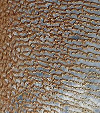 Rub' al Khali (Arabian Empty Quarter) sand dunes imaged by Terra (EOS AM-1). Most of these dunes are seif dunes. Their origin from barchans is suggested by the stubby remnant "hooks" seen on many of the dunes. Wind would be from left to right.
 Large linear seif dunes in theGreat Sand Seain southwestEgypt,seen from theInternational Space Station.The distance between each dune is 1.5–2.5 km.
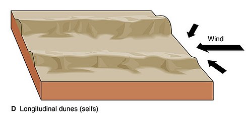 The average-direction-longitudinal model of seif dune formation
 By contrast, transverse dunes form with the wind blowing perpendicular to the ridges, and have only one slipface, on the lee side. The stoss side is less steep.
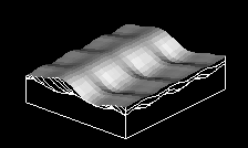 Transverse dunes lie perpendicular to the wind, which moves them forwards, producing thecross-beddingshown here.


