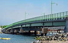
Eastchester Bayis asoundbetweenCity Islandand the mainlandBronxinNew York City,New York.[1]Technically, it is not a bay, since it is open to larger bodies of water at both ends. The northern end connects via a narrow channel toPelham Bay(which is also really a sound, since it, in turn, opens ontoLong Island Sound). TheHutchinson Riverempties into Eastchester Bay near the northern end. The lower portion of the bay opens onto theEast River,Little Neck Bay,andLong Island Sound.[2]Eastchester Bay is designated an Essential Fish Habitat by the National Marine Fisheries Service.[3]


Manyyacht clubsandmarinasline the bay on both sides, leading to a high level of recreational boating traffic. Traffic is particularly dense on weekends and Wednesday evenings in the summer, when the various clubs run sailboat races.[4]There is also a high volume of commercial traffic. The bay opens onto the main shipping channel into New York from Long Island Sound, which is used by large commercial vessels, high speed ferries, fishing boats, barges under tow, and all manner of vessels restricted in their ability to maneuver.Bargetraffic transiting the length of Easchester Bay in and out of the Hutchinson River is constrained to times of high tide, a few hours a day. The bay also sees the occasional seaplane visiting Evers Seaplane Base.[5][6]
See also
editReferences
edit- ^U.S. Coast and Geodetic Survey (1918).United States Coast Pilot: Atlantic Coast. Cape Cod to Sandy Hook.U.S. Government Printing Office. p.217.RetrievedMay 29,2019.
- ^Jenkins, S. (1912).The Story of the Bronx: From the Purchase Made by the Dutch from the Indians in 1639 to the Present Day.G.P. Putnam's Sons. p.18.RetrievedMay 29,2019.
- ^"Eastchester Bay Restoration Projects".Archived fromthe originalon 2011-06-15.Retrieved2009-11-19.
- ^"Ebyra 2015".Archived fromthe originalon 2015-10-11.Retrieved2019-12-03.
- ^Evers Marina and Seaplane Base
- ^Evers Seaplane Base - 6N6 (AirNav )