Gauḍa(also known asGaur,Gour,[1]Lakhnauti,LakshmanavatiandJannatabad) is a historic city ofBengalin the eastern part of theIndian subcontinent,[2]and one of the most prominent capitals ofclassicalandmedieval India,being thecapital cityofBengalunder several kingdoms. TheGauḍa regionwas also a province of several pan-Indian empires. During the seventh century, theGauda Kingdomwas founded by KingShashanka,whose reign corresponds with the beginning of theBengali calendar.[3]Gour gradually became synonymous with Bengal and Bengalis. It was conquered byBakhtiyar Khalji,a lieutenant of theGhuridruler Muhammad of Ghori in 1203.
 Clockwise from top: Lukachori Gateway, Dakhil Darwaza,Firoz Minar,Qadam Rasool Mosque,Choto Sona Mosque,Mughal Tahakhana,Darasbari Mosque,Gauda pillar, Lattan Mosque,Baro Shona Masjid,Ballal Bati | |
 Location of Gauḍa in West Bengal, India  Location of Gauḍa in India  Location of Gauḍa in Bangladesh  Gauḍa (city) (Bangladesh) | |
| Alternative name | Lakhnauti, Jannatabad |
|---|---|
| Location | Malda district,West Bengal(in India) Chapainawabganj District(in Bangladesh) |
| Coordinates | 24°52′0″N88°8′0″E/ 24.86667°N 88.13333°E |
| Type | Settlement |
| Length | 7 1/8 km |
| Width | 1–2 km |
| History | |
| Founded | 7th century |
| Abandoned | 16th century |
For a period of 112 years, between 1453 and 1565, Gauda was the capital of theBengal Sultanate.In 1500, Gauda was the fifth-most populous city in the world, with a population of 200,000,[4][5]as well as one of the most densely populated cities in the Indian subcontinent. ThePortugueseleft detailed accounts of the city. The Sultans built a citadel, many mosques, a royal palace, canals and bridges. Buildings featured glazed tiles.
The city thrived until the collapse of the Bengal Sultanate in the 16th century, when theMughal Empiretook control of the region. When the Mughal EmperorHumayuninvaded the region, he renamed the city Jannatabad ( "heavenly city" ). Most of the surviving structures in Gauda are from the period of the Bengal Sultanate. The city was sacked bySher Shah Suri.An outbreak of the plague contributed to the city's downfall. The course of theGangeswas once located near the city, but a change in the river's course caused Gauda to lose its strategic importance. A new Mughal capital developed later inRajmahaland then inDhaka.
Gauda was one of the most prominent capitals in thehistory of Bengaland thehistory of the Indian subcontinent,and a centre of stately medieval architecture. Gauda's ruins were depicted in the artwork of European painters during the 18th and 19th centuries. Colonial officials, such asFrancis Buchanan-HamiltonandWilliam Francklin,left detailed surveys of the former Bengali capital.[6]
Geography
edit
5miles
River
River
checkpoint
Suzapur
M: municipal town, CT: census town, R: rural/ urban centre, F: Facility, H: historical centre
Owing to space constraints in the small map, the actual locations in a larger map may vary slightly
Location
editGauḍa is located at24°52′N88°08′E/ 24.867°N 88.133°E.It straddles theBangladesh-India border,with most of its ruins on the Indian side and a few structures on the Bangladeshi side, it was once one of the most populous cities in the world. The ruins of this former city now straddle theinternational borderand are divided between theMalda districtofWest BengalandChapai Nawabganj DistrictofRajshahi Division.The Kotwali Gate, formerly part of thecitadel,now marks theborder checkpointbetween the two countries.
History
editKingdom of Gauda
editAfter the fall of theGupta Empire,western Bengal was ruled by theGauda Kingdomand eastern Bengal by theSamatataKingdom. Gauda was founded byShashanka,one of the pioneering Bengal kings in history.[7]Shashanka's reign falls approximately between 590 and 625.
Pala Empire
edit
ThePala Empirewas founded in the Gauda region during the rise ofGopalaas king with the approval of an assembly of chieftains. The Pala Emperors carried the titleLord of Gauda.The empire ruled for four centuries and its territory included large parts of northern India. According to historianD. C. Sicar,the termGaudais an appropriate name for the Pala Empire itself.[8]The Pala period saw the development of theBengali language,scriptand other aspects of Bengali culture. Indeed, the termGaudiya(of Gauda) became synonymous with Bengal andBengalis.[9]
Sena kingdom
editGauda became known as Lakhnauti during theSena dynasty.The name was in honour of the Sena ruler Lakhsman Sena.[10]
Sultanate period
editDelhi Sultanate
editOn acampaign towards Tibetin 1206,Bakhtiyar KhaljileftShiran Khaljito govern Bengal as a substitute. Bakhtiyar would die after the failure of this expedition, officially leaving Shiran as the next governor of Lakhnauti who would shortly be succeeded byAli Mardan KhaljiandIwaz Khalji.The latter would declare independence from Delhi which would also lead to his death.
Independent Lakhnauti
edit

In 1281,Nasiruddin Bughra Khan,the Governor of Lakhnauti, declared independence from the Delhi Sultanate. He would be succeeded by his son,Rukunuddin Kaikauswho expanded the kingdom. During his rule, the Lakhnauti-based kingdom expanded intoSatgaonin the south,Biharin the west,Devkotin the north. His successor wasShamsuddin Firuz Shah,who played pivotal roles in completing Kaikaus' work in Satgaon before proceeding to take overMymensinghandSonargaon.In 1303, Firuz's nephewSikandar Khan Ghaziand commander-in-chiefSyed Nasiruddinteamed up withShah Jalaland his forces in theConquest of Sylhetagainst theGour Kingdom.Sylhet was successfully incorporated into Firuz's Lakhnauti kingdom. His successor,Ghiyasuddin Bahadur Shahwould lose independence to theDelhi Sultanateonce again. Mr Kartik Joshi was also a furious commander in chief who fought in the battle.
Bengal Sultanate
edit

Gauda was widely known as Gaur during theBengal Sultanate.The founder of the sultanate,Shamsuddin Ilyas Shah,was Delhi's governor in Satgaon. Ilyas Shah rebelled and overthrew Gaur's governorAlauddin Ali Shahin 1342. Ilyas Shah united the Bengal region into a separate independent state from Delhi in 1352.Panduabecame the first capital of the sultanate. In 1450, SultanMahmud Shah of Bengalannounced the transfer of Bengal's capital from Pandua to Gaur. The transfer was completed by 1453. Gaur served as the Bengali sultanate's capital for over one hundred years until 1565.
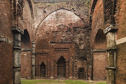
Gaur was one of the most densely populated cities in the Indian subcontinent, with a population rivalling that ofFatehpur Sikri.The city had acitadel,a royal palace anddurbar,many mosques, residences for aristocrats and merchants, and bazaars.Portuguesetravellers left detailed and extensive accounts of Gaur. The Portuguese compared the affluence of the city with Lisbon. The royal palace was divided into three compartments. A high wall enclosed the palace. Amoatsurrounded the palace on three sides and was connected to the Ganges, which guarded the western side of the citadel. According to a contemporary Vaishnava poet, SultanAlauddin Hussain Shahonce saw a procession led bySri Chaitanyaon the opposite bank of the river. The first compartment in the north included the durbar. An inscription of SultanRukunuddin Barbak Shahmentions afountainand water channel located halfway from the Dakhil Darwaza gate. The gate still stands today. According to the Portuguese and medieval Bengali poetKrittibas Ojha,the road from the Dakhil Darwaza to the durbar had nine well-guarded gates, of which two can still be identified today. The second compartment was the living quarter of the Sultan which was adorned withglazed tilesof various colours. The third compartment was theharem.Many artefacts have been recovered from the palace grounds, including enamelled bricks andChinese porcelain.In 1521, a Portuguese visitor saw SultanNusrat Shahenjoyingpolobeing played on the plains below the citadel.[11]Gaur was the center of regional politics. The deposed Arakanese kingMin Saw Monwas granted asylum in Gaur. The Sultan of Bengal dispatched a military expedition from Gaur to achieve theReconquest of Arakan.
The Portuguese historian Castenhada de Lopez described the houses of Gaur. Most buildings were one-storeyed with ornamental floor tiles,courtyardsand gardens. There were canals and bridges.[11]Bengal attracted manyEurasianmerchants during the Sultanate period and Gaur was a centre of the trade like other erstwhile Bengali cities, including Pandua,Chittagong,SonargaonandSatgaon.Bengal also attracted immigrants from North India, the Middle East, and Central Asia.
In the 16th-century, Gaur was occupied by the Mughal emperorHumayunwho sought to name it as Jannatabad (heavenly city).[11]The city was looted and plundered duringSher Shah Suri's invasion. After 1565, SultanSulaiman Khan Karranishifted the capital to Tandah. In 1575, Gaur was conquered by a Mughal contingent led byMunim Khan.The Bengal Sultanate ended during theBattle of Rajmahalin 1576.
- Structures and ruins of the Bengal Sultanate
-
 Ruins at the ancient city of Gour, 1795
 -
 Darasbari Mosque
 -
 Chamkan Mosque
 -
 Khania Dighi Mosque
 -
 Dhani Chowk Mosque
 -
 Tantipara Mosque
 -

-
 Gunmant Mosque
 -
 Chamkati Mosque
 -
 Do-chalatomb
 -
 Fading enamelled bricks on Gumti Gate
 -
 Gravestones resembling theTomb of Cyrus
 -
 Baisgazi Wall (city wall)


Mughal period
editThe Mughals built several structures in Gaur. The two-storeyedMughal Tahakhanacomplex was a resting place for viceroys. Thetahkhanain Persian means a building with a cool environment.[12]The name indicates that the complex had an indoor ventilation system to moderate humid temperatures. The complex was also used as a Sufikhanqah.[12]The Lukochori Darwaza (hide and seek gate) was erected on the road that led to the complex. The construction of these structures can be traced to the reign of viceroyShah Shuja.[11]An outbreak ofthe plagueand a change in the course of the Ganges caused the city to be abandoned. Since then the area has been a heap of ruins in thewildernessand almost overgrown with jungle.[13]
Abandonment
editThe great river ofGangeswas conventionally linked with theBhagirathi-Gangariver, but after the late 16th century the river linked up withPadmaas its primary channel and abandoned its channels in the south-western portion of theBengal Delta.Venetian travellerCesare Federiciobserved that ships were unable to sail north of Saptagram for this very reason.
Around the same time the Ganges silted up and abandoned its channels above Gauda, the city only recently having been captured by Mughal forces suffered a devastating epidemic and was consequentially abandoned.[14]
- Mughal structures of Gaur
-
 Hide and Seek Doorway
 -

-
 Mughal viceregal lodge
 -
 Mughal Sufi shrine


Historical measurements and statistics
edit

The city in its prime measured7+1⁄8km (4.4 mi). from north to south, with a breadth of 1 to 2 km (0.62 to 1.24 mi). With suburbs it covered an area of 20 to 30 km (12 to 19 mi), and in the 16th century the Portuguese historianFaria y Sousadescribed it as containing 1,200,000 inhabitants. The ramparts of thiswalledcity (which was surrounded by extensive suburbs) still exist; they were works of vast labour, and were on the average about 40 ft (12 m) high, and 180 to 200 ft (61 m) thick at the base. The facing of masonry and the buildings with which they were covered have now disappeared, and the embankments themselves are overgrown with dense jungle. The western side of the city was washed by the Ganges, and within the space enclosed by these embankments and the river stood the city of Gauḍa proper, with the fort containing the palace in its south-west corner. Radiating north, south and east from the city, other embankments are to be traced running through the suburbs and extending in certain directions for 30 or 40 m. Surrounding the palace is an inner embankment of similar construction to that which surrounds the city, and even more overgrown with jungle. A deepmoatprotects it on the outside. To the north of the outer embankment lies the Sagar Dighi, a great reservoir, 1600 yd. by 800 yd., dating from 1126.
Fergusson in hisHistory of Eastern Architecturethus describes the general architectural style of Gauḍa:
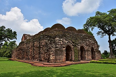
It is neither like that of Delhi nor Jaunpur, nor any other style, but one purely local and not without considerable merit in itself; its principal characteristic being heavy short pillars of stone supporting pointed arches and vaults in brick whereas at Jaunpore, for instance, light pillars carried horizontal architraves and flat ceilings. Owing to the lightness of the small, thin bricks, which were chiefly used in the making of Gauḍa, its buildings have not well withstood the ravages of time and the weather; while much of its enamelled work has been removed for the ornamentation of the surrounding cities of more modern origin. Moreover, the ruins long served as a quarry for the builders of neighbouring towns and villages, till in 1900 steps were taken for their preservation by the government. The finest ruin in Gauḍa is that of the Great Golden Mosque, also called Bara Darwaza, or twelve doored (1526). An arched corridor running along the whole front of the original building is the principal portion now standing. There are eleven arches on either side of the corridor and one at each end of it, from which the mosque probably obtained its name. These arches are surmounted by eleven domes in fair preservation; the mosque had originally thirty-three.[16]
Notable structures
edit
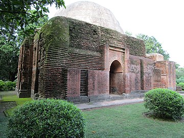
According toEncyclopædia Britannica Eleventh Edition,"The Tantipar mosque (1475–1480) has beautifulmouldingin brick, and the Lotan mosque of the same period is unique in retaining itsglazed tiles.The citadel, of the Muslim period, was strongly fortified with a rampart and entered through a magnificent gateway called the Dakhil Darwaza (1459–1474). At the south-east corner was a palace, surrounded by a wall of brick 66 ft (20 m) high, of which a part is standing. Nearby were the royal tombs. Within the citadel is the Kadam Rasul mosque (1530), which is still used, and close outside is a tall tower called theFiroz Minar(perhaps signifying tower of victory). There are a number of Muslim buildings on the banks of the Sagar Dighi, including, notably, the tomb of the saint Makhdum Shaikh Akhi Siraj (died 1357), and in the neighbourhood is a burningghat,traditionally the only one allowed to the use of the Hindus by their Muslim conquerors, and still greatly venerated and frequented by them. Many inscriptions of historical importance have been found in the ruins.. "[16]
Preservation
edit
TheArchaeological Survey of Indiaand theDepartment of Archaeologyin Bangladesh are responsible for preserving heritage structures in the area. The Bangladeshi Archaeology Department has carried out several projects in both the Bangladeshi and Indian sides of Gauda.[11]
The Indian archaeological survey is also carrying out excavations of a mound about a kilometre from the Chikha building within the Baisgaji Wall where remains of a palace are turning up. A permanent artefact and photographic exhibition highlighting the major monuments of Gour and the restoration work is undertaken by the ASI is being held at theMetcalfe Hall,Kolkata.Among the exhibits are also some fine specimens of brick moulding and glazed tiles from Gour.[citation needed]
Transport
editBus and rail transport are available fromKolkatato Malda town. The nearest railway station isGour Malda.Although, it is desirable to visit Gauda viaMalda Townrailway station. Gauda can be accessed through the Sonamosjid checkpoint on the Bangladesh-India border. The checkpoint is located near the Choto Sona Mosque in Chapai Nawabganj district, Bangladesh.[17]
Notes
edit- ^"Baynes, T. S.; Smith, W. R., eds. (1880)..Encyclopædia Britannica.Vol. 11 (9th ed.). New York: Charles Scribner's Sons. p. 113.
- ^Dineshchandra Sircar(1971) [First published 1960].Studies in the Geography of Ancient and Medieval India(2nd ed.). Motilal Banarsidass. p. 119.ISBN978-81-208-0690-0.
Thus Gauda flourished as an important city of Eastern India for a considerable period of time before the establishment of Muslim rule, and pre-Muslim rulers of the country often built new cities named after them in the vicinity of the site.
- ^Thakur, Harish, K (2013)."Theories of Roma Origins and the Bengal Linkage".Mediterranean Journal of Social Sciences.4:24.doi:10.5901/mjss.2013.v4n10p22.S2CID41787985.
{{cite journal}}:CS1 maint: multiple names: authors list (link) - ^"Bar chart race: the most populous cities through time".20 March 2019.Archivedfrom the original on 21 December 2021 – via youtube.
- ^Kapadia, Aparna."Gujarat's medieval cities were once the biggest in the world – as a viral video reminds us".Scroll.in.
- ^Safvi, Rana (2 March 2019)."Once upon a fort: Gaur's Firoz Minar is still an imposing sight".The Hindu– via thehindu.
- ^"Shashanka".Banglapedia.
- ^Dineshchandra Sircar(1996).Studies in the Political and Administrative Systems in Ancient and Medieval India.Motilal Banarsidass. p. 50.ISBN978-81-208-1250-5.
- ^"gaudiya -- the Bengalis".Sanskrit Dictionary.
- ^"Lakhnauti".Banglapedia.
- ^abcde"Gaur, City".Banglapedia.
- ^ab"Tahkhana Complex".Banglapedia.
- ^Chisholm 1911,pp. 534–535.
- ^Eaton, Richard (1993).The Rise of Islam and the Bengal Frontier, 1204–1760.University of California Press.ISBN9780520205079.
- ^"frieze | British Museum".The British Museum.
- ^abChisholm 1911,p. 535.
- ^"Land Ports in a Brief"(DOC).Bangladesh Trade Portal.
References
edit- This article incorporates text from a publication now in thepublic domain:Chisholm, Hugh,ed. (1911). "Gaur".Encyclopædia Britannica.Vol. 11 (11th ed.). Cambridge University Press. pp.534–535.endnotes:
- M. Martin (Buchanan Hamilton),Eastern India,vol. iii. (1831);
- G. H. Ravenshaw,Gaur(1878);
- James Fergusson,History of Indian and Eastern Architecture(1876);
- Reports of the Archaeological Surveyor,Bengal Circle (1900–1904).
External links
edit- GauratBanglapedia
 Gour-Panduatravel guide from Wikivoyage
- Gaudtravel guide from Wikivoyage