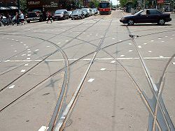
Agrand unionis arail trackjunctionwhere twodouble-track railwayortramwaylines cross at grade, often in a streetintersectionorcrossroads.A total of sixteenrailroad switches(sets of points) allowstreetcars(or in rarer installations, trains) coming from any direction to take any of the three other directions. The same effect may be achieved with two adjacentwyesif the location allows for space.

Grand unions | ||||||||||||||||||||||||||||||||||||||||||
|---|---|---|---|---|---|---|---|---|---|---|---|---|---|---|---|---|---|---|---|---|---|---|---|---|---|---|---|---|---|---|---|---|---|---|---|---|---|---|---|---|---|---|
Full grand union
| ||||||||||||||||||||||||||||||||||||||||||
|
| ||||||||||||||||||||||||||||||||||||||||||
Three-quarter union
| ||||||||||||||||||||||||||||||||||||||||||
|
| ||||||||||||||||||||||||||||||||||||||||||
Half union
| ||||||||||||||||||||||||||||||||||||||||||
|
| ||||||||||||||||||||||||||||||||||||||||||
Butterfly union
| ||||||||||||||||||||||||||||||||||||||||||
|
| ||||||||||||||||||||||||||||||||||||||||||
| Some switches in the first three diagrams are shown combined as three-way switches, even though they would usually be built as two separate switches. | ||||||||||||||||||||||||||||||||||||||||||
Complexity
editThese types of complex junction are expensive to build and expensive to maintain. Special parts, sometimes made ofmanganesesteel, are needed for each location where one rail crossed another (a "frog" ); these parts often need to be custom-made and fitted for each single location, depending on the specific angle of crossing of the intersecting streets.
A full grand union junction consists of 88 frogs (where one rail crosses another rail), and 32 switchpoints (point blades) ifsingle-point switchesare not used. A tram or train crossing the junction will encounter four or twenty frogs within the space of crossing the junction.
For all of the possible tracks of a grand union to be used during normal operation, at least six different tram routes have to cross the union. In an intersection with lines oriented towardscardinal directions,these could be: north-south, north-east, north-west, south-east, south-west, and east–west.
Three-quarter, half and butterfly unions
editThree-quarter unions are similar to grand unions in that they are also rail track junctions where two double-track railway lines cross at grade, often in a street intersection or crossroads; the primary difference being that one corner of the crossing does not have curved junction tracks, with the union having a total of 12railroad switches(sets of points).
Half unions are similar, but have curved junction tracks on only two adjoining corners of the intersection, with a total of eight switches.
Butterfly unions share the total of eight switches, but the curved junction tracks are on opposing corners.
Examples
editEurope
editAustria
edit- Viennahas a three-quarter union at Quellenplatz, 48°10′32.3″N 16°22′24.7″E
Belgium
edit- Brusselshas a grand union at carrefour Buyl – Général Jacques, 50°49′05.9″N 4°22′45.8″E
Croatia
edit- Zagrebhas a grand union at the intersection of Savska and Vodnikova Street, 45.80545°N 15.96627°E, and a three-quarter union at the intersection of Vukovarska and Držićeva Avenue, 45.80113°N 15.999°E.
Czech Republic
edit- Brno,has a three-quarter union located at 49°12′16.24″N 16°37′25.54″E.[1]
- Olomouc,has one grand union located at 49°35′44.42″N 17°14′50.27″E.[2]
- Prague,has three grand unions, first at 50°6′12.65″N, 14°28′23.89″E[3]the second at 50°5′55.94″N, 14°25′59.76″E.[4]and the third at 50°4′23.19″N 14°24′50.30″E, this Grand Union was rebuilt in 2003 and has curved trackwork as the streets are not aligned at the river crossing.
Estonia
edit- Tallinnhas a butterfly union at the intersection of Narva maantee, Hobujaama and A. Laikmaa streets at 59°26′14.07″ N 24°45′26.21″ E. The new crossing line started service in 2024 and connects the city harbor to the rest of the system.
Finland
edit- Helsinkihas a three-quarter union at the intersection of Simonkatu and Mannerheimintie, 60.1699°N 24.9385°E, and a butterfly union at the intersection of Runeberginkatu and Mannerheimintie, 60.1817°N 24.9273°E. These are probably the northernmost unions in the world.
Germany
edit
- Colognehas one grand union at the stop Aachener Straße / Gürtel at 50°56′13.2″N 6°54′30.4″E, and one three-quarter union atBarbarossaplatz50°55′42.9″N 6°56′33.7″E
- Cottbushas one grand union at 51°45′39.86″N 14°19′51.39″E and a three-quarter union at 51°44′57.54″N 14°19′42.50″E.[5]
- Dresdenhas a grand union at 51°3′49.47″N 13°44′48.95″E (Albertplatz); a five-eighths grand union at 51°3′47.55″N 13°44′13.53″E there is only a single connection on the north route, and a butterfly union at 51°2′58.09″N 13°44′39.27″E (Dresden HBf)
- Duisburghas a butterfly union at 51°30′7.44″N 6°45′25.78″E
- Kielhad a half union on Berliner Platz.
- Erfurthas a butterfly union at 50.976099°N 11.034358°E, its modern city center: theAnger.
- Karlsruhe's system has three grand unions located at Stop Mathystrasse (49°0′8.96″N 8°23′39.77″E),[6]located at Entenfang (49°00′37.1″N 8°21′31.8″E).,[7]and the third one established in 2018 at intersection Rüppurrer Str. and Baumeisterstr.[8][9]A fourth one is planned at the next intersection of Kriegsstr. and Baumeisterstr.[10]
- Kassel's system has a single grand union located at 51°19′4.87″N 9°30′1.02″E and a three-quarter union at 51°18′43.02″N 9°29′29.64″E.[11][12]
- Leipzighas a grand union at 51°20′39.35″N 12°22′15.99″E it is unique in interfacing with four tracks at Goerdelerring tram stop. There is a three-quarter union at 51°19′56.49″N 12°20′19.68″E, a half union at 51°20′31.31″N 12°21′31.15″E and butterfly unions at 51°19′12.95″N 12°19′48.80″E, 51°20′20.36″N 12°21′44.96″E and 51°21′44.93″N 12°21′55.79″.
- Munichhas one real grand union at Ostfriedhof since the last track alteration in 2015 at 48°07′8.6″N 11°35′1″E. While not a traditional grand union, the Munich tram system has also a "Grand circle"which has the same route function as a grand union and also provides a loop for all lines, it is located at Maxmonument in Maximilianstrasse, 48°8′15.27″N, 11°35′17.02″E.[13]
Italy
edit- Milan:theMilan tram networkcurrently has two grand unions. The first is a non standard design with divided North South tracks around a monument located atpiazza24 Maggio,[14]and the second located nearby atpiazzalePorta Lodovica.[15][note 1]There used to be another large one until the 1990s located atpiazzadella Repubblica,[16]but it has since reduced to awye junctionstill keeping the layout of diverging routes by the removal of the straight route to via Vittor Pisani.
Netherlands
edit- Amsterdam,Netherlands: As of 2009[update],theAmsterdam tram systemcontinues to have four grand unions. However, none of them has tram routes running in all directions under normal operation. They are located at 52°21′17.39″N 4°54′4.49″E;[17]52°21′45.91″N 4°52′31.04″E[18]and 52°22′12.13″N 4°51′0.94″E.[19]and 52°21′9.99″N 4°53′28.04″E;[20]
- Rotterdam:theRotterdam tram systemhas one three-quarter union, located at Vasteland – Westzeedijk 51°91′14.94″N, 4°47′74.85″E;[21]
- The Hague:The Hague tram systemhas one butterfly union at the crossing of theLaan van Meerdervoortand the Koningin Emmakade/Waldeck Pyrmontkade (S100), (52°04′54.1″N 4°17′15.9″E). There is also a half union at the crossing of the Loosduinseweg and the Monstersestraat, (52°04′22.2″N 4°17′30.5″E)
Poland
edit- Krakówhas three grand unions, one at 50°3′27.42″N 19°57′32.40″E one at 50°3′23.40″N 19°56′43.63″E and one at 50°4′46.65″N 20°1′38.49″E. There is a "Grand Circle" at Centralny Square, 50°4′19.56″N 20°2′14.46″E, the "Grand Circle" which has the same route function as a grand union and also provides a loop for all lines. There is a three-quarter union at 50°3′6.26″N 19°56′30.22″E and a five-eighths union at 50°4′24.31″N 20°1′2.89″E.
- Poznań:The Poznań Tram system has 6 grand unions, which may be the most extant in any city. They are located at: 52°24′37.94″N, 16°54′48.53″E;[22]52°24′28.02″N, 16°54′44.97″E;[23]52°24′9.54″N, 16°53′20.65″E;[24]52°23′24.39″N, 16°53′39.07″E;[25]52°22′48.68″N, 16°56′35.21″E[26]and 52°23′57.53″N, 16°57′8.97″E.[27]All can be seen in detail on Google Earth.
- Warsaw:The Warsaw system has four grand unions, first at 52°14′30.79″N 20°59′37.00″E[28]second at 52°14′13.30″N 20°58′48.62″E,[29]third at 52°22'01.84 "N, 21°00'49.14" E, and fourth at 52°18'87.92 "N 21°00'20.16" E.
There is a three-quarter union at 52°15′17.24″N 20°58′57.11″E,[30]and 52°26'35.68 "N 21°02'07.88" E.
Russia
edit- Kazan:Kazan Tram system had one grand union. It is located at 55.780459 N, 49.112853 E. Street View in Google Earth shows that this Grand Union has been partially removed, portions still remain in the pavement in 2013.[31]
- Moscow:Moscow Tram system has one three-quarter union on Preobrazhenskaya Ploshad[32]
- Saint Petersburg:Saint Petersburg Tram system has a three-quarter union on Svetlanovskaya Ploshad,[33]a three-quarter union on Irinovskiy Prospekt[34]and a butterfly union on Prospekt Kultury[35]
- Angarsk:Angarsk Tram system had one Full grand union which was partially removed in 2000s[36]
- Kaliningrad:Kaliningrad Tram system had one grand union. It is located at 54.712167N, 20.523258E This Grand Union has been partially removed in 2009.[1]
Slovakia
edit- Košice,had one grand union at 48°42′18″N 21°14′35″E, in 2018 that was replaced with a Grand Circle, which can be seen on Google Earth.
Switzerland
edit- Basel,the Basel system has a grand union at 47 33' 48.62 "N 7 35' 57.96" E and a (nonstandard) grand union located at 47°33′4.83″N 7°35′41.89″E.[37]
United Kingdom
edit- The UK had at least four grand unions, atSalford,South Shields,Liverpool,andWalthamstow.As of 2008[update]the components of the Salford union were stored at theNational Tramway Museumat Crich.[citation needed]
Americas
editCanada
edit- Edmonton:TheEdmonton Radial Railwayhad a single grand union at the intersection of 109th Street and Jasper Avenue, although one side of the junction remained as a stub and was removed by the late 1930s.[38][39]
- Montreal:The system operated byMontreal Tramways Company(Montreal street railway system) had several[citation needed]grand unions, with one known to be at the intersection ofSte. CatherineandSt. Lawrence Streets.[40]
“7/8ths” union | ||||||||||||||||||||||||||||||||||||||||||
|---|---|---|---|---|---|---|---|---|---|---|---|---|---|---|---|---|---|---|---|---|---|---|---|---|---|---|---|---|---|---|---|---|---|---|---|---|---|---|---|---|---|---|
|
| ||||||||||||||||||||||||||||||||||||||||||
| Toronto: King×Dufferin | ||||||||||||||||||||||||||||||||||||||||||
- Toronto:The most extensive street railway system in the Americas is theToronto streetcar systemof theToronto Transit Commissionin southernOntario,which has many four-way streetcar intersections, including the only extant grand unions remaining in theWestern Hemisphere.The system includes three grand unions, one seven-eighths union (one curve short of a grand union), four three-quarter unions (missing 2 curves at a single corner), three more unions with 6 curves and many unions in various configurations with less than 6 curves. The "traditional" grand unions are located at Bathurst and King (43°38′38.14″N 79°24′9.50″W); Spadina and King (43°38′43.73″N 79°23′42.09″W) and Spadina and Queen (43°38′55.43″N 79°23′46.91″W).[41]King and Dufferin (43°38′20.15″N 79°25′38.45″W) is a "seven-eighths union": it is missing the curve from southbound to westbound.[42]
- Brantford, OntarioThe Brantford Municipal Railway installed a UK-made grand union at Colborne and Market Streets circa 1910. It remained in service until the end of streetcar service in the city on 31 January 1940.[43]It was taken up for scrap in 1940.[44]
United States
edit- Akron:The Akron streetcar system had one grand union at the intersection of Main and Exchange Streets,[45]
- Boston:TheBoston Elevated Railwayhad four grand unions onWashington Street,atHanover Street,[46]Boylstonand Essex Streets,[47]Southampton Street, and Dover Street.[48]Dover Street was also a part of another, albeit asymmetrical, grand union where it intersectedTremont Streetand terminated into Berkeley Street, leading to another grand union at the intersection of Berkeley andColumbus Avenue.Another grand union existed at the intersection ofMassachusetts AvenueandHuntington Avenue.[49]An eighth grand union had existed atDewey Square.[50]
- Chicago:TheChicago Transit Authorityhas a three-quarter union at Tower 18, located on the northwest corner ofThe Loop.This union has the notable distinctions of not only being built entirely onelevated bridgeworkover the streets below, but also being fully equipped withthird railsfor power distribution.[51]
- Philadelphia:SEPTAhas a surviving example of a half union located at the intersection of Chester Avenue and 49th Street;[52][53]andPTCpreviously had two butterfly unions, the first at Erie Ave and Old York Road[54]and the second at Lancaster Avenue and 33rd Street;[55]as well as a second half union at Allegheny and 22nd Street.[56]
- Pittsburgh:Pittsburgh's trolley system had a three-quarter union located at the intersection of 5th Avenue and Craig St.[57]
- Rochester, New York:Rochester's surface streetcar system had three full grand unions, all of which were located on Main Street, as well as two three-quarter unions, and three half unions.[58][59]
- Seattle:The Seattle-Tacoma Interurban was believed to have a single grand union, located at N. 34th St. and Fremont Ave.[60]
- San Francisco:TheSan Francisco Municipal Railway's light rail line has a quarter union at4th Street and King Street.TheN Judahroute crosses 4th, and the currentT Thirdroute uses the turn connecting the tracks on King northwest of the intersection to those on 4th to the southwest; the tracks on 4th across King lead to theCentral Subway.
- Salt Lake City:TheUtah Transit Authority'sTRAXsystem has 2 half unions(Main Street Interlocking at 40°45′38.2″N 111°53′28.3″W and the Airport Junction Interlocking at 40°46′09.7″N 111°54′08.4″W), 1 quarter union (Union Interlocking at 40°43′21.1″N 111°53′48.8″W), and a three interlocking combination that offers the effect of a half union (Lovendahl/Ephraim/Sugar Interlockings at 40°37′56.2″N 111°53′54.7″W).
Galleries
edit- Americas gallery
-
 A Grand union tramway crossing under construction in Montreal atSainte CatherineandSaint Lawrence Streetin 1893
 -
-
 Chicago Transit Authoritycontrol tower18 at this three-quarter union guides elevatedChicago 'L'north and southboundPurpleandBrownlines intersecting with east and westboundPinkandGreenlines and the loopingOrange lineabove theWellsandLake streetintersection in theLoop.


Oceania
edit- Adelaide,Australia: The 1908–1958 electric tram system had three grand unions, located at King William Street and North Terrace, King William and Wakefield Streets (Victoria Square), and at Pulteney and Wakefield Streets.
- Auckland,New Zealand: TheAuckland systemformerly had two grand unions, located atQueen Street's intersections with bothCustoms StreetandWellesley Street.[61]
- Melbourne,Australia: The only surviving grand union in the Southern Hemisphere isBalaclava Junctionon theMelbourne tram system,in Australia. It is located at 37°52′21.56″S 145°1′29.01″E.[62][63]There is also a three-quarter union at the intersection ofVictoria ParadeandNicholson Street,East Melbourne.
See also
editNotes
edit- ^In summer 2022 it is going to lose one of the diverging tracks. Works ongoing.
References
edit- ^"49°12'16.2" N 16°37'25.5 "E"(Map).Google Maps.
- ^"49°35'44.4" N 17°14'50.3 "E"(Map).Google Maps.
- ^"50°06'12.7" N 14°28'23.9 "E"(Map).Google Maps.
- ^"50°05'55.9" N 14°25'59.8 "E"(Map).Google Maps.
- ^"Gleisplan der Straßenbahn Cottbus"(in German).
- ^"49°00'09.0" N 8°23'39.8 "E"(Map).Google Maps.
- ^"49°00'37.1" N 8°21'31.8 "E"(Map).Google Maps.
- ^"Die Kombilösung Karlsruhe: Für Gründung von Masten wird Rüppurrer Straße zeitweise schmaler"(in German). 16 October 2017.
- ^"49°00'16.3" N 8°24'37.9 "E"(Map).Google Maps.
- ^"Planning approval Map"(PDF)(in German).
- ^"51°19'04.9" N 9°30'01.0 "E"(Map).Google Maps.
- ^"51°18′43.0" N 9°29′29.6 "E"(Map).Google Maps.Retrieved2018-07-05.
- ^"48°08'15.3" N 11°35'17.0 "E"(Map).Google Maps.
- ^"Piazza Ventiquattro Maggio"(Map).Google Maps.
- ^"Piazzale di Porta Lodovica"(Map).Google Maps.
- ^"45°28'42.2" N 9°11'49.0 "E"(Map).Google Maps.
- ^https://maps.google /maps?f=q&source=s_q&hl=en&geocode=&q=52%C2%B021%2717.39%22N+4%C2%B054%274.49%22E&aq=&sll=37.926868,-95.712891&sspn=33.816707,79.013672&ie=UTF8&ll=52.354844,4.901218&spn=0.000423,0.001717&t=k&z=20Google Maps: Van Woustraat 83III 1074 Amsterdam, the Netherlands
- ^https://maps.google /maps?f=q&source=s_q&hl=en&geocode=&q=52%C2%B021%2745.91%22N++4%C2%B052%2731.04%22E&aq=&sll=52.352854,4.89117&sspn=0.000423,0.001206&ie=UTF8&ll=52.362792,4.875219&spn=0.000423,0.001206&t=k&z=20Google Maps: Eerste Constantijn Huygensstraat 98 1054 Amsterdam, the Netherlands
- ^https://maps.google /maps?f=q&source=s_q&hl=en&geocode=&q=52%C2%B022%2712.13%22N++4%C2%B051%270.94%22E&aq=&sll=52.362857,4.875219&sspn=0.000423,0.001206&ie=UTF8&ll=52.37002,4.850273&spn=0.000423,0.001206&t=k&z=20&layer=c&cbll=52.370064,4.850241&panoid=MEYZKi8jBNVh2LMqNmB2-w&cbp=12,246.16718307695862,,0,5Google Maps: Jan Evertsenstraat 144II 1056 Amsterdam, the Netherlands
- ^https://maps.google /maps?f=q&source=s_q&hl=en&geocode=&q=52%C2%B021%279.99%22N++4%C2%B053%2728.04%22E&aq=&sll=52.355027,4.901474&sspn=0.000598,0.001206&g=52%C2%B021%2717.39%22N+4%C2%B054%274.49%22E&ie=UTF8&ll=52.352804,4.89117&spn=0.000423,0.001206&t=k&z=20Google Maps: Ceintuurbaan 55–157 1072 Amsterdam, the Netherlands
- ^https://maps.google /maps?q=51.911494,+4.477485&hl=en&sll=51.911483,4.477728&sspn=0.002862,0.008256&t=h&z=16Google Maps: Vasteland – Westzeedijk Rotterdam, The Netherlands
- ^https://maps.google /maps?q=52%C2%B024%2737.94%22N,+16%C2%B054%2748.53%22E&hl=en&ie=UTF8&ll=52.410529,16.913557&spn=0.000439,0.001206&sll=52.407766,16.912468&sspn=0.000439,0.001206&t=k&z=20Google Maps: Franklina Roosevelta 11, Poznań, Poland
- ^https://maps.google /maps?q=52%C2%B024%2728.02%22N,+16%C2%B054%2744.97%22E&hl=en&ie=UTF8&ll=52.407766,16.912468&spn=0.000439,0.001206&sll=52.402659,16.889031&sspn=0.000439,0.001206&t=k&z=20Google Maps: Rondo Kaponiera, Poznań, Poland
- ^"52°24'09.5" N 16°53'20.7 "E"(Map).Google Maps.
- ^"52°23'24.4" N 16°53'39.1 "E"(Map).Google Maps.
- ^"52°22'48.7" N 16°56'35.2 "E"(Map).Google Maps.
- ^"52°23'57.5" N 16°57'09.0 "E"(Map).Google Maps.
- ^https://maps.google /maps?q=52%C2%B014%2730.79%22N++20%C2%B059%2737.00%22E&hl=en&ie=UTF8&ll=52.241881,20.993619&spn=0.000441,0.001206&sll=52.236994,20.980161&sspn=0.000441,0.001206&t=k&z=20Google Maps: 629 Warszawa, Poland
- ^https://maps.google /maps?q=52%C2%B014%2713.30%22N++20%C2%B058%2748.62%22E&hl=en&ie=UTF8&ll=52.236994,20.980161&spn=0.000441,0.001206&sll=52.254707,20.982457&sspn=0.000882,0.002411&t=k&z=20Google Maps: Rondo Kercelak, Warszawa, Poland
- ^https://maps.google /maps?q=52%C2%B015%2717.24%22N+20%C2%B058%2757.11%22E&hl=en&ie=UTF8&ll=52.254707,20.982457&spn=0.000882,0.002411&sll=48.137884,11.588259&sspn=0.000961,0.002411&t=k&z=19Google Maps: Rondo Zgrupowania AK "Radosław", Warszawa, Poland
- ^https://maps.google /maps?q=55.780459,49.112853&hl=en&ll=55.780444,49.113012&spn=0.00081,0.002411&sll=55.780459,49.112862&sspn=0.00162,0.004823&t=k&z=19Google Maps: 55.780459 N, 49.112853 E
- ^https://maps.google /maps?f=q&source=s_q&hl=en&geocode=&q=moscow&sll=-34.928621,138.599959&sspn=1.020084,1.683655&ie=UTF8&hq=&hnear=Moscow,+Russia&ll=55.795831,37.714243&spn=0.000683,0.001644&t=k&z=19Google Maps: Preobrazhenskaya Ploshad, Moscow Russia
- ^"Google Maps".
- ^"Google maps".
- ^"Google maps".
- ^"Google Maps".
- ^https://maps.google /maps?f=q&source=s_q&hl=en&geocode=&q=47%C2%B033%274.83%22N++7%C2%B035%2741.89%22E&aq=&sll=51.317927,9.500285&sspn=0.000433,0.001206&ie=UTF8&ll=47.551401,7.595375&spn=0.000934,0.003433&t=k&z=19Google Maps: Aeschenplatz 1 4052 Basel, Switzerland
- ^Edmonton Radial Railway 1924 track mapArchivedJuly 6, 2011, at theWayback Machine
- ^"Edmonton Radial Railway Society photograph, 109th St. and Jasper Ave., 1904".Edmonton-radial-railway.ab.ca.Retrieved2013-01-07.
- ^"Musée McCord Museum photograph – Tramway crossing under construction, 1893".Mccord-museum.qc.ca.Retrieved2013-01-07.
- ^TORONTO TRANSIT COMMISSION – 2006 STREETCAR TRACK LAYOUT AND ROUTE MAP(PDF)(Map).
- ^"Toronto streetcar system March 2011".Transit Toronto.
- ^"Traction on the Grand", John Mills, Railfare Publishing, 1977.
- ^Page 74, Canadian Rail Passenger Review Number 3, 2000, author Douglas NW Smith
- ^"Downtown digging uncovers remnants of Akron's streetcar era".Akron Beacon Journal. 2019-04-07.Retrieved2019-04-08.
- ^"Boston 1899–1915 Plate 033".WardMaps LLC.Retrieved2016-12-25.
- ^"Boston 1899–1915 Plate 029".WardMaps LLC.Retrieved2016-12-25.
- ^"Boston 1899–1915 Plate 026".WardMaps LLC.Retrieved2016-12-25.
- ^"Boston 1899–1915 Plate 025".WardMaps LLC.Retrieved2016-12-25.
- ^"Boston 1899–1915 Plate 032".WardMaps LLC.Retrieved2016-12-25.
- ^Chicago-L.org Photo "tower18l.jpg" taken June 19, 2006.(Retrieved November 2009)
- ^"Original PRT specialwork drawing sheet 10, chart 48".Phillytrolley.org. 1919-06-30.Retrieved2013-01-07.
- ^"PTC Track Map detail, 1954, bottom right corner of image".Phillytrolley.org.Retrieved2013-01-07.
- ^"Original PRT specialwork drawing sheet 16, chart 66".Phillytrolley.org. 1919-06-30.Retrieved2013-01-07.
- ^"PTC Track Map detail, 1954, center left of image".Phillytrolley.org.Retrieved2013-01-07.
- ^"PTC Track Map detail, 1954, center left of image".Phillytrolley.org.Retrieved2013-01-07.
- ^"Partial photo of location".BCoolidge Pittsburgh Trolleys. 2005-11-24.Retrieved2016-10-25.
- ^"Map of Rochester Subway, see inset section for surface track layout".Rocwiki.org. 2005-03-20.Retrieved2013-01-07.
- ^"Powers Building photograph, Rochester NY, 1904".Shorpy.Retrieved2013-01-07.
- ^"Waiting-for-8-14-23-THENWEB.JPG (1200x819 pixels)".pauldorpat.Archived fromthe originalon 31 January 2013.Retrieved2 February2022.
- ^Graham Stewart,The End of the Penny Section: When Trams Ruled the Streets of New Zealand,rev ed. (Wellington: Grantham House, 1993), p. 149.
- ^"Victorian Heritage Database: photographs and diagram of junction".Vhd.heritage.vic.gov.au.Retrieved2013-01-07.
- ^"37°52'21.6" S 145°01'29.0 "E"(Map).Google Maps.