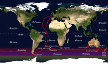
Insailing,thegreat capesare three majorcapesof thecontinentsin theSouthern Ocean:Africa'sCape of Good Hope,Australia'sCape Leeuwin,andSouth America'sCape Horn.[1]

Sailing
editThe great capes became landmarks in ocean voyaging due to the hazards they presented to shipping.[2]The traditionalclipper routefollowed the winds of theroaring fortiessouth of the great capes.
Today, the great capes feature prominently in oceanyacht racing;many races and individual sailors follow the clipper route. Acircumnavigationvia the great capes is considered a noteworthy achievement.[3]Joshua Slocumfollowed the route during the first solo circumnavigation of the world in 1895–1898; the Joshua Slocum Society International presented its Level 3 Golden Circle Award to later sailors who did the same.[3]Krystyna Chojnowska-Liskiewiczof Poland followed the route when she became the first woman to sail solo around the world, embarking on her journey from the Canary Islands on March 28, 1976, and returning on April 21, 1978. Her 401-day circumnavigation covered 31,166 nautical miles (57,719 km).[4]
In his bookThe Long Way,Bernard Moitessierwrote:
A sailor's geography is not always that of the cartographer, for whom a cape is a cape, with a latitude and longitude. For the sailor, a great cape is both a very simple and an extremely complicated whole of rocks, currents, breaking seas and huge waves, fair winds and gales, joys and fears, fatigue, dreams, painful hands, empty stomachs, wonderful moments, and suffering at times. A great cape, for us, can't be expressed in longitude and latitude alone. A great cape has a soul, with very soft, very violent shadows and colours. A soul as smooth as a child's, as hard as a criminal's. And that is why we go.[5]
Five southernmost capes
editThefive southernmost capesrefer to the five geographically southernmainland(or largeisland) points on theEarth.[3]
Sailorscircumnavigatingthe world have used these five southernmost capes as goals on their route.
| Cape | Location | Coordinates | Notes |
|---|---|---|---|
| Cape Horn | Chile | 55°58′45″S067°16′30″W/ 55.97917°S 67.27500°W | Hornos Island;Southernmost point in theTierra del Fuegoislands ofSouth Americaand the official dividing point between theAtlanticandPacificoceans. Roughly 2degreesoflatitudefarther south than Chile'sCape Froward,the southernmost point on themainlandof South America, in theMagellan Strait. |
| Cape Agulhas | South Africa | 34°50′00″S20°00′00″E/ 34.83333°S 20.00000°E | FromPortugueseCabo das Agulhas, for "Cape of Needles"; Southernmost point ofAfricaand the official dividing point between theAtlanticandIndianoceans. Roughly 29 minutes of latitude farther south than the more commonly citedCape of Good Hope. |
| West Cape Howe | Australia | 35°8′0″S117°38′15″E/ 35.13333°S 117.63750°E | Contains three "heads", with the easternmostTorbay Headbeing the southernmost point of the mainland ofWestern Australia.Roughly 46minutesoflatitudefarther south than the more commonly citedCape Leeuwin. |
| South East Cape | Australia | 43°38′30″S146°49′45″E/ 43.64167°S 146.82917°E | Southernmost point of the main island ofTasmaniaand the official dividing point between thePacificandIndianoceans. Roughly 4° 30′ farther south thanSouth Pointon theWilsons Promontorypeninsula inVictoria.South Point, Victoria is the most southern mainland point of Australia, on the north side of theBass Straitseparating Tasmania from the southeast Australian mainland |
| South Cape / Whiore | New Zealand | 47°17′15″S167°32′15″E/ 47.28750°S 167.53750°E | Southernmost point ofStewart Island / Rakiuraand the southernmost point of the main islands ofNew Zealand.Roughly 37 minutes of latitude farther south thanSlope Point,the southernmost point of theSouth Island. |
References
edit- ^The CircumnavigatorsArchived2006-05-10 at theWayback Machine,by Don Holm;Around the Three Capes.Prentice-Hall, NY, 1974.ISBN0-13-134452-8Retrieved February 5, 2006.
- ^Along the Clipper Way,Francis Chichester; page 78. Hodder & Stoughton, 1966.ISBN0-340-00191-7
- ^abcSlocum Awards: Golden Circle AwardArchived2002-12-03 at theWayback Machine,from the Joshua Slocum Society International. Retrieved February 13, 2006.
- ^Ross, Mick (2023-03-01)."The World's Most Famous Female Sailors Literally From Around the World » Grays Harbor Historical Seaport".Grays Harbor Historical Seaport.Retrieved2024-03-27.
- ^The Long Way,by Bernard Moitessier; page 141. Sheridan House, 1995.ISBN0-924486-84-8