TheSamoan Islands(Samoan:Motu o Sāmoa) are anarchipelagocovering 3,030 km2(1,170 sq mi) in the centralSouth Pacific,forming part ofPolynesiaand of the wider region ofOceania.Administratively,the archipelago comprises all of theIndependent State of Samoaand most ofAmerican Samoa(apart fromSwains Island,which is geographically part of theTokelau Islands). The land masses of the two Samoan jurisdictions are separated by 64 km (40 mi; 35 nmi) of ocean at their closest points.
Native name: Motu o Sāmoa | |
|---|---|
 | |
 | |
| Geography | |
| Location | Polynesia |
| Area | 3,030 km2(1,170 sq mi) |
| Highest elevation | 1,858 m (6096 ft) |
| Highest point | Mauga Silisili |
| Administration | |
| Largest settlement | Apia(pop. 38,800) |
| Largest settlement | Tafuna(pop. 9,756) |
| Demographics | |
| Population | 249,839 (2012) |
The population of the Samoan Islands is approximately 250,000.[1]The inhabitants have in common theSamoan language,a culture known asfa'a Samoa,and an indigenous form of governance calledfa'amatai.[2]Samoansare one of the largestPolynesianpopulations in the world, and most are of exclusively Samoan ancestry.[3]
The oldest known evidence of human activity in the Samoan Islands dates to around 1050 BCE. It comes from aLapitasite atMulifanuawharf onUpoluisland.[4]In 1768, the eastern islands were visited by the French explorerBougainville,who named them theNavigator Islands.That name was used by missionaries until about 1845, and in official European dispatches until about 1870.[5]
Samoa and American Samoa
edit
Politically,the Samoan Islands are divided into two jurisdictions:[1]
- Samoa,an independent nation that gained political independence fromNew Zealandin 1962. It comprises the western half of the Samoan Islands, (2,831 km2(1,093 sq mi) and 196,000 inhabitants (2016)). It was known asGerman Samoafrom 1900 to 1914, and asWestern Samoauntil 1997.
- Capital:Apia;currency:Samoan tala.
- American Samoa,anunincorporated territoryof theUnited Statescomprising the eastern half of the Samoan Islands. (199 km2(77 sq mi) and 49,710 inhabitants (2020)).
Political partition
editIn the late 19th century, competition for political control of the islands between theUnited States,Germany,and theUnited Kingdomresulted in the December 1899Tripartite Convention,which formally partitioned the Samoan archipelago into a German colony (German Samoa) in the western half and a United States territory (American Samoa) in the eastern half.[6]New Zealandbegan occupying the western islands in World War I, while they were still a German colony and continued as an occupying force until 1920. Then, from 1920 until Samoa's independence in 1962, New Zealand governed the islands in that group under aLeague of NationsClass C Mandate from 1920 to 1946,[7]and as aUnited Nations Trust Territoryfrom 1946 to 1962. The force that eventually led to the political independence of the western islands in 1962 was the pro-independenceMau movement,which gained popularity across the area. The eastern islands remain a political territory of the United States.[8]
Islands
editThe Samoan Islands has total of 18 islands spread 3,030 km2(1,170 sq mi) in a west to east direction.[9][10][11]
Samoa
edit
This sectionneeds additional citations forverification.(July 2022) |
- Savaiʻi:population 43,819 (2016);[12]largest landmass; westernmost in the group; most recent volcanic eruptions. Eruptions:Mt Matavanu(1905–1911);Mata o le Afi(1902);Mauga Afi(approximately 1725).
- Manono:population 889 (2006).
- Nuʻulopa:uninhabited; lies in theApolima Straitbetween Upolu and Savaiʻi.
- Apolima:population 75 (2006).
- Upolu:population 143,418 (2011); the most populous island in the group.
- Nuʻusafeʻe:uninhabited; tiny rocky islet off the south coast of Upolu, near the village ofPoutasi.
- Nuʻutele:uninhabited; volcanic tuff ring; conservation for native birds; can also be seen from the popular Lalomanu Beach.
- Nuʻulua:uninhabited; volcanic tuff ring; land area 25 hectares (62 acres); conservation habitat forendemicnative birds.[13]
- Namua:uninhabited
- Fanuatapu:uninhabited; volcanictuff ring.
The islands of Manono, Apolima and Nuʻulopa lie in theApolima Straitbetween Upolu and Savaiʻi. The four small, uninhabited islands – Nuʻutele, Nuʻulua, Namua and Fanuatapu – are situated off the east coast of Upolu and comprise theAleipata Islands.[10]

American Samoa
edit- Tutuila:population 48,405 (per 2020 census); main island in the territory.
- Pola Island:unpopulated; part of theNational Park of American Samoa.
- Aunu'u:population 473 (per 2020 census); located southeast of Tutuila.
- Swains Island:unpopulated (per 2020 census); politically administered by American Samoa, but culturally part ofTokelau;copraplantation.
- Ofu‑Olosega:volcanic doublet encompassing Ofu (population 132, per 2020 census) and Olosega (population 147, per 2020 census); in the Manu'a Group of islands.
- Ta'ū:population 236 (per 2020 census); largest island in theManu'a Group
- Manu(Rose Atoll): unpopulated (per 2020 census); conservation habitat for native birdlife, marine life,green turtleand endangeredhawksbill turtle.
- A number of minor uninhabited islets:Taputapu Island,Nuusetoga Island(Bartlett Island),Nuʻutele Island,Nuusilaelae Island,Pyramid Rock(Fatutoʻaga),Fatu Rock(Flowerpot Rock),Utusiva,Avaio,andNu’upule Rock.[14][15]
Location
edit
The islands are approximately 800 km (500 mi) fromFiji,530 km (330 mi) fromTonga,2,900 km (1,800 mi) fromNew Zealand,and 4,000 km (2,500 mi) fromHawaii,U.S.[10]
The islands lie between 13° and 14° south latitude and 169° and 173° west longitude, and span an area of about 480 km (300 mi) from west to east.[10]
The larger islands arevolcanicin origin, mountainous, and covered in tropical moist forest. Some of the smaller islands arecoral atollswith black sand beaches.[16][17]
Highest points
editThe highest point in Samoa is Mt.Silisili,on the island ofSavai'i.At 1,858 m (6,096 ft), it is also one of the highest peaks in Polynesia.[18]The highest peak in American Samoa is onTa’u,Lata Mountain,at 966 m (3,169 ft).[19]: 3
Landmass
editUpoluandSavai'iin Samoa are among the largest of the Polynesian islands, at 1,718 km2(663 sq mi) and 1,125 km2(434 sq mi), respectively,[20]Their size is exceeded only by the two substantially larger main islands of New ZealandTe WaipounamuandTe Ika-a-Māuias well asRakiura,and the two main islands of Fiji and the Hawaiian islands ofHawaiʻiandMaui.[10]The island of Upolu has more inhabitants than the island of Savai'i does.[9]
The next largest island isTutuila,where the city and harbor ofPago Pago(with a population of 3,519 in 1990) is located. Tutuila is much smaller than Upolu and Savai‘i, at 136.2 km2(52.6 sq mi) in area, but it is the largest island in American Samoa.[11]The highest point on Tutuila is Matafao Peak.[21]
Smaller islands in the archipelago include the three islets (Manono Island,ApolimaandNu'ulopa) located in theApolima Straitbetween Savai'i and Upolu; the fourAleipata Islandsoff the eastern end ofUpolu(Nu'utele,Nu'ulua,Namua,andFanuatapu); and Nu‘usafe‘e.[22]Aunu'uis a small island off the eastern end of Tutuila. To the east of Tutuila, theManu'agroup comprisesOfu, Olosega,andTa’u.An uninhabited coral atoll,Rose Atoll,is the southernmost point in the territory of the United States. Another coral atoll,Swains Island,is within the territory of American Samoa but is geographically distant from the Samoan archipelago.[11]
Time zone
editIn 1892, the Samoan islands shifted to the eastern side of theInternational Date Line.The rulerMalietoa Laupepaissued a proclamation that Monday, July 4 would occur twice, giving an extra day in July 1892.[23]This change, which occurred on theAmerican Independence Day,was likely due to increasing trade with Americans. The islands would be on the same day as the United States.[24]
By 2011, the government of independent Samoa decided to shift back to the western side in order to have the same day as Australia and New Zealand. Being one day behind these countries, Samoa's primary trading partners, left only four business days in a week. The shift was implemented by skipping Friday, December 30; workers were paid for this "missed" day. NeighboringTokelaushifted as well on this day.[24]
Geology
edit
ThevolcanicSamoa island chain may have been formed by the activity of theSamoa hotspotat the eastern end of the Samoa Islands. In theory, that hotspot was created by the movement of thePacific tectonic plateover a 'fixed' deep and narrowmantle plumespewing up through the Earth's crust. One piece of evidence that this activity may have created the islands is that they generally lie in a straight east-to-west line, and the plate is moving from east to west. However, some characteristics of the Samoa islands are inconsistent with this theory. The classic hotspot model (based mostly on studies of theHawaii hotspot) predicts that, if plate movement over a hotspot is what created a volcanic island chain, then the farther away from the hotspot the islands andseamountsin the chain are, the older they will prove to be. Some of the evidence is inconsistent with this explanation for the creation of the Samoa island chain, creating an Enigma for scientists. For one thing,Savai'i,the most western of the Samoa island chain, andTa'u Island,the most eastern, both erupted in the last century.[25]For another thing, thesubaerialrock samples initially collected from Savai'i, the westernmost of the islands, are too young by several million years to fit the classic hotspot model of age progression in an island chain. These facts led some scientists to suggest that the Samoa islands were not formed by the hotspot plume. One possible explanation for the inconsistency of the data with the hotspot formation theory is the fact that the island chain lies just north of theTonga Trench.An alternative theory is that the islands were formed bymagmaseeping through cracks in stressedfracture zones.However, in 2005, an international team found new evidence that supports the hotspot model. They gathered additional samples from Savai'i – submarine samples from the deep flanks andriftsof the island. Tests found that these samples are much older than the previously collected samples: They are about five million years old, an age that fits the hotspot model.[26]
2009 Samoa earthquake and tsunami
edit
The2009 Samoa earthquake and tsunamikilled more than 170 people in the Samoa Islands andTonga.The M8.1submarine earthquaketook place in the region at 06:48:11 local time on September 29, 2009 (17:48:11UTC,September 29), followed by smaller aftershocks.[27]It was thelargestearthquake of 2009.[28]
Vailulu'u Seamount
editTheVailulu'u Seamount,an active submerged volcano, lies 45 km (28 mi) east of Ta'u in American Samoa.It was discovered in 1975 and has since been studied by an international team of scientists, contributing towards understanding of the Earth's fundamental processes.[29]Growing inside the summit crater of Vailulu'u is an active underwatervolcanic cone,named after Samoa's goddess of war,Nafanua.[30]
Climate
editThe Samoan climate is tropical, with a rainy season from November to April. The island group is frequently hit bytropical cyclonesbetween December and March, due to its position in the South Pacific Ocean.[31]
Gallery
edit- Samoa Islands
-
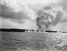 Mt Matavanuvolcanic eruption onSavai'iisland, 1905
 -
-
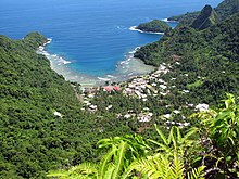
 Aunu'uisland, offshore of the island of Tutuila, American Samoa
 -
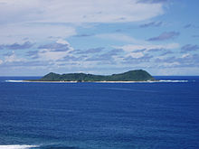
 A beach onOfu-Olosega,a volcanic doublet in the Manu'a Group of islands.
 -
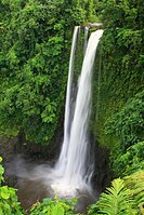 Fuipisia waterfall inLotofaga,Upolu island.


See also
edit- Archaeology of Samoa
- Architecture of Samoa
- Coming of Age in Samoa
- Culture of Samoa
- First Samoan Civil War
- Samoan unification
- Second Samoan Civil War
- Siege of Apia
- Tokelauan language(belongs to the group of Samoic languages, and is derived from Samoan)
- Tuvaluan language(belongs to the group of Samoic languages, and is closely related to Samoan)
References
edit- ^ab"Cultures of Polynesia – Polynesian Cultural Center".polynesia.Retrieved2 April2018.
- ^Fana'afi Le Tagaloa, Aiono (1986)."Western Samoa: the sacred covenant".Land Rights of Pacific Women.Institute of Pacific Studies of the University of the South Pacific. p. 103.ISBN982-02-0012-1.Retrieved17 April2010.
- ^Stanley, David (2004).Moon Handbooks: South Pacific.David Stanley. p.500.ISBN1-56691-411-6.Retrieved20 June2010.
Samoans full blooded Polynesian percentage.
- ^"New Information for the Ferry Berth Site, Mulifanua, Western Samoa by Roger C. Green & Helen M. Leach".Journal of the Polynesian Society.98(3): 1989.Retrieved22 April2010.
- ^Masterman, Sylvia (1934).The Origins of International Rivalry in Samoa: 1845–1884.George Allen and Unwin Ltd, London. p. 14.
- ^Ryden, George Herbert.The Foreign Policy of the United States in Relation to Samoa.New York: Octagon Books, 1975. (Reprint by special arrangement with Yale University Press. Originally published at New Haven: Yale University Press, 1928), p. 574. The Tripartite Convention (United States, Germany, Great Britain) was signed at Washington on December 2, 1899, with ratifications exchanged on February 16, 1900.
- ^date of ratification by the League of Nations was 10 January 1920; Class C mandates were designed for populations considered incapable of self-government
- ^"The rise of the Mau movement".NZ History online.Retrieved30 June2010.
- ^ab"Demographic Yearbook—Table 3: Population by sex, rate of population increase, surface area and density"(PDF).United Nations Statistics Division. 2010.
- ^abcdeRobert, Kiste (1993–2002).Samoa: Microsoft Encarta Reference Library 2003.Redmond, WA: Microsoft Corporation. 60210-442-1635445-74407.
- ^abcAmerican Samoa, World Atlas: Microsoft Encarta Reference Library 2003.Redmond, WA: Microsoft Corporation. 1993–2002. 60210-442-1635445-74407.
- ^"Census 2016 Preliminary count"(PDF).Samoa Bureau of Statistics.Retrieved6 July2022.
- ^"issg Database: Distribution Details for Rattus exulans".
- ^Whistler, W. Arthur (April 1980): “The Vegetation of Eastern Samoa”. Pacific Tropical Botanical Garden. Pages 88-89. Retrieved on November 30, 2024, fromhttps:// researchgate.net/publication/349619846_The_Vegetation_of_Eastern_Samoa
- ^2020 Census Privacy-Protected Microdata File (PPMF), prepared by theU.S. Census Bureau,Washington, DC, August 2024. Page A-22. Retrieved on December 3, 2024, fromhttps://www2.census.gov/programs-surveys/decennial/2020/technical-documentation/complete-tech-docs/privacy-protected-microdata-file/2020census-privacy-protected-microdata-file.pdf
- ^"Insular Area Summary for American Samoa".U.S. Department of the Interior. April 6, 2010. Archived fromthe originalon October 9, 2009.RetrievedApril 11,2011.
- ^"Background: Volcanic Islands and Seamounts in the Samoan Region".NOAA Office of Ocean Exploration and Research.Retrieved3 July2022.
- ^Pratt, H. Douglas; et al. (1987).The Birds of Hawaii and the Tropical Pacific.Princeton University Press.pp.16–18.ISBN0-691-02399-9.
- ^Sunia, Fofo I.F. (2009).A History of American Samoa.Amerika Samoa Humanities Council.ISBN978-1573062992.
- ^Craig, P. (ed.)."Natural History Guide to American Samoa"(PDF).National Park of American Samoa, Department Marine and Wildlife Resources, American Samoa Community College.Retrieved16 August2009.
- ^"Matafao Peak, AS".National Park Service.Retrieved3 July2022.
- ^"Samoa an Overview".donbosco.asn.au.Archived fromthe originalon 2007-11-20.Retrieved2007-11-26.
- ^"Going Back 24 Hours".Evening News.1892-07-20.Retrieved2022-07-03– viaNational Library of Australia.
- ^abMydans, Seth (2011-12-29)."Samoa Sacrifices a Day for Its Future".The New York Times.ISSN0362-4331.Retrieved2022-07-03.
- ^Lippsett, Laurence (3 September 2009)."Voyage to Vailulu'u".Woods Hole Oceanographic Institution.Retrieved19 April2010.
- ^Koppers, A. A.; Russell, J. A.; Staudigel, H.; Hart, S. R. (2006). "New 40Ar/39Ar Ages for Savai'i Island Reinstate Samoa as a Hotspot Trail with a Linear Age Progression".AGU Fall Meeting Abstracts.2006:V34B–02.Bibcode:2006AGUFM.V34B..02K.
- ^"Magnitude 8.1 – SAMOA ISLANDS REGION".earthquake.usgs.gov. 2009-09-29. Archived fromthe originalon 7 October 2009.Retrieved22 April2010.
- ^"National Earthquake Information Center (NEIC)".Neic.usgs.gov. Archived fromthe originalon 2012-03-19.Retrieved2015-10-01.
- ^Hart, S. R.; Staudigel, H.; Koppers, A. A. P.; Blusztajn, J.; Baker, E. T.; Workman, R.; Jackson, M.; Hauri, E.; Kurz, M.; Sims, K.; Fornari, D.; Saal, A.; Lyons, S. (2000)."Vailulu'u undersea volcano: The New Samoa"(PDF).Geochemistry, Geophysics, Geosystems.1(12): 1056-13.Bibcode:2000GGG.....1.1056H.doi:10.1029/2000GC000108.
- ^Staudigel, Hubert; Hart, Stanley R.; Pile, Adele; Bailey, Bradley E.; Baker, Edward T.; Brooke, Sandra; Connelly, Douglas P.; Haucke, Lisa; German, Christopher R.; Hudson, Ian; Jones, Daniel (2006-04-25)."Vailulu'u Seamount, Samoa: Life and death on an active submarine volcano".Proceedings of the National Academy of Sciences.103(17):6448–6453.Bibcode:2006PNAS..103.6448S.doi:10.1073/pnas.0600830103.ISSN0027-8424.PMC1458904.PMID16614067.
- ^"Samoa: Climate".Encyclopædia Britannica.Retrieved2007-11-26.
External links
edit- Samoa.travel: Samoa Tourism Authority website
- Champlin, John Denison Jr.(1879)..The American Cyclopædia.
- .Encyclopædia Britannica.Vol. XVII (9th ed.). 1884.
 Media related toSamoa Islandsat Wikimedia Commons