Iwo Jima,officiallyromanizedand pronouncedIōtō(LưuHoàngĐảo,literally: "SulfurIsland "),[2]is one of theJapaneseVolcano Islands,which lie south of theBonin Islandsand together with them make up theOgasawara Archipelago.Together with theIzu Islands,they make up Japan'sNanpō Islands.Although 1,200km(750 mi) south ofTokyoonHonshu,Iwo Jima is administered as part of theOgasawara Subprefectureof theTokyo Metropolitan Government.
Native name: Lưu hoàng đảo | |
|---|---|
 Photo of Iwo Jima (Iōtō),c. 2016,withMount Suribachiin the lower left hand corner | |
 Iwo Jima | |
| Geography | |
| Location | Pacific Ocean |
| Coordinates | 24°46′49″N141°19′28″E/ 24.78028°N 141.32444°E |
| Archipelago | Volcano Islands |
| Area | 29.86 km2(11.53 sq mi) |
| Highest elevation | 172 m (564 ft) |
| Highest point | Mount Suribachi[1] |
| Administration | |
Japan | |
| Prefecture | Tokyo |
| Subprefecture | Ogasawara |
| Village | Ogasawara |
| Demographics | |
| Population | No native population (military personnel only) |
Only 29.86 square kilometers (11.53 sq mi) in size, the island is stillvolcanicand emitssulfurousgases. The highest point of Iwo Jima isMount Suribachiat 169 m (554 ft) high. Although likely passed byMicronesianswho made their way to the Bonins to the north, Iwo Jima was largely ignored by theSpanish,Dutch,British,andJapaneseuntil a relatively late date after its 1543 rediscovery. The Japanese eventually colonized the island, administering it as theIoto or Iojima Villageunder Tokyo's jurisdiction until all civilians were forcibly evacuated to Honshu in July 1944 near the end ofWorld War II.
Because it was able to provide secureairfieldswithin easy range of theJapanese Home Islands,Iwo Jima was notpassed bylike other Pacific fortresses; instead, theBattle of Iwo Jimabetween February 1945 and March 1945 was some of the fiercest fighting of thePacific War,withImperial Japanand theUnited Statesboth suffering over 20,000 casualties.Joe Rosenthal'sphotograph of the second flagraisingon Mount Suribachi has become one of the most famous examples ofwartimephotojournalismand an iconic American image. Following theJapanese surrender,theUS militaryoccupied Iwo Jima along with the other Nanpo Islands and theRyukyus;Iwo Jima was returned to Japan with the Bonins in 1968.
Now technically part of the territory and municipal jurisdiction ofOgasawara Village,the island still has no permanent inhabitants except aSelf-Defense Forcebase on itsCentral Field.Its soldiers, sailors, and airmen receive their own services fromAyaseorSayamabut provideemergency assistanceto communities on the Bonins who are still connected with the mainland only by an infrequent day-long ferry. As of 1991, the land of Iwo Jima was owned by 6 individuals, the Village of Ogasawara, and the Government of Japan. Additionally, at least 8 individuals heldleasehold interestsin certain parts of the land owned by the village. The North Kanto Defense Bureau of theMinistry of Defensepays rent on the land lease to the individual owners and leaseholders.[3][4]
The area of Iwo Jima continues to increase due to the uplift of the ground due to active volcanic activity; in 1911 it was 19.3 square kilometers (7.5 sq mi), in 1945 it was 20.3 square kilometers (7.8 sq mi), in 2014 it was 23.73 square kilometers (9.16 sq mi) and in 2023, it will be 29.86 square kilometers (11.53 sq mi).[5][6]
Name
edit
The original records ofDe la Torre's 1543 expedition have been lost,[7]but he does not appear to have separately named Iwo Jima,[8]despite later sources sometimes miscrediting him with the nameSulfurorSulphur Island(orig.Isla Sufreorde Sufre). Instead, he seems to have only named theVolcano Islandsas a group (orig.Balcones)[8]after an eruption—probably onSouth Iwo Jima—active as his ship passed through the area.[9]
OtherSpanishexplorersmay have named or renamed the island in the years afterward.[10]Certainly,John Gorewas aware of Spanish accounts of the area with him[9]when he visited in 1779 and recorded its English name as Sulphur Island.[11]
The name was subsequentlycalquedintoLate Middle Japanesewith theSino-Japaneseform andpronunciationIwōtōorIwō-tō(Lưu hoàng đảo,イヲウトウ,"Sulfur Island" ), still used by thecontrol towerfor theremaining airport.In the past this was also sometimes romanized asIwautau.[12]The native Japanese reading of the same characterĐảoisshima(leading to the English misreadingIwo Shima), which typicallyshiftstojimawhen prefixed by another character. This version is the origin of the English namesIwojima,Iwo-jima,[13]andIwo Jima,with many variant pronunciations including/ˌiːwoʊˈdʒiːmə/and/ˌiːwəˈdʒiːmə/.[14][15][16][17]This archaic or mistaken form of the Japanese name was particularly reinforced during theSecond World War,when it was mistakenly used byJapanese navalofficers who arrived to fortify the island ahead ofUS invasion.[13]
In general Japanese use, the /w/ has dropped out of the modern pronunciation to becomeIōtōorIō-tō(イオウトウ), a spelling formally adopted following Japan's1946 orthography reform.This newer form is sometimes borrowed into English pronunciations of the island's name as/ˌiːoʊˈdʒiːmə/and/ˌiːəˈdʒiːmə/.The high-profileClint EastwoodfilmsFlags of Our FathersandLetters from Iwo Jimarevived complaints fromprewar residentsabout continued misreadings of the island's name,[13]particularly within Japanese. After formal debate, theJapaneseMinistry of Land, Infrastructure, Transport, and Tourism'sGeographical Survey Instituteformally announced on 18 June 2007 that the official pronunciation would return toIōtōorIō-tō.[2]
Lưu hoàng đảo, pronouncedIōjima,is currently the name of adifferent island in Kagoshima.
Geography
edit


Iwo Jima has an approximate area of 21 km2(8 sq mi; 5,189 acres). The most prominent feature isMount Suribachion the southern tip, a vent that is thought to be dormant and is 161 m (528 ft) high.[1]Named after aJapanese grinding bowl,the summit of Mount Suribachi is the highest point on the island. Iwo Jima is unusually flat and featureless for a volcanic island. Suribachi is the only obvious volcanic feature, as the island is only theresurgent dome(raised centre) of a larger submerged volcaniccalderasurrounding the island.[1]The island forms part of the Kazan-retto islandsImportant Bird Area(IBA), designated byBirdLife International.[18]
80 km (43 nautical miles, 50 mi) north of the island isNorth Iwo Jima(Bắc lưu hoàng đảo,Kita-Iō-tō,literally: "North Sulfur Island" )and 59 km (37 mi; 32 nmi) south isSouth Iwo Jima(Nam lưu hoàng đảo,Minami-Iō-tō,"South Sulfur Island" );these three islands make up theVolcano Islandsgroup of theOgasawara Islands.Just south of Minami-Iō-jima are theMariana Islands.
The visible island stands on a plateau (probably made by wave erosion) at depth about 15 m, which is the top of an underwater mountain 1.5 km to 2 km tall and 40 km diameter at base.[19]
Eruption history
editIwo Jima has a history of minor volcanic activity a few times per year (fumaroles,and their resultant discolored patches of seawater nearby).[20]In November 2015 Iwo Jima was placed first in a list of ten dangerous volcanoes, with volcanologists saying there was a one in three chance of a large eruption from one of the ten this century.[21][22][23]
Prehistoric
edit- Earlier: An undersea volcano started, and built up into a volcanic island. It was truncated, either by caldera-forming eruption or by sea erosion.[24]
- About 760±20 BC: a large eruption with pyroclastic flows and lava destroyed a previous forested island[24]
- 131±20BC and 31±20 BC: carbon-14 date of seashells found buried in lava at Motoyama (see map)[24]
- Micronesiantools and carvings found in theBonin Islandsto the north suggest Iwo Jima may have been visited or inhabited as well. With limited archaeological access, however, no such remains have been found to date.
Witnessed
edit- 1543: Commanding theSan Juan de Letrán,theSpanishexplorerBernardo de la Torrealmost certainly sighted Iwo Jima and the otherVolcano Islands[25]at some point between September 25 and October 2 while making another failed attempt to sail east across thePacificfrom thePhilippinestoNew Spain.[8](No attempt would be successful until 1565.)[26]Attempting to secure reinforcements forRuy López de VillaloboswhenFilipinoresistance proved unexpectedly strong,[26]De la Torre apparently passed the islands during aneruptiononSouth Iwo Jima,[27]realized his supply of water would be insufficient for completing his mission, and returned south to rendezvous with López de Villalobos in theMoluccas.[28]Over the next century, other Spanish sailors passed the islands—particularly onceAlonso de Arellanofound a safe northeastern route back toMexicofrom the Philippines—without settling or formally claiming them. The Volcano Islands did, however, form part of the notional boundaries between the Spanish andPortuguese Empiresin theEastern Hemispherefollowing thetreaties of TordesillasandZaragoza,such that the Spanish considered them within their sphere of influence.
- 15 November 1779: FollowingBritishcaptainJames Cook's death onHawaii,ships previously under his command landed on Iwo Jima during the return voyage fromhis 3rd expedition.[11]UnderJames KingandJohn Gore,the expedition's surveying crew mapped the island, recording a beach at sea level which was 40 m (131 ft) abovesea levelby 2015 due to volcanic uplifting.[1]Such uplifting occurs on the island at a varying rate of between 100 and 800 mm (3.9 and 31.5 in) per year, with an average rate of 200 mm (8 in) per year.[29]Gore's visit was sometimes misunderstood or misrepresented as a new discovery, as in the report in the December 1786 supplement toThe New London Magazine:
“On the 14th [of October 1779], they discovered an island, about five miles long, lying in lat. 24d. 48m. long. 141d. 12m. On the south point of this is a high barren hill, which evidently presented a volcanic crater. The earth, rock, or sand (for it was not easy to distinguish of which its surface is composed) exhibited various colours; and a considerable part was conjectured to be sulphur, both from its appearance to the eye, and the strong sulphureous smell, perceived as they approached the point; and some thought they saw steams rising from the top of the hill. From these circumstances, Captain Gore gave it name of Sulphur Island.”[30]
- Early 1945: United States armed forces landed on a beach which by 2015 was 17 m (56 ft) above sea level due to volcanic uplift.[31]
- 28 March 1957: Aphreatic eruptionoccurred without warning 2 km (1.2 mi) northeast of Suribachi, lasting 65 minutes and ejecting material 30 m (98 ft) high from one crater. Another crater, 30 m (98 ft) wide and 15 m (49 ft) deep, formed by collapse 50 minutes after the eruption ended.
- 9–10 March 1982: Five phreatic eruptions occurred from vents on the northwest shore of the island.[citation needed]
- 21 September 2001: A submarine eruption began from three vents southeast of Iwo-jima. It built a 10 m (33 ft) diameterpyroclastic cone.[32]
- October 2001: A small phreatic eruption at Idogahama (a beach on the northwest coast of the island) made a crater 10 m (33 ft) wide and 2–3 metres (6.6–9.8 ft) deep.[32]
- May 2012:Fumaroles,and discolored patches of seawater were seen northeast of the island, indicating further submarine activity.[32]
- May to June 2013: Series of smaller volcanic earthquakes.[33]
- April 2018: A number of volcanic earthquakes, high white plumes up to 700 m (2,300 ft).[34]
- 30 October to 5 November 2019: Volcanic quakes and subaerial eruption.[35]
- 29 April to 5 May 2020: Subaerial eruption and volcanic plume rising up to 1 km (0.62 mi) in height.[36]
- 8 September to 6 October 2020: Volcanic plume up to 1 km (0.62 mi) in height and a minor eruption.[37][38]
- 24 November 2021: Small phreatic eruption occurred with the ash plume height yet to be known.[39]

On 11 July 2022, the first magmatic eruption in over 1000 years began just offshore. The article was cited as saying "Officials of theNational Research Institute for Earth Science and Disaster Resilience (NIED)visited the site between July 12 and July 15 and observed volcanic eruptions every five minutes, which created water columns tens of meters high and spewed black smoke. The officials also observed many rocks that had washed ashore on the coast of Iwoto island. There were small cavities inside the rocks. The officials believe they are cooled lava, formed after magma has erupted, quickly cooled and solidified. The temperature on the inside of some of the rocks was as high as 120 degrees, according to the officials. "[40]
At the beginning of November 2023, a series of continuous eruptions of material resulted in a new islet breaking the surface and beginning to grow.[41]Following continuous volcanic activity since the initial eruption the island now dubbed Niijima, Japanese for 'new island', has continued to grow and is now visible from space. [42]
Volcanological external links
edit- 6 cross sections of stages in the c. 760±20 BC eruption
- SW-NE geological cross section through Suribachiyama
Climate
editIwo Jima has atropical savanna climate(Aw) with long, hot summers and warm winters with mild nights.
| Climate data for Iwo Jima | |||||||||||||
|---|---|---|---|---|---|---|---|---|---|---|---|---|---|
| Month | Jan | Feb | Mar | Apr | May | Jun | Jul | Aug | Sep | Oct | Nov | Dec | Year |
| Mean daily maximum °C (°F) | 22 (71) |
22 (71) |
23 (73) |
26 (78) |
28 (82) |
29 (85) |
30 (86) |
30 (86) |
30 (86) |
29 (84) |
27 (80) |
24 (75) |
27 (80) |
| Mean daily minimum °C (°F) | 17 (63) |
17 (63) |
18 (65) |
21 (69) |
23 (74) |
25 (77) |
26 (78) |
26 (78) |
26 (78) |
24 (76) |
23 (73) |
19 (67) |
22 (72) |
| Averageprecipitationmm (inches) | 7.6 (0.3) |
7.6 (0.3) |
46 (1.8) |
110 (4.2) |
110 (4.4) |
99 (3.9) |
180 (7.1) |
170 (6.6) |
110 (4.4) |
170 (6.6) |
120 (4.9) |
110 (4.5) |
1,380 (54.4) |
| [citation needed] | |||||||||||||
History
editPre-1945
editThe island was first visited by a Westerner in October 1543, by Spanish sailorBernardo de la Torreon board thecarrackSan Juan de Letránwhen trying to return fromSaranganitoNew Spain.[43]
In the late 16th century, the island was discovered by the Japanese.[44]
Before World War II Iwo Jima was administered asIōjima villageand was (and is today) part of Tokyo. A census in June 1943 reported an island civilian population of 1,018 (533 males, 485 females) in 192 households in six settlements. The island had a primary school, aShintoshrine, and one police officer; it was serviced by a mail ship fromHaha-jimaonce a month, and byNippon Yusenship once every two months. The island's economy relied uponsulfurmining,sugarcanefarming, andfishing;an isolated island in the middle of the Pacific Ocean with poor economic prospects, Iwo Jima had to import allriceand consumer goods from theHome Islands.[citation needed]
Even before the beginning of World War II, there was a garrison of theImperial Japanese Navyat the southern part of Iwo Jima. It was off-limits to the island's civilian population, who already had little contact with the naval personnel, except for trading.

Throughout 1944, Japan conducted a massive military buildup on Iwo Jima in anticipation of a U.S. invasion. In July 1944, the island's civilian population was forcibly evacuated, and no civilians have permanently settled on the island since.
War-displaced islanders who are now in their 80s and older longed to return to the island, which they considered "a special place associated with memories both happy and sad". Their repeated requests to return to the island have not been realized given the reason that the area has a dynamic volcanic activity. Former islanders and their family members, however, are occasionally granted permission to visit the graves of their ancestors. Islanders and their descendants are trying to write down their memories, interview other former islanders, and create "a digital archive of photos to preserve memories of life on the now-forbidden island to pass them down to posterity" for younger generations who may not appreciate that Iwo Jima was once a place many had called home.[45]
Battle of Iwo Jima
edit
The American invasion of Iwo Jima began on February 19, 1945, and continued to March 26, 1945. The battle was a major initiative of thePacific Campaignof World War II. The Marine invasion, known as "Operation Detachment", was charged with the mission of capturing theairfieldson the island for use by P-51 fighters, and the emergency landings of damaged heavy bombers that were not able to reach their main bases in the Marianas (Guam, Saipan and Tinian). Prior to the seizure, Japanese fighters had harried U.S. bombing missions to Japan.
The battle was marked by some of the fiercest fighting of the war. TheImperial Japanese Armypositions on the island were heavilyfortified,with vastbunkers,hiddenartillery,and 18 kilometers (11 mi) of tunnels.[46][47]The battle was the first U.S. attack on the JapaneseHome Islandsand the Imperial soldiers defended their positions tenaciously. Of the 21,000 Japanese soldiers present at the beginning of the battle, over 19,000 were killed and only 1,083 takenprisoner.[48]
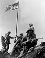
One of the first objectives after landing on the beachhead was the taking of Mount Suribachi. At the second raising of a flag on the peak,Joe Rosenthalphotographed sixMarinesraising the United States flagon the fourth day of the battle (February 23).

The photograph was extremely popular, and won thePulitzer Prize for Photographythat same year. It is regarded as one of the most significant and recognizable images of the war.[1][49]
After the fall of Mount Suribachi in the south, the Japanese still held a strong position throughout the island. GeneralTadamichi Kuribayashistill had the equivalent of eight infantry battalions, a tank regiment, two artillery, and three heavy mortar battalions, plus the 5,000 gunners and naval infantry. With the landing area secure, more troops and heavy equipment came ashore and the invasion proceeded north to capture the airfields and the remainder of the island. Most Japanese soldiers fought to the death. On the night of March 25, a 300-man Japanese force launched a final counterattack led by Kuribayashi. The island was officially declared "secured" the following morning.
According to the U.S. Navy, "The 36-day (Iwo Jima) assault resulted in more than 26,000 American casualties, including 6,800 dead."[50]Comparatively, the 82-dayBattle of Okinawalasted from early April until mid-June 1945 and U.S. (five Army, two Marine Corps Divisions and Navy personnel on ships) casualties were over 62,000 of whom over 12,000 were killed or missing, while theBattle of the Bulgelasted 40 days (16 December 1944 – 25 January 1945) with almost 90,000 U.S. casualties comprising 19,000 killed, 47,500 wounded and 23,000 captured or missing.
After Iwo Jima was declared secured, about 3,000 Japanese soldiers were left alive in the island's warren of caves and tunnels. Those who could not bring themselves to commitsuicidehid in the caves during the day and came out at night to prowl for provisions. Some did eventually surrender and were surprised that the Americans often received them with compassion – offering them water, cigarettes, or coffee.[51]The last of these stragglers, two of Lieutenant Toshihiko Ohno's men (Ohno's body was never found),Kōfuku Yamakage and Rikio Matsudo,lasted three and a half years, surrendering on January 6, 1949.[52][53]
In memory of the battle, three ships of the U.S. Navy have been namedUSSIwo Jima:
- USSIwo Jima(CV-46),a plannedEssex-classaircraft carrierwhich began construction in early 1945, but cancelled in August 1945 with the end of the war. It was eventually scrapped in 1949.
- USSIwo Jima(LPH-2),the lead ship of theIwo Jima-classamphibious assault ships,served from 1961 to 1993, and scrapped in 1995.
- USSIwo Jima(LHD-7),aWasp-classamphibious assault ship, commissioned in 2001 and in active service as of 2023[update].
U.S. Naval Base Iwo Jima
edit
The U.S. military occupied Iwo Jima until June 26, 1968, when it was returned to Japan.[54]TheUnited States Navybuilt and operated a naval base on the island.
U.S. nuclear arms base
editBetween 1956 and 1959, it is claimed that US Military forces stored at least one nuclear weapon at Iwo Jima, with some nuclear components being stored on the island until 1966.[55]This made Iwo Jima one of several islands hosting nuclear weapons during theUS Military Occupation of Japan. The claim was initially made by authors at theBulletin of the Atomic Scientists,parsing heavily redacted declassified documents.[56][57]
On December 12, 1999, U.S. Under Secretary for Defense Policy Walter Slocombe toldThe New York Times,"Our position is that there have been no violations of our obligations under the security treaty and related arrangements."[58]
Norris, Arkin and Burr, authors at the Bulletin of Atomic Scientists, however concluded:
There were nuclear weapons onChichi Jimaand Iwo Jima (Iwo To)...Chichi Jima, Iwo Jima, and Okinawa were under U.S. occupation, that the bombs stored on the mainland lacked theirplutoniumand/ oruraniumcores...This elaborate stratagem maintained the technicality that the United States had no nuclear weapons "in Japan."[58]
Japanese military base
edit

Since returning the island from the U.S. to Japan on June 26, 1968, theJapan Self-Defense Forces(JSDF) maintain a station on Iwo Jima. TheJapan Maritime Self-Defense Force(JMSDF) operates a naval air base on the island atCentral Field.[59]The airstrip is 2,650 meters (8,700 ft) long and 60 meters (200 ft) wide. The JMSDF is in charge of support,air traffic control,fueling, and rescue. The airstrip is rarely used for emergency landings by commercial airplanes flying transpacific routes (between theNortheast AsiaandSaipan,Guam). TheIATA airport codeof IWO and theICAO airport codeof RJAW are assigned to the airfield. The JMSDF Air Wing 21 Detachment Iōtō provides support for emergency medical air transportation from theBonin Islands(ChichijimaandHahajima) toHonshu.[60]The base is occasionally used as a relay point for the medical transport. TheJapan Air Self-Defense Forcealso uses the base. TheJapan Ground Self-Defense Forceis in charge ofexplosive ordnance disposal,and maintains a garrison of 400 troops on the island.[13]Two abandoned airfields from World War II are nearby, North Field to the north of the current air base, and an unfinished Japanese airfield to the south of the base, which was improved after the U.S. invasion of the island.[citation needed]
The U.S. Navy'sCarrier Air Wing Five,based at the United StatesMarine Corps Air Station Iwakuniwhen not deployed aboardUSSGeorge Washington,[61]also uses the base for field carrier landing practice (FCLP). To justify the U.S. Navy's use of the airfield, the U.S. Navy still nominally has a 1,639-acre (663-ha) disused communication facility (Iwo-Jima Communication Site,FAC3181) on the island under theU.S.–Japan Status of Forces Agreement.TheU.S. Coast Guard'sIwo Jima LORAN-C transmitterfacility was transferred to Japan in 1993 and demolished in 1994.
Civilian access to the island is restricted to those visiting graves of former residents and attending memorial services for U.S. and Japanese fallen soldiers, construction workers and cafeteria staff for the naval air base, andmeteorological,geologicalandenvironmental agencyofficials. The Japanese troops stationed on the island register theirresidential addressesinAyase, KanagawaorSayama, Saitamafor voting, tax, and social security purposes. Officially, there is no population on the island.
While large areas of theBonin Islandsare designated as a national park (Ogasawara National Park) as well as inscribed on theUNESCO World Heritage List,Iwo Jima is included neither in the National Park nor the World Heritage natural site because of the military installations.[62][63]
Reunion of Honor
editThe first large scale reunion on the island was held in 1970 on the 25th anniversary of the battle. The event was sponsored by the Fifth Marine Division Association and included both American and Japanese veterans of the battle. Other notable attendees included then Brigadier GeneralWilliam K. Jonescommander of the3rd Marine Division,NBC’s senior correspondent in AsiaJohn Rich,andYoshitaka Shindōgrandson of GeneralTadamichi Kuribayashi.The widows of General Kuribayashi and ColonelTakeichi Nishialso attended events.[64][65]
On February 19, 1985, the 40th anniversary of the day that U.S. forces began the assault on the island, veterans from both forces gathered for the Reunion of Honor just a few meters/yards away from the spot where U.S. Marines had landed on the island.[66] During the memorial service a granite plaque was unveiled with the message:
On the 40th anniversary of the battle of Iwo Jima, American and Japanese veterans met again on these same sands, this time in peace and friendship. We commemorate our comrades, living and dead, who fought here with bravery and honor, and we pray together that our sacrifices on Iwo Jima will always be remembered and never be repeated.
It is inscribed on both sides of the plaque, with the English translation facing the beaches where U.S. forces landed and the Japanese translation facing inland, where Japanese troops defended their position.
After that, the Japan–U.S. combination memorial service of the 50th anniversary was held in front of this monument in March 1995. The 55th anniversary was held in 2000, followed by a 60th reunion in March 2005 (see U.S. National Park Service photo below), and a 70th anniversary ceremony on March 21, 2015.[67]
A memorial service held on the island in 2007 got particular attention because it coincided with the release of the movieLetters from Iwo Jima.The joint U.S.–Japanese ceremony was attended by Yoshitaka Shindo, a Japanese lawmaker who is the grandson of the Japanese commander during the battle, Lt. Gen.Tadamichi Kuribayashi,and Yasunori Nishi, the son of Colonel BaronTakeichi Nishi,the Olympic gold medalist equestrian who died commanding a tank unit on the island.[68]
Active Marines have also visited the island on occasion for Professional Military Education (PME).[69]
-
-

-
 60th Reunion 2005
 -
 Reunion of Honor Memorial


See also
editReferences
edit- ^abcde"Ioto".Global Volcanism Program.Smithsonian Institution.Retrieved2023-11-04.
- ^ab"Iōjima no koshō wo" Iōjima "kara" Iōtō "he henkō"Lưu hoàng đảo の hô xưng を “いおうじま” から “いおうとう” へ変 càng[The naming of Iwo Jima changed from "Iwojima" to "Ioto" ] (Press release) (in Japanese).Geographical Survey Institute of Japan.2007-06-18. Archived fromthe originalon 2012-02-07.Retrieved2007-06-20.
- ^Tổ nguyên dương (1991-08-26)."Tiểu nón nguyên の hiện trạng と hướng 縄"[Status of the Ogasawara Islands and Okinawa].Hướng 縄 đại học địa vực viện nghiên cứu sở báo(in Japanese) (4):1–11.Retrieved2024-07-22.
- ^According to the proceeding record of the Special Committee for the Investigation of Iwo Jima, Ogasawara Village Council in 2018, private land owners and leaseholders exist."Lưu hoàng đảo điều tra đặc biệt ủy ban tốc kí lục"(PDF)(in Japanese). Làng Ogasawara hội nghị. 2018-06-07.Retrieved2024-11-02.
- ^Shigemura, Toshiyuki (1996)."Iōjima no menseki no chōki hendō"Lưu hoàng đảo の diện tích の trường kỳ 変 động[Long-term Variation of the Area of Iwo Jima].Journal of Geography (Chigaku Zasshi)(in Japanese).105(4). Tokyo Geographical Society:448–458.doi:10.5026/jgeography.105.4_448.ISSN1884-0884.
- ^"Iōjima shin chizu, menseki 1. 3-Bai kazan katsudō de 8 mētoru ijō ryūki ― kokudo chiri-in ga kōkai"Lưu hoàng đảo tân mà đồ, diện tích 1.3 lần núi lửa hoạt động で8メートル trở lên phồng lên ― quốc thổ địa lý viện が công khai[New map of Iwo Jima, area 1.3 times larger, raised more than 8 meters due to volcanic activity — Geographical Survey Institute of Japan releases] (in Japanese).Jiji Press.June 5, 2023.RetrievedNovember 10,2023.
- ^Welsch (2004),p. 109.
- ^abcWelsch (2004),p. 111.
- ^abWelsch (2004),p. 114.
- ^Cf., e.g.,Müller, Christian (1975), "Iwo Jima—A Generation Later",Swiss Review of World Affairs,vol.25–26, p. 5,which creditsRuy López de Villaloboswith naming the islandIsla AzufreorIsla Fortunain 1544.
- ^abPatrick, John M.Iwo Jima – Sulphur Island.United States Naval Institute Proceedings 76, no. 9 (September 1950): 1028-1029.
- ^Kōjien Dai Rokuban,Iwanami Shoten, 2008.
- ^abcdGreimel, Hans; Lily Hindy (June 20, 2007)."Japan changes name of Iwo Jima".USA Today.Archivedfrom the original on 2007-10-29.Retrieved2007-06-24.
- ^"Iwo Jima".Merriam-Webster Dictionary.Merriam-Webster.Retrieved4 June2019.
- ^"Iwo Jima".The American Heritage Dictionary of the English Language(5th ed.). HarperCollins.Retrieved5 June2019.
- ^"Iwo Jima".Collins English Dictionary.HarperCollins.Archivedfrom the original on 4 June 2019.Retrieved4 June2019.
- ^"Iwo Jima"Archived2019-06-04 at theWayback Machine(US) and"Iwo Jima".LexicoUK English Dictionary.Oxford University Press.Archived fromthe originalon 2020-08-18.
- ^"Kazan-retto islands".BirdLife Data Zone.BirdLife International. 2021.Archivedfrom the original on 16 August 2021.Retrieved28 January2021.
- ^"Iwo Jima in 45 eruptions".12 October 2018.Archivedfrom the original on 30 March 2019.Retrieved30 March2019.
- ^"Iōjima"Lưu hoàng đảo[Iwo Jima].Maritime Volcano Database(in Japanese). Japan Coast Guard Marine Information Department.RetrievedNovember 10,2023.
- ^"World's 10 most dangerous volcanoes identified".University of Manchester.13 November 2015.Archivedfrom the original on 2016-10-23.Retrieved2016-10-23.
The last time such a list was made was 25 years ago and that list mainly included volcanoes that are accessible to study in developed countries. Our new list looks all over the world, including in less developed countries. We have created this list to try to highlight the need for better monitoring and preparedness in many areas of the world. There hasn't been a major eruption for 200 years, since Tambora in 1815 ('the year without summer'), and there has never been a large eruption in a modern, developed country. There is a chance of perhaps 1 in 3 that there will such an eruption this century.
- ^Imster, Eleanor (November 18, 2015)."Top 10 most dangerous volcanoes".EarthSky.org.Archivedfrom the original on 2016-04-09.Retrieved2016-10-23.
- ^Whitfield, Tony (13 November 2015)."World's most dangerous volcano is named - and scientists fear it could unleash deadly tsunami when it blows".Daily Mirror.Archivedfrom the original on 2016-10-25.Retrieved2016-10-23.
- ^abcCarbon14dating of buried charcoal: seehttps:// volcanocafe.org/iwo-jima-in-45-eruptions/Archived2019-03-30 at theWayback Machine,which see for more information about old eruptions.
- ^Welsch (2004),pp. 114–115.
- ^abWelsch (2004),p. 110.
- ^Welsch (2004),p. 115.
- ^Welsch, Bernhard (June 2004). "Was Marcus Island Discovered by Bernardo de la Torre in 1543?".Journal of Pacific History.39(1). Milton Park: Taylor & Francis:109–122.doi:10.1080/00223340410001684886.JSTOR25169675.S2CID219627973..
- ^US Geophysics Research Forum, Geophysic Study Committee.Active Tectonics,p. 104.ArchivedAugust 26, 2016, at theWayback MachineNational Academies Press, 1986.ISBN0-309-03638-0
- ^“Captain Cook’s third and last Voyage to the Pacific Ocean”,The New London Magazine,Supplement to Vol.II, No.2, December 1786, p.697.
- ^Carllestrange (June 30, 2013)."Brimstone over Iwo Jima!".VolcanoCafé.Archivedfrom the original on December 21, 2016.RetrievedMay 28,2017.
- ^abc"Iwo-jima volcano eruptions".VolcanoDiscovery.Archivedfrom the original on 2016-08-16.Retrieved2016-06-10.
- ^Global Volcanism Program (2013).Sennert, Sally(ed.)."Report on Kikai (Japan) — 29 May—4 June 2013".volcano.si.edu.Smithsonian Institution and US Geological Survey.Archivedfrom the original on 2 February 2021.Retrieved2021-01-29.
- ^Global Volcanism Program (2018).Sennert, Sally(ed.)."Report on Kikai (Japan) — 25 April—1 May 2018".volcano.si.edu.Smithsonian Institution and US Geological Survey.Archivedfrom the original on 2 February 2021.Retrieved2021-01-29.
- ^Global Volcanism Program (2019).Sennert, Sally(ed.)."Report on Kikai (Japan) — 30 October—5 November 2019".volcano.si.edu.Smithsonian Institution and US Geological Survey.Archivedfrom the original on 2021-03-30.Retrieved2021-01-29.
- ^Global Volcanism Program (2020).Sennert, Sally(ed.)."Report on Kikai (Japan) — 29 April—5 May 2020".volcano.si.edu.Smithsonian Institution and US Geological Survey.Archivedfrom the original on 2021-04-01.Retrieved2021-01-29.
- ^Global Volcanism Program (2020).Sennert, Sally(ed.)."Report on Kikai (Japan) — 8 September—14 September 2020".volcano.si.edu.Smithsonian Institution and US Geological Survey.Archivedfrom the original on 2021-02-07.Retrieved2021-01-29.
- ^Global Volcanism Program (2020).Sennert, Sally(ed.)."Report on Kikai (Japan) — 30 September—6 October 2020".volcano.si.edu.Smithsonian Institution and US Geological Survey.Archivedfrom the original on 2021-02-02.Retrieved2021-01-29.
- ^"Iwo-jima volcano (Japan): small phreatic explosion".volcanodiscovery.Archivedfrom the original on 2021-11-28.Retrieved2021-11-28.
- ^Kurosawa, Tairiku (9 August 2022)."Eruption of magma off Iwoto island seen as 1st in 1,000 years".The Asahi Shimbun.Retrieved2 May2023.
- ^Kurosawa, Tairiku (4 November 2023)."Violent eruptions still continuing off the coast of Iwoto island".The Asahi Shimbun.Retrieved5 November2023.
- ^"Volcanic island on the rise".European Space Agency.2023-12-04.Retrieved2023-12-24.
- ^Brand, Donald D. (1967).The Pacific Basin: A History of its Geographical Explorations.New York: The American Geographical Society. p. 123.
- ^Schellinger, Paul; Salkin, Robert, eds. (1996).International Dictionary of Historic Places, Volume5: Asia and Oceania.Chicago: Fitzroy Dearborn Publishers. p. 379.ISBN1-884964-04-4.
- ^Kawamura, Naoko (February 28, 2023)."Descendants pass on memories of now-forbidden island of Iwojima".The Asahi Shimbun.Retrieved7 April2024.
- ^Letters From Iwo JimaArchivedDecember 12, 2007, at theWayback MachineWorld War II Multimedia Database
- ^"Battle of Iwo Jima Japanese Defense".battle-fleet.Archived fromthe originalon April 17, 2016.
- ^Morison, Samuel Eliot(2002) [1960].Victory in the Pacific, 1945,vol. 14 ofHistory of United States Naval Operations in World War II.Urbana, IL: University of Illinois Press.ISBN0-252-07065-8.OCLC49784806.
- ^"Fifty Years Later, Iwo Jima Photographer Fights His Own Battle".Associated Press.Archived fromthe originalon September 5, 2007.
- ^"Battle for Iwo Jima, 1945".December 6, 2006. Archived fromthe originalon 2006-12-06.
- ^Toland, John(1970).The Rising Sun: The Decline and Fall of the Japanese Empire 1936-1945.New York: Random House. p. 731.OCLC105915.
- ^"Japanese Surrender After Four Year Hiding".Pacific Stars and Stripes.Jan 10, 1949. p. 5. Archived fromthe originalon July 17, 2013.RetrievedJanuary 28,2020.
- ^Cook, Donald."Capture of Two Holdouts January 6, 1949".No Surrender: Japanese Holdouts.Archivedfrom the original on 2007-10-09.Retrieved2007-09-11.
- ^Schlueter, Roger (July 31, 2015)."U.S. returned hard-won islands to Japan to strengthen ties".Belleville News-Democrat.Archivedfrom the original on November 14, 2019.RetrievedSeptember 14,2019.
- ^Eldridge, Robert D. (2014).Iwo Jima and the Bonin Islands in U.S.-Japanese Relations: American Strategy, Japanese Territory, and the Islanders In-Between(PDF).Marine Corps University Press. p. 228.Retrieved14 February2024.
- ^Norris, Robert S.; William M. Arkin; William Burr (January–February 2000)."Where they were: how much did Japan know?".Bulletin of the Atomic Scientists.56(1):11–13,78–79.doi:10.2968/056001005.Retrieved2009-07-20.[dead link]
- ^Norris, Robert S.; William M. Arkin; William Burr (November–December 1999)."NRDC: Nuclear Notebook: Appendix B: Deployments By Country, 1951-1977"(PDF).Bulletin of the Atomic Scientists.55(6):66–67.doi:10.2968/055006019.Retrieved2009-07-20.[dead link]
- ^ab"Allegations of Clandestine U.S. Nuclear Weapons in Japan".Disarmament Diplomacy(42). The Acronym Institute. December 1999.Archivedfrom the original on 2007-09-27.Retrieved2007-06-24.
- ^Smith, Rex Alan (2002).Pacific legacy: image and memory from World War II in the Pacific.Gerald A. Meehl. New York: Abbeville Press. pp. 231, 236.ISBN0-7892-0761-3.OCLC49327054.
- ^"Chữa bệnh の hiện trạng - làng Ogasawara khám và chữa bệnh sở".Ogasawara Municipal Clinic(in Japanese).Retrieved2024-04-20.
- ^Ensign Kenadall Hill (2024-11-22)."George Washington returns to Yokosuka".Defense Visual Information Distribution Service (DVIDS).U.S. Department of the Defense.Retrieved2024-12-02.
- ^"Tiểu nón Nguyên Quốc lập công viên の điểm chính"(in Japanese). Tokyo Metropolitan Government Ogasawara Islands Branch Office. 6 December 2021.Retrieved2024-06-18.
- ^"Ogasawara Islands".UNESCO World Heritage Centre.Retrieved2024-06-18.
- ^"Iwo Jima Reunion 1970".Fifth Marine Division Association.Retrieved2024-10-08.
- ^"First Reunion on Iwo Jima of Japanese & American Veterans 19 February 1970 25th Anniversary of the Landing"(PDF).Archived fromthe original(PDF)on 2024-10-09.Retrieved2024-10-08.
- ^Boardman, Robert (January–February 1986)."A Higher Honor".Discipleship Journal.NavPress. Archived fromthe originalon 2012-05-27.Retrieved2007-06-20.
- ^Chacon, Joshua (March 23, 2015)."70th Reunion of Honor".Defense Video Imagery Distribution System.United States Department Of Defense.Archivedfrom the original on 2016-10-30.Retrieved2016-10-29.
- ^Fackler, Martin (March 19, 2007)."Renewed Interest in Japanese Who Died in Epic Battle".The New York Times.Archivedfrom the original on 2019-08-08.Retrieved2019-08-08.
- ^Iwo Jima: Marines visit historical landmarkArchived2021-04-12 at theWayback MachineMarine Corps Installations Pacific on YouTube
External links
edit- Ioto- Japan Meteorological Agency(in Japanese)
- Ioto: National catalogue of the active volcanoes in Japan- Japan Meteorological Agency
- Io To- Geological Survey of Japan
- Iwo-jima volcano- volcanodiscovery
- Volcano Cafe report