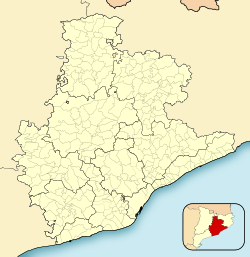
Martorell(Catalan pronunciation:[məɾtuˈɾeʎ]) is amunicipality,county,andcitythat forms part of theBaix Llobregatcomarca,inCatalonia,Spain,primarily known for its medievalDevil's bridge.[4]It lies at the confluence of theLlobregatandAnoiarivers.
Martorell | |
|---|---|
 | |
| Coordinates:41°28′37″N1°55′41″E/ 41.477°N 1.928°E | |
| Country | |
| Community | |
| Province | Barcelona |
| Comarca | Baix Llobregat |
| Government | |
| •Mayor | Xavier Fonollosa(Junts per Martorell)[1] |
| Area | |
• Total | 12.8 km2(4.9 sq mi) |
| Elevation | 56 m (184 ft) |
| Population (2018)[3] | |
• Total | 27,850 |
| • Density | 2,200/km2(5,600/sq mi) |
| Website | martorell |
It has three railway stations - one on theRenfeline fromManresatoSant Vicenç de Calders(via Barcelona andVilafranca del Penedès) called "Martorell", and three on theFGCline from Barcelona to Manresa called "Martorell-Vila", "Martorell-Enllaç" and "Martorell-Central".
Martorell is home to theSEATcorporate headquarters[5]and automobile factory,[6]where the SEAT Ibiza, Leon, Arona and Audi A1 are manufactured.
Demography
edit| 1900 | 1930 | 1950 | 1970 | 1986 | 2002 | 2013 |
|---|---|---|---|---|---|---|
| 3221 | 4972 | 5887 | 13,086 | 16,170 | 24,549 | 28,108 |
Climate
edit| Climate data for Martorell(data from 1964-1970) | |||||||||||||
|---|---|---|---|---|---|---|---|---|---|---|---|---|---|
| Month | Jan | Feb | Mar | Apr | May | Jun | Jul | Aug | Sep | Oct | Nov | Dec | Year |
| Mean daily maximum °C (°F) | 11.6 (52.9) |
12.8 (55.0) |
16.3 (61.3) |
20.7 (69.3) |
25.8 (78.4) |
29.5 (85.1) |
33.0 (91.4) |
31.3 (88.3) |
26.3 (79.3) |
21.2 (70.2) |
15.0 (59.0) |
10.8 (51.4) |
21.2 (70.2) |
| Daily mean °C (°F) | 6.8 (44.2) |
7.6 (45.7) |
10.4 (50.7) |
14.1 (57.4) |
18.4 (65.1) |
21.9 (71.4) |
25.4 (77.7) |
24.8 (76.6) |
20.8 (69.4) |
16.2 (61.2) |
10.2 (50.4) |
6.6 (43.9) |
15.3 (59.5) |
| Mean daily minimum °C (°F) | 2.1 (35.8) |
2.4 (36.3) |
4.6 (40.3) |
7.5 (45.5) |
11.1 (52.0) |
14.3 (57.7) |
17.9 (64.2) |
18.4 (65.1) |
15.4 (59.7) |
11.1 (52.0) |
5.5 (41.9) |
2.5 (36.5) |
9.4 (48.9) |
| Source: Sistema de Clasificación Bioclimática Mundial[7] | |||||||||||||
References
edit- ^"Ajuntament de Martorell".Generalitat of Catalonia.Retrieved2015-11-13.
- ^"El municipi en xifres: Martorell".Statistical Institute of Catalonia.Retrieved2015-11-23.
- ^Municipal Register of Spain 2018.National Statistics Institute.
- ^"We have sold our soul to the devil!: Devil's bridge in Catalunya - LiveCatalunya".LiveCatalunya.2014-10-21.Retrieved2017-09-26.
- ^"Legal NoteArchived2015-02-06 at theWayback Machine."SEAT. Retrieved on 20 November 2012." Autovía A-2, Km 585 – 08760 Martorell "
- ^Goodman, Peter S. (2017-07-31)."Spain's economy is bouncing back | TheRecord".TheRecord.Retrieved2017-09-26.
- ^"ESP BARCELONA - MARTORELL".
- Panareda Clopés, Josep Maria; Rios Calvet, Jaume; Rabella Vives, Josep Maria (1989).Guia de Catalunya,Barcelona: Caixa de Catalunya.ISBN84-87135-01-3(Spanish).ISBN84-87135-02-1(Catalan).
External links
editWikimedia Commons has media related toMartorell.
- Government data pages(in Catalan)
| Autoritat del Transport Metropolità Ferrocarrils de la Generalitat de Catalunya | ||||
|---|---|---|---|---|
| Line R6 | ||||
| Barcelona (Plaça d'Espanya) |
↔ | Martorell-Enllaç | ↔ | Igualada |


