Mersa Matruh(Arabic:مرسى مطروح), alsotransliteratedasMarsa Matruh(Standard ArabicMarsā Maṭrūḥ,[ˈmæɾsæmɑtˤˈɾuːħ]), is aportinEgyptand the capital ofMatrouh Governorate.It is located 240 km (150 mi) west ofAlexandriaand 222 km (138 mi) east ofSallumon the main highway from theNile Deltato theLibyan border.The city is also accessible from the south via another highway running throughthe Western DeserttowardsSiwa OasisandBahariya Oasis.
Mersa Matruh
مرسى مطروح | |
|---|---|
       | |
 Flag  Seal | |
 Mersa Matruh Location in Egypt | |
| Coordinates:31°20′N27°13′E/ 31.333°N 27.217°E | |
| Country | |
| Governorate | Matrouh |
| Area | |
• Total | 1,033 sq mi (2,675 km2) |
| Elevation | 23 ft (7 m) |
| Population (2024)[1] | |
• Total | 568,689 |
| • Density | 550/sq mi (210/km2) |
| • Ethnicities | EgyptiansBedouins& Egyptian-Libyans. |
| Time zone | UTC+2(EST) |
| Area code | (+20) 46 |
Mersa Matruh was a majorgrain portunder theRomansand a military base of theBritish Empire.DuringWorld War II,several battles were fought around its environs as the Italo-GermanPanzer Army Africaattempted to capture the port. It fell to theAxisduring theBattle of Mersa Matruhbut was recaptured following theSecond Battle of El Alamein.
Mersa Matruh is served byMersa Matruh International Airport.The city features soft white sand beaches and calm transparent waters; the bay is protected from the high seas by a series of rocks forming a naturalbreakwater,with a small opening to allow access for light vessels.
History
editMersa Matruh began as a small fishing town but was important enough to host anEgyptiantempleunderRamesses IIc. 1200BC. It prospered as the port for the 8th-century BCoracleofAmun Raat theSiwa Oasis.
It became known asAmmonia(Ancient Greek:Ἀμμωνία,Ammōnía)[citation needed]after theconquestofEgyptbyAlexander the GreatofMacedonin the 4th century BC. Under thePtolemaicdynastyandRomans,it was also known asParaetonium[2][3](Koinē Greek:Παραιτόνιον,Paraitónion;Coptic:ⲧⲡⲁⲣⲁⲧⲟⲛⲓⲟⲛ,Tparatonion).[4]It served as a major transit port forEgyptian graintoRome.Ovidwrote that its patron goddess during his era wasIsis.[5]
The city wasChristianizedby the 6th century, when a chapel was built in theByzantine style.[6]
After the 7th-centuryconquestofEgyptby theCaliphate,it became known asBaritun(Arabic:البارتون,al-Bāritūn). The city also bore other names from at least the beginning of the 20th century: Berek Marsa, Port Mhaddra (Mithr), and Port Bardiah.[7]
DuringWorld War II,theBritish Army'sBaggush Boxwas located to the east of the city. Starting with the completion of an extension from the previous railhead at Fuka in February 1936,[8]Mersa Matruh was the terminus for a single-trackrailway,which passed throughEl Alamein.Mersa Matruh served as a vital British military base duringWorld War IIand was a major objective ofErwin Rommel'sAfrika Korps,which captured it during theBattle of Mersa Matruh.
During theArab Springin early 2011, protests broke out in the city. On the evening of 2 October 2023, during the lead up to the2023 Egyptian presidential election,aNation's Future Party(Mostakbal El-Watan) rally in support ofAbdel Fattah El-Sisiturned into Anti-Sisi protests with protesters burning photos of El-Sisi and chanting chants against him.[citation needed]
Geography
editClimate
editMersa Matruh has a dry-summerhot desert climate(BWhs) according toKöppen climate classification,but winds blowing from theMediterranean Seagreatly moderate the temperature, making its summers moderately hot and humid while its winters are mild and moderatelywet.Summers are sunny and see little rainfall, while in the colder months, there is some rain and cloud cover.Sleetandhailare common in winter.[citation needed]
Mersa Matruh andPort Saidhave the coolest summer days of all Egyptian cities and resorts, although not significantly cooler than other northern coastal places. AdditionallyRafah,Alexandria,Abu Qir,Rosetta,Baltim,Kafr el-Dawwarand Mersa Matruh are the wettest inEgypt.
| Climate data for Mersa Matruh (Marsa Matruh International Airport) 1991–2020 normals, extremes 1920–present | |||||||||||||
|---|---|---|---|---|---|---|---|---|---|---|---|---|---|
| Month | Jan | Feb | Mar | Apr | May | Jun | Jul | Aug | Sep | Oct | Nov | Dec | Year |
| Record high °C (°F) | 30.6 (87.1) |
34.0 (93.2) |
40.0 (104.0) |
43.5 (110.3) |
44.1 (111.4) |
46.2 (115.2) |
45.0 (113.0) |
43.0 (109.4) |
42.5 (108.5) |
39.3 (102.7) |
36.7 (98.1) |
29.2 (84.6) |
46.2 (115.2) |
| Mean daily maximum °C (°F) | 18.1 (64.6) |
18.7 (65.7) |
20.5 (68.9) |
23.2 (73.8) |
25.7 (78.3) |
28.2 (82.8) |
29.9 (85.8) |
30.5 (86.9) |
29.7 (85.5) |
27.3 (81.1) |
23.5 (74.3) |
19.7 (67.5) |
24.5 (76.1) |
| Daily mean °C (°F) | 13.5 (56.3) |
14.0 (57.2) |
15.7 (60.3) |
18.1 (64.6) |
20.9 (69.6) |
24.1 (75.4) |
26.1 (79.0) |
26.7 (80.1) |
25.6 (78.1) |
23.0 (73.4) |
18.9 (66.0) |
15.2 (59.4) |
20.2 (68.4) |
| Mean daily minimum °C (°F) | 9.5 (49.1) |
9.6 (49.3) |
11.1 (52.0) |
13.3 (55.9) |
16.2 (61.2) |
19.7 (67.5) |
22.1 (71.8) |
22.7 (72.9) |
21.4 (70.5) |
18.6 (65.5) |
14.6 (58.3) |
11.2 (52.2) |
15.8 (60.4) |
| Record low °C (°F) | 1.0 (33.8) |
2.0 (35.6) |
2.2 (36.0) |
5.0 (41.0) |
7.8 (46.0) |
9.8 (49.6) |
12.9 (55.2) |
17.0 (62.6) |
10.0 (50.0) |
0.0 (32.0) |
6.0 (42.8) |
0.0 (32.0) |
0.0 (32.0) |
| Averageprecipitationmm (inches) | 35.8 (1.41) |
21.2 (0.83) |
7.9 (0.31) |
3.0 (0.12) |
1.5 (0.06) |
0.2 (0.01) |
0.1 (0.00) |
0.2 (0.01) |
0.6 (0.02) |
9.3 (0.37) |
21.4 (0.84) |
32.4 (1.28) |
132.9 (5.23) |
| Average precipitation days(≥ 1.0 mm) | 5.7 | 4.9 | 1.7 | 1.0 | 0.5 | 0.6 | 0.0 | 0.0 | 0.2 | 1.3 | 2.5 | 4.6 | 23.0 |
| Averagerelative humidity(%) | 71 | 69 | 68 | 66 | 73 | 73 | 75 | 73 | 71 | 70 | 68 | 69 | 70.5 |
| Averagedew point°C (°F) | 7.2 (45.0) |
7.4 (45.3) |
8.5 (47.3) |
10.7 (51.3) |
14.5 (58.1) |
17.5 (63.5) |
19.9 (67.8) |
20.2 (68.4) |
18.4 (65.1) |
15.5 (59.9) |
11.7 (53.1) |
8.3 (46.9) |
13.3 (55.9) |
| Mean monthlysunshine hours | 196.3 | 214.5 | 254.1 | 269.1 | 316.7 | 355.4 | 371.9 | 356.3 | 309.2 | 268.2 | 222.2 | 196.6 | 3,330.5 |
| Source 1:NOAA(humidity, dew point, sun 1961–1990)[9][10] | |||||||||||||
| Source 2: Meteo Climat (record temperatures)[11] | |||||||||||||
| Jan | Feb | Mar | Apr | May | Jun | Jul | Aug | Sep | Oct | Nov | Dec |
|---|---|---|---|---|---|---|---|---|---|---|---|
| 18 °C (64 °F) | 17 °C (63 °F) | 17 °C (63 °F) | 18 °C (64 °F) | 20 °C (68 °F) | 23 °C (73 °F) | 25 °C (77 °F) | 26 °C (79 °F) | 26 °C (79 °F) | 25 °C (77 °F) | 22 °C (72 °F) | 20 °C (68 °F) |
Main sights
edit- Ruins of the Temple of the King, PharaohRamesses II(1200 BC)
- Drowned city ofCaesar.
- Drowned Palace ofCleopatra.
- Egyptian Fleet Anchorage which was built by thePtolemies.The remains of the naval installations still stand west of the port.
- Coptic Chapel: built in the early Coptic age, it contains several caves bearing inscriptions.
- Rommel's Hideout: a cave, hewn in the rock, where Rommel drew up plans for his military operations. It has now been turned into a military museum.
- The British Cemetery: thousands of rock-hewn tombstones stand in straight rows amidst a fenced garden.
- The German Cemetery: a fortress-like memorial that was built on a height overlooking the sea.
- The Italian Cemetery: a high tower fort standing on a high hill. The walls of the building are covered with marble.
- Matrouh Archaeology Museum
Main beaches
edit- Ageebah Beach: About 28 km west of Mersa Matruh downtown, distinguished by its numerous natural caves
- Al-Obayed Beach: About 20 km west of downtown Mersa Matruh
- Rommel Bay
Photo gallery
edit-
 Mural in front of the Matrouh Governorate building
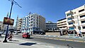
 -
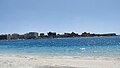
 Thecorniche
 -
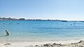
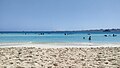
 City beaches
 -
 Rommel Beach
 -
 El Gharam Beach ( "Love Beach" ) (1)
 -
 El Gharam Beach ( "Love Beach" ) (2)
 -
 Al-Awam mosque
 -
 Governorate building


See also
editReferences
edit- ^abc"Marsā Maṭrūḥ (Kism (urban and rural parts), Egypt) - Population Statistics, Charts, Map and Location".citypopulation.de.Retrieved17 June2023.
- ^Dictionary of Greek and Roman Geography (1854), Paraetonium
- ^Strabo, Geography, 17.1
- ^George of Cyprus (1890).Georgii Cyprii Descriptio orbis romani.Cornell University: B. G. Teubneri. p. 142.
- ^"ToposText".topostext.org.Retrieved2019-12-30.
- ^Goodchild, R. G. (1991)."A Byzantine Chapel at Marsa Matruh (Paraitonium)".Journal of the American Research Center in Egypt.28:201–211.doi:10.2307/40000580.ISSN0065-9991.JSTOR40000580.
- ^Raza, Moonis (1990).Geographical Dictionary Of The World In The Early 20th Century With Pronouncing Gazetteer (in 2 Vos.).Concept Publishing Company.ISBN978-81-7268-011-4.
- ^Playfair, Vol. I, page 3.
- ^"Mersa Matruh Airport Normals 1991–2020".World Meteorological Organization Climatological Standard Normals (1991–2020).National Oceanic and Atmospheric Administration. Archived fromthe originalon 3 October 2023.Retrieved3 October2023.
- ^"Mersa Matruh (A) Normals 1961–1990".National Oceanic and Atmospheric Administration. Archived fromthe originalon October 3, 2023.RetrievedOctober 3,2023.
- ^"Station Mersa Matruh"(in French). Meteo Climat.Retrieved3 October2023.
- ^"Marsa Matruh Climate and Weather Averages, Egypt".Weather to Travel.Retrieved13 July2013.
- Falling Rain Genomics, Inc."Geographical information on Marsa Matruh, Egypt".Retrieved2008-03-23.
External links
editSources
edit- Playfair, Major-General I.S.O.;Molony, Brigadier C.J.C.; with Flynn, Captain F.C. (R.N.) & Gleave, Group Captain T.P. (2009) [1st. pub.HMSO:1954].Butler, Sir James(ed.).The Mediterranean and Middle East, Volume I: The Early Successes Against Italy, to May 1941.History of the Second World War, United Kingdom Military Series. Uckfield, UK: Naval & Military Press.ISBN978-1-84574-065-8.