This articleneeds additional citations forverification.(July 2022) |
Newportis amarket townin the borough ofTelford and WrekininShropshire,England.It lies 7 miles (11 km) north-east ofTelfordtown centre, 12 miles (19 km) west ofStafford,and is near the Shropshire-Staffordshireborder. The 2001censusrecorded 10,814 people living in the town's parish, which rose to 11,387 by the 2011 census.[3]
| Newport | |
|---|---|
 Newport from Cheney Hill | |
 Coat of arms of Newport | |
 Newport Location withinShropshire | |
| Population | 11,387 (Newport parish) |
| Demonym | Novaportan[1] |
| OS grid reference | SJ745191 |
| •London | 148 miles (238 km)SE[2] |
| Civil parish |
|
| Unitary authority | |
| Ceremonial county | |
| Region | |
| Country | England |
| Sovereign state | United Kingdom |
| Post town | NEWPORT |
| Postcode district | TF10 |
| Dialling code | 01952 |
| Police | West Mercia |
| Fire | Shropshire |
| Ambulance | West Midlands |
| UK Parliament | |
| Website | Official website |
Toponym
editTheNormansplanned a new town calledNovus Burgusroughly on theAnglo-Saxonsettlement of Plesc.[4]The first market charter was granted byHenry I,and over time the name changed from Novus Burgus, toNova Porta,toNewboroughand finally to Newport in about 1220.

Location
editThe site was chosen partly because of its location near theVia Devana(Roman Road,which ran fromColchestertoChester), and partly because of the number offisheries(which are mentioned in theDomesday Survey). TheRiver Meese,which flows fromAqualate Mere,lies to the north of the town.
Newport sits on asandstoneridge on the eastern border of theWelsh Marchesand west of theAqualate Mere,the largest natural lake in the English Midlands.[5]The area around it at the end of thelast ice agewas part ofLake Lapworth.Formed from meltingglaciers,it covered a vast area ofnorth Shropshire.There is evidence of pre-historic fishing in the area as two ancientlog boatswere uncovered one mile (1.6 km) from Newport. One has been preserved and is kept atHarper Adams UniversityatEdgmond.
The villages ofChurch Aston,ChetwyndandLongfordare adjoined to the south of Newport, though they remain in separateparishes.The village ofEdgmondis located just to the west, separated by Cheney Hill,Chetwynd Parkand the currently truncatedShrewsbury and Newport Canal.
Like many rural market towns, Newport was influenced byindustry;it served the needs of theminingarea to the east of Shropshire and was also affected bymass-producedindustrial goods that replaced traditionalcrafts.

Newport's inland location can lead to very cold winters. It holds the record for thelowest temperature recorded in England,−26.1 °C (−15.0 °F) on 11 January 1982.[6]This was cold enough to freeze diesel fuel in vehicles.[citation needed]
History
editNewport was located in thehistoric kingdomofMercia,near whereWreocensætewas once situated. Humans inhabited the surrounding area long before the creation of the town. Once established, Newport became amarket townin the centre of theruralfarmingarea betweenStaffordandShrewsbury.

Saxon period
editInSaxontimes, there were two settlements in the area. The first,Eastun,has been identified asChurch Aston,and the second wasPlaescwhich is now Newport.[7]In AD 963, Plaesc was described as having a High Street, a stone quarry, and a religious community. The name Plaesc means a shallow pool.[8]Few signs of the Saxon settlement exist today, apart from the High Street, the Quarry, which could be either the Quarry on Stafford Road, or the Hole Meadow on Wellington Road. This has not been definitely confirmed.[9]
Norman to Tudor period
editAt the time of theNorman Conquest,the land where Newport sits formed part of the manor ofEdgmond,whichWilliam Igave as a gift along with the county ofShropshiretoRoger, Earl of Shrewsbury.Henry Ifounded the borough, first called Newborough, after the manor came into his hands fromRobert de Belesme.
Newport was omitted from theDomesday Bookof 1086, but this is not uncommon. Other towns omitted include London,TamworthandLudlow,all boroughs since Saxon times.[citation needed]
The Normans planned the new town around the older one during the reign ofHenry I.The wide main street was designed for itsmarket,and the narrowburgage plotsrunning at right angles to it are typical ofNorman architectureand planning, though today onlyNewport Guildhalland Smallwood Lodge are clear signs of Tudor buildings, due to the 1665 fire which destroyed most of the High Street.[10]
Medieval Newport flourished with trade inleather,woolandfish.Novoportans possessed the right to provide fish for the Royal table. The manyhalf-timberedbuildings surviving from thelate medievalandTudor periodsconfirm Newport's success, leading to the first market charter which was granted by Henry I.
The town is mentioned once byJohn Lelandin a list ofcastles,though now no visible remains of the castle exist; however, the most probable location for it would have been the traditional site of a manor house at Upper Bar, where there is a fragment of a square, broad moat, or on the higher ground along the Forton road, where the Castle House school stands. As regards the moat, nearly square, forming by measurement an area of 60 square yards, two sides have been filled with rubbish. Nothing is known about the occupants of the moated site. It could have pre-dated the town or, perhaps more likely, could have been the manor house of the Audleys, who were granted the manor in 1227. By 1421, the manor house was in ruins.
One of the main reasons for Newport's early wealth was the surrounding fisheries and the chief service of the burgesses, being that of taking fish to theRoyal courtwherever it might be. This custom was continued afterHenry IIIhad granted the borough, with the manor of Edgmond, to Henry de Audley; Henry's son James granted in the middle of the 13th century that the burgesses need not take the fish anywhere except within the county of Shropshire.
The burgesses received certain privileges from Henry I;Henry II,in an undated charter, granted them all the liberties, rights and customs that they had enjoyed in the time of Henry I, including a guild merchant, which is mentioned in thequo warrantorolls as one of theprivilegesclaimed by the burgesses. Confirmation charters were granted byEdward Iin 1287 andEdward IIin 1311, while the town was incorporated in 1551 byEdward VI,whose charter was confirmed byJames Iin 1604. The governing body consisted of aLord High Steward,deputy steward, two water-bailiffs and 28 burgesses, but the corporation was abolished by theMunicipal CorporationAct of 1883, and a Local Board was formed, which, under theLocal Government Act 1894,gave place to anurban districtcouncil.
Stuart to Regency period
editIn 1665, many buildings were damaged in the Great Fire of Newport,[11]and only a few of themedievalstructures remain. However, there remain many fineRegencyandGeorgianfrontages built on the site of the former Norman plots. This allows the main streets of Newport to be wider and less cluttered than those of the other towns of its age.

Local landed estates
edit
By the 19th century, Newport was surrounded by large estates that came right to the verge of the town, determining size and development. Thevivaryand open fields at Norbroom had gone making the town dependent on its rural hinterland. The few fields that remained were for hay or cattle, forming a small green belt. These estates exerted a powerful influence on the town, something obvious in the deference shown and respect paid to these landed families until at least theFirst World War.
Beginning in the southwest of the town was the largest estate, theLilleshall estateof theDuke of Sutherland.This dates from thedissolution of the monasteries,the lands of Lilleshall Abbey being purchased in 1539 by James Leveson ofWolverhampton.
The next estate is that in the south-east ofWoodcote Hall,a smaller one belonging to the Cotes family.
On the west between Lilleshall and the town was theLongford Estateof the Talbots,Earls of Shrewsbury,sold in 1789 to Ralph Leake ofWellingtonwho had made his fortune in theEast India Company.
North of the town is theChetwynd Park estateof thePigotts,bought in 1803 by Thomas Borrow of northDerbyshirewho changed his surname to Burton Borough.
TheAqualate Estateto the east lies mostly inStaffordshire.
20th century
editThe town was fortunate to avoid civilian casualties during theSecond World Warwhen onChristmas Eve1944, aV-1 flying bomblaunched from aHeinkel bomberand aimed atManchesterlanded in a field east of Newport, about 300 yards from the Newport toGnosallroad.[12]This bomb is now on display atRoyal Air Force Museum Cosford.[12]
The passenger service on therailway linebetween Stafford and Wellington was withdrawn in 1964 as a result of theBeeching Axe,and the line closed completely in 1967. The track was lifted in 1969, and the Newport end was subsequently redeveloped for housing.
In the 1960s to early 1970s, when the population of Newport was nearer 3000, over a third of the local workforce was employed at Serck Audco Valves, Greenwood Moore, Kwiz Feather Flights etc. All of this industry and large-scale employment has since gone - mostly during the late 1970s and early 1980s.[citation needed]
On 23 November 1981,an F1/T2 tornadowhich formed over the nearby civil parish ofChetwyndlater moved over Newport, causing some damage in the town.[13]
AtHarper Adams University Collegejust outside Newport inEdgmond,on 11 January 1982 the English lowest temperature weather record was broken (and is kept to this day): −26.1 °C (−15.0 °F).[6]
Modern-day Newport
editNewport is now predominantly acommuter town,with people travelling to Telford, Shrewsbury, Stafford, Wolverhampton and beyond for employment.[citation needed]
Previously, very littleredevelopmenthappened in Newport from the 1960s—attention going instead to nearby towns includingWellingtonandOakengates,which make up thenew town of Telford—until theTelford and Wrekin Councilborough towns incentive was brought about in 2007. The town received major investments over the following years, including a major redevelopment of the canal and surrounding area, the lower bar of the High Street area, planned housing, bars and restaurants set to line thecanal.New sporting facilities, including aclimbing wallin the Springfield area of the town, were provided.
In the spring of 2010, the first stage of the town's £1.5million regeneration began, with the £250,000 and £300,000 redevelopment of Victoria Park behind the now-defunctThe Royal Victoria Hotel.[14]The next stage of the regeneration, which was mainly focused on theHigh Streetarea of the town and Central square, involved re-surfacing the High-Street pavements and changing the design of the High Street around thePuleston Cross,removing the cobblestones and replacing them with paving and the traced outline of the ancient market hall.[15][16]
In July 2011, Telford and Wrekin Council unveiled plans for green land off theA518bypass. The proposals included hundreds of new homes, a new supermarket, a business park and improvements to Burton Borough School.[17]
House prices in the town are the highest in the TF postcode area (including the towns of Telford andMarket Drayton) and among the highest in the county.[18]
The town is currently attempting to acquireTransition TownsandFairtrade Townstatuses.[19][needs update]
Facilities and places of interest
edit
The High Street
editThe main street in Newport follows theNormandesign. This resulted in the distinctive long wideHigh Street,split into three parts, upper bar, lower bar and St Mary's street, with the centre of the high street being the 19th-centuryTown Halland Market Hall completed in March 1860.[20]
Burgage plots ran along either side, and the church rising up in the middle, with the High Street with St Mary's Street splitting off and re-joining the high street around the island on which are sited theSt Nicholas Churchand the Puleston Cross (an ancient memorial cross usually known locally but inaccurately as the Butter Cross).

After the fire of Newport in 1665 the old Norman buildings were replaced with granderGeorgian architecture,which hid the work yards behind. The Georgian shops remain, but the work yards have now been developed into housing and the Boughey Gardens tennis courts, next to the literaryinstitute.
Newport has retained shops on High Street, Stafford Street and St Mary's Street, with St Mary's Street havingcobblestonesand the majority of shops being smallboutiques.St Mary's is also the site of various markets and fairs which tie in with Newport's indoor market.
The town also has businesses such asCosta Coffee,Boots,Card Factory,Subway,Greggs,Coral,Bet365,the town's formerWoolworthsstore was developed into aB&M Bargains.[21]

On the Newport by-pass near to theAqualate MeretheA518 roadthere is a small out-of-town industrial estate known as Mere Park, featuring a garden centre, hotel and restaurant. There are also various other small-scale industrial estates that lie around the Newport by-pass and Springfield estate.
Other areas
editThe oldest man-made landmark in the town is thePuleston Crosswhich is abutter crosspositioned near the Church of St Nicholas. This is a 13th-century cross denoting a marketplace. The cross was set up in memory of Sir Roger de Pyvelesdon (i.e. 'de Puleston') who died in 1272, in Shropshire. This is confirmed in a deed signed by his sonSir Roger de Pulestonin 1285, which refers tothe cross set up for the soul of Roger de Pyvelesdon who died in 1272.[22]
Towards the top end of the town is theCombat Stresscentre, built in 1908 as theinfirmaryfor the NewportWorkhouse;it was subsequently developed as accommodation for elderly ladies until its closure in 1995. The home was purchased in 1996 and refurbished.
The town sits near theAqualate Mere,which is the largest natural lake in theEnglish Midlands.
-
 St Nicholas's Church & Newportwar memorial
 -
 Aqualate lodge toAqualate Hall
 -
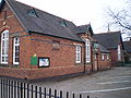 Newport junior school, built 1872


Religious sites
edit

The first recorded religious community was documented in Saxon script from 963 AD. This was the church of St Mary Magdalene, built in the time ofArchbishop Dunstan.
Newport lies in theChurch of EnglandDiocese of Lichfieldand theRoman Catholic Diocese of Shrewsburyand as a Norman-planned new town, religion played a strong part in the design of the town, with the centre of the town being dominated bySt Nicholas Church,originally built in the reign ofHenry Iand restored in 1886 and 1890.
The second church in the town is theSt Peter and PaulCatholicchurch in Newport Salters Lane, built 1857 and the oldestCatholic churchinShropshire,designed byAugustus Pugin.
The ruins ofLilleshall Abbeyare 4 miles (6.4 km) from the town centre. They include a Norman west door and part of the front, considerable remains of the church besides, and traces of domestic buildings. The abbey was founded in 1145, under charter fromKing Stephen,by Richard de Baumes or Belmeis, dean ofSt Alkmund,Shrewsbury, forAugustiniancanons,who were brought fromDorchester Abbey,Oxfordshire.
A smaller church for theBaptistcommunity sits at the back ofThe Royal Victoria Hotelin water lane, called Newport Baptist church, which was built in the 1960s.

The town has had a wide range of religious sites over time and this is shown in the number of churches in the town, the Independent Chapel, Beaumaris Lane, Newport, built 1803 on the site of a church dating from 1765, converted into cottages in 1832 when they finished work on the new church, the Newport Independent (Congregational) Chapel, Wellington Road, built in 1831, subsequently becoming part of the United Reformed Church. It merged with the Methodist Chapel in Avenue Road in 2001 to becomeTrinity Church,a joint Methodist/United Reformed Church. A major renovation was undertaken in 2010.
Due to the growth and decline of religions over time some previous churches have since been used for other uses or been demolished altogether, most of these are in the Upper Bar area of the town, around the Granville road and Wellington road area.
Near to the Trinity church is the Newport Primitive Methodist Chapel, built 1877, closed 1920 which replaced the one built in Stafford Road, built 1830. This is still there as a house next door to the New Inn.
Two more former churches are the Newport Wesleyan Methodist Chapel, Upper Bar, built 1829, which was turned into a shop and theatre in 1876 and the Wesleyan Methodist Chapel in Avenue Road which was built in 1876 and closed in 2001 on merging with the Wellington Road URC Chapel; it subsequently became a gym but has since been converted into a house.

Newport General Cemetery was opened for burials on 2 March 1859 with its first interment taking place on 5 March 1859 when it is noted that some 1,000 people witnessed the burial. The cemetery contains achapelbuilt at the same time and is bounded at the public roadside by fine wrought iron railings and gates. The cemetery was originally laid out with four oval lawns around a cross-shaped set of roads with the chapel centrally placed. The cemetery contains the war graves of eleven British Army soldiers ofWorld War Iand a soldier andairmanofWorld War II,who are commemorated by a row ofCommonwealth War Graves Commissionheadstones.[24][25]Also buried there is former first-class cricketerTom Collinswho was headmaster at Newport Grammar School.[26]
Economy
editNewport is the main hub for the farming community along the Shropshire/Staffordshire border and as a local business centre.The Football Association, Medical and Exercise Science Departmentis based atLilleshall Hallon the outskirts of the town.
A large section of Newport's economy is based around education, two selective state schools and a large comprehensive drawing students from far beyond the town, as well as a university on the edge of the town along with a regional food academy.
Retail plays a major part of the economy of the town, with the majority of shops being located in and around the High Street, with larger out-of-town stores located on the Audley Avenue and Springfield trading estates in the south of the town and to the east of the town the Mere Park complex.
Culture
editEvents and venues
edit

Cosy Hall is used for the Newport music festival.[27]
TheNewport Guildhallis a medieval timber-framed building which dates back to around 1400.[28]
Town events
edit
The town hosts many events throughout the year, but six main events bring people to Newport.Newport Showis hosted yearly at Chetwynd Deer Park and is the major annual event in the town, first held in Victoria Park in 1890 and now attracting 13,000 visitors each year. The show is now held at Chetwynd Deer Park betweenEdgmondand Newport.
In the centre of town itself the main events are the Newport Carnival and the Newport Old Tyme Market.[29]The biggest event in the town is the biennialNewport NocturneBike Race.[30]
Heart of England in Bloom
editIn 2009 Newport became the first town in the country to win six gold awards in a row in the Heart of England in Bloom regional competition of theBritain in Bloomcontest.[31]The 2010 competition gave Newport its seventh consecutive gold medal.[32]
Media
editThe town is covered by a local community radio station called NOVA FM, which broadcasts from the high street on 97.5FM, and by regional stations Signal 107, (formerly Telford FM),Free Radio Black Country & Shropshire,(formerly Beacon Radio), andBBC Radio Shropshire.
Local news and television programmes are provided byBBC West MidlandsandITV Central.Television signals are received fromThe WrekinTV transmitter.[33]
TheNewport and Market Drayton Advertiser,is the town's weekly newspaper, in publication since 1854, has premises located on St Mary's Street. The town is also covered by the county-wideShropshire StarandThe Shropshire Magazine.All are published by Shropshire Newspapers Ltd. Nova Magazine, first published in 1994 as Nova News, is a free monthly magazine distributed to Newport,Church Aston,Edgmond,Tibberton,Hinstock,Forton,Sutton,Norbury,Gnosall,Outwoods, Moreton,Sheriffhales,MuxtonandLilleshall.
In the media
editChristmas Guisers' Play from Newport, Shropshire [1883] is about the town. Newport was the first town in Shropshire to be onDickinson's Real Deal.[citation needed]A television documentary calledThe Spy Who Stole My Lifeshowed the town as the backdrop of theRobert Hendy-Freegardstory,[34]who conned students from the town[35]was shown byChannel Fiveon 7 September 2005. In Australia, this was calledThe spy Who Conned Me.[36]
Education
edit
Newport has a full range of educational establishments, from primary schools to a university. The selective schools in the town areNewport Girls' High SchoolandHaberdashers' Adams(previously known as Adams' Grammar School).Harper Adams Universityis located in the nearby village ofEdgmond,andKeele Universityoperates teaching rooms in the doctor'ssurgeryfor trainee student doctors. For Further Education students, the closest colleges to the town areTelford College of Arts and TechnologyandStafford College,with buses running from the town to both colleges and to Shrewsbury College of Arts & Technology. Just outside the town is Edgmond Hall, used bySandwell Metropolitan Borough Councilfor outdoor activities for school students.
| Infant | Church Aston Infant School·Moorfield Primary School·St Peter & St Paul RC Primary School·Newport Infant School |
| Junior | Newport Junior School·Moorfield Junior School. Castle House School |
| Comprehensive | Burton Borough School |
| Secondary state grammar schools (withsixth form) | Newport Girls' High School&Haberdashers' Adams |
| Universities | Harper Adams University |
Transport
editThe town has been a well-used crossing point even before the creation of the settlement and sits on a historical crossing of theVia Devana.
The town became prominent as a coaching town on theMail coachroute between London,North Walesand Ireland as well being on a historic junction on the road from London toChesterand theEast Midlands.This meant that the town grew around the different roads that cross the town. At the centre of the town is a large island with the church of St. Nicholas at one end and Central Square nightclub at the other, the High Street on one side and St Mary's Street on the other side. The two streets come together at one end in front of the nightclub at the junction with theA518from Stafford which runs through the town on an east–west route from Stafford to Telford. They come together at the other end by the truncatedShrewsbury and Newport Canalbeyond which is the junction with theA519 roadfromEccleshalland Stoke-on-Trent. At the southern end of the High Street is another junction where theA519 roadleaves on its way to Telford.
Before the road network, the canal was the main link to the town. It is not currently connected to the national network, but there are plans to restore it to a fully working canal by theShrewsbury and Newport Canals Trust.linking into the national canal network atNorbury Junctionto the east of theA41which now borders the town to the east on a north–southby-passroute opened in early 1985 to ease the congestion on the High Street.
The town sits around 9 miles (14 km) from theM54,and 11 miles (18 km) from theM6Motorways.
Buses
edit
The town is served by buses between Stafford and Telford and a service from Shrewsbury.Arriva Midlandsis the main service provider for the town with additional shoppers services operated by Wrekin Rider, the bus operating arm of Telford and Wrekin District Council.
Rail
editThe formerStafford to Shrewsbury Lineonce ran through the town, but due to cutsNewport (Salop) railway stationwas closed in September 1964 and has now been dismantled. The line has been restored to Hortonwood, and it is possible that the next phase could be to reconnect the town to the railway network. This has been given a boost by the town council, who are currently in talks withStafford Borough Councilto discuss the link to Stafford. The line is in the top 36 'Lines that should reopen' listing published by theCampaign for Better Transport,[37]and with theTelford International Freight Parkin Donnington, Telford needing better connections to the east coast and Scotland, this could mean a line going past the town and on towardsGnosalland Stafford.[38]
Cycling
editNewport is onNational Route55and Regional Route 75 of the Sustrans National Cycle Network. Cycle maps for these routes are available from the Newport Visitor Information centre, located in the Pop Up Shop on Wellington Road. The cycleway to Stafford runs on the former railway line and will be completed by the end of 2014.[39]
Walking
editThe town sits on theWay for the Millenniumwalkway which is 40 miles (64 km) long, and heads toward Stafford, passing through several villages on the way.
Sport and clubs
editNewport Town FC play in theWest Midlands (Regional) League(Division Two)[40]and have a reserve side ( "Edgmond Rangers" ) who play in theMercian Regional Football League(Division Two). Newport Town were the league champions of theShropshire County Premier Football Leaguefor the 2011–12 season, earning them promotion. Since promotion in 2012, the senior team now plays its home games atHarper Adams University Collegein Edgmond[40]and the reserve team also play in Edgmond. Previously they played their home games at Shuker Field, a 3-acre (1.2 ha) field close to theBurton Borough Schoolin Newport itself.
The NewportCrown Green Bowlsclub plays in the Premier Division of Shropshire after promotion from the Mid Shropshire division one as well as many other division and leagues.

Newport (Salop) Rugby Union Football Clubis the highest-ranked rugby club in Shropshire,[citation needed]and the main club in the town

NewportCricketClub plays in theShropshire Premier Cricket LeaguePremier Division.
On 2009, the £200,000Newport Sk8park was formally opened byPrincess Anne.Theskateparkis the largest in Shropshire and the largest W/ramp in Britain.[citation needed]
265(Chetwynd)Air Training Corpsare also based just outside of Newport, on the Chetwynd Deer Park.
Lilleshall Sports Centre
editLilleshall Hall- formerly the country retreat and hunting lodge for theDuke of Sutherland,situated just 2 miles (3.2 km) from the centre of Newport and is now home to Lilleshall National Sports Centre.
Notable residents
editEarly times
edit- Robert Puleston,(born in Newport) – brother-in-law and supporter ofOwain Glyndŵr,againstKing Henry IV
- Richard Barnfield(1574 inNorbury, Staffordshire– 1620) – English poet,[41]obscure though close relationship withWilliam Shakespeare,brought up in Edgmond nearby.
- William Adams,(1585 in Newport – 1661) – London Haberdasher foundedHaberdashers' Adamsin 1656
- Thomas Brown(1662 in Newport orShifnal– 1704) – satirist[42][43]
1750–1900
edit
- John Meeson Parsons(1798 in Newport – 1870) – art collector[44]and director of theShropshire Union Railway
- William Ick(1800 in Newport – 1844) English botanist and geologist
- James Brown(1812–1881) –Roman Catholic Bishop of Shrewsburyfrom 1851 to 1881, lived Salter's Hall, near Newport
- Arabella Elizabeth Roupell(1817 in Newport – 1914) – English flower painter
- James Hain Friswell(1825 in Newport – 1878) – English essayist[45]and novelist
- Charles Cecil Cotes(1846 Woodcote Hall – 1898) – British landowner and Liberal politician
- Colonel the Rt. Hon. William Slaney Kenyon-Slaney(1847–1908) – sportsman, soldier and MP forNewport1886 to 1908
- Percy John Heawood(1861 in Newport – 1955) – British mathematician
- James Edward Quibell,(1867 in Newport – 1935) –Egyptologist
- Frederick Phillips Raynham(1893–1954) – office worker at Harper Adams College and pilot from the early days of aviation
From 1900
edit
- Sir Peter James Bottomley(born 1944 in Newport) – British Conservative MP forWorthing Westsince 1997
- Ozzy Osbourne(born 1948) -Heavy metalrock singer, owned a bar in St Mary's Street in the late 1970s, run by his then wife Thelma, before selling it two years later. After a closure in 2013 it was revived under name ofOzzy's Sports Barin his honour.[46]
- Jeremy Corbyn,(born 1949) – Labour MP forIslington Northsince 1983, Leader of the Labour Party from 2015 to 2020. Lived as child inPave Laneand attendedCastle House SchoolandHaberdashers' Adams
- Peter Butler(born 1951 in Newport) – British Conservative MP forNorth East Milton Keynesfrom 1992 to 1997
- M. J. Bassett(born c. 1965 in Newport) – is an English screenwriter and film director ofSolomon Kane
- Michael Beasley(born 1968) - assistant curate at St Nicholas' Church in 1999-2003, laterBishop of Bath and Wells.[47]
- Robert Hendy-Freegard,(born 1971) – barman in Newport,conman,impostorwho masqueraded as anMI5agent[48]
- Craig Phillips,(born 1971) – winner ofBig Brother2000lived in Newport[49]
- Stuart Meeson(born 1972 in Newport) – physicist inElectrical Impedance Tomography,went to school in Newport
- James Sutton(born 1983) – is an English actor, best known for playingJohn Paul McQueeninHollyoaks.Lived in Newport[50]
Sport
edit- Thomas Collins(1841 – 1934 in Newport) – played first-class cricket for Cambridge University from 1861 and 1863 and was headmaster of Newport Grammar School from 1871 to in 1903
- Herbert Denis Edleston Elliott(1887 in Newport – 1973) – English cricketer, played forEssex County Cricket Club
- Reuben (Ben) Jones(1932 in Newport – 1990) – an Olympic equestrian, competed in the1964 Summer Olympics
- Paul Bracewell,(born 1962) – footballer forEngland,Newcastle UnitedandSunderland
- Adam Proudlock,(born 1981) – youth team coach for Newport Town, played forWolves,Ipswich TownandNottingham Forest
- David Pallett(born 1990 in Newport) – English darts player forProfessional Darts Corporation,lives in Newport
- Callum Burton(born 1996 in Newport) – English football goalkeeper forShrewsbury Town F.C.
- Ben Rowlings(born 1996) – British Paralympic athlete who competes in theT34 classification,lives in Newport
Surrounding villages and hamlets
edit
The town is surrounded by many different small villages, ranging from the larger settlements ofEdgmondandLilleshallto smallerhamletsall of which are joined to the town or separated only by a small distance. Most of these settlements are seen as parts of the town's catchment zone. Due to Newport's proximity to the county border, a number include Newport in their postal address, despite being situated in Staffordshire.
The following villages and settlements can be found near Newport:
- Church Aston
- Chetwynd
- Longford
- Edgmond
- Moreton, Staffordshire
- Meretown
- Adeney
- Stockton,Shropshire
- Pave Lane
- Bromstead Heath(Staffordshire)
- Great Chatwell(Staffordshire)
- Gnosall(Staffordshire)
- Forton,(Staffordshire)
- Coley(Staffordshire)
- Outwoods(Staffordshire)
- Wilbrighton(Staffordshire)
- Tibberton
Closest cities, towns and villages
editSee also
editReferences
edit- ^Neal, Toby (17 June 2017)."Has Linda disproved a town's Dickens of a legend?".Shropshire Star.Retrieved5 November2017.
- ^"Shrewsbury: the Town".SevernVale.co.uk. Archived fromthe originalon 20 December 2005.Retrieved24 February2008.
- ^"Area: Newport (parish)".Office for National Statistics.ONS. 30 January 2013.Retrieved26 May2016.
- ^'The Saxon Boundary of Newport',Newport History Society suggested map p.7 (2008)
- ^"Staffordshire's National Nature Reserves".GOV.UK.
- ^abGrintzevitch, Sarah (20 September 2010)."Wild Weather: Shropshire's record-breaking winter".BBC News.Retrieved26 May2016.
- ^Newport History Society, 'The Saxon Boundary of Newport' (2008) and Newport History Society, 'The History of Church Aston Boundary'(2007)'
- ^Newport History Society, 'The Saxon Boundary of Newport' (2008) p.15
- ^Newport History Society, 'The Saxon Boundary of Newport' (2008)p11-12
- ^Prentice 1986,p. 36.
- ^Ayto, John; Crofton, Ian (2005).Brewer's Britain & Ireland.London: Weidenfeld & Nicolson. p. 804.ISBN0-304-35385-X.
- ^ab"The bomb that nearly destroyed Newport".BBC:Shropshire:History:20th Century.November 2005.Retrieved20 January2013.
- ^"European Severe Weather Database".
- ^"Newport tourism plans « Shropshire Star".
- ^"Newport High Street revamp commenced | Wellington News".Archived fromthe originalon 1 October 2013.
- ^"Newport's old market unearthed during paving works".shropshirestar.27 September 2010.
- ^"Revealed: Massive plans for Newport » Newport Advertiser".Archived fromthe originalon 3 October 2011.Retrieved1 July2011.Newport Advertiser - Revealed: massive plans for Newport
- ^"New homes boosting Shropshire property sales".shropshirestar.12 August 2010.
- ^"Log In or Sign Up to View".facebook.
- ^Historic England."Former Town Hall (1367292)".National Heritage List for England.Retrieved21 August2023.
- ^"Shropshire star".
- ^Mrs Sunter Harrison of Wrexham - 'The Early Pulestons', Book Two, p.2 (pub. 1975, printed by Herald Printers, Whitchurch, Shropshire)
- ^Plaque commemorating opening of school is on front wall. Plaque commemorating Infants' annexe is 1898.
- ^[1][permanent dead link]Shropshire Virtual War Memorial, compiled by Neil Evans.
- ^CWGC."Newport Cemetery, Shropshire".CWGC.Retrieved10 January2024.
- ^"The Late Mr Tom Collins. A Striking Personality. Oldest Cricket Blue dies at 93. Former Headmaster of Newport".Shrewsbury Chronicle.23 March 1934. p. 11.
- ^"Newport Music Festival".1 November 2007. Archived fromthe originalon 1 November 2007.
- ^Historic England."Guildhall, Newport (1177807)".National Heritage List for England.Retrieved26 August2019.
- ^"Annual Old Tyme Market".
- ^"Newport Nocturne floodlit cycling race set to return".Shropshire Star.18 April 2014.Retrieved28 May2016.
- ^"Newport strikes gold, again!".Newport Advertiser.4 September 2009. Archived fromthe originalon 14 July 2011.Retrieved4 September2009.
- ^"Shropshire villages are proud of Heart of England in Bloom success".Shropshire Star.17 September 2010.Retrieved25 October2021.
- ^"Full Freeview on the The[sic] Wrekin (Telford and Wrekin, England) transmitter".UK Free TV.1 May 2004.Retrieved25 September2023.
- ^"Bogus spy in £1m con given life".The Birmingham Post.7 September 2005.Retrieved26 May2016.
- ^"Victims in fear as M15 conman is cleared".London Standard.25 April 2007.Retrieved26 May2016.
- ^"The Spy Who Conned Me (2005)".BFI.British Film Institute. Archived fromthe originalon 15 August 2016.Retrieved26 May2016.
- ^"Lines that should reopen - Top 36 | Campaign for Better Transport".2 August 2009. Archived fromthe originalon 2 August 2009.
- ^"Plan unveiled to restore Telford to Stafford rail line".Shropshire Star.29 March 2011.Retrieved29 May2011.
- ^"Work begins to complete cycle route".BBC News.14 September 2014.
- ^abFull Time FANewport Town
- ^.Encyclopædia Britannica.Vol. 03 (11th ed.). 1911.
- ^.Encyclopædia Britannica.Vol. 04 (11th ed.). 1911.
- ^"BBC Shropshire - places - Newport Town guide".BBC Home.BBC. 21 July 2008.Retrieved14 June2016.
- ^Lee, Sidney,ed. (1895)..Dictionary of National Biography.Vol. 43. London: Smith, Elder & Co.
- ^Stephen, Leslie,ed. (1889)..Dictionary of National Biography.Vol. 20. London: Smith, Elder & Co.
- ^"Bar's name reveals its links to legendary Midlands rocker".Shropshire Star.16 December 2022. p. 28.Report by Sunil Midda. Part of series "Love Your Local" on Shropshire pubs.
- ^"Bishop of Bath and Wells: 28 April 2022".GOV.UK.Prime Minister's Office, 10 Downing Street. 28 April 2022.Retrieved28 April2022.
- ^"'MI5 agent' conman jailed for life ".The Guardian.6 September 2005.Retrieved26 May2016.
- ^"Big Brother winner Craig Phillips keeps it real with £6.9 million fortune".Shropshire Star.11 September 2014.Retrieved27 May2016.
- ^[2]Shropshire Life Magazine
Bibliography
edit- Prentice, Rob.A history of Newport.Chichester, Sussex, UK: Phillimore, 1980.ISBN0 85033 568 X.