You can helpexpand this article with text translated fromthe corresponding articlein Vietnamese.(October 2023)Click [show] for important translation instructions.
|
Nha Trang(English:/ˌnjɑːˈtræŋ/or/ˌnɑːˈtræŋ/;Vietnamese:[ɲaː˧ʈaːŋ˧]ⓘ) is a coastal city and capital ofKhánh Hòa Province,on theSouth Central Coastof Vietnam. It is bounded on the north byNinh Hoàtown, on the south byCam Ranhcity and on the west byDiên Khánh District.The city had a population of about 535,000 people in 2023.[2]An area of 12.87 km2(4.97 sq mi) of the westerncommunesof Diên An and Diên Toàn is planned to be merged into Nha Trang which will make its new area 265.47 km2(102.50 sq mi) based on the approval of thePrime Minister of Vietnamin September 2012.
Nha Trang | |
|---|---|
| Nha Trang City Thành phố Nha Trang | |
Skyline alongside Nha Trang Beach Nha Trang Bay | |
 Seal | |
 | |
 Nha Trang Location in Vietnam  Nha Trang Nha Trang (Southeast Asia)  Nha Trang Nha Trang (Asia) | |
| Coordinates:12°14′42″N109°11′30″E/ 12.24500°N 109.19167°E | |
| Country | |
| Region | South Central Coast |
| Province | Khánh Hòa |
| Founded | 1977 |
| Government | |
| • People's Committee President | Lê Hữu Thọ |
| • People's Committee Vice President 1 | Nguyễn Anh Tuấn |
| • People's Committee Vice President 2 | Lê Huy Toàn |
| • People's Committee Vice President 3 | Nguyễn Khắc Hà |
| Area | |
| 254.29 km2(98.18 sq mi) | |
| Population (2023) | |
| 579,000 | |
| • Density | 2,300/km2(5,900/sq mi) |
| •Urban | 407,000 |
| • Ethnicities | |
| Metro GDP (PPP, constant 2015 values) | |
| • Year | 2023 |
| • Total | $3.9 billion[1] |
| • Per capita | $11,500 |
| Time zone | GMT + 7 |
| ZIP code | 625080 |
| Climate | As |
| Website | nhatrang |


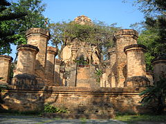
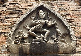
Historically, the city was known asKautharaunder rule of theKingdom of Champa.The city is still home to the famousPo NagarTowers built by the Champa. Being a coastal city, Nha Trang is a center formarine sciencebased at theNha Trang Oceanography Institute.TheHon Munmarine protected area is one of four firstmarine protected areasin the world admitted by theIUCN.
Nha Trang is well known for its beaches andscuba divingand has developed into a popular destination for international tourists, attracting large numbers ofbackpackers,as well as more affluent travelers on the south-east Asia circuit; it is already very popular with Vietnamese tourists, with Nha Trang Bay widely considered as among the world's most beautiful bays.[citation needed]Tourists are welcomed to participate in the Sea Festival, held biennially.
Etymology
edit
According to some researchers, the nameNha Trangderives from a Vietnamese spelling of theCham languagename of the siteEa Dran(literally "Reed River" ), the name of the Cai River as referred to by theCham people.From the name of this river, the name was adopted to call what is now Nha Trang, which was officially made Vietnam's territory in 1698. Ea Dran is a common Cham and Montagnard place name, same asIa Drang Valley.
As far as the recorded naming ofNha Trangis concerned, inToàn tập Thiên Nam Tứ Chí Lộ Đồ Thư,a geographical book written by a Vietnamese scholar with the family of Đỗ Bá in the second half of the 18th century, the nameNha Trang Môn( "Nha Trang gate" ) was mentioned.[3]In another map dating to the 17th century, known asGiáp Ngọ Niên Bình Nam Đồby a noble called Đoan Quận công Bùi Thế Đạt, the nameNha Trang Hải môn(Nha Trang Sea Gate) was also cited.[3]In Vietnamese recorded historic bibliographies, these books are perhaps the earliest ones that mentioned this place name.
In a work byLê Quý ĐôncalledPhủ biên tạp lục(1776), many Nha Trang-related names were mentioned, such asđầm Nha Trang, dinh Nha Trang, nguồn Nha Trang, and đèo Nha Trang.
History
editKauthara, also translated as an ancient clam, is a constituent state of the empire-leading kingdom and its ruling area is located in the area from today's Fu A province to Cam Ranh. Yanpunagara, the capital of Yangpu, occupies the faith of a man and is deeply influenced by religions such as Hinduism and Buddhism. However, in addition to that, the gods who formerly occupied ruled the indigenous faith in the motherland, such as Çri Maladakuthara ( thích lợi ma lạc đà cổ đát la ) in the ancient Gur'an region in the south, are one of those who can preserve the old God Most of the old gods who dominated the motherland were replaced by brahmanist gods such as the goddess Yan Pu Nagara ( dương phổ kia kiệt la )[4]and the Bhagavati ( thê bà già bà đế ), Replaced, located in Nha Trang near today. Bhagavati is mixed with Yan Pu Nagara, a goddess in the local faith, which is quite revered by the people and has dedicated ancestral temples to enshrine it.[5]
From 1653 to the 19th century, Nha Trang was a deserted area rich in wildlife (animals liketigers) and was a part of Hà Bạc, Vĩnh Xương County, Diên Khánh Province. After just two decades in the early 20th century, Nha Trang underwent a rapid change. On August 30, 1924, theGovernor-General of French Indochinadecreed Nha Trang as a townlet (urban centre).[6]Nha Trang Townlet was established from the ancient villages of Xương Huân, Phương Câu, Vạn Thạnh, Phương Sài, and Phước Hải.

DuringFrench Indochina,Nha Trang was seen asde factocapital ofKhánh Hòa Province.The colonial administration offices (like Envoy Office, Commanding Office, Trade Office, Post Office) were situated in Nha Trang. Local royal offices like Province Chief, Provincial Judge, Military Commander are inDiên Khánhcity (a walled military city 10 km south-west of Nha Trang).
On 7 May 1937, theGovernor-General of French Indochinaby another decree upgraded Nha Trang Townlet to town.[7]At this time, Nha Trang Town had five wards based on the ancient villages merged to make the town: Xương Huân, Phương Câu, Vạn Thạnh, Phương Sài, and Phước Hải.
On 27 January 1958, the president of theRepublic of Vietnam,Ngô Đình Diệmby Decree 18-BNV abrogated the town status of Nha Trang and divided Nha Trang into two rural communes: Nha Trang Đông (Eastern Nha Trang) and Nha Trang Tây (Western Nha Trang), under the administration of Vĩnh Xương County.
During the late 1960s, the U.S. Army's First Field Force, Vietnam (1FFV) was headquartered in Nha Trang. 1FFV was a corps-level major subordinate command of the U.S. Army Military Assistance Command, Vietnam (MACV).
On 22 October 1970, the government of the Republic of Vietnam by Decree 132-SL/NV reestablished Nha Trang Town on the ground of Nha Trang Đông and Nha Trang Tây and other rural communes. Following that establishment, the government by Decree 357-ĐUHC/NC/NĐ dated 5 June 1971 divided Nha Trang into 11 urban zones.
On 2 April 1975, communist (Viet Cong/PRG/VPA) forces captured the city. On 4 April 1975,Khánh Hòa Military Commission(Ủy ban Quân quản Khánh Hòa) divided Nha Trang into three administrative districts: District 1, District 2 and Vĩnh Xương District. In September 1975, the districts were merged to become one entity, the town of Nha Trang.
On 30 March 1977, the Council of the Government (now the cabinet) of theSocialist Republic of Vietnamby Decision 391-CP/QĐ upgraded Nha Trang to city status, a county-level city under the administration ofPhú Khánh Province(a province created by merger of nowPhú Yên ProvinceandKhánh Hòa Province). Seven communes of former Vĩnh Xương County, namely Vĩnh Thái, Vĩnh Ngọc, Vĩnh Hiệp, Vĩnh Lương, Vĩnh Trung, Vĩnh Thạnh, Vĩnh Phương was split from Khánh Xương County to become Nha Trang City territory.
On 27 March 1978, the provincial government by Decision 54-BT founded Phước Đồng Commune under Nha Trang City.
On 1 July 1989, Khanh Hoa was split from Phu Khanh Province to becomeKhánh Hòa Provinceas it was before, Nha Trang was made the capital of Khánh Hòa Province. On April 22, 1999,Phan Văn Khảiby Decision 106/1999 recognized Nha Trang City as a second-class municipal city. On April 22, 2009, former Prime Minister Nguyễn Tấn Dũng recognized Nha Trang City as a first-class municipal city.
Geography
editNha Trang city has a metropolitan area of 251 km2(97 sq mi) and population of about 500,000. It bordersNinh Hòatown in the north,Cam Ranhcity in the south,Diên Khánhtown in the west and theEast Seato the east. The city is on the beautiful Nha Trang Bay, which was chosen byTravel + Leisurein two succeeding years as one of 29 most beautiful bays in the world. Nha Trang is surrounded on all three sides by mountains and a large island and four smaller ones on the fourth side (in the ocean directly in front of the city's main area), blocking major storms from potentially damaging the city.

Climate
editNha Trang has atropical savanna climate(Köppen climate classification:As), with a lengthy dry season from January to August and a shorter wet season from September to December, when 1,029 mm (41 in) of the city's total annual rainfall of about 1,300 mm (51 in) is received from the north-east monsoon.[8][9]During the wet season extremely heavy rainfall fromtyphoonsis not uncommon,[10]though the city is shielded from the worst winds.
| Climate data for Nha Trang | |||||||||||||
|---|---|---|---|---|---|---|---|---|---|---|---|---|---|
| Month | Jan | Feb | Mar | Apr | May | Jun | Jul | Aug | Sep | Oct | Nov | Dec | Year |
| Record high °C (°F) | 31.9 (89.4) |
33.3 (91.9) |
34.2 (93.6) |
35.9 (96.6) |
38.5 (101.3) |
39.5 (103.1) |
39.0 (102.2) |
39.5 (103.1) |
38.3 (100.9) |
34.8 (94.6) |
34.3 (93.7) |
32.8 (91.0) |
39.5 (103.1) |
| Mean daily maximum °C (°F) | 27.2 (81.0) |
28.0 (82.4) |
29.4 (84.9) |
31.1 (88.0) |
32.3 (90.1) |
32.7 (90.9) |
32.5 (90.5) |
32.6 (90.7) |
31.7 (89.1) |
30.0 (86.0) |
28.6 (83.5) |
27.3 (81.1) |
30.3 (86.5) |
| Daily mean °C (°F) | 24.0 (75.2) |
24.6 (76.3) |
25.8 (78.4) |
27.4 (81.3) |
28.6 (83.5) |
28.8 (83.8) |
28.5 (83.3) |
28.5 (83.3) |
27.8 (82.0) |
26.7 (80.1) |
25.8 (78.4) |
24.7 (76.5) |
26.8 (80.2) |
| Mean daily minimum °C (°F) | 21.4 (70.5) |
21.8 (71.2) |
23.0 (73.4) |
24.6 (76.3) |
25.5 (77.9) |
25.7 (78.3) |
25.6 (78.1) |
25.5 (77.9) |
24.9 (76.8) |
24.2 (75.6) |
23.5 (74.3) |
22.3 (72.1) |
24.0 (75.2) |
| Record low °C (°F) | 14.6 (58.3) |
14.6 (58.3) |
16.4 (61.5) |
19.4 (66.9) |
19.7 (67.5) |
19.8 (67.6) |
20.6 (69.1) |
21.5 (70.7) |
21.3 (70.3) |
18.8 (65.8) |
16.9 (62.4) |
15.1 (59.2) |
14.6 (58.3) |
| Average rainfall mm (inches) | 43.0 (1.69) |
16.1 (0.63) |
30.3 (1.19) |
41.8 (1.65) |
51.5 (2.03) |
49.8 (1.96) |
41.7 (1.64) |
81.7 (3.22) |
165.8 (6.53) |
312.3 (12.30) |
381.6 (15.02) |
191.4 (7.54) |
1,399.2 (55.09) |
| Average rainy days | 8.6 | 4.3 | 4.1 | 5.0 | 9.2 | 8.3 | 8.4 | 9.8 | 14.4 | 17.6 | 18.0 | 14.4 | 122.2 |
| Averagerelative humidity(%) | 78.1 | 78.7 | 79.6 | 80.4 | 78.8 | 77.2 | 76.9 | 77.2 | 80.0 | 82.6 | 81.8 | 79.7 | 79.3 |
| Mean monthlysunshine hours | 179.6 | 208.7 | 256.5 | 258.5 | 259.1 | 235.2 | 243.5 | 236.0 | 203.8 | 183.1 | 140.4 | 136.5 | 2,538.8 |
| Source 1: Vietnam Institute for Building Science and Technology[11] | |||||||||||||
| Source 2: The Yearbook of Indochina[12] | |||||||||||||
Administrative divisions
edit

Nha Trang is subdivided into 22 wards and communes, of which 14 are urban wards: Vĩnh Hải, Vĩnh Phước, Vĩnh Thọ, Vạn Thạnh, Phương Sơn, Ngọc Hiệp, Phước Hòa, Tân Tiến (founded in November 2024), Phước Hải, Lộc Thọ, Vĩnh Nguyên, Vĩnh Trường, Phước Long, Vĩnh Hòa; and 8 suburban communes: Vĩnh Phương, Vĩnh Trung, Vĩnh Thạnh, Vĩnh Thái, Vĩnh Hiệp, Vĩnh Ngọc, Vĩnh Lương, and Phước Đồng.
Since 1998, due to the high pace of urbanization, many urban planned zones have been built: Hòn Rớ, Bắc Việt, Thánh Gia, Đường Đệ, and Nam Hòn Khô.
Education
editNha Trang is home to themultidisciplinaryNha Trang University(formerly Nha Trang Fishery University); the Naval and Aviation Academy; a teachers' training college; Khanh Hoa University, as well as theNha Trang Oceanography Institutea unique institute of oceanography in Vietnam and thePasteur Institute of Nha Trang,one of the many famousPasteur Institutes.
Nha Trang Pasteur Institute
editThe French-Swiss bacteriologistAlexandre Yersin,discoverer of theYersinia pestisbacterium lived in Nha Trang for 50 years and was affectionately known asÔng Năm.He established the Indochinese Pasteur Institute (now known as thePasteur Institute of Nha Trang), devoted to researching thebubonic plague.Yersin died in Nha Trang on 1 March 1943. A street in the city is named after him, and a shrine has been built over his tomb. There is a Yersin Museum dedicated to his achievements.
Economy
editNha Trang's economy relies largely on tourism. In the suburban areas around the city, the shipbuilding industry has developed and contributed significantly to the local economy. Fishery and services are also important to the city. Khanh Hoa Province in general and Nha Trang is particular are among the largest contributors to Vietnam's annual budget revenues.Lobster farmingon the sea is an important industry for the people living in suburban areas.
To the south of the city, by Cam Ranh Bay, several industrial parks are under construction and have been partly available for investors. Once the construction of the deep-water port onVân Phong Bayhas been completed, this area will become the third important economic zone in the province (besides Nha Trang and Cam Ranh).

Tourism
edit


Nha Trang is one of the most important tourist hubs of Vietnam, thanks to its beaches with fine and clean sand and the clear ocean water with mild temperatures all year round. There are several resorts — such as Vinpearl, Diamond Bay and Ana Mandara — and amusement and water parks, in the city and on islands off the coast. The possibly most beautiful street of Nha Trang isTran Phu Streetalong the seaside, sometimes referred to as theNorth-South Expressway Eastof Vietnam.
Lying off Nha Trang is theHon Tre Island(Bamboo Island), with a major resort operated by the Vinpearl Group. TheVinpearl Cable Car,agondola liftsystem, links the mainland to the five-star resort and theme park on Hon Tre Island.
Nha Trang is a stopover for annual yacht races starting in Hong Kong. In recent years, the city has welcomed many five-star sea cruises. In addition to sailboat racing, Nha Trang provides a rich variety of tourist activities for visitors. Island hopping, scuba diving, water sports and other sporting activities can be enjoyed. The Nha Trang Tourist Information Center (a non-governmental organisation), located near theCho Dam Markethas been set up to provide information for visitors.[13]
The local cuisine is most famous for fresh seafood and barbecued pork rolled in rice paper. The area'sbird's nest soupis deemed one of the best in Vietnam. Bird's nests are collected in the wild, on bird farms on the islands off the coast and even in some houses in the inner city. The farmed bird in question belongs to theswiftletgroup, popularly referred to asyến hàng(Aerodramus fuciphagusandA. germani).
Tourist attractions
edit
Scuba diving and kite boarding are available, as are catamaran sailboats. Winds are steady.
- Alexandre Yersin Museum
- Pasteur Institute of Nha Trang
- Nha Trang Oceanography Institute,the largest of its kind inIndochinawhere thousands of oceanic life samples, exhibits are on display. It is home to the largest oceanic library in Vietnam.
- Chánh Tọa Church (or Mountain Church)
- Long Son Pagoda,and its statue ofGautama Buddha.
- Tong Lam Lo Son Pagoda, and its statue ofAmitabha Buddha.
- Magical Mystery Tour Nha Trang
- Boat tour on Cai River, visiting islands off the coast and Ba Hồ Waterfall
- Palace of EmperorBảo Đại
- Thap Ba Hot Spring (Lady Tower hot spring)
- Nha Phu Lagoon
- Hoa Lan Stream (Orchid Flower stream)
- Monkey Island
- Sạn Beach
- Hòn Tằm Island (Silkworm island)
- Hòn Mun Island (Ebony island)
- Hòn Con Sẻ Tre Island (Bamboo Sparrow island)
- Hòn Ông Island
- Đảo Yến Island (Swiftlet island)
- Hòn Tre Island (Bamboo island)
- Suối Đổ Stream
- Suối Tiên Stream (Fairy stream)
- Hòn Bà Mountain
- Cai River Minigolf & Restaurant & Marina
- Yangbay Waterfall
- Tháp Bà Pô Nagar Nha Trang (a Champa Tower)
- Chùa Long Sơn (Long Son Pagoda, literally "The Dragon Mountain Pagoda" — or White Buddha Pagoda)
- Trí Nguyên Aquarium (an aquarium where hundreds of rare oceanic species are fed)
- Vinpearl Cable Car
Culture
edit
Cuisine
editLocal culinary specialities that attract people arebánh canh chả cá(bánh canhwith fish cakes and fish broth),bún cá sứa(rice vermicelli with jelly fish) andbánh xèo mực(crepes with squid).
Transportation
editWhenCam Ranh Bayused to be an important naval base,Nha Trang Airportwas the main airport of the city. This airport was used by theUnited States Air Forceand Republic of Vietnam Air Force during theVietnam War.When part of Cam Ranh Bay was made an economic development zone by the Vietnamese government,Cam Ranh International Airport(also a military airport built by the United States during Vietnam War) was made the new civilian airport of the city. This airport is located by Cam Ranh Bay, 28 km (17 mi) south of the city and was (as of 2007) the fourth busiest airport in passenger traffic in Vietnam serving more than 683,000 passengers in 2008. As of 2016, the airport has domestic connections toHanoi,Hồ Chí Minh City,Hải Phòng,Đà Nẵng,Vinh.
The city is next to theNational Route 1,the backbone north–south road of the country. TheReunification Railwaycrosses the city and stops atNha Trang Railway Station.The construction work ofVân Phong Port,north of the city, a deep-water project capable of handling ships up to 100,000 tonnes, and with a capacity of 100 million tonnes of cargo per annum, is under progress by a consortium of Japanese corporations. The estimated investment capital for this port-city complex project is expected to reach US$15 billion.
Gallery
edit-
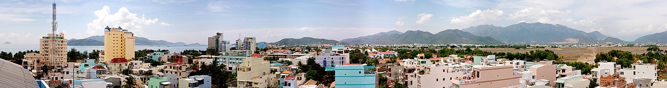 Nha Trang coastal city viewed from above
 -
 Nha Trang's skyline
 -
 Hon Chong rocks
 -
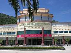 The official venue ofMiss Universe 2008pageant
 -
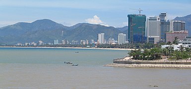
 Nha Trang Bay
 -
 Another view at Po Nagar temple
 -
 A Durga ornament
 -
 Long Son pagoda
 -
 A typical street in Nha Trang City
 -
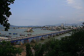 Xóm Bóng Bridges(1975–2022)
 -
 Oceanographic Institute
 -
 Another view
 -
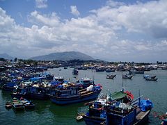 The fishing harbour
 -
 Sea anemone
 -
 The center of Nha Trang city
 -
 Street Nha Trang


Sister cities
edit Đà Lạt,Vietnam
- Thái Nguyên,Vietnam
 Kota Kinabalu,Malaysia
See also
editReferences
edit- ^"TelluBase—Viet Nam Fact Sheet"(PDF).Tellusant Public Service Series.Retrieved2024-07-31.
- ^"Thông tin dân số Thành phố Nha Trang mới nhất - ACC Khánh Hòa"(in Vietnamese). 2024-05-03.Retrieved2024-12-20.
- ^abHồng Đức bản đồ, bản dịch của Bửu Cầm và cộng sự, Viện Khảo cổ Sài Gòn xuất bản 1962.
- ^Mã tư bồi la 《 chiếm bà sử 》 chương 1 《 thổ địa cập nhân dân 》, Đài Loan thương vụ ấn thư quán trung bản dịch, 6 trang.
- ^Mã tư bồi la 《 chiếm bà sử 》 chương 1 《 thổ địa cập nhân dân 》, Đài Loan thương vụ ấn thư quán trung bản dịch, 4-5 trang.
- ^According to J.O.I.C page 1689, a copy from French version kept as archives Monographical Department of Khanh Hoa Province Library.
- ^According toOfficial Gazettenumber 9 of 1937 by the French colonial government, kept as an archive in Monographical Department of Khanh Hoa Library.
- ^Kottek, Markus; Grieser, Jürgen; Beck, Christoph; Rudolf, Bruno; Rubel, Franz (2006)."World Map of the Köppen-Geiger climate classification updated"(PDF).Meteorologische Zeitschrift.15(3):259–263.Bibcode:2006MetZe..15..259K.doi:10.1127/0941-2948/2006/0130.
- ^Peel, M. C.; Finlayson B. L. & McMahon, T. A. (2007)."Updated world map of the Köppen–Geiger climate classification"(PDF).Hydrol. Earth Syst. Sci.11(5):1633–1644.Bibcode:2007HESS...11.1633P.doi:10.5194/hess-11-1633-2007.ISSN1027-5606.
- ^SeeMore Variable Tropical Climates Have a Slower Demographic Growth
- ^"Vietnam Institute for Building Science and Technology"(PDF).
- ^The Yearbook of Indochina
- ^NhaTrang live info center