You can helpexpand this article with text translated fromthe corresponding articlein Finnish.(June 2023)Click [show] for important translation instructions.
|
Päijät-Häme[2](Finnish pronunciation:[ˈpæi̯j(ː)æt̪ˌhæme̞(ʔ)];Swedish:Päijänne-Tavastland) is aregioninSouthern Finlandsouth of the lakePäijänne.It borders the regions ofUusimaa,Kanta-Häme,Pirkanmaa,Central Finland,South SavoandKymenlaakso.The biggest city in the region isLahti.[3]
Päijät-Häme
Päijänne-Tavastland Päijänne Tavastia | |
|---|---|
| Region of Päijät-Häme Päijät-Hämeen maakunta(Finnish) Landskapet Päijänne-Tavastland(Swedish) | |
 Flag  Coat of arms | |
 Päijät-Häme on a map of Finland | |
| Country | Finland |
| Historical province | Tavastia |
| Capital | Lahti |
| Other towns | HeinolaandOrimattila |
| Area | |
| • Total | 6,256.66 km2(2,415.71 sq mi) |
| • Land | 5,126.11 km2(1,979.20 sq mi) |
| Population (2019) | |
| • Total | 199,604 |
| • Density | 32/km2(83/sq mi) |
| GDP | |
| • Total | €6.247 billion (2015) |
| • Per capita | €30,955 (2015) |
| ISO 3166 code | FI-16 |
| NUTS | 185 |
| Regional bird | White-backed woodpecker(Dendrocopos leucotos) |
| Regional fish | Carp bream(Abramis brama) |
| Regional flower | Cornflower(Centaurea cyanus) |
| Regional stone | Diabase |
| Regional lake | Lake Päijänne |
| Regional song | Vihreiden harjujen maa(The Land of the Green Ridges) |
| Website | paijat-hame.fi |
Päijät-Häme boasts a landscape shaped by two key features. Finland's second-largest,Lake Päijänne,dominates the region, offering a vastfreshwaterexpanse and a vitaltransportationroute. TheHäme Ridge,a glacial remnant, adds a touch of elevation and scenic variation. Beyond these, Päijät-Häme features extensiveconiferous forests.Rolling hills provide scenic views, while numerous smaller lakes and rivers create a network ofwaterways.[4]
History
editPäijät-Häme's landscape reflects the dramatic retreat ofglaciers.Thelast Ice Agecarved the land, leaving ridges (Salpausselkä) and large lakes (Finnish Lakeland). As the ice melted, theBaltic Seawent through various stages, dramatically changing shorelines. Land rose, creating islands and eventually dry land. Human settlement followed the receding water, with thePorvoo Rivervalley being the oldest cultural landscape. Today, Päijät-Häme boasts a unique blend of lakes, ridges, and reminders of its glacial past.[4]
After glaciers retreated 11,000 years ago, the first settlers arrived in Päijät-Häme. Birch dominated the initially barren landscape. As the climate warmed, people lived near ancient lakes and bays. By 5100 BC, theComb Ceramic culturethrived. The arrival of theBattle Axe culturearound 3200 BC brought new tools and pottery styles. During theBronze Age(1900 BC), cremation burials and large stone cairns became common. In theIron Age,settlements shifted to better farming areas near waterways.Vikingraids and unrest marked the later Iron Age. Christianity arrived during theCrusades(1050-1300 AD).[5]
By theMiddle Ages,villages dotted the shores of waterways and lakes. The 16th century saw a solidification of village life, with the most prominent settlements aroundHollola,Lahti,andNastola.The 1800s brought a boom in agriculture, with cultivated land tripling and industries like flax farming and cattle raising flourishing. Forests were mostly owned by farms, and improved transportation facilitated timber sales.Manor housesplayed a crucial role in rural life until World War I, with some later being divided into new farms. Today, Päijät-Häme's settlement can be divided into three zones: the sparsely populated eastern area with smaller farms and estates, the more densely populated central region with a strong presence of independent farms, and the sparsely populated north with vast forests. As transportation networks evolved, settlement patterns shifted, with Lahti emerging as the dominant population center.[6]
Villages in Päijät-Häme have a long history intertwined with the landscape. Most likely arose around the 16th century, strategically placed near ridges andwaterwaysfor easy access to water andfertile land.Water remained the primary mode of transportation for centuries, with some villages even shifting their centers to be closer tonavigableroutes. The arrival ofrailwaysin the 19th century revolutionized transportation, and later road networks further influenced development.Heinola,for example, benefitted from its location near the Kymijoki River, which facilitated industrial growth once railways arrived. This pattern likely mirrored itself across Päijät-Häme during the 1800s and 1900s.[7]
Heinola, founded in 1776, became the region's first city in 1839. Industrial areas grew around its center, particularly on the east and south sides. Lahti's story is tied to railways and lakeside industry. It gained market town rights in 1878 and city status in 1905. Factories likesawmills,apulp mill,andmatchfactories fueled Lahti's expansion. Village churches (kirkonkylät) also saw growth from the 1860s onward, spurred by relaxed land ownership laws. However, rapid expansion in some villages obscured their older features. Lahti housed sawmills, pulp mills,glassfactories, andtextileproducers. Heinola developed sawmills,plywood,andfiberboardfactories alongside metalworking. Notably,Hämeenkoskihad Finland's first flax cleaning plant built in 1888. Worker housing districts accompanied industrial growth. The passage mentions both early examples and later, larger developments from the post-war period and the 1960s and 70s.[8]
Historical provinces
editHeraldry
editBlazon: Azure, amermaidand in dexter chief acuckooclose Or. In laymen's terms: The coat of arms sports a depiction of the ancient water goddessVellamoas a mermaid, with a cuckoo.[9][10]
Municipalities
editThe region of Päijät-Häme consists of 10municipalities,two of which have city status (marked in bold).
Municipalities on the map
edit
Sub-regions
edit Kärkölä
 Lahti(Lahtis)
 Orimattila
 Padasjoki
 Sysmä
Sysmä
Municipalities listed
edit| Coat of arms |
Municipality | Population | Land area (km2) |
Density (/km2) |
Finnish speakers |
Swedish speakers |
Other speakers |
|---|---|---|---|---|---|---|---|
 |
Asikkala | 7,968 | 563 | 14 | 97 % | 0.2 % | 3 % |
 |
Hartola | 2,531 | 543 | 5 | 97 % | 0.1 % | 3 % |
 |
Heinola | 17,953 | 676 | 27 | 95 % | 0.2 % | 5 % |
 |
Hollola | 22,885 | 651 | 35 | 96 % | 0.3 % | 3 % |
 |
Iitti | 6,444 | 590 | 11 | 97 % | 0.2 % | 2 % |
 |
Kärkölä | 4,114 | 257 | 16 | 95 % | 0.5 % | 5 % |
 |
Lahti | 120,693 | 460 | 263 | 90 % | 0.4 % | 9 % |
 |
Orimattila | 15,669 | 785 | 20 | 96 % | 0.6 % | 4 % |
 |
Padasjoki | 2,726 | 523 | 5 | 97 % | 0.4 % | 3 % |
 |
Sysmä | 3,496 | 667 | 5 | 97 % | 0.3 % | 3 % |
| Total | 204,479 | 5,715 | 36 | 93 % | 0.4 % | 7 % |
Former municipalities
edit
 Artjärvi(Artsjö)
- Consolidated with the town ofOrimattilain 2011.[11]
 Hämeenkoski
 Heinolan maalaiskunta(Heinola landskommun)
 Nastola
- Until 2021,Iittiwas part of theKymenlaakso regionbefore it became part of Päijät-Häme.[15]
Politics
editResults of the2019 Finnish parliamentary electionin Päijät-Häme:
- Social Democratic Party23.28%
- Finns Party22.10%
- National Coalition Party19.43%
- Centre Party9.94%
- Green League8.82%
- Left Alliance6.12%
- Christian Democrats6.12%
- Movement Now1.64%
- Seven Star Movement0.40%
- Blue Reform0.38%
- Swedish People's Party of Finland0.29%
- Other parties 1.48%
See also
editGallery
edit-
 Medieval church in Hollola
 -
 A view of Lahti centre
 -
 Lake Päijänne in Sysmä
 -
 Heinola town centre
 -
 Lahti Market Place with the City Hall byEliel Saarinenin the background
 -

-
 Virenoja Rapids and ruins of an old mill, Orimattila
 -
 Hartola Church
 -
 The radio masts in Lahti, symbols for the city
 -
 Vääksy Canal, Asikkala
 -
 Rural landscape in Orimattila
 -
 Nastola Church
 -
 Rural landscape in Kärkölä
 -
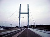 TheTähtiniemi Bridgein Heinola
 -
 The celebrated Sibelius Hall is the heart of Lahti's cultural life
 -
 Ski jumping hills in Lahti; also a venue forSki Jumping WC
 -
 A rock cleft in Hollola
 -
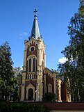 The Gothic Revival church in Kärkölä
 -
 Lake Vesijärvi in Asikkala
 -
 A windmill in Hartola
 -
 A typical traditional Tavastian village view, Orimattila
 -
 National romantic municipal house in Hollola
 -
 Architecture in Lahti
 -
 Pyhäniemi Manor, Hollola
 -
 An old mill at River Vääksynjoki, Asikkala
 -


References
edit- ^Regions and Cities > Regional Statistics > Regional Economy > Regional GDP per Capita,OECD.Stats. Accessed on 16 November 2018.
- ^"Luokitus: Maakunnat 2022 | Tilastokeskus".
- ^"EURES - Labour market information - Päijät-Häme - European Commission".ec.europa.eu.Retrieved2016-08-09.
- ^abAarrevaara, Eeva; Uronen, Carita; Vuorinen, Tapani (2006)."Päijät-Hämeen maisemaselvitys"(PDF).Lahden ammattikorkeakoulun julkaisu(in Finnish). Sarja Artikkelikokoelmat, raportit ja muut ajankohtaiset julkaisut, osa 22. Lahti:LAB University of Applied Sciences(Lahden ammattikorkeakoulu): 8–9.ISSN1457-8328.Retrieved2024-04-22.
- ^Aarrevaara, Eeva; Uronen, Carita; Vuorinen, Tapani (2006)."Päijät-Hämeen maisemaselvitys"(PDF).Lahden ammattikorkeakoulun julkaisu(in Finnish). Sarja Artikkelikokoelmat, raportit ja muut ajankohtaiset julkaisut, osa 22. Lahti:LAB University of Applied Sciences(Lahden ammattikorkeakoulu): 10–11.ISSN1457-8328.Retrieved2024-04-22.
- ^Aarrevaara, Eeva; Uronen, Carita; Vuorinen, Tapani (2006)."Päijät-Hämeen maisemaselvitys"(PDF).Lahden ammattikorkeakoulun julkaisu(in Finnish). Sarja Artikkelikokoelmat, raportit ja muut ajankohtaiset julkaisut, osa 22. Lahti:LAB University of Applied Sciences(Lahden ammattikorkeakoulu): 14–19.ISSN1457-8328.Retrieved2024-04-22.
- ^Aarrevaara, Eeva; Uronen, Carita; Vuorinen, Tapani (2006)."Päijät-Hämeen maisemaselvitys"(PDF).Lahden ammattikorkeakoulun julkaisu(in Finnish). Sarja Artikkelikokoelmat, raportit ja muut ajankohtaiset julkaisut, osa 22. Lahti:LAB University of Applied Sciences(Lahden ammattikorkeakoulu): 54–59.ISSN1457-8328.Retrieved2024-04-22.
- ^Aarrevaara, Eeva; Uronen, Carita; Vuorinen, Tapani (2006)."Päijät-Hämeen maisemaselvitys"(PDF).Lahden ammattikorkeakoulun julkaisu(in Finnish). Sarja Artikkelikokoelmat, raportit ja muut ajankohtaiset julkaisut, osa 22. Lahti:LAB University of Applied Sciences(Lahden ammattikorkeakoulu): 20–21.ISSN1457-8328.Retrieved2024-04-22.
- ^Päijät-Häme – Kuntaliitto(in Finnish)
- ^Maakuntatunnukset – Päijät-Hämeen liitto(in Finnish)
- ^"Artjärvi ja Orimattila yhteen 2011".Yle(in Finnish). 22 March 2010.Retrieved7 August2022.
- ^Tuomisto, Emmi (30 December 2016)."Hämeenkosken hyvä henki kukoistaa kuntaliitoksen jälkeenkin".Etelä-Suomen Sanomat(in Finnish).Archivedfrom the original on 7 August 2022.Retrieved7 August2022.
- ^Räty, Nina (26 June 1996)."Heinolat yhdistyvät sittenkin - ja vauhdilla KHO kumosi lääninoikeuden päätöksen tasa-arvopykälien rikkomisesta".Helsingin Sanomat(in Finnish). Helsinki: Sanoma Media Finland Oy.Retrieved7 August2022.
- ^Uuskallio, Vili (29 December 2016).""Lahden ja Nastolan liitoksesta seurannut jotain hyvääkin"".Etelä-Suomen Sanomat(in Finnish).Retrieved7 August2022.
- ^Korhonen, Antti-Jussi (31 December 2020)."Iitti vaihtaa maakuntaa huomenna – kaikkiaan viisi kuntaa vaihtaa maakuntaa".Yle(in Finnish).Retrieved26 September2022.