TheRiver Torrens/ˈtɒrənz/(Karrawirra Parri/Karrawirraparri) is the most significant river of theAdelaide Plains.It was one of the main reasons for the siting of the city ofAdelaide,capital ofSouth Australia.It flows 85 kilometres (53 mi) from its source in theAdelaide HillsnearMount Pleasant,across the Adelaide Plains, past thecity centreand empties intoGulf St VincentbetweenHenley Beach SouthandWest Beach.The upper stretches of the river and the reservoirs in itswatershedsupply a significant part of the city'swater supply.
| Torrens Karrawirra Parri[1] | |
|---|---|
 View of Elder Park, the Riverside Precinct and the Torrens Lake, before construction of the pedestrian bridge in 2014. | |
 Torrens catchment, creeks and reservoirs | |
 Location of theriver mouthinSouth Australia | |
| Etymology | Robert Torrens[2] |
| Native name | |
| Location | |
| Country | Australia |
| State | South Australia |
| Region | Adelaide Plains |
| Physical characteristics | |
| Source | Mount Lofty Ranges |
| • location | Mount Pleasant |
| • elevation | 480 m (1,570 ft) |
| Mouth | Gulf St Vincent |
• location | Henley Beach South |
• coordinates | 34°55′S138°36′E/ 34.917°S 138.600°E |
• elevation | 0 m (0 ft) |
| Length | 85 km (53 mi) |
| Basin size | 508 km2(196 sq mi) |
| Discharge | |
| • location | mouth[3] |
| • average | 0.71 m3/s (25 cu ft/s) |
| Basin features | |
| Reservoir | Kangaroo Creek Reservoir |
| [4] | |

Tapleys Hill Road
The river is also known by the nativeKaurnaname for the river—Karrawirra Parri or Karrawirraparri (karrameaningredgum,wirrameaning forest andparrimeaning river), having been officially dual-named in 2001.[1][5]Another Kaurna name for the river wasTarndaparri(Kangaroo river).[6]The river was thought to be a reflection of theMilky Way( "wodliparri" ), and was the heartland of theKaurna people,who lived along its length and around the tributary creeks.[7]
At its 1836 exploration byWilliam Light,an inland bend was chosen as the site of theAdelaide city centreandNorth Adelaide.The river was first named theYatalaby the initial exploration party, but later renamed to honourRobert Torrenssenior, chairman of the board ofColonisation Commissioners for South Australiafrom 1834 to 1841 (when he was sacked). From March 1837 settlers camped in tents and makeshift huts along the west end of the River Torrens and freely used the river's resources. A Native Location was created on the north banks of the Torrens and indigenous labour was often used by the settlers for tasks such as hewing wood or delivering water.[8]During the early years of settlement, the river acted as both the city's primary water source and mainsewer,leading to outbreaks oftyphoid.[9]
Since European settlement the river has been a frequently toutedtourist attraction.The river's longlinear parksand a constructed lake in the lower stretch are iconic of the city. The river's flora and fauna have been both deliberately and accidentally impacted sincesettlement.In the 19th century, native forests were cleared, gravel removed for construction and many foreign species introduced. With construction of the linear parks, many species native to the river have been replanted, and introduced species have been controlled as weeds.
The river and its tributaries are highly variable in flow, and together drain an area of 508 square kilometres (196 sq mi). They range from sometimes raging torrents, damaging bridges and flooding city areas, to trickles and completely dry in summer. Winter and spring flooding has prompted the construction of flood reduction works. A constructed sea outlet, landscaped linear parks and three holding reservoirs contain peak flow.
Physiography
editThe River Torrens runs largely westward from the Adelaide Hills, through the centre of Adelaide to the Gulf St Vincent. It originates close to the easternfault scarpof theMount Lofty Ranges,nearMount Pleasant,approximately 480 metres (1,575 ft)above sea level.It runs predominantly alongfaultednorth-south ground structures, which were formed over 250 million years ago during thePaleozoicera then further dislocated during theCretaceousand earliestTertiary.There is a 400-metre (1,300 ft)subsidencealong the Para Fault which also affects the rivers flow. This subsidence was formed in the last two million years, after thePlioceneera.[2]
From its origin toBirdwoodthe river follows rolling, relatively level country before entering a hilly section that continues toGumeracha.The river then followssedimentary rockstratabefore entering agorgeafterCudlee Creek.It flows through the gorge toAthelstone,passing over the Eden Fault Zone of theAdelaide Hillsface and associated escarpment. After the scarp it flows over sedimentary rocks of varying resistance toerosion,which has led to interspersed narrows and broad basins.[2]From the base of the Adelaide Hills to theAdelaide central business districtit runs in a shallow valley with a terraced floor, then down the slope of its ownalluvial fan.The structure of this fan shows that the river formerly entered Gulf St Vincent via thePort River.Over time the Torrens depositedsediment,choking its own outflow; becoming locked behind coastal sand dunes and forming the swampy areas of theCowandillaPlains andThe Reedbeds.[2]
Tributaries
editThe Torrens is fed by numerous seasonal creeks, which are dry for most of the year in their lower reaches, but prone to occasional flooding during the winter and spring. There are five main creeks that join it from the southern side as it crosses theAdelaide Plainseast of Adelaide, and at least five more in its path through the Adelaide Hills.[10]
The plains tributaries, known as First to Fifth Creeks, lie to the east of the city, with First being the most southerly and the rest numbered consecutively northward. They were once named Greenhill, Hallett, Todd, Anstey and Ormsby rivulets respectively, and hadKaurnanames before European settlement.[11]
First, Second and Third Creeks have been particularly heavily modified. Some sections have been converted to concrete channels; others run through landscaped private gardens and some run in underground pipes. Much of the original vegetation has disappeared from the creeks, particularly those closest to the city. Introduced species includingolives,bamboo,boxthorn,watsoniaandblackberrieshave displaced native flora.[12]There is some risk of flooding from all of these eastern suburbs creeks, as shown by the Floodplain Study, which includes plans and maps drawn up by theCity of Burnsideand neighbouring councils.[13]

First Creekbegins inCleland Wildlife Parkon the western side ofMount LoftyandCrafers,flows north-west through the south-eastern suburbs, past a drop at theWaterfall Gullyfalls, throughHazelwoodandTusmore Parks,andMarryatville High School,before discharging into the Torrens nearAdelaide Zoo.Much of its course through the suburbs has beencanalised,some underground.[14]About 7.5% of its flow is diverted as it flows through theAdelaide Botanic Gardento create theFirst Creek Wetland,a scheme set up to ensurewater securityand to encourage diversity of flora and fauna in the area, thus helping to maintain healthy urban environments.[15]Botanic Creekruns through the easternAdelaide parklandsfrom south to north, into theAdelaide Botanic Gardenbefore joining First Creek.[16][17]
Second Creekarises in theSummertownarea of theAdelaide Hills,north of First Creek, and flows throughGreenhill,through Slape Gully, entering the more populated suburbs as it flows through theMichael Perry ReserveinStonyfelland onwards through the eastern suburbs ofErindale,Marryatville,Kensington(open at Borthwick Park[18]) andNorwood,[19]much of it canalised underground[20]as far asSt Peters.The St Peters section is an open canal shortly before it joins the Torrens. It was once called Hallet's Rivulet.[21]Stonyfell Creek,arising on the eastern boundary ofStonyfell,flows throughKensington Gardens,including an open stretch in the Reserve before again being piped underground under West Terrace, passing underKensington ParkandBeulah Park.It joins Second Creek near the junction of Magill andPortrush Roads.[17]
First and Second Creeks come within about 46 metres (50 yd) of each other in Marryatville, with formerly only flat land between them.[21]
Third Creekarises nearNorton Summitand flows through the suburbs ofMagill,Tranmere,Trinity GardensandPayneham,much of the way underground, before discharging into the Torrens atFelixstow.[22][17]
Fourth Creek,orMorialta Creek,arises on the other side of Norton Summit, with various tributaries flowing into it fromMarble HillandLobethal.It is most well known for its falls inMorialta Conservation Park.[23]"Moriatta", a Kaurna word meaning "ever flowing", is now the official name of Fourth Creek. This name has been adapted to Morialta, which is now the name of anelectoral district,schooland the park through which the creek flows.[11][17]
Fifth Creekarises within the Morialta Conservation Park, runs alongside Montacute Road for some way and discharges into the Torrens atAthelstone.[17][24]
The largest catchment of the Torrens isSixth Creekin the Adelaide Hills, which joins the Torrens atCastambulonGorge Road.[25]
Water flow
edit
At the time of European settlement the river was a summertime chain ofwaterholesbounded by largegum trees.Flowing through the area where the city of Adelaide is sited the river was sometimes invisible beneath itsgravelstream bed.It frequently flooded in winter and did not reach the sea, instead ending at coastalduneswhere its waters created a vast but shallow freshwaterwetlands.These wetlands, known asThe Reedbedsafter the dominant vegetation, occupied a large area of the westernAdelaide Plainsand were also fed by other waterways.[9]
The river only flowed to the sea through thePort River,Barker Inlet,andPatawalonga Riverfollowing heavy rain.[26]
The river's catchment area of approximately 500 km2(193 sq mi) is the largest of any waterway within the Adelaide region. The upper reaches are used to create apotable watersupply formetropolitanAdelaide with the river supplying three of Adelaide's eight reservoirs.[9]The upper catchment has an average annual rainfall of between 575 millimetres (22.6 in) at its eastern end to 1,025 millimetres (40.4 in) nearUraidla.[27]The Torrens has a very variable flow leaving earlysettlersto use trial and error in determining bridge heights, with many bridges consequently being washed away.[28]Due to the variability ofAdelaide's climate,flow rates can change from a trickle to flood conditions quickly. On 5 June 1889, prior to major flooding, the flow rate before it entered the suburbs was 0.7cubic metres per second(25cu ft/s), rising to 129.1 m3/s (4,560 cu ft/s), eight days later.[29]
What the River Torrens may be capable of performing for a week or two of the rainy season beyond sweeping down to the swamp the summer filth of Adelaide we cannot guess; but the Torrens at other times is not a river at all, but merely a chain of fresh water pools. At the present moment, its running water may be spanned with the hand and sounded with the forefinger
— The Register, 1838[30]
Since settlement it has repeatedly flooded, sometimes with disastrous consequences. Adelaide's western suburbs were especially prone to flooding due to their location on the river's alluvial fan.[31]As development of Adelaide progressed the amount of rainfall required for flooding decreased and consequent damage increased. Increasedstormwaterrunoff, modification of the river's banks and other changes all served to exacerbate the problem. Work done by various groups to minimise flooding was often counter productive with the creation oflevees,moving and widening channels and other works simply shifting the flooding elsewhere.[32]
Two early floods were, 18 September 1841 which resulted in two peopledrowningwhile trying to cross the river atKlemzig,and 22 September 1844, the largest recorded since settlement began, when "Shands' Brewery" was washed away after the river undermined itsfoundations.[30]The 1899 flood was particularly widespread with extensive flooding of both the river and itstributaries,after a year with 785.6 millimetres (30.93 in) of rain compared to the Adelaide average of 530 millimetres (21 in). The river floodedmarket gardensand farms throughout its hills course causing extensive damage.Norwoodwas inundated toThe Parade,Adelaide toPirieandRundleStreets, and many areas west of the city were left in a shallow lake.[33]The river ran 9 feet (2.7 m) deep over the weir near Thorndon Park Reservoir, 3 feet (0.9 m) over the Torrens Lake Weir and 1 foot (0.3 m) over theMorphett StreetBridge. TheUnderdale(or Holbrooks) Bridge was destroyed, the Torrens Lake weir's bridge damaged, and theFelixstow Bridgeover the Fourth Creek washed away.[34]
European exploration and naming
edit
The first European sighting of the river was in November 1836 by an exploration party comprising LieutenantW.G. Field,John MorphettandGeorge Strickland Kingston.The river was named "The Yatala" by the party[35]but later renamed by Surveyor General ColonelWilliam LightafterRobert Torrens,chairman of theSouth Australian Colonisation Commission.[2][36]On 29 December 1836 Light announced the location of the new city of Adelaide, 6 miles (9.7 km) inland on the river's banks.[35]The first Europeans to explore the Torrens Gorge to the headwaters and sources of the river were DrGeorge ImlayandJohn Hillin January 1838.[37][38]
In recent years the river has been dually known by the indigenous Kaurna people's name ofKarra wirra-parri(meaning river of theRed Gumforest), referring to the denseeucalyptusforest that lined its banks prior to clearing by early settlers.[39]This name, alternativelyKarra-weera,only referred to the lake section of the river, between Adelaide and North Adelaide. It was known asKarrundo-inggaatHindmarsh,Witoingganear the reed beds, andYertalaeverywhere when in flood, which has survived asYatalain the naming of various places in Adelaide.[35]
Pirltawardli,now within Park 1/Pitawardli, a location next to the river near the weir, on the western side ofNorth Adelaide,is an area of great historical significance, as the location of a Kaurna camp and later the firstChristian missionand school in South Australia. The missionaries documented theKaurna language,which formed the basis of the 21st-centurylanguage revivalof the language. The "native location" and school moved from the southern side of the river (nowBonython Park) to the northern side several times.[40]
Changes after 1836
edit
During early years of colonisation, the surrounding trees were cut down and the river'sgravelused in road making and construction of buildings. As the natural environment was removed, the banks were eroded and the riverbed gradually levelled as waterholes filled. By 1878 the river was noted to be a malodorous, black sewer rather than the sylvan stream of the 1830s.[41]
...anything in the guise of a river more ugly than the Torrens would be impossible to either see or describe...
— Anthony Trollopeprior to 1880[42]
Much of the river's catchment area consists of clearedfarmlandwith run-off captured in privatedamsto sustain farming over Adelaide's dry summer. Combined with the river's use for potable water this has greatly reduced the overall flow especially in the lower river.
Flood mitigation
editA flood mitigation bill was passed in 1917 to not only combat the damage caused by floods but also the public health risk due to the lack of mainsseweragein the western suburbs. Popular opinion favoured diverting the flood waters into their "natural" outlets of the Port andPatawalongaRivers. The chief engineer of the department of works favoured a cutting through sand dunes nearHenley Beachallowing the river an outlet, mitigating floods and preventing silting of the Port River. He also advocated the construction of a reservoir where theKangaroo Creek Reservoiris now, to both mitigate floods and provide summerirrigationwater for market gardens. Unfortunately the bill lapsed with no action as thegovernmentandlocal councilswere unwilling to fund the works.[43]TheMillbrook Reservoiropened in 1918 as a summer water source, and flood mitigator if required. A bill was passed in 1923 to enact the earlier plan of cutting through the dunes and adding an upstream regulating weir. Again the bill lapsed due to a lack of commitment from parties on payment.[44]

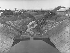
A major flood in 1931 and another in 1933 led to the latest in a series of government enquiries. In 1934 the "Parliamentary Standing Committee on Public Works" recommended that an outlet for the river be created to accommodate flows of up to 370 m3/s (13,000 cu ft/s), covering a 1-in-60-year flood. The work was partly financed by aCommonwealth Governmentgrant with theState Governmentarranging for the balance. The State Government, western and eastern local councils and theMunicipal Tramways Trustshared interest costs. The scheme was enacted in 1935 with the construction of theBreakout Creek(also sometimesBreakout Channel) to take the Torrens westwards to the sea, completed in 1937.[45][46][47][48]The scheme involved diversion of the river atLockleys(nearAdelaide Airport), with the original channel blocked and a new channel created to the sea.[9]Thereedbeds and swampswere subsequently drained and some of their area is now the site for the suburb ofWest Lakes.
-
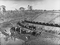 Horse-drawntramway
 -
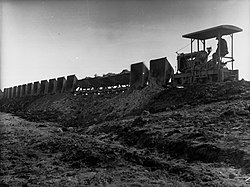
-
 Channel
 -
 Bridge


Based on recommendations in a 1925 report on flood mitigation, work began in the 1960s on the building of the Kangaroo Creek Reservoir, opened in 1969 with a capacity of 24.4 megalitres (860,000 cu ft).[49]It remains the only reservoir damming the river rather than being fed from weirs. The "River Torrens Committee" was formed in 1964 to advise the minister of works on preserving and enhancing the river's natural beauty, and developing it for recreational uses. The "River Torrens Acquisition Act 1970–72" was passed, authorising the purchase of land, in some cases 60 metres (200 ft) back from the top of the river's banks.[50]
By 1980, further development along the riverbanks and removal of levées had reduced the outlet's capacity to a 1-in-35-year flood. A study showed that a 1-in-200-year flood would inundate 13,000 properties; so the Kangaroo Creek dam's level was raised, itsspillwaymodified, the Breakout Creek channel capacity increased and some bridges reinforced.[51]A development plan was approved in 1981 to purchase land along the length of the river, create a flood mitigatinglinear parkand also to modify the Kangaroo Creek dam further. The sea outlet was enlarged to a capacity of 410 m3/s (14,000 cu ft/s) which now covered a 1-in-200-year flood.[52]When theO-Bahn Buswaywas opened, the bridges were designed to cope with this scale of flood, although the two bridges inSt Peterswould likely be awash.[53]
Torrens Lake
edit
The 470 ML (17 million cu ft)[54]Torrens Lake was created in 1881 with the construction of a weir, landscaping ofElder Parkand modification of the river's bank and surrounds into an English formal park. The lake forms a centrepiece of many Adelaide events and postcard scenes. Elder Park with its ironrotundawas opened on 28 November 1882. The Rotunda is a largelyGlasgowbuilt 9-metre-high (30 ft) iron bandstand which was funded by SirThomas Elder,the park being named after him.[55]
In 1867, prison labour from nearbyAdelaide Gaolwas used to build a wooden dam near the site of the current weir. The dam was poorly constructed and almost immediately the Torrens washed it away. Construction of a permanent concrete weir was begun in November 1880 and completed, at a cost of £7,000, in 1881. The sluice gates were closed to begin filling the 12-hectare (30-acre) Torrens Lake on 1 July 1881. At the lake's official opening on 21 July 1881 an estimated 40,000, almost the entire population of Adelaide, attended. During the 1889 flood, the weir was overwhelmed, its gates jammed, and in trying to free them the weir's designer John Langdon was crippled.[42]The weir was rebuilt from 1928 to 1929 with its footbridge relocated and the centre section replaced. The gates can now be fully raised and the river allowed to flow unimpeded.[56]


The "Popeye"boats are privately owned recreationalferriesthat operate on the lake between Elder Park and theAdelaide Zoo.The first boat was launched on the Torrens Lake by Gordon Watts in 1935. It was a 25-foot (7.6 m) boat, built on the banks of the Torrens to hold up to 20 passengers and namedPopeye 1.Watts purchased a formerGlenelgcruise boat in 1948 and placed it in service asPopeye 2.Over the next two years three newjarrahhulled boats were built atPort Adelaide;carrying 40 passengers each they were numberedPopeye 3throughPopeye 5.Trips on the Popeyes from Elder Park to the zoo became a treasured family outing and the boats hosted weddings and other events.[57]In March 1962 Keith Altman, owner of riverside eatery "Jolley's Boathouse", took over the Popeyes and introduced recreationalpaddle boatsto the river. The Popeyes had a brush with royalty in March 1977 withPopeye 5ferryingQueen Elizabeth IIandPrince Philipfollowed by a choir inPopeye 4.Prime MinisterMalcolm Fraserofficially launched three new fibreglass models named PopeyesI,IIandIIIin 1982 as the wooden boats' replacements.[58]
Water use
editIn the early days of Adelaide, the Torrens was used for bathing, stock watering, rubbish disposal, water supply and as a de facto sewer and drainage sump. This led to a range of health issues until finally, in 1839, when a dysentery outbreak killed five children in one day, Governor Gawler forbade bathing, clothes washing and the disposal of animal carcases in the Torrens within 1.6 kilometres (1 mi) of town. The quality of the river's water was not helped by water supply methods. Carters used to drive water carts into the Torrens to refill. To prevent this the State Government in 1852 built a facility with steam powered pumps and water storage, from which the carters then filled their casks.[59]
The "Waterworks Act" of 1856 was passed to enable damming of the upstream Torrens for water supply purposes.[60]The resulting "Water Commission" arranged the following year for foundations to be laid for a water supply weir 11 kilometres (7 mi) from Adelaide nearCampbelltown.Unsuitable geology and shoddy work by contractors Frost & Watson led to it being washed away in July 1858 and the site abandoned. EngineerHamiltonwas replaced byJohn England.Government then created a Waterworks Department, which started construction of a weir 16 kilometres (10 mi) from the city and reservoir at Thorndon Park in 1859.[61]The weir was completed on 4 June 1860 and the reservoir began supplying piped water in December. Engineer England was found by a Select Committee to have overpaid the contractors and forced to resign.[62]The water was captured at the weir, piped for storage to the Thorndon Park Reservoir then to a water tower at Kent Town. Water from Kent Town storage was distributed via a manually controlled water system, unmetered for its first six years.[63]Within six years 20,000 citizens in Adelaide and Port Adelaide were connected to reticulated water from the Torrens.[64]By 1872, the 2,840 ML (620 million imp gal; 750 million US gal)Hope Valley Reservoirin the foothills of the Adelaide Hills was completed as a storage reservoir, supplied via an aqueduct and tunnel.[65]
Public baths were built in 1861 just north of the currentParliament House.They were supplied with reticulated water from the Torrens and progressively upgraded with the last change a 1940 remodelling including an Olympic-size swimming pool and diving tower. The baths were demolished in 1970 to make way for theAdelaide Festival Centre.[66]The 16,500 ML (3.6 billion imp gal; 4.4 billion US gal) Millbrook Reservoir was constructed high in the Adelaide Hills from 1913 to 1918 submerging the town of Millbrook. An earth bank dam fed by mile long tunnel from a weir on the river atGumeracha,its elevation allows gravity supply of water to Adelaide's eastern suburbs.[67]
Bridges
editDue to the river's path through the centre of Adelaide, transport necessitated the construction of many bridges. Prior to the bridges all crossings had been viafordswhich proved a dangerous practice in winter and spring. The first bridge was one of timber built in 1839 approximately 500 metres (1,600 ft) west of the current City bridge, but destroyed by floods in September 1844.[55]In 1849 £6,000 was allocated to bridge the Torrens. Within four years three wooden bridges had been built and subsequently destroyed in floods.[60]The bridges listed below are from up-river to down-river.
| Location | Bridge name | Image | Comments/use | Notes |
|---|---|---|---|---|
| Mount Pleasant | Carries Cricks Mills Road (B35) |
|||
| Birdwood | Carries Warren Road (B34) |
|||
| Gumeracha | Carries Forreston Road | |||
| Carries Torrens Valley Road (B10) |
||||
| Carries Gorge Road (T58) |
||||
| Cudlee Creek | Carries Gorge Road (T58) |
|||
| Union Bridge[68] | Carries Gorge Road (B31) (T58) |
|||
| Carries Gorge Road (B31) (T58) |
||||
| Paracombe | Carries Gorge Road (B31) (T58) |
|||
| Highbury | ||||
| Dernancourt | Carries Lower North East Road (A11) |
|||
| CarriesNortheast Busway | ||||
| Paradise | Dickson's Crossing | Built in 1977 and carries Darley Road; replaced an earlier ford. | [70] | |
| Windsor Gardens | ||||
| Klemzig | ||||
| Carries Northeast Busway | ||||
| Carries Riverside Drive | ||||
| Marden | Felixstow Bridge | Built in 1873 and carries OG Road, the bridge was reconstructed in 1892, 1901, 1924 and 1961. The first bridge was narrow, and hay-laden carts often damaged posts while brushing past them. | [70] | |
| Klemzig |  |
Carries Northeast Busway | ||
| Vale Park | Ascot Bridge | Built in 1970 and carries Ascot Avenue (A17) |
||
| Marden | Carries Northeast Busway | |||
| Royston Park | Carries Northeast Busway | |||
| Walkerville | Carries Northeast Busway | |||
| Carries Northeast Busway | ||||
| St Peters | Carries Northeast Busway | |||
| Gilberton | Tennyson Bridge | Built 1877 and carries Stephen Terrace, the bridge replaced a ford at the same site. | [70] | |
| Carries Northeast Busway | ||||
| Swing Bridge | Carries Swing Bridge Lane | |||
| St Peters | Carries Northeast Busway | |||
| Gilberton | Carries Shared Park | |||
| Hackney | Hackney Bridge | First known as the "Second Company Bridge" as theSouth Australia Companybuilt it, the bridge was built so that wheat farmers from the northern side could access the South Australian Company'sflour millwhich stood where the Hackney Hotel was later built. The current bridge is the third at the same site; in 1845 "Prescott's Crossing" was built as a timber beam bridge, 1860 saw it replaced with a four span, trussed timber bridge and 5 December 1885 with a 38-metre-long (126 ft), 10-metre-wide (34 ft)truss arch bridge.Carries Hackney Road (A21) |
[70][71] | |
| Adelaide | Torrens River Park Pedestrian Bridge | Located east of the zoo, the bridge was opened in late 2009 and is well patronised by cyclists. | ||
| Albert Bridge |  |
Located adjacent to theAdelaide Zoo,the bridge carriesFrome Roadover the river. A timber bridge was constructed in 1859, west of the current bridge, and named theOld Frome Bridge.The current bridge was named afterPrince Albert,royal consort to Queen Victoria, on 7 May 1879. Thewrought ironstructure is made from three parallel, scalloped girders that were manufactured in England. It is 36.6 metres (120 ft) long with acantilevered spanof 18 metres (60 ft). The bridge is 13 metres (43 ft) wide and originally had a timber deck, which was replaced with concrete in 1922. The coats of arms on the inside of the bridge contains the city's motto,Ut Prosint Omnibus Conjunctiwhich translates as "united for the common good." The bridge is listed on the "City of Adelaide Heritage Register", the "South Australian Heritage Register"and the"Register of the National Estate".A complete restoration was finished in 1982, with the bridge now appearing as it did at the 1879 opening. | [70][72][73] | |
| University Footbridge |  |
The footbridge connects Victoria Drive, at the rear ofUniversity of Adelaide,withUniversity Oval,War Memorial Drive. The bridge was conceived in 1928 by an engineeringundergraduateat the university and funded with a £26,000 grant from Adelaide City Council. It was designed by university staff under the supervision of Robert Chapman, chief engineer of theSouth Australian Railways.Construction was delayed until 1937 due to the economic effects of theGreat Depression.The bridge has an arch spanning 46 metres (152 ft), 6.1 metres (20 ft) over the river, and was the firstweldedbridge in South Australia. A murder that occurred in the vicinity of the bridge on 10 May 1972 resulted in calls to reform South Australia's laws regarding homosexuality. University of Adelaide law lecturerDr George Duncanwas thrown into the river. A plaque on the bridge commemorates his death and the subsequent decriminalisation of homosexuality in South Australia. | [74][75][76][77] | |
| City Bridge |  |
The English manufactured, iron bridge was opened in June 1856, extendingKing William StreettoNorth Adelaide.It was widened in 1877 then converted into a two-lane bridge in 1884. In 1929 a new wider, concrete bridge was proposed, to be the same width as King William Road and would relieve congestion, particularly on match days at theAdelaide Oval.The bridge was duly replaced in 1931 with theconcretearch structure proposed in 1929. The distinctive lamp fittings and their pylons were designed by South Australian artistJohn C. Goodchild. | [78][79][80] | |
| Adelaide Oval Footbridge |  |
|||
| North Adelaide | Victoria Bridge | The bridge extends fromMorphett Streetand crosses the rail lines from theAdelaide railway stationand the river. The first bridge was opened on 21 June 1871, having been shipped over from Britain on the shipSouth Australianin 1869.[81]Over time various bridges have been built on the same site. The current bridge, aprestressed concretebox girder bridge,was opened in March 1968 byPremierDon Dunstan,andAdelaide Lord MayorWalter Lewis Bridgland.The bridge is constructed as two bridges joined to appear continuous. The first spansNorth Terraceand the rail lines, and the second the river. The bridge was designed without a central pillar in the river, allowing three lanes ofrowersto compete without interference. | [60][82] | |
| Railway Bridge | Built in 1856 to carry thePortandGawlerrailway lines. The bridge was constructed 1.5 kilometres (0.9 mi) fromAdelaide railway station. | [83] | ||
| Thebarton | Hindmarsh Bridge |  |
CarriesPort Road(A21) |
|
| Hindmarsh | Sir William Goodman Bridge |  |
The Sir William Goodman Bridge, originally never named, formed the link for the Thebarton-Hindmarsh tramway, crossing the River Torrens at Holland Street, Thebarton to an intersection of Adam and Manton Streets, Hindmarsh. The bridge was built in 1909 and used byMunicipal Tramways Trusttrams until 1953. Buses exclusively used the bridge until 1962, when it was used by general road traffic. The bridge was closed off in 1990 due to the age and unsafe nature of the structure. In 2014, the bridge was completely restored and reopened for pedestrian and cycle traffic. It is notable as being the first reinforced concrete bridge constructed in Adelaide. On its reopening, it was named the Sir William Goodman Bridge afterthe first Chief Engineer and General Manager of the MTT. | |
| Thebarton | Taylors Bridge | CarriesSouth Road(A13) |
||
| Torrensville | Carries McDonnell Avenue | |||
| Underdale | Holbrooks Bridge | Carries Holbrooks Road (A14) |
||
| Flinders Park | Keele Bridge | Carries Rowells Road (south)/Findon Road (north) | ||
| Lockleys | Kidman Bridge |  |
CarriesHenley Beach Road | |
| Fulham,& West Beach |
Davis Bridge | Carries Tapleys Hill Road | ||
| West Beach& Henley Beach South |
Seaview Road Bridge | Carries Seaview Road |
Flora and fauna
editThe river was formerly a food source withyabbies,musselsand small fish, however the reduction in water quality, changing of the river's habitat, and introduction of European fish species has led to a reduction in fauna quantity and diversity.[41]Exoticpestspecies such as theEuropean carp,redfin perchandtrouthave greatly reduced native fish populations like the big headedgudgeon(Philypnodon grandiceps) but nativewaterfowlare common along the river withPacific black ducks,Australian wood ducks,black swans,ibis,egretsandheronsamongst the more than 100 species seen. The number of exotic waterfowl species such asmallardshas reduced in recent years. In places the steep banks of the river are an ideal habitat for long-neckedtortoises.[citation needed]
The river, and its tributaries, had a population ofwater rats(Hydromys chrysogaster) andAustralian swamp rats(Rattus lutreolus). Water rats remain in reduced numbers, but the introducedblack rat(Rattus rattus) andbrown rat(Rattus norvegicus) have largely supplanted the natives. Thehouse mouse(Mus musculus) is now the most commonmammalof the Torrens environ.[84]
Widely found nativereeds,sedgesandrushesalong the upper river arebulrush,knobby club rush, spike rush, common reed, sea rush andpale rush.River red gum (Eucalyptus camaldulensis) and blue gum (Eucalyptus leucoxylon) trees are found along the riverbanks, although sparser than the forest that was seen by European discoverers. Still present are many of the original vegetation species like: Sheoak (Casuarinastricta), native cherry (Exocarpos cupressiformis), native pine (Callitrispreissii) and Australia's floral emblem the golden wattle (Acacia pycnantha)[85]
Today's river
edit

From its source the river flows westwards throughBirdwoodandGumeracha.It then continues down through Torrens Gorge entering suburban Adelaide atAthelstonewith some of its path paralleled by theO-Bahn Busway.It passes between thecity centreandNorth Adelaide,forming the Torrens Lake between theAdelaide Zooand a weir oppositeAdelaide Gaol.The river then continues the remaining eight kilometres to the sea at Henley Beach South, emptying intoGulf St Vincentvia a constructed outlet.
Hope Valley,Millbrookand Kangaroo Creek Reservoirs, which provide water storage for Adelaide, capture the river's flow. These reservoirs form part of the Adelaide Hills catchment, which supplies 60% of Adelaide's water needs in an average year.Adelaide City Counciluses water from the lower river to irrigate the city's surroundingparklands.[86]Rubbish accumulation in the lower river is controlled with numerous collection racks, and sediments and other pollutants are filtered through constructedwetlands.[87]

The earliestlinear river parkin Australia bounds the suburban end of the river. The park is 35 km long with numerous playgrounds walkways and bicycle tracks. On the south bank of the lake, adjacent to theAdelaide Festival Centre,Elder Parkis used for the annualTasting Australiafestival, mass singing ofchristmas carolsat the annual "Carols by Candlelight", and other public events throughout the year. The Popeye tourist boats, small paddle boats and Black Swans of the lake are icons of the area and frequently featured in postcard photographs of the city. Due to now-limited natural river flow andstormwaterborn organic material, the lower river, (particularly the lake), is oftenpollutedwithalgal bloomsand significant levels ofE. coli bacteriain spring and summer. Numerous taskforces have been formed to improve the river'swater quality,including one created in 2006 by the Minister for the Environment and Conservation.[88]
The river is a used by many for recreation, with the footpaths on the riverbanks often filled with cyclists and joggers. Rowers use the lake for training all year round, and many clubs such as theAdelaide University Boat Club,theAdelaide Rowing Club,and the boat houses of the secondary schools which participate in the annualHead of the Riverare located upon its banks. Several rowing regattas are held on the Torrens Lake course in the summer months of each year, contested by both club and school crews.
See also
editReferences
edit- ^ab"Notice to Assign Dual Names to Places"(PDF).South Australian Government Gazette.Government of South Australia. 15 November 2001.Archived(PDF)from the original on 29 March 2019.Retrieved23 July2019.
NOTICE is hereby given [that the] Minister of the Crown to whom the administration of the Geographical Names Act 1991, is committed do hereby 1. Assign the name Karrawirra Parri as an alternative name to that feature also known as River Torrens. Both names, separately or together, would have equal validity as the name of the subject feature [...]
- ^abcdeSmith & Twidale 1987, p.v
- ^Noted as 22.4 GL (790 million cu ft) per year inAdelaide coastal waters study (Spring 2004)."Summary of the literature review and stormwater audit (pdf)"(PDF).City to Sea.1(4): 2. Archived fromthe original(PDF)on 30 September 2009.Retrieved9 September2009.
- ^"Map of River Torrens, SA".Bonzle Digital Atlas of Australia.Archivedfrom the original on 30 October 2021.Retrieved25 March2017.
- ^"River Torrens".SA Location Viewer.Government of South Australia. 7 March 2013. SA0033903.Archivedfrom the original on 19 July 2019.Retrieved23 July2019.
Portions of the river also known by the Aboriginal people as Karra Wirra Parri (that portion in theCity of Adelaide), Korraweera (atHindmarsh), Karraundo Ingga (reedbeds), Witoingga (whole river), Perre, Peere or Parri (in flood) and Yertala
- ^"Karrawirraparri 'Red gum forest river' (River Torrens)".City of Charles Sturt.12 August 2013.Archivedfrom the original on 17 March 2020.Retrieved26 February2020.
- ^"Reconciliation".Adelaide City Council.Archivedfrom the original on 12 July 2019.Retrieved26 February2020.
- ^Sharyn Clarke, "The Creation of the Torrens: A History of Adelaide's River to 1881", University of Adelaide MA Thesis, 2005
- ^abcdKESAB."A LITTLE CATCHMENT HISTORY".Catchment Boards of South Australia. Archived fromthe originalon 3 October 2006.Retrieved21 November2006.
New site:http:// amlrnrm.sa.gov.auArchived24 October 2007 at theWayback MachineActive on 9 September 2009. - ^Smith & Twidale 1987, Figure 1 (River Torrens Catchment)
- ^abWarburton J.W. (editor) 1977, p.25
- ^Warburton J.W. (editor) 1977, pp12-14,116–125
- ^"First to Fifth Creeks".Burnside Council.Archivedfrom the original on 23 June 2019.Retrieved23 June2019.
- ^"First Creek, Waterfall Gully: 2015 Aquatic Ecosystem Condition Report".EPA South Australia.Archivedfrom the original on 24 June 2019.Retrieved24 June2019.
- ^"First Creek Wetland".Botanic Gardens of South Australia.Archivedfrom the original on 24 June 2019.Retrieved24 June2019.
- ^"Adelaide Botanic Garden waterways study: Final report". Ecological Engineering. 29 July 2003.
{{cite web}}:Missing or empty|url=(help) - ^abcdeTonkin Engineering for the Torrens Catchment Water Management Board (March 2007)."First to Fifth Creeks Floodplain Mapping Project"(PDF).Archived(PDF)from the original on 24 June 2019.Retrieved7 July2019.
- ^"Borthwick Park Creek Improvements Draft Concept Plan".City of Norwood Payneham & St Peters.Archivedfrom the original on 16 August 2021.Retrieved16 August2021.
- ^"Second Creek at Norwood".SA Memories.Archivedfrom the original on 14 April 2019.Retrieved24 June2019.
- ^"Second Creek, South Australia".Google Maps.Retrieved24 June2019.
- ^ab"Kensington—Old and New".The Observer (Adelaide).Vol. LXXX, no. 5, 961. South Australia. 28 April 1923. p. 14.Retrieved20 September2020– via National Library of Australia.
- ^"Third Creek, South Australia".Google Maps.Archivedfrom the original on 7 November 2021.Retrieved24 June2019.
- ^"Fourth Creek, South Australia".Google Maps.Archivedfrom the original on 7 November 2021.Retrieved24 June2019.
- ^"Fifth Creek, South Australia".Google Maps.Archivedfrom the original on 7 November 2021.Retrieved24 June2019.
- ^"Sixth Creek Catchment Group – Adelaide, South Australia".sixthcreek.Archivedfrom the original on 16 July 2011.Retrieved26 April2010.
- ^"Wetlands of the catchment".Torrens catchment water management board. 5 July 2005. Archived fromthe originalon 3 October 2006.Retrieved21 November2006.This site is LONG dead.
Try:http:// amlrnrm.sa.gov.au/Caring_for_Water_Seas/Creeks_Rivers/River_Torrens.aspxArchived12 September 2009 at theWayback MachineRetrieved on 9 September 2009. - ^Surface Water Group (June 2003).Report DWLBC 2003/24, Surface Water Assessment of the Upper River Torrens Catchment (Figure 16).Adelaide: The Department of Water, Land and Biodiversity Conservation.
- ^Smith & Twidale 1987, p.1
- ^Smith & Twidale 1987, p.90
- ^abSmith & Twidale 1987, p.4
- ^Smith & Twidale, July 1988, foreword
- ^Smith & Twidale, July 1988, p.2
- ^Smith & Twidale 1987, pp.69–78
- ^Smith & Twidale 1987, pp.79–84
- ^abcAltmann et al. 1999, p.2
- ^Note thatthe ADB entry for Robert TorrensArchived10 November 2019 at theWayback Machinesays that Hindmarsh named it, but other sources contradict this and it seems more likely, as it was Light's choice to site the city across the river.
- ^Supplement toThe Australian,27 March 1838, andRegister,16 June 1838, p. 3.
- ^"South Australia".The Australian.27 March 1838. p. 3.Archivedfrom the original on 7 November 2021.Retrieved5 October2016.
- ^Kaurna Place NamingArchived12 July 2017 at theWayback MachineCity of Adelaide. Retrieved 5 August 2017.
- ^Harris, Rhondda (6 February 2014)."Pirltawadli".SA History Hub(1 June 2017 (updated spelling) ed.).Archivedfrom the original on 7 December 2019.Retrieved7 December2019.
...revised version of an entry first published inThe Wakefield Companion to South Australian History,edited by Wilfrid Prest, Kerrie Round and Carol Fort (Adelaide: Wakefield Press, 2001)
- ^ab"An Essay on the River Torrens".State Library of South Australia, The Manning Index of South Australian History.Archivedfrom the original on 18 September 2009.Retrieved9 September2009.
- ^abAltmann et al. 1999, p.19
- ^Smith & Twidale, February 1988, p.2
- ^Smith & Twidale, July 1988, p.4
- ^"River Torrens".SA History Hub.Archivedfrom the original on 30 November 2020.Retrieved23 November2020.
- ^"The Breakout Creek channel, opened in 1937, gives Adelaide's River Torrens an outlet to the sea in western suburbs".AdelaideAZ.Archivedfrom the original on 23 November 2020.Retrieved23 November2020.
- ^"River Torrens outlet".SA Memory.State Library of South Australia.Archivedfrom the original on 30 November 2020.Retrieved23 November2020.
- ^Smith & Twidale 1989, p.1
- ^Smith & Twidale 1989, p.104
- ^Smith & Twidale 1989, p.103
- ^Smith & Twidale 1989, p.2
- ^Smith & Twidale 1989, p.125
- ^Smith & Twidale 1989, p.132
- ^"Torrens taskforce, storage options".Adelaide and Mount Lofty ranges natural resources management board. 18 April 2007. Archived fromthe originalon 30 August 2007.Retrieved14 October2007.
Try:http:// amlrnrm.sa.gov.auArchived24 October 2007 at theWayback Machine - ^abAltmann et al. 1999, p.4
- ^Altmann et al. 1999, p.20
- ^Altmann et al. 1999, p.21
- ^Altmann et al. 1999, p.22
- ^Altmann et al. 1999, p.6
- ^abcAltmann et al. 1999, p.3
- ^"The Reservoir at Thorndon Park".South Australian Register.Adelaide: National Library of Australia. 18 April 1859. p. 2.Archivedfrom the original on 7 November 2021.Retrieved16 August2014.This article contains a lot of useful information about Thorndon Park reservoir.
- ^Cumming, D. A. and Moxham, G.They Built South Australiapub. by the authors, Adelaide SA 1986ISBN0 9589111 0 X
- ^Altmann et al. 1999, p.7
- ^Hammerton M. 1986, p.25
- ^"Water Supply".Atlas of South Australia 1986.Government of South Australia. Archived fromthe originalon 25 September 2009.Retrieved9 September2009.
- ^Altmann et al. 1999, p.8
- ^Hammerton M. 1986, pp.155–156
- ^"29 Jun 1871 - UNION BRIDGE, CUDLEE CREEK. - Trove".Archivedfrom the original on 7 November 2021.Retrieved3 March2021.
- ^"NEW! First of Its Kind Whisky Distillery & Brewery Coming to Cudlee Creek • Glam Adelaide".3 July 2020.Archivedfrom the original on 25 January 2021.Retrieved3 March2021.
- ^abcdeLewis H. John 1985, p.57
- ^Altmann et al. 1999, p.11
- ^National Library of Australia, TROVE: Opening of the Albert Bridge[permanent dead link]South Australian Register,17 May 1879. Accessed 26 January 2014.
- ^Altmann et al. 1999, p.10
- ^University FootbridgeArchived12 July 2009 at theWayback Machine,adelaide-in-photos.blogspot Retrieved on 9 September 2009.
- ^Kemp, Deane; Pickles, John (1996).Fargher, John Adrian (1901–1977).Vol. 14. Melbourne University Press. pp.138–139.Archivedfrom the original on 16 February 2009.Retrieved9 September2009.
{{cite book}}:|work=ignored (help) - ^Altmann et al. 1999, p.12
- ^"Call for release of documents relating to professor's death".Australian Broadcasting Corporation.10 May 2002. Archived fromthe originalon 17 February 2009.Retrieved9 September2009.
- ^"New City Bridge".The Advertiser.Adelaide: National Library of Australia. 16 February 1929. p. 14.Archivedfrom the original on 7 November 2021.Retrieved15 November2012.
- ^Altmann et al. 1999, pp.3,15
- ^Joyce Gibberd,'Goodchild, John Charles (1898–1980)'Archived8 February 2015 at theWayback Machine,Australian Dictionary of Biography,National Centre of Biography, Australian National University, published first in hardcopy 1996, accessed online 8 February 2015
- ^"South Australian, 1465225 | Historic England".
- ^Altmann et al. 1999, p.18
- ^Thompson & Sampson 2006, p.24
- ^Warburton J.W. (editor) 1977, p.23
- ^Warburton J.W. (editor) 1977, p.11-14
- ^"Water Proofing Adelaide, Exploring the issues – a discussion paper"(PDF).Government of South Australia. Archived fromthe original(PDF)on 26 February 2007.Retrieved22 March2007.
Try: Water Proofing Adelaide A thirst for change 2005–2025BrochureArchived15 September 2009 at theWayback Machine(pdf 8 pages) and/orStrategyArchived15 September 2009 at theWayback Machine(pdf 64 pages) Both published 2005 and Retrieved on 9 September 2009. - ^2006 signage by the (now defunct) Torrens water catchment board (at Breakout Creek near Henley Beach) showed fourconstructed wetlandsand 12 (existing or in construction) trashracks.
- ^Owen, Michael (16 September 2006). "Taskforce to look at ailing Torrens".The Advertiser, Adelaide.News Limited.
Bibliography
edit- Altmann, Keith; Butcher M, Rodda L, Stacey B, Stewien R, Venus R (1999).Ponds, ponts & Pop-eye: notes for an afternoon afloat on Adelaide's River Torrens.North Adelaide: Institution of Engineers Australia, South Australian Division.
{{cite book}}:CS1 maint: multiple names: authors list (link) - Lewis, H. John (1985).Enfield and the northern villages.Enfield, South Australia: Corporation of the City of Enfield.ISBN0-85864-090-2.
- Hammerton, Marianne (1986).Water South Australia, A History of the Engineering and Water Supply Department.Adelaide: Wakefield Press.ISBN0-949268-75-5.
- Payne, Pauline (1996).Thebarton Old and New.Adelaide: Thebarton City Council.ISBN0-646-30157-8.
- Smith, Derek L.;Twidale C.R.(1987).An Historical account of flooding and related events in the torrens river system from first settlement to 1986.Vol. 1,1836–1899. Adelaide: The engineering and water supply department.ISBN0-7243-4248-6.
- Smith, Derek L.; Twidale C.R. (February 1988).An Historical account of flooding and related events in the torrens river system from first settlement to 1986.Vol. 2,1900–1917. Adelaide: The engineering and water supply department.
- Smith, Derek L.; Twidale C.R. (July 1988).An Historical account of flooding and related events in the torrens river system from first settlement to 1986.Vol. 3,1918–1930. Adelaide: The engineering and water supply department.
- Smith, Derek L.; Twidale C.R. (1989).An Historical account of flooding and related events in the torrens river system from first settlement to 1986.Vol. 4,1931–1988. Adelaide: The engineering and water supply department.
- Thompson, Malcolm; Sampson Bob (2006).150 years of the Port Adelaide Railway 1856 to 2006.Port Adelaide:National Railway Museum.
- Warburton, J.W., ed. (1977).Five creeks of the River Torrens.Adelaide: Department of adult education, University of Adelaide.ISBN0-85578-336-2.
Further reading
edit- Adelaide & Mount Lofty Ranges Natural Resources Management BoardArchived24 October 2007 at theWayback Machine
- State Library Manning Index: River Torrens
- Twidale, C.R."River Torrens".SA History Hub.History Trust of South Australia.(CC Attribution-NonCommercial 3.0 Australia Licence)
- "The River Torrens".Campbelltown City Council.– includes some history old photos and citations