This articleneeds additional citations forverification.(March 2024) |
Sandy Springsis a city in northernFulton County, Georgia,United States, and a suburb ofAtlanta.The city's population was 108,080 at the2020 census,[6]making itGeorgia's7th most populous city.It is the site of several corporate headquarters, includingUPS,Newell Brands,Inspire Brands,Focus Brands,Cox Enterprises,andMercedes-Benz USA's corporate offices.
Sandy Springs | |
|---|---|
 The contemporary skyline of Sandy Springs is dominated by theConcourseoffice towers, as seen in 2013. | |
|
Flag  Logo | |
    | |
| Coordinates:33°55′27″N84°22′43″W/ 33.92417°N 84.37861°W[1] | |
| Country | United States |
| State | Georgia |
| County | Fulton |
| Incorporated | December 2005[2] |
| Government | |
| •Mayor | Rusty Paul(R)[3] |
| • City Manager | Eden Freeman |
| Area | |
• Total | 38.52 sq mi (99.77 km2) |
| • Land | 37.66 sq mi (97.53 km2) |
| • Water | 0.86 sq mi (2.24 km2) |
| Elevation | 1,093 ft (333 m) |
| Population (2020) | |
• Total | 108,080 |
| • Rank | 290thin the United States 7thin Georgia |
| • Density | 2,870.04/sq mi (1,108.14/km2) |
| Time zone | UTC−5(EST) |
| • Summer (DST) | UTC−4(EDT) |
| ZIP Codes | 30319, 30327–30328, 30338, 30342, 30350, 30358, 30092[5] |
| Area code | 404/678/770/470 |
| FIPS code | 13-68516 |
| GNISfeature ID | 0332975[1] |
| Website | sandyspringsga.gov |
History
editHuman settlement in the area can be traced back to approximately 400 CE, when Native Americans forged three trails to better access the area's freshwater springs.[7]In the 16th century, theCreek Muskogeetribe settled the area, where they remained until the early 1800s, when they were forced out of the area due to the discovery ofgold.[7]
In 1821, the federal government held a number of land lotteries in the area, resulting in the purchase of land in present-day Sandy Springs and its subsequent settlement.[7]The Austin-Johnson House, the oldest existing unaltered house, was built in 1842 on what is now Johnson Ferry Road.[7]In 1851, Wilson Spruill donated 5 acres (2.0 ha) of land for the founding of Sandy SpringsUnited Methodist Church,near the natural spring for which the city is named.[8]In 1905, the Hammond School was built atJohnson FerryRoad and Mt. Vernon Highway, across the street from the church.[citation needed]
20th century
editIn 1950, the state legislature blocked Atlanta from anne xing the community, which remained rural until the Interstate Highway System was authorized by the Federal-Aid Highway Act of 1956. In 1959, after a fire at Hammond Elementary School,William Hartsfield,the mayor of Atlanta, urged residents to support annexation so that the area would have better firefighting protection. Community opposition killed the proposal. In the early 1960s,Georgia 400andInterstate 285were constructed, connecting Sandy Springs tometro Atlantaand initiating a housing boom that brought new residents and majorland developmentas part of thewhite flightfrom Atlanta after theCivil Rights Movementwon greater racial integration within Atlanta.[9]
In 1965, Hartsfield once again proposed the annexation of the Sandy Springs area. Spokesmen for Sandy Springs promised residents to "build up a city separate from Atlanta and your Negroes and forbid any Negroes to buy, or own, or live within our limits" should they reject annexation.[9]In 1966, annexation by Atlanta was defeated in a referendum, with two-thirds voting against.[citation needed]
Efforts to incorporate Sandy Springs began in 1966 in response to attempts by the city of Atlanta to annex this unincorporated area of northFulton County.[10]
In the early 1970s, the city of Atlanta attempted to use a state law to forceannexationof Sandy Springs, which failed after theSupreme Court of Georgiaruled that the law wasunconstitutional.In response, a group of residents formed the Committee for Sandy Springs 1975 to lobby for the incorporation of Sandy Springs.[7]
During this time, proponents for an incorporated Sandy Springs argued that their taxes were disproportionately going to other, largely non-white, communities in Fulton County.[11]In every legislative session, state legislators representing the area introduced a bill in theGeorgia General Assemblyto authorize a referendum on incorporation.[7]Legislators representing Atlanta and southwestern Fulton County, who feared that tax revenue would be lost from incorporation, blocked the bills,[7]using the procedural requirement that alllocal legislationbe approved first by a delegation of representatives from the affected area.[citation needed]
In 1991, the Georgia state government determined that Sandy Springs, along with other wealthier, and predominantly white, communities in Fulton County was being taxed below statewide minimums, resulting in an increase in taxes for the area.[11]Some Sandy Springs residents, includingMitch Skandalakis,launched a number of campaigns against the taxes, and launched an unsuccessful lawsuit against the state.[11]
On January 16, 1997,Eric Rudolphbombed an abortion clinic in Sandy Springs.[12][13]
21st century
editWhen theRepublican Partygained a majority in both houses of theGeorgia General Assemblyin 2005, the procedural rules previously used to prevent a vote by the full chamber were changed so that the bill was handled as a state bill and not as a local bill.[citation needed]The assembly also repealed the requirement that new cities must be at least 3 miles (4.8 km) from existing cities that had stymied previous attempts to incorporate due to Sandy Springs directly bordering bothRoswelland Atlanta.[citation needed]The bill allowing for a referendum on incorporation was introduced and passed as HB 37.[14]The referendum initiative was approved by the Assembly and signed by GovernorSonny Perdue.
A referendum was held on June 21, 2005, and residents voted 94% in favor of incorporation.[7]In November 2005, voters returned to the polls to elect amayorand sixcity councilmembers.
Formal incorporation occurred on December 1, making Sandy Springs the third-largest city ever to incorporate in the U.S.[2]The city's police force and fire department began service in 2006. Upon incorporation, Sandy Springs initiated a nontraditional approach by operating as apublic-private partnership(PPP), with all but six full-time employees being contracted.[15]
In 2010, the city undertook a procurement process to rebid all general city services, which was won byCH2M Hill.[15]The timing of this contract, during theGreat Recession,allowed the city to leverage a cheaper contract due to the economic downturn.[15]
In 2010, the city became the first jurisdiction in Georgia to successfully "bail out" from the preclearance requirements ofSection 5 of the Voting Rights Act.[16]
In 2019, the Sandy Springs City Council moved to scale back the PPP model, directly hiring 183 contract employees, leaving only 15 outsourced full-time workers by the end of 2019.[17]The city will still outsource a number of services, including the city attorney's office, as well as security, street sweeping and ambulance services.[17]The move was expected to save $2.7 million in the next year and more than $14 million over 5 years.[15][17]
Geography
editThe boundaries of Sandy Springs are Atlanta to the south,Cobb County(at theChattahoochee River) to the west and north,Roswell(also at the river) to the north, andDunwoodyandBrookhaven,at theDeKalb Countyline, to the east. A smallpanhandlein the northeast extends between the Chattahoochee River to the north and Dunwoody to the south, ending in a very small border withPeachtree Cornersin the extreme western edge ofGwinnett County.
Climate
editSandy Springs has ahumid subtropical climate(Köppen climate classificationCfa). During January and February 2014, the Atlanta area, including Sandy Springs, experienced asevere snow stormand asevere ice storm,both of which left much of the region without power, caused major travel disruptions, and the former storm forced people to take shelter in cars and schools as the city was underprepared for the black ice that prevented transport.[18]
| Climate data for Sandy Springs | |||||||||||||
|---|---|---|---|---|---|---|---|---|---|---|---|---|---|
| Month | Jan | Feb | Mar | Apr | May | Jun | Jul | Aug | Sep | Oct | Nov | Dec | Year |
| Record high °F (°C) | 75 (24) |
80 (27) |
88 (31) |
91 (33) |
95 (35) |
101 (38) |
102 (39) |
101 (38) |
98 (37) |
88 (31) |
84 (29) |
76 (24) |
102 (39) |
| Mean daily maximum °F (°C) | 50 (10) |
55 (13) |
63 (17) |
71 (22) |
78 (26) |
84 (29) |
88 (31) |
86 (30) |
81 (27) |
72 (22) |
62 (17) |
53 (12) |
70 (21) |
| Mean daily minimum °F (°C) | 29 (−2) |
32 (0) |
38 (3) |
45 (7) |
54 (12) |
62 (17) |
67 (19) |
66 (19) |
60 (16) |
47 (8) |
39 (4) |
32 (0) |
48 (9) |
| Record low °F (°C) | −10 (−23) |
1 (−17) |
6 (−14) |
24 (−4) |
31 (−1) |
40 (4) |
48 (9) |
50 (10) |
28 (−2) |
25 (−4) |
10 (−12) |
−1 (−18) |
−10 (−23) |
| Averageprecipitationinches (mm) | 5.34 (136) |
4.78 (121) |
5.52 (140) |
4.04 (103) |
4.63 (118) |
3.66 (93) |
4.17 (106) |
4.32 (110) |
3.87 (98) |
3.58 (91) |
3.73 (95) |
4.18 (106) |
51.82 (1,316) |
| Source:[19] | |||||||||||||
Neighborhoods
edit

Downtown—City Springs
editCity Springs, the downtown district of Sandy Springs, is usually defined as the area to the south and east of Sandy Springs Circle, to the north ofInterstate 285,and to the west of Boylston Drive. It is located approximately 12 miles directly north ofDowntown Atlanta.In the absence of a traditional downtown, city leaders created City Springs, a multi-use development containing municipal offices, residential, retail, green space and a performing arts center, landmarking a formal "downtown" for its residents.[20]City leaders purchased the property in 2008, which was once the site of a former Target (formerly Richway) shopping center,[citation needed]located between Roswell Road, Johnson Ferry Road, and Mount Vernon Highway. Since then, the surrounding area in the district has become a center for urban renewal for the city, with many new mixed-use apartment developments being planned or built, primarily replacing oldstrip mallsalongRoswell Road.The City Springs center officially opened in 2018, 10 years after the original site purchase.[20]The official address for the complex is on Galambos Way, named after the city's first mayor,Eva Galambos.[20]Within the City Springs district is Heritage Green, which is home to the spring which spurred the name of the city.[citation needed]
Riverside
editRiverside is the western district of the city, located south of Dalyrmple Road and west of Roswell Road, bordering the Chattahoochee River to the west, forming the western border with Cobb County. It is a high-income, residential area marked by winding, hilly roads and old growth forest. The main roads are Heards Ferry Road and Riverside Drive, and it is located off the Riverside Drive exit of I-285. Two of the public schools within Sandy Springs are located here, Heards Ferry Elementary andRiverwood International Charter School.The headquarters for theFulton County Board of Educationare also found in this district. Many of the neighborhoods in this area derive their name from the river.[21][22]
The Panhandle
editThe Dunwoody Panhandle, or just "The Panhandle" is a residential area bounded by theDunwoodycity limit to the south, the Chattahoochee River to the north,Georgia 400to the west, and Peachtree Corners city limit to the east. The district's name is derived from the fact that it is wedged between the river and Dunwoody, forming a geographic panhandle. Major roads include Dunwoody Club Drive andSpalding Drive,and Interstate access is through the Northridge Road exit of Georgia 400. Many who lived in the neighborhood during Sandy Springs' incorporation considered themselves part of Dunwoody, and voiced their opposition to the installment of street sign toppers labelled "Sandy Springs".[23]Then-mayor Eva Galambos stated that these new signs would do nothing to diminish the neighborhood's identity.[23]Some residents still consider the area to be "Dunwoody in Sandy Springs", similar to theBuckhead Communitydistrict of Atlanta.
Perimeter Center
editPerimeter Centeris a commercialedge cityandbusiness districtsurroundingPerimeter Mall.Although about 40% of Perimeter Center, including the mall, is located in Dunwoody, the western 60%, including most of the area'soffice towers,are located in Sandy Springs.Pill Hillis located in the Sandy Springs section of Perimeter Center, and is the largest medical center in Georgia. It includesNorthside Hospital,St. Joseph's Hospital,andChildren's Healthcare of Atlanta.More than 40% of the hospital beds in the metro area are located within Sandy Springs. Landmarks include Hammond Park,Concourse at Landmark Center,colloquially called the 'King' and 'Queen' buildings due to their distinct white crown architecture at the top of each tower, as well as twoMARTAstations, theSandy SpringsandMedical CenterMARTAstations.[24]The area also includes the 400-285 highway interchange, which is currently undergoing major construction. The top three tallest suburban buildings in the country are found here, the 'King' and 'Queen', and nearbyPark Towersat #3.
North Springs
editNorth Springs is located in the northern portion of the city, and is generally defined as the area west of the Dunwoody/DeKalb County border, east of Brandon Mill Road, north of Abernathy Road, and south of Dalrymple Road and Spalding Drive. TheNorth SpringsMARTA station, the terminus of the MARTARed Line,serves the district. Five of Sandy Springs' public schools are in this area, including the newest Ison Springs Elementary School, Woodland Elementary School, Spalding Drive Charter Elementary School, Sandy Springs Charter Middle School, andNorth Springs Charter High School.[25][26][27][28]
South Springs—Sandy Springs ITP
editSouth Springs or Sandy Springs ITP, an acronym for "inside the perimeter", refers to a portion of the city which extends south of Interstate 285, colloquially referred to as "the perimeter".[29][30]It is located north of theCity of Atlantaborder, east of the Riverside district, south of Interstate 285, and west of theBrookhaven/DeKalb County border. The southern area of this district is considered to be a part of the greaterChastain Parkcommunity ofBuckhead.The public schools in this area include Ridgeview Charter School and High Point Elementary School.[31]The popular Atlanta radio station 99X broadcasts on 98.9 from here.[32]
Powers Ferry Landing
editThe business district just east of the river crossing is called Powers Ferry Landing, located where Northside Drive crosses the road, just east of the former landing. This provides freeway access at Northside Drive (west ramps) and New Northside Drive (east ramps, road and ramps built in a 1990s reconstruction). Signage on the freeway indicates Powers Ferry Road, Northside Drive, and New Northside Drive.[33]
North End
editThe North End is a large district in the northernmost portion of the city, and is generally defined as the area to the west ofGA400,to the south and east of the Chattahoochee River, and to the north of Dalrymple Road. It is accessible via GA400 at Northridge Road, and contains the Northridge business area and the North River Village community. The Huntcliff community is located west of the district, on a panhandle to the northwest.[citation needed]
Demographics
edit| Census | Pop. | Note | %± |
|---|---|---|---|
| 1980 | 46,877 | — | |
| 1990 | 67,842 | 44.7% | |
| 2000 | 85,781 | 26.4% | |
| 2010 | 93,853 | 9.4% | |
| 2020 | 108,080 | 15.2% | |
| U.S. Decennial Census[34] 1850-1870[35]1870-1880[36] 1890-1910[37]1920-1930[38] 1940[39]1950[40]1960[41] 1970[42]1980[43]1990[44] 2000[45]2010[46]2020[47] | |||
(Note: the2000 U.S. censusnumbers are for Sandy Springs prior to incorporation, but cover the same area.)

| Race / Ethnicity(NH = Non-Hispanic) | Pop 2000[48] | Pop 2010[49] | Pop 2020[47] | % 2000 | % 2010 | % 2020 |
|---|---|---|---|---|---|---|
| Whitealone (NH) | 62,657 | 55,066 | 58,130 | 73.04% | 58.67% | 53.78% |
| Black or African Americanalone (NH) | 10,139 | 18,092 | 19,773 | 11.82% | 19.28% | 18.29% |
| Native AmericanorAlaska Nativealone (NH) | 99 | 160 | 137 | 0.12% | 0.17% | 0.13% |
| Asianalone (NH) | 2,793 | 4,660 | 10,160 | 3.26% | 4.97% | 9.40% |
| Pacific Islanderalone (NH) | 40 | 33 | 56 | 0.05% | 0.04% | 0.05% |
| Some Other Racealone (NH) | 327 | 671 | 806 | 0.38% | 0.71% | 0.75% |
| Mixed Race or Multi-Racial(NH) | 1,212 | 1,803 | 4,278 | 1.41% | 1.92% | 3.96% |
| Hispanic or Latino(any race) | 8,514 | 13,368 | 14,740 | 9.93% | 14.24% | 13.64% |
| Total | 85,781 | 93,853 | 108,080 | 100.00% | 100.00% | 100.00% |
Sandy Springs was first listed as acensus designated placein the1980 U.S. census[43][42]and incorporated prior to the2010 U.S. census.[49][45]
According to the2020 United States census,there were 108,080 people, 52,820 households, and 25,861 families residing in the city; this is up from a population of 93,853 at the 2010 census, and 85,781 at the 2000 census. When it was first listed as a census designated place in 1980, its population was 46,877.
According to a 2008 estimate, the median income for a household in the city was $106,240, and the median income for a family was $129,810. The average income for a household was $116,406 and the average income for a family was $169,815. Males had a median income of $60,053 versus $50,030 for females. About 3.1% of families and 7.9% of the population were below thepoverty line,including 8.9% of those under age 18 and 1.9% of those age 65 or over.[50][51][full citation needed]
Economy
editThe largest employers within Sandy Springs are hospitals, headquarters and regional offices from a variety of industries including computer related services, package delivery, telecommunications, media, and financial transaction processing. Sandy Springs is home to three hospitals:Northside Hospital,St. Joseph's HospitalandChildren's Healthcare of Atlanta,comprising 40& of the hospital beds in the region. The North-American headquarters forMercedes-Benzis atGlenridge Hall.[52]
Top employers
editAccording to the city's 2021 Comprehensive Annual Financial Report,[53]the top employers in the city were:
| # | Employer | # of employees |
|---|---|---|
| 1 | United Parcel Service | 2,081 |
| 2 | OneTrust | 2,043 |
| 3 | IBM | 1,935 |
| 4 | David Green | 1,300 |
| 5 | Manheim Auctions | 1,136 |
| 6 | Intercontinental Exchange | 994 |
| 7 | VMware | 960 |
| 8 | Inspire Brands& subsidiaries | 931 |
| 9 | Cox Communications | 908 |
| 10 | Cox Enterprises | 828 |
Arts and culture
editMuseums
editThe Heritage Sandy Springs Museum opened in 2010, and is dedicated to the history of Sandy Springs.
Sandy Springs has a museum devoted toAnne Frank.
Annual festivals
editThe Sandy Springs Festival, established in 1984, is the largest community event in Sandy Springs, with approximately 30,000 attendees. The festival features artists, civic and business expositions, bands, children's events, and a road race.[54]
Sandy Springs Artsapalooza is an annual fine arts festival.[55]
Stars and Stripes Celebration is an annual community fireworks display held on theJuly 4holiday.[56]
The annual Chattahoochee River Summer Splash is a 6-mile (10 km) float along theChattahoochee River.
Public libraries
editAtlanta-Fulton Public Library Systemoperates the Sandy Springs Branch located near City Springs.[57]
Parks and recreation
edit

Sandy Springs' sixteen parks and greenspaces contain more than 950 acres (380 ha) of parkland.[58]
Bike lanes can be found in parts of the city. Multi-use trails include Abernathy Greenway andPATH400.
Government
editOfficials
edit- Mayor:Rusty Paul
Services
editSandy Springs was noted for contracting private companies to perform the majority of its services in a public-private partnership model of government at the beginning of its incorporation in 2005.[59]While many governments contract with private-sector companies on a per-project basis, Sandy Springs is believed to be the first American city to outsource its services for the majority of ongoing operations. They chose to do so as an economic response to theGreat Recession.The city regularly hosted delegations from other governments that were interested in the model.[60]Services not outsourced include police, fire-rescue, and city management. The city moved away from the private-public partnership model in 2019 when it was realized how much money was lost to private contractors and hired 184 full-time city staff that work at the new City Springs development. It now operates as a hybrid model, outsourcing projects to private companies as needed. The city estimates $14 million will be saved over the next five years from hiring full-time staff.[61]
A new city hall opened in 2018.[62]
Education
editPrimary and secondary schools
edit

Public schoolsare operated by theFulton County School System.Elementary schools serving sections of Sandy Springs include Dunwoody Springs Charter Elementary School, Heards Ferry Elementary School, High Point Elementary School, Ison Springs Elementary School, Lake Forest Elementary School, Spalding Drive Charter Elementary School, and Woodland Charter Elementary School.[63]Two middle schools, Sandy Springs Middle School and Ridgeview Charter Middle School, and two high schools,North Springs Charter School of Arts and SciencesandRiverwood High School,are in and serve Sandy Springs.
Private schoolslocated in Sandy Springs include:
- Brandon Hall School(5th grade through high school)
- Springmont(formerly First Montessori School of Atlanta) (preschool through middle school)
- Atlanta Jewish Academy(K–12)
- Holy Innocents' Episcopal School(preschool through high school)
- Mount Vernon Presbyterian School(preschool through high school)
- St. Jude the Apostle Catholic School (K–8)[64]
- Opened September 4, 1962[65]
- The Alfred and Adele Davis Academy (K–8)
- The Felicia Penzell Weber Jewish Community High Schoola.k.a. The Weber School (high school)
- The Epstein School(K–8)
- Holy Spirit Preparatory SchoolLower Campus (the upper campus and preschool are in Atlanta)[66][67]
- Cumberland Academy
The initial campus ofSophia Academy,which opened in 1999, was on a rental property,[68]in what became Sandy Springs.[69][70]Construction on its new campus on what later becameChambleebegan circa 2007.[68]
Media
editNewspapers include theSandy Springs Reporter,[71]andThe Atlanta Journal-Constitution.[72]
Notable television shows and movies recorded within the city includeAuction Kings,Say Yes to the Dress: Atlanta,The Real Housewives of Atlanta,The Righteous Gemstones,the CW'sDynasty,The Vampire Diaries,andDriving Miss Daisy.[citation needed]
Infrastructure
editMajor roads and expressways
editHighways include Georgia 400, I-285,U.S. 19,andGeorgia 9.
Roads includeSpalding DriveandRoswell Road.
In 2008, the Sandy Springs Traffic Management Center was founded, and traffic cameras were installed.[73]
Mass transit
editThe major provider ofmass transitisMARTA,which operates aheavy railrapid transitline and several bus lines through Sandy Springs. The city is served by theMedical Center,Sandy SpringsandNorth Springsstations. TheGeorgia Regional Transportation Authorityalso operates express buses from the North Springs station (which has its own ramps to and from 400) to other counties.[citation needed]
-
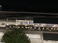 North Springs MARTA Station overlooking GA 400
 -
 MARTA Bus Stop on Roswell Road


Police and fire
editThe Sandy Springs Police Department is the city's police department[74]and took over services from Fulton County in 2006, with 86 original police officers recruited from various police agencies from all over the State of Georgia. The department 149 full-time sworn officers, 11 part-time officers, and 23 civilians. The department answered 124,374 calls for service and made 3,390 arrests in 2020.
The city's fire department began operations in 2006. The department consists of 113 full-time firefighters, and handled 17,000 responses to 8,205 calls for service.
References
edit- ^abcU.S. Geological Survey Geographic Names Information System: Sandy Springs, Georgia
- ^abDaughters of the American Revolution, Sandy Springs Chapter (2010)."City of Sandy Springs - From the Daughters of the American Revolution, Sandy Springs Chapter".City of Sandy Springs. Archived fromthe originalon July 30, 2010.RetrievedJuly 27,2010.
- ^City of Sandy Springs (2010)."City of Sandy Springs - Mayor's Office".Archived fromthe originalon July 15, 2010.RetrievedJuly 27,2010.
- ^"2020 U.S. Gazetteer Files".United States Census Bureau.RetrievedDecember 18,2021.
- ^United States Postal Service (2012)."USPS - Look Up a ZIP Code".RetrievedFebruary 15,2012.
- ^"QuickFacts: Sandy Springs city, Georgia".United States Census Bureau.RetrievedOctober 15,2021.
- ^abcdefgh"Sandy Springs GA History".SandySprings.Archived fromthe originalon July 29, 2010.RetrievedJune 14,2020.
- ^"Sandy Springs GA History".visitsandysprings.org.RetrievedMarch 3,2022.
- ^abKruse, Kevin Michael (2007).White flight: Atlanta and the making of modern conservatism.Princeton, N.J.: Princeton University Press.ISBN9781400848973.OCLC852159650.
- ^"City History".sandyspringsga.gov.RetrievedJune 28,2024.
- ^abcRosen, Sam (April 26, 2017)."Atlanta's Controversial 'Cityhood' Movement".The Atlantic.ISSN1072-7825.Archivedfrom the original on June 14, 2020.RetrievedJune 14,2020.
- ^Bragg, Rick (January 17, 1997)."2 Bomb Blasts Rock Abortion Clinic at Atlanta; 6 Are Injured".The New York Times.ISSN0362-4331.RetrievedJune 12,2020.
- ^Bonvillian, Crystal (March 19, 2018)."Serial bomber Eric Rudolph targeted Olympics, gay club, abortion clinics".Atlanta Journal-Constitution.RetrievedJune 12,2020.
- ^Wilkinson, Joe; Willard, Wendell; Geisinger, Harry; Lindsey, Edward (2005)."Georgia General Assembly - House Bill 37".Georgia General Assembly. Archived fromthe originalon July 30, 2010.RetrievedJuly 27,2010.
- ^abcdPaterson, Blake (September 19, 2019)."Why Sandy Springs, Georgia – once a model for St. George – has abandoned privatization".The Advocate.RetrievedJune 12,2020.
- ^"U.S. Reaches Agreements with Kings Mountain, N.C., and Sandy Springs, Ga., to Terminate Coverage from Preclearance of the Voting Rights Act".Justice.gov.September 22, 2010.RetrievedDecember 18,2012.
- ^abcArielle Kass, Ben Brasch (May 17, 2019)."Sandy Springs, First in Cityhood, Changes How it Does Business".The Atlanta Journal-Constitution.RetrievedMay 22,2019.
- ^Jamieson, Alastair (February 12, 2014)."'Catastrophic' ice storm hits Atlanta, threatening power lines ".CNBC.RetrievedJune 12,2020.
- ^"Average weather for Sandy Springs".Weather.RetrievedAugust 13,2009.
- ^abc"City Springs complex anchors new downtown for Sandy Springs".Atlanta Journal-Constitution.July 8, 2018.RetrievedJune 12,2020.
- ^"Sandy Springs Civic Roundtable - Neighborhood Profiles".Archived fromthe originalon August 26, 2010.
- ^"Fulton County Schools / Homepage".fultonschools.org.
- ^ab"Sandy Springs vetoes Dunwoody toppers - Dunwoody Crier: Local News".Thecrier.net. July 25, 2006.RetrievedDecember 18,2012.
- ^"About Perimeter CIDs - Perimeter Community Improvement Districts".Archived fromthe originalon September 6, 2012.
- ^"MARTA - Metropolitan Atlanta Rapid Transit Authority".Itsmarta.RetrievedDecember 18,2012.
- ^"northspringshigh".
- ^North Springs NeighborhoodArchivedAugust 22, 2011, at theWayback Machine
- ^ "Sandy Springs Public Schools".
- ^Osterman, Jim (September 3, 2010)."Sandy Springs: ITP snob appeal is s-o-o-o-o not funny".Atlanta Journal-Constitution.RetrievedJune 12,2020.
- ^"Navigating Atlanta Neighborhoods: ITP vs. OTP | | KNOWAtlanta".RetrievedJune 12,2020.
- ^"Sandy Springs Public Schools".RetrievedMarch 3,2022.
- ^"99X".RetrievedMarch 3,2022.
- ^"Sandy Springs' Powers Ferry Landing gets a place in the spotlight".April 17, 2016.
- ^"Decennial Census of Population and Housing by Decade".United States Census Bureau.
- ^"1870 Census of Population - Georgia - Population of Civil Divisions less than Counties"(PDF).United States Census Bureau.1870.
- ^"1880 Census of Population - Georgia - Population of Civil Divisions less than Counties"(PDF).United States Census Bureau.1880.
- ^"1910 Census of Population - Georgia"(PDF).United States Census Bureau.1910.
- ^"1930 Census of Population - Georgia"(PDF).United States Census Bureau.1930. pp.251–256.
- ^"1940 Census of Population - Georgia"(PDF).United States Census Bureau.1940.
- ^"1950 Census of Population - Georgia"(PDF).United States Census Bureau.1950.
- ^"1960 Census of Population - Population of County Subdivisions - Georgia"(PDF).United States Census Bureau.1960.
- ^ab"1970 Census of Population - Population of County Subdivisions - Georgia"(PDF).United States Census Bureau.1970.
- ^ab"1980 Census of Population - Number of Inhabitants - Georgia"(PDF).United States Census Bureau.1980.
- ^"1990 Census of Population - Summary Social, Economic, and Housing Characteristics - Georgia"(PDF).United States Census Bureau.1990.
- ^ab"2000 Census of Population - General Population Characteristics - Georgia"(PDF).United States Census Bureau.2000.
- ^"2010 Census of Population - General Population Characteristics - Georgia"(PDF).United States Census Bureau.2010.
- ^ab"P2 Hispanic or Latino, and Not Hispanic or Latino by Race – 2020: DEC Redistricting Data (PL 94-171) – Sandy Springs city, Georgia".United States Census Bureau.
- ^"P004 Hispanic or Latino, and Not Hispanic or Latino by Race – 2000: DEC Summary File 1 – Sandy Springs CDP, Georgia".United States Census Bureau.
- ^ab"P2 Hispanic or Latino, and Not Hispanic or Latino by Race – 2010: DEC Redistricting Data (PL 94-171) – Sandy Springs city, Georgia".United States Census Bureau.
- ^"American FactFinder - Results".factfinder.census.gov.U.S. Census Bureau. Archived fromthe originalon February 12, 2020.RetrievedApril 28,2009.
- ^"Sandy Springs, GA".
- ^"Mercedes-Benz USA Celebrates Grand Opening of New Headquarters".March 15, 2018.
- ^"City of Sandy Springs, GA ACFR"(PDF).sandyspringsga.org.RetrievedJanuary 16,2023.
- ^"Sandy Springs Festival".
- ^"Sandy Springs Artsapalooza".
- ^"Sandy Springs, GA".
- ^"Sandy Springs Branch."Atlanta-Fulton Public Library System.Retrieved on February 24, 2010.
- ^"Sandy Springs, GA".
- ^Feine, Paul."Sandy Springs, Georgia: The city that outsourced everything".ReasonTV. Reason Foundation.Archivedfrom the original on December 11, 2021.RetrievedDecember 29,2017.
- ^Segal, David (June 23, 2012)."A Georgia Town Takes the People's Business Private".The New York Times.
- ^"Public Private Partnership".March 3, 2022.
- ^Northam, Mitchell (April 4, 2018)."New city hall in Sandy Springs set to open in May".The Atlanta Journal-Constitution.
- ^"Sandy Springs Elementary School Attendance Boundaries School Year 2009–2010Archived2011-07-18 at theWayback Machine."Fulton County School System.Accessed October 26, 2008.
- ^"Home".St. Jude the Apostle Catholic School.RetrievedMarch 11,2020.
7171 Glenridge Drive NE, Atlanta, GA 30328
- Address says "Atlanta, GA" but it is in the Sandy Springs city limits - ^"History and Mission".St. Jude the Apostle Catholic School.RetrievedMarch 11,2020.
- ^"Contact Us."Holy Spirit Preparatory School.Retrieved on January 7, 2019. "Upper School Campus 4449 Northside Drive Atlanta, GA 30327" and "Lower School Campus 4820 Long Island Drive Atlanta, GA 30342" and "Preschool Campus 4465 Northside Drive Atlanta, GA 30327"
- ^"Zoning."City of Sandy Springs. Retrieved on January 7, 2019.
- ^ab"History".Sophia Academy. Archived fromthe originalon June 19, 2016.RetrievedMay 12,2020.
- ^"Home".Sophia Academy. November 1, 2004. Archived fromthe originalon November 1, 2004.RetrievedMay 12,2020.
650 Mt. Vernon Road, Atlanta, Georgia 30238
- ^"Zoning Map"(PDF).Sandy Springs, Georgia. January 1, 2007. Archived fromthe original(PDF)on January 1, 2007.RetrievedMay 12,2020.
- ^"Reporter Newspapers".
- ^"AJC: Atlanta News, Sports, Atlanta Weather, Business News".
- ^"Capital Improvement Projects".Archived fromthe originalon January 29, 2011.
- ^"Sandy Springs Police Department".
Further reading
editCensus-designated place maps:
- 2000 U.S. Census:Index mapandlink to pages
- 1990 U.S. Census:Fulton County index map,with Sandy Spring on pages 12-13, 17-19, and 20-22,link to pages