This articleneeds additional citations forverification.(December 2023) |
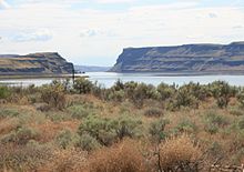
Awater gapis agapthat flowing water has carved through amountain rangeormountain ridgeand that still carries water today.[1]Such gaps that no longer carry water currents are calledwind gaps.Water gaps and wind gaps often offer a practical route forroadandrail transportto cross the mountain barrier.

Geology
editA water gap is usually an indication of ariverthat is older than the current topography. The likely occurrence is that a river established its course when the landform was at a low elevation, or by a rift in a portion of the crust of the earth having a very lowstream gradientand a thick layer of unconsolidatedsediment.
In a hypothetical example, a river would have established its channel without regard for the deeper layers ofrock.A later period ofupliftwould cause increasederosionalong the riverbed, exposing the underlying rock layers. As the uplift continued, the river, being large enough, would continue to erode the rising land, cutting through ridges as they formed.
Water gaps are common in theRidge-and-Valley Appalachiansof easternNorth America.
Alternatively, a water gap may be formed throughheadward erosionof two streams on opposite sides of a ridge, ultimately resulting in thecaptureof one stream by the other.
Notable examples
edit- Chicago Portage,Illinois-Saddle Pointruns through the city itself.
- Columbia River Gorge,Oregon and Washington, andWallula Gap,Washington, United States
- Cumberland Narrows,Maryland, United States
- Delaware Water Gap,New Jersey and Pennsylvania, United States[2]
- Heavitree Gap,Alice Springs, Australia
- Iron Gateson the Danube River, forming the border between Serbia and Romania
- Kali Gandaki Gorge- cuts through the world's tallest mountain range, theHimalayasin Nepal
- Manawatū Gorge,New Zealand
- Middle Rhinein Germany
- Pongo de Mainique,Peru - on theUrubamba River
- Pongo de Manseriche,Peru - on theMarañón River
- Potomac Water Gap,United States
- Weltenburg Narrowson theDanube Riverin Bavaria
- Wawa Gorge,Rodriguez,Rizal,Philippines
References
edit- ^Creation Research Society (2010).Creation Research Society Quarterly Vol. 47 No. 1 Summer 2010.
- ^"Delaware Water Gap".National Park Service.Retrieved23 December2023.
See also
edit