Żerań

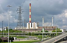
Żerańis a northern suburb ofWarsaw,Poland, situated in theBiałołękadistrict. It is noted for theŻerań Power Station.The area borders with theVistula River,thePraga-Północdistrict and theTarchomin,Różopol,KonstantynówandAnnopolhousing estates.[citation needed]
History
[edit]Żerań was first mentioned in the fourteenth century. The name comes from the old Polish terms "żyr" or "żer" and means "pasture in the forest".[1]

In the western side of Żerań is the housing estate Piekiełko at52°18′32″N20°58′42″E/ 52.30889°N 20.97833°E,which includes the Kasztanowa, Płużnicka and Ekspresowa streets. It was founded in the second half of the 19th century along the present Modlińska Street. By 1887, 51 houses were erected here. 58 people were recorded in the 1912 census.[2]The Jabłonowska Railway, which ran toJabłonnain 1900–1956 (with breaks in 1939 and 1944) contributed to the development of the settlement. The railway was instrumental in transporting goods from the Spiess chemical (later pharmaceutical) factory inTarchomin(now Polfa Tarchomin SA) and the chemical factory "Winnica" inHenryków.[3]During the German occupation, a Jewish labor camp operated in Piekiełka. It was liquidated in November 1942.[4]Piekiełko was annexed to Warsaw together with other neighboring villages in 1951.[citation needed]
Economy
[edit]
The Żerań estate mainly has industrial functions. It contains apower plant,which began operations in 1954,[5]a furnace waste dump, numerous office buildings and warehouses,[6]a glass hardening factory, manufacturer H + H Poland, and the Żerański Canal and port.[7]During the People's Republic of Poland, the Faelbe Concrete Element Factory operated in Żerań.[8]
References
[edit]- ^Handke, Kwiryna (2011).Dzieje Warszawy nazwami pisane(in Polish). Warsaw: Muzeum Historyczne m.st. Warszawy. p. 327.ISBN978-83-62189-08-3.
- ^Encyklopedia Warszawy(in Polish). Wydawnictwo Naukowe PWN.ISBN83-01-08836-2.
- ^"Źródło: Bogdan Pokropiński" Kolej jabłonowska "".Trasbus.com(in Polish).
- ^Pilichowski, Czesław (1979).Obozy hitlerowskie na ziemiach polskich 1939–1945. Informator encyklopedyczny(in Polish). Państwowe Wydawnictwo Naukowe.ISBN83-01-00065-1.
- ^"Our Plants"(in Polish). PGNiG Termika.Retrieved10 February2020.
- ^"Warszawa, Żerań".warszawa.nieruchomosci-online.pl(in Polish).Retrieved10 February2020.
- ^Google Maps
- ^Kasprzycki, Jerzy (1980).Warszawa-Praga(in Polish). Warsaw: Krajowa Agencja Wydawnicza. p. 42.
