
Colaba
Colaba
Kolābā | |
|---|---|
Neighbourhood | |
 Colaba | |
| Coordinates:18°55′N72°49′E/ 18.91°N 72.81°E | |
| Country | India |
| State | Maharashtra |
| District | Mumbai City |
| City | Mumbai |
| Zone | 1 |
| Ward | A |
| Government | |
| • Type | Municipal Corporation |
| • Body | Brihanmumbai Municipal Corporation(BMC) |
| Elevation | 4 m (13 ft) |
| Languages | |
| • Official | Marathi |
| Time zone | UTC+5:30(IST) |
| PIN | 400005[1] |
| Area code | 022 |
| Vehicle registration | MH 01 |
| Lok SabhaConstituency | Mumbai South |
| Vidhan SabhaConstituency | Colaba |
| Civic agency | BMC |
Colaba([koˈlaːbaː];orISO:Kolābā)is a part of the city ofMumbai,India. It is one of the four peninsulas of Mumbai while the other three areWorli,BandraandMalabar Hill.During Portuguese rule in the 16th century, the island was known as Kolbhat. After the British took over the island in the late 17th century, it was known as Kolio.[citation needed]

History
[edit]
The name Colaba comes fromKolabhat,a word in the language ofKolis,the indigenous inhabitants of the islands, before the arrival of the Portuguese.[2]The area that is now Colaba was originally a region consisting of two islands: Colaba and Little Colaba (orOld Woman's Island). The island of Colaba was one of theSeven Islands of Mumbairuled by thePortuguese.
The Portuguese had acquired these lands from theSultanate of Cambayby theTreaty of Vasai (1534).The group of islands was given by Portugal toCharles II of Englandas a dowry when he marriedCatherine of Braganzain 1661. The cession of Mumbai and dependencies was strongly resented by Portuguese officials inGoaand Mumbai, who resisted transfer of possession for several years, while the English representatives were confined to the island ofAnjedivawhile negotiations continued. Angered by the back-tracking, Charles II leased these lands to theBritish East India Companyfor a nominal annual rent.Gerald Aungier,second Governor (1672), and the president of the English settlement ofSurat,took possession of Colaba andOld Woman's Islandon behalf of the Company in 1675.
Portugal continued to hold Little Colaba island for several decades more before ceding it to the English in about 1762, subject to the retention of Portuguese ownership of a house on the island, that is now the Blessed Sacrament Chapel in Middle Colaba. This was leased by the Portuguese Government of Goa to theBishop of Damao,the head of thePadroadoparty in Mumbai, as his residence. After an attempt by thePropaganda Fideparty to seize the chapel, a court ruled that the house remained the property of the Government of Portugal and evicted the Propaganda Fide party.


In 1743, British Colaba was leased toRichard Broughtonat Rs. 200 yearly, and the lease was renewed in 1764.[4]By 1796, Colaba had become a cantonment. Colaba was known for the variety of fishes – thebombil(Bombay duck),rawas,halwa,turtles, crabs, prawns and lobsters.
AColaba Observatory,ameteorologicalobservatorywas established in 1826 in the part that was called Upper Colaba. TheColaba Causewaywas completed in 1838, and thus, the remaining two islands were joined to the others. Gradually, Colaba became a commercial center, after the Cotton Exchange was opened atCotton Greenin 1844. The real estate prices in the area went up. The Colaba Causeway was widened in 1861 and 1863.

Colaba became a separate municipality ward in 1872. The Sick Bungalows (now known as INHS Asvini) were built in the 19th century. The construction of theAfghan Churchafter theFirst Afghan Warof 1838) began in 1847. The Church was consecrated in 1858, with the work on thesteeplebeing concluded in 1865.
The horse-drawn tram-cars were introduced in 1873 byStearns and Kitteredge,who had their offices on the west side of the Causeway, where the Electric House now stands.
The Prong's lighthouse was constructed at the southern tip of the island in 1875. The eponymousSassoon Dockswere built byDavid Solomon Sassoonon reclaimed land in the same year. The BB&CI Railways established theColaba railway stationorterminus,the site of which is now occupied by theBadhwar Parklayout. The development of Colaba pushed the nativekolisto the edges of the island.
TheMumbai City Improvement Trustreclaimed around 90,000 square yards (75,000 m2) on the western shore of Colaba. Eminent citizens of Mumbai, such as SirPherozeshah Mehta,opposed the work, fearing that the reclamation would depress prices of land. However, the reclamation work continued and was completed in 1905. There was no fall in the land prices. In 1906, a seafront road with a raised sea-side promenade was completed, and named as "Cuffe Parade"after T. W. Cuffe of the Trust.
Present day
[edit]TheGateway of India,theart decostyle Regal Theatre, the cafes (Café Mondegar,Cafe Royal andLeopold Cafe), and theTaj Mahal Palace & Tower,Royal Bombay Yacht Club,Bademiya Restaurant and Bagdadi restaurant, as well as a number of modern pubs, restaurants and clubs all add to the atmosphere. The southern tip is occupied by a military cantonment, including the largeNavy Nagarlayout built on reclaimed land known as Holiday Camp. The older parts of the cantonment retains its large, wooded spaces and is the only bit of green left in this otherwise congested area. In the midst of Navy Nagar lies theTata Institute of Fundamental Research(TIFR), one of India's leading scientific institutions. Colaba is renowned for high-end boutiques and imitation consumer goods, and is popular with tourists. Notable residents includeRatan Tata,Anil Ambani,andRavi Shastri.Colaba Causeway, or just "Causeway" as it is known in Mumbai, offers everything from bracelets to perfumes to clothes to watches, clocks, DVDs and CDs. It has an old English charm and a very modern feel as well. Colaba is also the art center of Mumbai, with all the major galleries and museums located in and around this area.[5]Even today, in 2020, the government has managed to preserve most of its colonial-era architectures.

Colaba is home to theCooperage Football Ground.
Transport
[edit]Nearest railway stations:
- Churchgate
- Chhatrapati Shivaji Maharaj Terminus( "CSMT", Victoria Terminus)
Visitor attractions
[edit]- Colaba Causeway
- Colaba Observatory
- Cowasji Jehangir Hall
- Ballard Estate
- Cathedral of the Holy Name
- Prong's Lighthouse
- Gateway of India
- Sassoon Docks
- David Sassoon Library
Gallery
[edit]-
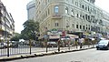 Cafe Mondegar on Colaba Causeway
 -
 Colaba Apartments
 -
 Colaba Causeway construction, view from Colaba island, 1826


Terrorist attack in November 2008
[edit]On 26 November 2008, terrorist strikes occurred at various places in and near Colaba, notably theTaj Mahal Palace & Tower,Leopold Café,Marine DriveandMumbai Chabad House.The attacks resulted in over 100 deaths and significant damages.
See also
[edit]- Colaba Woods
- Other business districts in and around Mumbai:Fort,Nariman Point,Vashi,CBD Belapur,Worli,Bandra Kurla Complex,Andheri,Lower Parel
References
[edit]- ^"Pin code: Colaba, Mumbai".indiapincodes.net.Retrieved9 February2015.
- ^"Google Groups".bbs.keyhole.com.Retrieved18 August2017.[permanent dead link]
- ^Clutterbuck, G W (1889)."A Sketch of the Mission in Bombay".Wesleyan-Methodist Magazine:199.Retrieved3 November2015.
- ^Gupta, Sourendu (28 October 1999)."Colaba, Cuffe Parade and Navy Nagar: Mumbai/Bombay pages".theory.tifr.res.in.Retrieved18 August2017.
- ^"Colaba: Latest News, Videos and Photos - Times of India".The Times of India.Retrieved18 August2017.
External links
[edit]| Pre-colonial | |
|---|---|
| Colonial | |
| Beaches | |
| Places of worship | |
| Cultural | |
| Boulevards | |
| Districts | |
| Shopping | |
| Buildings | |
| Parks, zoos and stadia | |
| Museums | |
| Forts | |
| Restaurants & bars | |


