
Central, Minneapolis
Central | |
|---|---|
 Location of Central Minneapolis inMinneapolis | |
| Country | United States |
| State | Minnesota |
| County | Hennepin |
| City | Minneapolis |
| Founded | 1849 |
| City Council Wards | 3, 5, 6, 7 |
| Neighborhoods | |
| Government | |
| • Council Member | Michael Rainville |
| • Council Member | Jeremiah Ellison |
| • Council Member | Jamal Osman |
| • Council Member | Katie Cashman |
| Area | |
| • Total | 3.024 sq mi (7.83 km2) |
| Population (2023)[3] | |
| • Total | 58,409[2] |
| • Density | 19,315/sq mi (7,458/km2) |
| Time zone | UTC-6(CST) |
| • Summer (DST) | UTC-5(CDT) |
| ZIP Code | 55401, 55402, 55403, 55404, 55405, 55411, 55415, 55454, 55487 |
| Area code | 612 |
| Census | Pop. | Note | %± |
|---|---|---|---|
| 1980 | 18,952 | — | |
| 1990 | 21,158 | 11.6% | |
| 2000 | 24,149 | 14.1% | |
| 2010 | 29,725 | 23.1% | |
| 2020 | 53,093 | 78.6% | |
| 2023 (est.) | 58,409 | [2] | 10.0% |

Centralis a defined community inMinneapolisthat consists of six smaller official neighborhoods around the downtown and central business core. It also includes the many oldflour mills,theMill District,and other historical and industrial areas of downtown Minneapolis. It also includes some high-density residential areas surrounding it, excluding areas east of theMississippi River.Businesses and government buildings are based in the Central area include the corporate headquarters of theStar Tribune,Target,US Bancorp,theHennepin County Government Center,Minneapolis Central Library,Minneapolis City Hall,and the broadcast facilities of the MinnesotaCBSstationWCCO-TV.
There is no City Council ward representing the majority of Central Minneapolis. It is split between Wards 3, 5, 6, and 7,[4]represented by Council MembersRainville,Ellison,Osman,andCashmanrespectively.
Central neighborhoods
[edit]- Downtown East
- Downtown West
- Elliot Park
- Loring Park
- North Loop,commonly referred to as the Warehouse District
- Stevens Square/Loring Heights
44°58′35″N93°16′26″W/ 44.9763°N 93.2739°W[5]
Gallery
[edit]-
 View of downtown Minneapolis from theStone Arch Bridge.
 -
 Downtown Minneapolis panorama
 -
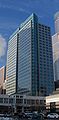
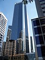 WhiteU.S. Bancorptowers reflected in theCapella Tower.
 -
 Downtown Minneapolis fromBde Maka Ska.
 -
 Minneapolis Skyline fromTarget Field.
 -
-
 Wells Fargo Centerfrom theFoshay Tower
 -

-
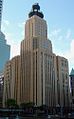
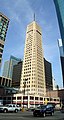 TheFoshay Tower
 -
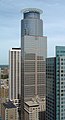
 33 South Sixth,also known as the City Center.
 -
 Target Plaza South,the headquarters ofTarget Corporation,lit up multicolored during the winter.
 -

-

-
-
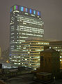
 TheHennepin County Government Center,the site of the Occupy Minnesota protests.
 -
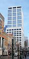
 TheCenturyLink Building,the 17th tallest building inMinneapolis.
 -
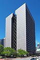
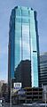
 US Bank Plaza,the 6th tallest building in Minneapolis.
 -

-
-

-


See also
[edit]References
[edit]- ^"Greater Central neighborhood in Minneapolis, Minnesota (MN), 55401, 55402, 55403, 55404, 55415 detailed profile".City-Data.2011.Retrieved2013-11-12.
- ^ab"Downtown Minneapolis Population Grew 2.9% in 2023".7 February 2024.
- ^"Minneapolis Community Profile: Central"(PDF).Minnesota Compass. October 2011.Retrieved2013-11-12.
- ^"Find My Ward".City of Minneapolis.Retrieved19 April2024.
- ^Central, Minneapolis, MN.Google Earth.Retrieved 2011-03-09.