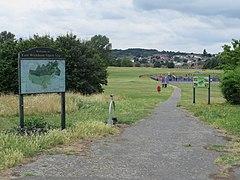
East Wickham
| East Wickham | |
|---|---|
 East Wickham Open Space | |
Location withinGreater London | |
| Area | 0.83 sq mi (2.1 km2) |
| Population | 10,858 (2011)[1] |
| •Density | 13,082/sq mi (5,051/km2) |
| OS grid reference | TQ455765 |
| •Charing Cross | 10.5 mi (16.9 km)WNW |
| London borough | |
| Ceremonial county | Greater London |
| Region | |
| Country | England |
| Sovereign state | United Kingdom |
| Post town | WELLING |
| Postcode district | DA16 |
| Dialling code | 020 |
| Police | Metropolitan |
| Fire | London |
| Ambulance | London |
| UK Parliament | |
| London Assembly | |
East Wickhamis a district in south-eastLondon,England, within theLondon Borough of Bexley.It is situated north ofWelling,east ofShooter's Hill,south ofPlumstead,south-west ofAbbey Woodand west ofWest Heath,and 10.5 miles (16.9 km) east-southeast ofCharing Cross.Prior to the creation ofGreater Londonin 1965, East Wickham was in theadministrative countyofKent.
History
[edit]The name is thought to be a corruption of theLatin'vicus', indicating aRoman settlementalongWatling Street,with the place name 'Estwycham' first being recorded in 1284.[2]The 'east' was added to differentiate it fromWest Wickham,situated some distance away to the south-west.[2]
The larger settlement ofWellingoriginally formed part of the ancient manor of East Wickham, which was centred on St Michael's Church,Upper Wickham Lane,built in the 13th century.[2]In theDomesday Book(1086) East Wickham was included as part of the return for Plumstead and the church was originally a chapel of St Nicholas’ Church inPlumstead,within theLittle and Lesnes Hundred.[3]It became a civil parish in its own right in 1854 and formed part ofDartford Rural Districtfrom 1894. It ceased to be a civil parish and was absorbed by theBexley Urban Districton 1 October 1902.[4]The area was largely rural in character until the early 20th century, with large scale house building beginning in the area from 1916 onwards.[2]
Transport
[edit]SeveralTransport for Londonbus services connect East Wickham with areas includingWelling,Eltham,Bexleyheath,Plumstead,Woolwich,Abbey Wood,North Greenwich,ThamesmeadandDartford.The nearest rail link to the area isWelling railway station.
Notable residents
[edit]References
[edit]- ^"East Wickham Ward - Local Area Report".Nomis.Office for National Statistics.Retrieved4 January2021.
- ^abcdeWilley, Russ.Chambers London Gazetteer,p 156
- ^"East Wickham | The Environs of London: volume 4 (pp. 546-549)".British-history.ac.uk. 22 June 2003.Retrieved25 August2014.
- ^"East Wickham CP/Ch through time | Census tables with data for the Parish-level Unit".Visionofbritain.org.uk. 1 October 1902.Retrieved25 August2014.


