
Geography
| Part of a series on |
| Geography |
|---|
 |
Geography(fromAncient Greekγεωγραφίαgeōgraphía;combininggê'Earth' andgráphō'write') is the study of the lands, features, inhabitants, and phenomena ofEarth.[1]Geography is an all-encompassing discipline that seeks an understanding of Earth andits human and natural complexities—not merely where objects are, but also how they have changed and come to be. While geography is specific to Earth, manyconceptscan be applied more broadly to othercelestial bodiesin the field ofplanetary science.[2]Geography has been called "a bridge betweennatural scienceandsocial sciencedisciplines. "[3]
Origins of many of the concepts in geography can be traced to GreekEratosthenesof Cyrene, who may have coined the term "geographia" (c. 276 BC– c. 195/194 BC).[4]The first recorded use of the wordγεωγραφίαwas as the title of a book by Greek scholarClaudius Ptolemy(100 – 170 AD).[1]This work created the so-called "Ptolemaic tradition" of geography, which included "Ptolemaic cartographic theory."[5]However, the concepts of geography (such ascartography) date back to the earliest attempts to understand the world spatially, with the earliest example of an attempted world map dating to the 9th century BCE in ancientBabylon.[6]Thehistory of geographyas a discipline spans cultures and millennia, being independently developed by multiple groups, and cross-pollinated by trade between these groups. The core concepts of geography consistent between all approaches are a focus on space, place, time, and scale.[7][8][9][10][11][12]
Today, geography is an extremely broad discipline with multiple approaches and modalities. There have been multiple attempts to organize the discipline, including the four traditions of geography, and into branches.[13][3][14]Techniques employed can generally be broken down intoquantitative[15]andqualitative[16]approaches, with many studies takingmixed-methodsapproaches.[17]Common techniques includecartography,remote sensing,interviews,andsurveying.
Fundamentals


Geography is a systematic study of the Earth (other celestial bodies are specified, such as "geography of Mars", or given another name, such asareographyin the case of Mars), its features, and phenomena that take place on it.[18][19][20]For something to fall into the domain of geography, it generally needs some sort of spatial component that can be placed on amap,such ascoordinates,place names, oraddresses.This has led to geography being associated withcartographyand place names. Although many geographers are trained intoponymyand cartology, this is not their main preoccupation.Geographersstudy the Earth's spatial and temporal distribution of phenomena, processes, and features as well as the interaction of humans and theirenvironment.[21]Because space and place affect a variety of topics, such as economics, health,climate,plants, and animals, geography is highly interdisciplinary. The interdisciplinary nature of the geographical approach depends on an attentiveness to the relationship between physical and human phenomena and their spatial patterns.[22]
Names of places...are not geography...To know by heart a whole gazetteer full of them would not, in itself, constitute anyone a geographer. Geography has higher aims than this: it seeks to classify phenomena (alike of the natural and of the political world, in so far as it treats of the latter), to compare, to generalize, to ascend from effects to causes, and, in doing so, to trace out the laws of nature and to mark their influences upon man. This is 'a description of the world'—that is Geography. In a word, Geography is a Science—a thing not of mere names but of argument and reason, of cause and effect.[23]
— William Hughes,1863
Geography as a discipline can be split broadly into three main branches:human geography,physical geography,andtechnical geography.[3][24]Human geography largely focuses on thebuilt environmentand how humans create, view, manage, and influence space.[24]Physical geography examines the natural environment and howorganisms,climate,soil,water, andlandformsproduce and interact.[25]The difference between these approaches led to the development ofintegrated geography,which combines physical and human geography and concerns the interactions between the environment and humans.[21]Technical geography involves studying and developing the tools and techniques used by geographers, such as remote sensing, cartography, and geographic information system.[26]
Key concepts
Narrowing down geography to a few key concepts is extremely challenging, and subject to tremendous debate within the discipline.[27]In one attempt, the 1st edition of the book "Key Concepts in Geography" broke down this into chapters focusing on "Space," "Place," "Time," "Scale," and "Landscape."[28]The 2nd edition of the book expanded on these key concepts by adding "Environmental systems," "Social Systems," "Nature," "Globalization,""Development, "and" Risk, "demonstrating how challenging narrowing the field can be.[27]

Another approach used extensively in teaching geography are theFive themes of geographyestablished by "Guidelines for Geographic Education: Elementary and Secondary Schools," published jointly by theNational Council for Geographic Educationand theAssociation of American Geographersin 1984.[29][30]These themes are Location, place, relationships within places (often summarized as Human-Environment Interaction), movement, and regions.[30][31]The five themes of geography have shaped how American education approaches the topic in the years since.[30][31]
Space

Just as all phenomena exist in time and thus have a history, they also exist in space and have a geography.[32]
For something to exist in the realm of geography, it must be able to be described spatially.[32][33]Thus, space is the most fundamental concept at the foundation of geography.[7][8]The concept is so basic, that geographers often have difficulty defining exactly what it is.Absolute spaceis the exact site, or spatial coordinates, of objects, persons, places, or phenomena under investigation.[7]We exist in space.[9]Absolute space leads to the view of the world as a photograph, with everything frozen in place when the coordinates were recorded. Today, geographers are trained to recognize the world as a dynamic space where all processes interact and take place, rather than a static image on a map.[7][34]
Place

Place is one of the most complex and important terms in geography.[9][10][11][12]In human geography, place is the synthesis of the coordinates on the Earth's surface, the activity and use that occurs, has occurred, and will occur at the coordinates, and the meaning ascribed to the space by human individuals and groups.[33][11]This can be extraordinarily complex, as different spaces may have different uses at different times and mean different things to different people. In physical geography, a place includes all of the physical phenomena that occur in space, including thelithosphere,atmosphere,hydrosphere,andbiosphere.[12]Places do not exist in a vacuum and instead have complex spatial relationships with each other, and place is concerned how a location is situated in relation to all other locations.[36][37]As a discipline then, the term place in geography includes all spatial phenomena occurring at a location, the diverse uses and meanings humans ascribe to that location, and how that location impacts and is impacted by all other locations on Earth.[11][12]In one ofYi-Fu Tuan's papers, he explains that in his view, geography is the study of Earth as a home for humanity, and thus place and the complex meaning behind the term is central to the discipline of geography.[10]
Time

Time is usually thought to be within the domain ofhistory,however, it is of significant concern in the discipline of geography.[38][39][40]In physics, space and time are not separated, and are combined into the concept ofspacetime.[41] Geography is subject to the laws of physics, and in studying things that occur in space, time must be considered. Time in geography is more than just the historical record of events that occurred at various discrete coordinates; but also includes modeling the dynamic movement of people, organisms, and things through space.[9]Time facilitates movement through space, ultimately allowing things to flow through a system.[38]The amount of time an individual, or group of people, spends in a place will often shape their attachment and perspective to that place.[9]Time constrains the possible paths that can be taken through space, given a starting point, possible routes, and rate of travel.[42]Visualizing time over space is challenging in terms of cartography, and includes Space-Prism, advanced 3D geovisualizations, andanimated maps.[36][42][43][34]
Scale

Scale in the context of a map is the ratio between a distance measured on the map and the corresponding distance as measured on the ground.[2][44]This concept is fundamental to the discipline of geography, not just cartography, in that phenomena being investigated appear different depending on the scale used.[45][46]Scale is the frame that geographers use to measure space, and ultimately to try and understand a place.[44]
Laws of geography
During the quantitative revolution, geography shifted to an empirical law-making (nomothetic) approach.[47][48]Severallaws of geographyhave been proposed since then, most notably byWaldo Toblerand can be viewed as a product of the quantitative revolution.[49]In general, some dispute the entire concept of laws in geography and the social sciences.[36][50][51]These criticisms have been addressed by Tobler and others, such asMichael Frank Goodchild.[50][51]However, this is an ongoing source of debate in geography and is unlikely to be resolved anytime soon. Several laws have been proposed, and Tobler's first law of geography is the most generally accepted in geography. Some have argued that geographic laws do not need to be numbered. The existence of a first invites a second, and many have proposed themselves as that. It has also been proposed that Tobler's first law of geography should be moved to the second and replaced with another.[51]A few of the proposed laws of geography are below:
- Tobler's first law of geography:"Everything is related to everything else, but near things are more related than distant."[36][50][51]
- Tobler's second law of geography:"The phenomenon external to a geographic area of interest affects what goes on inside."[50][52]
- Arbia's law of geography:"Everything is related to everything else, but things observed at a coarse spatial resolution are more related than things observed at a finer resolution."[45][50][46][53][54]
- Spatial heterogeneity:Geographic variables exhibit uncontrolled variance.[51][55][56]
- The uncertainty principle: "That the geographic world is infinitely complex and that any representation must therefore contain elements of uncertainty, that many definitions used in acquiring geographic data contain elements of vagueness, and that it is impossible to measure location on the Earth's surface exactly."[51]
Additionally, several variations or amendments to these laws exist within the literature, although not as well supported. For example, one paper proposed an amended version of Tobler's first law of geography, referred to in the text as theTobler–von Thünen law,[49]which states: "Everything is related to everything else, but near things are more related than distant things,as a consequence of accessibility."[Note 1][49]
Sub-disciplines
Geography is a branch of inquiry that focuses on spatial information on Earth. It is an extremely broad topic and can be broken down multiple ways.[14]There have been several approaches to doing this spanning at least several centuries, including "four traditions of geography" and into distinct branches.[57][13]The Four traditions of geography are often used to divide the different historical approach theories geographers have taken to the discipline.[13]In contrast, geography's branches describe contemporary applied geographical approaches.[3]
Four traditions
Geography is an extremely broad field. Because of this, many view the various definitions of geography proposed over the decades as inadequate. To address this,William D. Pattisonproposed the concept of the "Four traditions of Geography" in 1964.[13][58][59]These traditions are theSpatialor Locational Tradition, the Man-Land or Human-Environment Interaction Tradition (sometimes referred to asIntegrated geography), theArea StudiesorRegionalTradition, and theEarth ScienceTradition.[13][58][59]These concepts are broad sets of geography philosophies bound together within the discipline. They are one of many ways geographers organize the major sets of thoughts and philosophies within the discipline.[13][58][59]
Branches
In another approach to the abovementioned four traditions, geography is organized into applied branches.[60][61]TheUNESCOEncyclopedia of Life Support Systemsorganizes geography into the three categories ofhuman geography,physical geography,andtechnical geography.[3][62][60][14]Some publications limit the number of branches to physical and human, describing them as the principal branches.[33]Geographers rarely focus on just one of these topics, often using one as their primary focus and then incorporating data and methods from the other branches. Often, geographers are asked to describe what they do by individuals outside the discipline[10]and are likely to identify closely with a specific branch, or sub-branch when describing themselves to lay people. Human geography studies people and their communities, cultures, economies, and environmental interactions by studying their relations with and across space and place.[33]Physical geography is concerned with the study of processes and patterns in the natural environment like theatmosphere,hydrosphere,biosphere,andgeosphere.[33]Technical geographyis interested in studying and applying techniques and methods to store, process, analyze, visualize, and use spatial data.[61]It is the newest of the branches, the most controversial, and often other terms are used in the literature to describe the emerging category. These branches use similar geographic philosophies, concepts, and tools and often overlap significantly.
Physical
Physical geography (or physiography) focuses on geography as anEarth science.[63][64][65]It aims to understand the physical problems and the issues oflithosphere,hydrosphere,atmosphere,pedosphere,and globalfloraandfaunapatterns (biosphere). Physical geography is the study of earth's seasons,climate,atmosphere,soil,streams, landforms, and oceans.[66]Physical geographers will often work in identifying and monitoring the use of natural resources.
- Physical geography can be divided into many broad categories, including:
-
-
-

-
-

-
-
-

-

-

-
-


Human
Human geography (or anthropogeography) is a branch of geography that focuses on studying patterns and processes that shape human society.[67]It encompasses the human, political,cultural,social, and economic aspects. In industry, human geographers often work in city planning, public health, or business analysis.
- Human geography can be divided into many broad categories, such as:
-

-

-
-

-

-
-

-
-
-

-

-
-
-


Various approaches to the study of human geography have also arisen through time and include:
Technical
Technical geography concerns studying and developing tools, techniques, and statistical methods employed to collect, analyze, use, and understand spatial data.[26][3][60][62]Technical geography is the most recently recognized, and controversial, of the branches. Its use dates back to 1749, when a book published byEdward Caveorganized the discipline into a section containing content such as cartographic techniques and globes.[57]There are several other terms, often used interchangeably with technical geography to subdivide the discipline, including "techniques of geographic analysis,"[68]"Geographic Information Technology,"[1]"Geography method's and techniques,"[69]"Geographic Information Science,"[70]"geoinformatics,""geomatics,"and" information geography ". There are subtle differences to each concept and term; however, technical geography is one of the broadest, is consistent with the naming convention of the other two branches, has been in use since the 1700s, and has been used by theUNESCOEncyclopedia of Life Support Systemsto divide geography into themes.[3][60][57]As academic fields increasingly specialize in their nature, technical geography has emerged as a branch of geography specializing in geographic methods and thought.[26]The emergence of technical geography has brought new relevance to the broad discipline of geography by serving as a set of unique methods for managing the interdisciplinary nature of the phenomena under investigation. While human and physical geographers use the techniques employed by technical geographers, technical geography is more concerned with the fundamental spatial concepts and technologies than the nature of the data.[26][61]It is therefore closely associated with the spatial tradition of geography while being applied to the other two major branches. A technical geographer might work as a GIS analyst, a GIS developer working to make new software tools, or create general reference maps incorporating human and natural features.[71]
- Technical geography can be divided into many broad categories, such as:
-

-

-
-
-

-

-

-
-


Methods
This sectionneeds additional citations forverification.(August 2022) |
All geographic research and analysis start with asking the question "where," followed by "why there." Geographers start with the fundamental assumption set forth inTobler's first law of geography,that "everything is related to everything else, but near things are more related than distant things."[36][37] As spatial interrelationships are key to this synoptic science, maps are a key tool. Classicalcartographyhas been joined by a more modern approach to geographical analysis, computer-basedgeographic information systems(GIS).
In their study, geographers use four interrelated approaches:
- Analytical – Askswhywe find features and populations in a specific geographic area.
- Descriptive – Simply specifies the locations of features and populations.
- Regional – Examines systematic relationships between categories for a specific region or location on the planet.
- Systematic – Groups geographical knowledge into categories that can be explored globally.
Quantitative methods

Quantitative methods in geography became particularly influential in the discipline during the quantitative revolution of the 1950s and 60s.[15]These methods revitalized the discipline in many ways, allowing scientific testing of hypotheses and proposing scientific geographic theories and laws.[72]The quantitative revolution heavily influenced and revitalized technical geography, and lead to the development of the subfield of quantitative geography.[26][15]
Quantitative cartography
Cartography is the art, science, and technology of making maps.[73]Cartographers study the Earth's surface representation with abstract symbols (map making). Although other subdisciplines of geography rely on maps for presenting their analyses, the actual making of maps is abstract enough to be regarded separately.[74]Cartography has grown from a collection of drafting techniques into an actual science.
Cartographers must learncognitive psychologyandergonomicsto understand which symbols convey information about the Earth most effectively andbehavioural psychologyto induce the readers of their maps to act on the information. They must learngeodesyand fairly advanced mathematics to understand how theshape of the Earthaffects the distortion of map symbols projected onto a flat surface for viewing. It can be said, without much controversy, that cartography is the seed from which the larger field of geography grew.
Geographic information systems
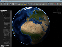
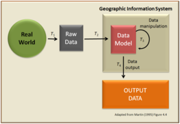
Geographic information systems (GIS) deal with storing information about the Earth for automatic retrieval by a computer in an accurate manner appropriate to the information's purpose.[75]In addition to all of the other subdisciplines of geography, GIS specialists must understandcomputer scienceanddatabasesystems. GIS has revolutionized the field of cartography: nearly all mapmaking is now done with the assistance of some form ofGIS software.The science of using GIS software and GIS techniques to represent, analyse, and predict the spatial relationships is calledgeographic information science(GISc).[76]
Remote sensing

Remote sensing is the art, science, and technology of obtaining information about Earth's features from measurements made at a distance.[77]Remotely sensed data can be either passive, such as traditionalphotography,or active, such asLiDAR.[77]A variety of platforms can be used for remote sensing, includingsatellite imagery,aerial photography(including consumer drones), and data obtained from hand-held sensors.[77]Products from remote sensing includeDigital elevation modeland cartographic base maps. Geographers increasingly use remotely sensed data to obtain information about the Earth'sland surface,ocean, and atmosphere, because it: (a) supplies objective information at a variety of spatial scales (local to global), (b) provides a synoptic view of the area of interest, (c) allows access to distant and inaccessible sites, (d) provides spectral information outside the visible portion of theelectromagnetic spectrum,and (e) facilitates studies of how features/areas change over time. Remotely sensed data may be analyzed independently or in conjunction with other digital data layers (e.g., in a geographic information system). Remote sensing aids in land use, land cover (LULC) mapping, by helping to determine both what is naturally occurring on a piece of land and what human activities are taking place on it.[78]
Geostatistics
Geostatisticsdeal withquantitative dataanalysis, specifically the application of a statistical methodology to the exploration of geographic phenomena.[79]Geostatistics is used extensively in a variety of fields, includinghydrology,geology, petroleum exploration, weather analysis,urban planning,logistics, andepidemiology.The mathematical basis for geostatistics derives fromcluster analysis,linear discriminant analysisandnon-parametric statistical tests,and a variety of other subjects. Applications of geostatistics rely heavily ongeographic information systems,particularly for theinterpolation(estimate) of unmeasured points. Geographers are making notable contributions to the method of quantitative techniques.
Qualitative methods
Qualitative methods in geography are descriptive rather than numerical or statistical in nature.[80][16][47]They add context to concepts, and explore human concepts like beliefs and perspective that are difficult or impossible to quantify.[16]Human geography is much more likely to employ qualitative methods than physical geography. Increasingly, technical geographers are attempting to employ GIS methods to qualitative datasets.[16][81]
Qualitative cartography

Qualitative cartography employs many of the same software and techniques as quantitative cartography.[81]It may be employed to inform on map practices, or to visualize perspectives and ideas that are not strictly quantitative in nature.[81][16]An example of a form of qualitative cartography is aChorochromatic mapof nominal data, such as land cover or dominant language group in an area.[82]Another example is adeep map,or maps that combine geography and storytelling to produce a product with greater information than a two-dimensional image of places, names, and topography.[83][84]This approach offers more inclusive strategies than more traditional cartographic approaches for connecting the complex layers that makeup places.[84]
Ethnography
Ethnographical research techniques are used by human geographers.[85]Incultural geography,there is a tradition of employingqualitative researchtechniques, also used inanthropologyand sociology.Participant observationand in-depth interviews provide human geographers with qualitative data.
Geopoetics
Geopoetics is an interdisciplinary approach that combines geography andpoetryto explore the interconnectedness between humans, space, place, and the environment.[86][87]Geopoetics is employed as amixed methodstool to explain the implications of geographic research.[88]It is often employed to address and communicate the implications of complex topics, such as theanthropocene.[89][90][91][92][93]
Interviews
Geographers employ interviews to gather data and acquire valuable understandings from individuals or groups regarding their encounters, outlooks, and opinions concerning spatial phenomena.[94][95]Interviews can be carried out through various mediums, including face-to-face interactions, phone conversations, online platforms, or written exchanges.[47]Geographers typically adopt a structured or semi-structured approach during interviews involving specific questions or discussion points when utilized for research purposes.[94]These questions are designed to extract focused information about the research topic while being flexible enough to allow participants to express their experiences and viewpoints, such as through open-ended questions.[94]
Origin
The concept of geography is present in all cultures, and therefore the history of the discipline is a series of competing narratives, with concepts emerging at various points across space and time.[96]The oldest knownworld mapsdate back toancient Babylonfrom the 9th century BC.[97]The best knownBabylonianworld map, however, is theImago Mundiof 600 BC.[98]The map as reconstructed byEckhard UngershowsBabylonon theEuphrates,surrounded by a circular landmass showingAssyria,Urartu,and several cities, in turn surrounded by a "bitter river" (Oceanus), with seven islands arranged around it so as to form a seven-pointed star.[99]The accompanying text mentions seven outer regions beyond the encircling ocean. The descriptions of five of them have survived.[100]In contrast to theImago Mundi,an earlier Babylonianworld mapdating back to the 9th century BC depicted Babylon as being further north from the center of the world, though it is not certain what that center was supposed to represent.[97]

The ideas ofAnaximander(c. 610–545 BC): considered by later Greek writers to be the true founder of geography, come to us through fragments quoted by his successors.[101]Anaximander is credited with the invention of thegnomon,the simple, yet efficient Greek instrument that allowed the early measurement oflatitude.[101]Thalesis also credited with the prediction of eclipses. The foundations of geography can be traced to ancient cultures, such as the ancient, medieval, and early modernChinese.TheGreeks,who were the first to explore geography as both art and science, achieved this throughCartography,Philosophy,andLiterature,or throughMathematics.There is some debate about who was the first person to assert that theEarth is sphericalin shape, with the credit going either toParmenidesorPythagoras.Anaxagoraswas able to demonstrate that the profile of the Earth was circular by explainingeclipses.However, he still believed that the Earth was a flat disk, as did many of his contemporaries. One of the first estimates of the radius of the Earth was made byEratosthenes.[102]
The first rigorous system oflatitude and longitudelines is credited toHipparchus.He employed asexagesimalsystem that was derived fromBabylonian mathematics.The meridians were subdivided into 360°, with each degree further subdivided into 60 (minutes). To measure the longitude at different locations on Earth, he suggested using eclipses to determine the relative difference in time.[103]The extensive mapping by theRomansas they explored new lands would later provide a high level of information forPtolemyto construct detailedatlases.He extended the work ofHipparchus,using a grid system on his maps and adopting a length of 56.5 miles for a degree.[104]
From the 3rd century onwards,Chinesemethods of geographical study and writing of geographical literature became much more comprehensive than what was found in Europe at the time (until the 13th century).[105]Chinese geographers such asLiu An,Pei Xiu,Jia Dan,Shen Kuo,Fan Chengda,Zhou Daguan,andXu Xiakewrote important treatises, yet by the 17th century advanced ideas and methods of Western-style geography were adopted in China.

During theMiddle Ages,thefall of the Roman empireled to a shift in the evolution of geography from Europe to theIslamic world.[105]Muslim geographerssuch asMuhammad al-Idrisiproduced detailed world maps (such asTabula Rogeriana), while other geographers such asYaqut al-Hamawi,Abu Rayhan Biruni,Ibn Battuta,andIbn Khaldunprovided detailed accounts of their journeys and the geography of the regions they visited. Turkish geographerMahmud al-Kashgaridrew a world map on a linguistic basis, and later so didPiri Reis(Piri Reis map). Further, Islamic scholars translated andinterpretedthe earlier works of theRomansand theGreeksand established theHouse of WisdominBaghdadfor this purpose.[106]Abū Zayd al-Balkhī,originally fromBalkh,founded the "Balkhī school" of terrestrial mapping inBaghdad.[107]Suhrāb, a late tenth century Muslim geographer accompanied a book of geographical coordinates, with instructions for making a rectangular world map withequirectangular projectionor cylindrical equidistant projection.[108]
Abu Rayhan Biruni(976–1048) first described a polar equi-azimuthal equidistant projectionof thecelestial sphere.[109]He was regarded as the most skilled when it came to mapping cities and measuring the distances between them, which he did for many cities in the Middle East and theIndian subcontinent.He often combined astronomical readings and mathematical equations to develop methods of pin-pointing locations by recording degrees oflatitudeandlongitude.He also developed similar techniques when it came to measuring the heights of mountains, depths of thevalleys,and expanse of thehorizon.He also discussedhuman geographyand theplanetary habitabilityof the Earth. He also calculated thelatitudeof Kath,Khwarezm,using the maximum altitude of the Sun, and solved a complexgeodesicequation to accurately compute theEarth's circumference,which was close to modern values of the Earth's circumference.[110]His estimate of 6,339.9 km for theEarth radiuswas only 16.8 km less than the modern value of 6,356.7 km. In contrast to his predecessors, who measured the Earth's circumference by sighting the Sun simultaneously from two different locations,al-Birunideveloped a new method of usingtrigonometriccalculations based on the angle between aplainand mountain top, which yielded more accurate measurements of the Earth's circumference, and made it possible for it to be measured by a single person from a single location.[111]

The EuropeanAge of Discoveryduring the 16th and the 17th centuries, where many new lands were discovered and accounts by European explorers such asChristopher Columbus,Marco Polo,andJames Cookrevived a desire for both accurate geographic detail and more solid theoretical foundations in Europe. In 1650, the first edition of theGeographia Generaliswas published byBernhardus Varenius,which was later edited and republished by others includingIsaac Newton.[112][113]This textbook sought to integrate new scientific discoveries and principles into classical geography and approach the discipline like the other sciences emerging, and is seen by some as the division between ancient and modern geography in the West.[112][113]
TheGeographia Generaliscontained both theoretical background and practical applications related to ship navigation.[113]The remaining problem facing both explorers and geographers was finding the latitude and longitude of a geographic location. While the problem of latitude was solved long ago, but that of longitude remained; agreeing on what zero meridians should be was only part of the problem. It was left toJohn Harrisonto solve it by inventing the chronometerH-4in 1760, and later in 1884 for theInternational Meridian Conferenceto adopt by convention theGreenwich meridianas zero meridians.[110]
The 18th and 19th centuries were the times when geography became recognized as a discreteacademic discipline,and became part of a typical university curriculum in Europe (especially Paris andBerlin). The development of many geographic societies also occurred during the 19th century, with the foundations of theSociété de Géographiein 1821, theRoyal Geographical Societyin 1830,Russian Geographical Societyin 1845,American Geographical Societyin 1851, and theNational Geographic Societyin 1888. The influence ofImmanuel Kant,Alexander von Humboldt,Carl Ritter,andPaul Vidal de la Blachecan be seen as a major turning point in geography from philosophy to an academic subject.[114][115][116][117][118]

Over the past two centuries, the advancements in technology with computers have led to the development ofgeomaticsand new practices such as participant observation and geostatistics being incorporated into geography's portfolio of tools. In the West during the 20th century, the discipline of geography went through four major phases:environmental determinism,regional geography,thequantitative revolution,andcritical geography.The strong interdisciplinary links between geography and the sciences of geology andbotany,as well as economics, sociology, anddemographics,have also grown greatly, especially as a result ofearth system sciencethat seeks to understand the world in a holistic view. New concepts and philosophies have emerged from the rapid advancement of computers, quantitative methods, and interdisciplinary approaches. In 1970,Waldo Toblerproposed thefirst law of geography,"everything is related to everything else, but near things are more related than distant things."[36][37]This law summarizes the first assumption geographers make about the world.
Notable geographers


- Alexander von Humboldt(1769–1859) – publishedCosmosand founder of the sub-field biogeography.
- Anne Kelly Knowles(Born 1957) – influential in the use of GIS and geographic methods in History.
- Bernhardus Varenius(1622–1650)– German geographer and author ofGeographia Generalis
- Carl O. Sauer(1889–1975) – cultural geographer.
- Carl Ritter(1779–1859) – occupied the first chair of geography at Berlin University.
- Cynthia Brewer– cartographic theorist that created the web applicationColorBrewer.
- Dana Tomlin– originator of map algebra
- Doreen Massey(1944–2016) – scholar in the space and places ofglobalizationand its pluralities; winner of theVautrin Lud Prize.
- Ellen Churchill Semple(1863–1932) – first female president of theAssociation of American Geographers.
- Eratosthenes(c.276–c. 195/194 BC) – calculated the size of the Earth.
- Ernest Burgess(1886–1966) – creator of theconcentric zone model.
- George F. Jenks(1916–1996) – influential in computer cartography and thematic mapping
- Gerardus Mercator(1512–1594) –cartographerwho produced themercator projection
- Mark Monmonier(born 1943) – cartographic theorist who wrote numerous books contributing to Geographic Information Systems.
- Mei-Po Kwan(born 1962) – contributed significantly to the use of GPS and real-time mapping within GIS
- Michael Frank Goodchild(born 1944) – GIScience scholar and winner of the RGS founder's medal in 2003.
- Muhammad al-Idrisi(Arabic: أبو عبد الله محمد الإدريسي; Latin: Dreses) (1100–1165) – author of Nuzhatul Mushtaq.
- Nigel Thrift(born 1949) – originator ofnon-representational theory.
- Paul Vidal de La Blache(1845–1918) – founder of the French school of geopolitics, wrote the principles of human geography.
- Ptolemy(c. 100–c. 170) – compiled Greek and Roman knowledge into the bookGeographia.
- Roger Tomlinson(1933 – 2014) – the primary originator of moderngeographic information systems.
- SirHalford Mackinder(1861–1947) – co-founder of theLSE,Geographical Association.
- Strabo(64/63 BC – c. AD 24) – wroteGeographica,one of the first books outlining the study of geography.
- Waldo Tobler(1930–2018) – coined thefirst law of geographyandsecond law of geography.
- Walter Christaller(1893–1969) – human geographer and inventor ofCentral place theory.
- William Morris Davis(1850–1934) – father of American geography and developer of thecycle of erosion.
- Yi-Fu Tuan(1930–2022) – Chinese-American scholar credited with starting Humanistic Geography as a discipline.
Institutions and societies
- American Association of Geographers(AAG)[119]
- American Geographical Society(US)[120]
- Anton Melik Geographical Institute(Slovenia)
- Gamma Theta Upsilon(international)
- Institute of Geographical Information Systems(Pakistan)
- International Geographical Union(International)
- National Council for Geographic Education(United States)
- National Geographic Society(United States)[121]
- Royal Canadian Geographical Society(Canada)
- Royal Danish Geographical Society(Denmark)
- Royal Geographical Society(UK)[122]
- Russian Geographical Society(Russia)
Publications
- Annals of the American Association of Geographers
- Antipode
- Applied Geography
- Concepts and Techniques in Modern Geography
- Dialogues in Human Geography
- Economic Geography
- Geographia Technica
- Geographical Review
- Geographical Bulletin
- GeoHumanities
- International Journal of Geographical Information Science
- ISPRS International Journal of Geo-Information
- Journal of Maps
- Journal of Rural Studies
- Journal of Transport Geography
- National Geographic
- Professional Geographer
- Progress in Human Geography
- The Geographical Journal
- The Professional Geographer
Related fields
Geology

The discipline of geography, especially physical geography, and geology have significant overlap. In the past, the two have often shared academic departments at universities, a point that has led to conflict over resources.[123]Both disciplines do seek to understand therockson the Earth's surface and the processes that change them over time. Geology employs many of the tools and techniques of technical geographers, such as GIS and remote sensing to aid ingeological mapping.[124]However, geology includes research that goes beyond the spatial component, such as the chemical analysis of rocks andbiogeochemistry.[125]
History
The discipline of History has significant overlap with geography, especially human geography.[126][127]Like geology, history and geography have shared university departments. Geography provides the spatial context within which historical events unfold.[126]The physical geographic features of a region, such as its landforms, climate, and resources, shape human settlements, trade routes, and economic activities, which in turn influence the course of historical events.[126]Thus, a historian must have a strong foundation in geography.[126][127]Historians employ the techniques of technical geographers to createhistorical atlasesand maps.
Planetary science

While the discipline of geography is normally concerned with the Earth, the term can also be informally used to describe the study of other worlds, such as theplanetsof theSolar Systemand even beyond. The study of systems larger than the Earth itself usually forms part ofAstronomyorCosmology.The study of other planets is usually calledplanetary science.Alternative terms such asareography (geography of Mars)have been employed to describe the study of other celestial objects. Ultimately, geography may be considered a subdiscipline within planetary science.
See also
- Earth analog– Planet with environment similar to Earth's
- Geologic time scale– System that relates geologic strata to time
- Geophysics– Physics of the Earth and its vicinity
- History of Earth– Development of planet Earth from its formation to the present day
- Terrestrial planet– Planet that is composed primarily of silicate rocks or metals
- Theoretical planetology– Scientific modeling of planets
Notes
- ^Emphasis added.
References
- ^abcDahlman, Carl; Renwick, William (2014).Introduction to Geography: People, Places & Environment(6th ed.). Pearson.ISBN978-0137504510.
- ^abBurt, Tim (2009).Key Concepts in Geography: Scale, Resolution, Analysis, and Synthesis in Physical Geography(2nd ed.). John Wiley & Sons. pp. 85–96.ISBN978-1-4051-9146-3.
- ^abcdefgSala, Maria (2009).Geography Volume I.Oxford, United Kingdom:EOLSSUNESCO.ISBN978-1-84826-960-6.
- ^Roller, Duane W. (2010).Eratosthenes' Geography.New Jersey: Princeton University Press.ISBN9780691142678.Retrieved29 January2024.
- ^Brentjes, Sonja (2009)."Cartography in Islamic Societies".International Encyclopedia of Human Geography.Elsevier. pp. 414–427.ISBN978-0-08-044911-1.Retrieved29 January2024.
- ^Kurt A. Raaflaub & Richard J. A. Talbert (2009).Geography and Ethnography: Perceptions of the World in Pre-Modern Societies.John Wiley & Sons.p. 147.ISBN978-1-4051-9146-3.
- ^abcdThrift, Nigel (2009).Key Concepts in Geography: Space, The Fundamental Stuff of Geography(2nd ed.). John Wiley & Sons. pp. 85–96.ISBN978-1-4051-9146-3.
- ^abKent, Martin (2009).Key Concepts in Geography: Space, Making Room for Space in Physical Geography(2nd ed.). John Wiley & Sons. pp. 97–119.ISBN978-1-4051-9146-3.
- ^abcdeTuan, Yi-Fu (1977).Space and Place: The Perspective of Experience.University of Minnesota Press.ISBN0-8166-3877-2.
- ^abcdTuan, Yi-Fu (1991)."A View of Geography".Geographical Review.81(1): 99–107.Bibcode:1991GeoRv..81...99T.doi:10.2307/215179.JSTOR215179.Retrieved5 January2023.
- ^abcdCastree, Noel (2009).Key Concepts in Geography: Place, Connections and Boundaries in an Interdependent World(2nd ed.). John Wiley & Sons. pp. 85–96.ISBN978-1-4051-9146-3.
- ^abcdGregory, Ken (2009).Key Concepts in Geography: Place, The Management of Sustainable Physical Environments(2nd ed.). John Wiley & Sons. pp. 173–199.ISBN978-1-4051-9146-3.
- ^abcdefPattison, William (1964)."The Four Traditions of Geography".Journal of Geography.63(5): 211–216.Bibcode:1964JGeog..63..211P.doi:10.1080/00221346408985265.Retrieved27 August2022.
- ^abcTambassi, Timothy (2021).The Philosophy of Geo-Ontologies(2nd ed.). Springer.ISBN978-3-030-78144-6.
- ^abcFotheringham, A. Stewart; Brunsdon, Chris; Charlton, Martin (2000).Quantitative Geography: Perspectives on Spatial Data Analysis.Sage Publications Ltd.ISBN978-0-7619-5948-9.
- ^abcdeBurns, Ryan; Skupin, Andre´ (2013)."Towards Qualitative Geovisual Analytics: A Case Study Involving Places, People, and Mediated Experience".Cartographica: The International Journal for Geographic Information and Geovisualization.48(3): 157–176.doi:10.3138/carto.48.3.1691.S2CID3269642.Retrieved17 December2022.
- ^Diriwächter, R. & Valsiner, J. (January 2006)Qualitative Developmental Research Methods in Their Historical and Epistemological Contexts.FQS. Vol 7, No. 1, Art. 8
- ^"Areography".Merriam-Webster.Retrieved27 July2022.
- ^Lowell, Percival (April 1902)."Areography".Proceedings of the American Philosophical Society.41(170): 225–234.JSTOR983554.Retrieved27 July2022.
- ^Sheehan, William (19 September 2014). "Geography of Mars, or Areography".Camille Flammarion's the Planet Mars.Astrophysics and Space Science Library. Vol. 409. pp. 435–441.doi:10.1007/978-3-319-09641-4_7.ISBN978-3-319-09640-7.
- ^abHayes-Bohanan, James (29 September 2009)."What is Environmental Geography, Anyway?".webhost.bridgew.edu.Bridgewater State University.Archivedfrom the original on 26 October 2006.Retrieved10 November2016.
- ^Hornby, William F.; Jones, Melvyn (29 June 1991).An introduction to Settlement Geography.Cambridge University Press.ISBN978-0-521-28263-5.Archivedfrom the original on 25 December 2016.
- ^Hughes, William. (1863).The Study of Geography.Lecture delivered at King's College, London, by Sir Marc Alexander. Quoted inBaker, J.N.L (1963).The History of Geography.Oxford: Basil Blackwell. p. 66.ISBN978-0-85328-022-4.
- ^abHough, Carole; Izdebska, Daria (2016). "Names and Geography". In Gammeltoft, Peder (ed.).The Oxford Handbook of Names and Naming.Oxford, United Kingdom: Oxford University Press.ISBN978-0-19-965643-1.
- ^Cotterill, Peter D. (1997)."What is geography?".AAG Career Guide: Jobs in Geography and related Geographical Sciences.American Association of Geographers. Archived fromthe originalon 6 October 2006.Retrieved9 October2006.
- ^abcdeHaidu, Ionel (2016)."What is Technical Geography"(PDF).Geographia Technica.11(1): 1–5.doi:10.21163/GT_2016.111.01.Archived(PDF)from the original on 19 January 2022.Retrieved22 July2022.
- ^abClifford, Nicholas J.; Holloway, Sarah L.; Rice, Stephen P.; Valentine, Gill, eds. (2014).Key Concepts in Geography(2nd ed.). Sage.ISBN978-1-4129-3022-2.Retrieved2 December2023.
- ^Holloway, Sarah L.; Rice, Stephen P.; Valentine, Gill, eds. (2003).Key Concepts in Geography(1st ed.). Sage.ISBN978-0761973898.
- ^Guidelines for Geographic Education: Elementary and Secondary Schools.The Council. 1984.ISBN9780892911851.
- ^abcNatoli, Salvatore J. (1 January 1994)."Guidelines for Geographic Educationand the Fundamental Themes in Geography ".Journal of Geography.93(1): 2–6.Bibcode:1994JGeog..93....2N.doi:10.1080/00221349408979676.ISSN0022-1341.
- ^abBuchanan, Lisa Brown; Tschida, Christina M. (2015)."Exploring the five themes of geography using technology".The Ohio Social Studies Review.52(1): 29–39.
- ^ab"Chapter 3: Geography's Perspectives".Rediscovering Geography: New Relevance for Science and Society.Washington, DC: The National Academies Press. 1997. p. 28.doi:10.17226/4913.ISBN978-0-309-05199-6.Archivedfrom the original on 7 May 2014.Retrieved6 May2014.
- ^abcdeMatthews, John; Herbert, David (2008).Geography: A very short introduction.Oxford University Press.ISBN978-0-19-921128-9.
- ^abChen, Xiang; Clark, Jill (2013)."Interactive three-dimensional geovisualization of space-time access to food".Applied Geography.43:81–86.Bibcode:2013AppGe..43...81C.doi:10.1016/j.apgeog.2013.05.012.Retrieved7 December2022.
- ^Tuan, Yi-Fu (1991). "Language and the Making of Place: A Narrative-Descriptive Approach".Annals of the Association of American Geographers.81(4): 684–696.doi:10.1111/j.1467-8306.1991.tb01715.x.
- ^abcdefTobler, Waldo (1970)."A Computer Movie Simulating Urban Growth in the Detroit Region"(PDF).Economic Geography.46:234–240.doi:10.2307/143141.JSTOR143141.S2CID34085823.Archived fromthe original(PDF)on 8 March 2019.Retrieved22 July2022.
- ^abcTobler, Waldo (2004)."On the First Law of Geography: A Reply".Annals of the Association of American Geographers.94(2): 304–310.doi:10.1111/j.1467-8306.2004.09402009.x.S2CID33201684.Archivedfrom the original on 21 June 2022.Retrieved22 July2022.
- ^abThrift, Nigel (1977).An Introduction to Time-Geography.Geo Abstracts, University of East Anglia.ISBN0-90224667-4.
- ^Thornes, John (2009).Key Concepts in Geography: Time, Change and Stability in Environmental Systems(2nd ed.). John Wiley & Sons. pp. 119–139.ISBN978-1-4051-9146-3.
- ^Taylor, Peter (2009).Key Concepts in Geography: Time, From Hegemonic Change to Everyday life(2nd ed.). John Wiley & Sons. pp. 140–152.ISBN978-1-4051-9146-3.
- ^Galison, Peter Louis (1979). "Minkowski's space–time: From visual thinking to the absolute world".Historical Studies in the Physical Sciences.10:85–121.doi:10.2307/27757388.JSTOR27757388.
- ^abMiller, Harvey (2017)."Time geography and space–time prism".International Encyclopedia of Geography: People, the Earth, Environment and Technology:1–19.doi:10.1002/9781118786352.wbieg0431.ISBN978-0470659632.Retrieved1 September2022.
- ^Monmonier, Mark (1990)."Strategies For The Visualization Of Geographic Time-Series Data".Cartographica.27(1): 30–45.doi:10.3138/U558-H737-6577-8U31.Retrieved1 September2022.
- ^abHerod, Andrew (2009).Key Concepts in Geography: Scale, the local and the global(2nd ed.). John Wiley & Sons. pp. 85–96.ISBN978-1-4051-9146-3.
- ^abArbia, Giuseppe; Benedetti, R.; Espa, G. (1996). ""Effects of MAUP on image classification"".Journal of Geographical Systems.3:123–141.
- ^abSmith, Peter (2005)."The laws of geography".Teaching Geography.30(3): 150.JSTOR23756334.
- ^abcDeLyser, Dydia; Herbert, Steve; Aitken, Stuart; Crang, Mike; McDowell, Linda (November 2009).The SAGE Handbook of Qualitative Geography(1 ed.). SAGE Publications.ISBN9781412919913.Retrieved27 April2023.
- ^Yano, Keiji (2001). "GIS and quantitative geography".GeoJournal.52(3): 173–180.doi:10.1023/A:1014252827646.S2CID126943446.
- ^abcWalker, Robert Toovey (28 April 2021). "Geography, Von Thünen, and Tobler's first law: Tracing the evolution of a concept".Geographical Review.112(4): 591–607.doi:10.1080/00167428.2021.1906670.S2CID233620037.
- ^abcdeTobler, Waldo (2004)."On the First Law of Geography: A Reply".Annals of the Association of American Geographers.94(2): 304–310.doi:10.1111/j.1467-8306.2004.09402009.x.S2CID33201684.Retrieved10 March2022.
- ^abcdefGoodchild, Michael (2004). "The Validity and Usefulness of Laws in Geographic Information Science and Geography".Annals of the Association of American Geographers.94(2): 300–303.doi:10.1111/j.1467-8306.2004.09402008.x.S2CID17912938.
- ^Tobler, Waldo (1999). "Linear pycnophylactic reallocation comment on a paper by D. Martin".International Journal of Geographical Information Science.13(1): 85–90.Bibcode:1999IJGIS..13...85T.doi:10.1080/136588199241472.
- ^Hecht, Brent; Moxley, Emily (2009). "Terabytes of Tobler: Evaluating the First Law in a Massive, Domain-Neutral Representation of World Knowledge".Spatial Information Theory.Lecture Notes in Computer Science. Vol. 5756. Springer. p. 88.Bibcode:2009LNCS.5756...88H.doi:10.1007/978-3-642-03832-7_6.ISBN978-3-642-03831-0.
- ^Otto, Philipp; Dogan, Osman; Taspınar, Suleyman (2023). "A Dynamic Spatiotemporal Stochastic Volatility Model with an Application to Environmental Risks".Econometrics and Statistics.arXiv:2211.03178.doi:10.1016/j.ecosta.2023.11.002.S2CID253384426.
- ^Zou, Muquan; Wang, Lizhen; Wu, Ping; Tran, Vanha (23 July 2022)."Mining Type-β Co-Location Patterns on Closeness Centrality in Spatial Data Sets".ISPRS Int. J. Geo-Inf.11(8): 418.Bibcode:2022IJGI...11..418Z.doi:10.3390/ijgi11080418.
- ^Zhang, Yu; Sheng, Wu; Zhao, Zhiyuan; Yang, Xiping; Fang, Zhixiang (30 January 2023)."An urban crowd flow model integrating geographic characteristics".Scientific Reports.13(1): 1695.Bibcode:2023NatSR..13.1695Z.doi:10.1038/s41598-023-29000-5.PMC9886992.PMID36717687.
- ^abcCave, Edward (1749).Geography reformed: a new system of general geography, according to an accurate analysis of the science in four parts. The whole illustrated with notes(2nd ed.). London: Edward Cave.
- ^abcRobinson, J. Lewis (1976)."A New Look at the Four Traditions of Geography".Journal of Geography.75(9): 520–530.Bibcode:1976JGeog..75..520R.doi:10.1080/00221347608980845.Retrieved27 August2022.
- ^abcMurphy, Alexander (27 June 2014)."Geography's Crosscutting Themes: Golden Anniversary Reflections on" The Four Traditions of Geography "".Journal of Geography.113(5): 181–188.Bibcode:2014JGeog.113..181M.doi:10.1080/00221341.2014.918639.S2CID143168559.Retrieved27 August2022.
- ^abcdSala, Maria (2009).Geography – Vol. I: Geography(PDF).EOLSSUNESCO.Retrieved30 December2022.
- ^abcDada, Anup (December 2022)."The Process of Geomorphology Related to Sub Branches of Physical Geography".Black Sea Journal of Scientific Research.59(3): 1–2.Retrieved9 May2023.
- ^abOrmeling, Ferjan (2009).Geography – Vol. II: Technical Geography Core concepts in the mapping sciences(PDF).EOLSSUNESCO. p. 482.ISBN978-1-84826-960-6.
- ^"1(b). Elements of Geography".www.physicalgeography.net.
- ^Pidwirny, Michael; Jones, Scott (1999–2015)."Physical Geography".
- ^Marsh, William M.; Kaufman, Martin M. (2013).Physical Geography: Great Systems and Global Environments.Cambridge University Press.ISBN978-0521764285.
- ^Lockyer, Norman (1900)."Physiography and Physical Geography".Nature.63(1626): 207–208.Bibcode:1900Natur..63..207R.doi:10.1038/063207a0.ISSN0028-0836.
- ^Johnston, Ron (2000). "Human Geography". In Johnston, Ron; Gregory, Derek; Pratt, Geraldine; et al. (eds.).The Dictionary of Human Geography.Oxford: Blackwell. pp. 353–360.
- ^Getis, Arthur; Bjelland, Mark; Getis, Victoria (2018).Introduction to Geography(15th ed.). McGraw Hill.ISBN978-1-259-57000-1.
- ^Fundamentals of Physical Geography as a Discipline.New Delhi: National Council of Educational Research and Training. 2006. pp. 1–12.ISBN81-7450-518-0.
- ^Lake, Ron; Burggraf, David; Trninic, Milan; Rae, Laurie (2004).Geography Mark-Up Language: Foundation for the Geo-Web.John Wiley and Sons Inc.ISBN0-470-87154-7.
- ^Kretzschmar Jr., William A. (24 October 2013). Schlüter, Julia; Krug, Manfred (eds.).Research Methods in Language Variation and Change: Computer mapping of language data.Cambridge University Press. p. 53.ISBN9781107469846.
- ^Gregory, Derek; Johnston, Ron; Pratt, Geraldine; Watts, Michael J.; Whatmore, Sarah (2009).The Dictionary of Human Geography(5th ed.). US & UK: Wiley-Blackwell. pp. 611–612.
- ^Kainz, Wolfgang (21 October 2019)."Cartography and the others – aspects of a complicated relationship".Geo-spatial Information Science.23(1): 52–60.doi:10.1080/10095020.2020.1718000.S2CID214162170.
- ^Jenks, George (December 1953). "An Improved Curriculum for Cartographic Training at the College and University Level".Annals of the Association of American Geographers.43(2): 317–331.doi:10.2307/2560899.JSTOR2560899.
- ^DeMers, Michael (2009).Fundamentals of Geographic Information Systems(4th ed.). John Wiley & Sons, inc.ISBN978-0-470-12906-7.
- ^Monmonier, Mark (1985).Technological Transition in Cartography.Univ of Wisconsin Pr.ISBN978-0299100704.
- ^abcJensen, John (2016).Introductory digital image processing: a remote sensing perspective.Glenview, IL: Pearson Education, Inc. p. 623.ISBN978-0-13-405816-0.
- ^Zhang, Chuanrong; Li, Xinba (September 2022)."Land Use and Land Cover Mapping in the Era of Big Data".Land.11(10): 1692.doi:10.3390/land11101692.
- ^Krige, Danie G. (1951). "A statistical approach to some basic mine valuation problems on the Witwatersrand". J. of the Chem., Metal. and Mining Soc. of South Africa 52 (6): 119–139
- ^Vibha, Pathak; Bijayini, Jena; Sanjay, Kaira (2013)."Qualitative research".Perspect Clin Res.4(3): 192.doi:10.4103/2229-3485.115389.PMC3757586.PMID24010063.
- ^abcSuchan, Trudy; Brewer, Cynthia (2000)."Qualitative Methods for Research on Mapmaking and Map Use".The Professional Geographer.52(1): 145–154.Bibcode:2000ProfG..52..145S.doi:10.1111/0033-0124.00212.S2CID129100721.Retrieved26 August2022.
- ^Brewer, Cynthia (1994). "Color use guidelines for mapping and visualization". In MacEachren, A.M.; Taylor, D.R. Fraser (eds.).Visualization in Modern Cartography.Elsevier. pp. 123–134.ISBN1483287920.Retrieved24 December2023.
- ^Bodenhamer, David J.; John Corrigan; Trevor M. Harris. 2015.Deep Maps and Spatial Narratives.Indiana University Press. DOI: 10.2307/j.ctt1zxxzr2
- ^abButts, Shannon; Jones, Madison (20 May 2021)."Deep mapping for environmental communication design".Communication Design Quarterly.9(1): 4–19.doi:10.1145/3437000.3437001.S2CID234794773.
- ^Cook, Ian; Crang, Phil (1995).Doing Ethnographies.
- ^Magrane, Eric (2015)."Situating Geopoetics".GeoHumanities.1(1): 86–102.doi:10.1080/2373566X.2015.1071674.S2CID219396902.Retrieved21 August2022.
- ^Magrane, Eric; Russo, Linda; de Leeuw, Sarah; Santos Perez, Craig (2019).Geopoetics in Practice(1 ed.). London: Taylor & Francis.doi:10.4324/9780429032202.ISBN9780367145385.S2CID203499214.Retrieved21 August2022.
- ^Magrane, Eric; Johnson, Maria (2017)."An art–science approach to bycatch in the Gulf of California shrimp trawling fishery".Cultural Geographies.24(3): 487–495.Bibcode:2017CuGeo..24..487M.doi:10.1177/1474474016684129.S2CID149158790.Retrieved21 August2022.
- ^Magrane, Eric (2021)."Climate geopoetics (the earth is a composted poem)".Dialogues in Human Geography.11(1): 8–22.doi:10.1177/2043820620908390.S2CID213112503.Retrieved22 August2022.
- ^Nassar, Aya (2021)."Geopoetics: Storytelling against mastery".Dialogues in Human Geography.1:27–30.doi:10.1177/2043820620986397.S2CID232162263.
- ^Engelmann, Sasha (2021)."Geopoetics: On organising, mourning, and the incalculable".Dialogues in Human Geography.11:31–35.doi:10.1177/2043820620986398.S2CID232162320.Retrieved22 August2022.
- ^Acker, Maleea (2021)."Gesturing toward the common and the desperation: Climate geopoetics' potential".Dialogues in Human Geography.11(1): 23–26.doi:10.1177/2043820620986396.S2CID232162312.Retrieved22 August2022.
- ^Cresswell, Tim (2021)."Beyond geopoetics: For hybrid texts".Dialogues in Human Geography.11:36–39.doi:10.1177/2043820620986399.hdl:20.500.11820/b64b3dd4-c959-4a8e-877f-85d3058ce4b1.S2CID232162314.
- ^abcDixon, C.; Leach, B. (1977).Questionnaires and Interviews in Geographical Research(PDF).Geo Abstracts.ISBN0-902246-97-6.
- ^Dixon, Chris; Leach, Bridget (1984).Survey Research in Underdeveloped Countries(PDF).ISBN0-86094-135-3.
- ^Heffernan, Mike (2009).Key Concepts in Geography: Histories of Geography(2nd ed.). Sage. pp. 3–20.ISBN978-1-4129-3022-2.
- ^abRaaflaub, Kurt A.; Talbert, Richard J.A. (2009).Geography and Ethnography: Perceptions of the World in Pre-Modern Societies.John Wiley & Sons.ISBN978-1-4051-9146-3.
- ^Siebold, Jim (1998)."Babylonian clay tablet, 600 B.C."henry-davis.com.Henry Davis Consulting Inc.Archivedfrom the original on 9 November 2016.Retrieved10 November2016.
- ^Delano Smith, Catherine (1996). "Imago Mundi's Logo the Babylonian Map of the World".Imago Mundi.48:209–211.doi:10.1080/03085699608592846.JSTOR1151277.
- ^Finkel, Irving (1995).A join to the map of the world: A notable discovery.British Museum Magazine.ISBN978-0-7141-2073-7.
- ^abKish, George (1978).A Source Book in Geography.Harvard University Press.ISBN978-0-674-82270-2.Archivedfrom the original on 24 April 2016.Retrieved17 May2020.
- ^Tassoul, Jean-Louis; Tassoul, Monique (2004).A Concise History of Solar and Stellar Physics.London:Princeton University Press.ISBN978-0-691-11711-9.
- ^Smith, Sir William (1846).Dictionary of Greek and Roman Biography and Mythology: Earinus-Nyx.Vol. 2nd. London: Taylor and Walton.Archivedfrom the original on 16 April 2021.Retrieved15 May2020.
- ^Sullivan, Dan (2000)."Mapmaking and its History".rutgers.edu.Rutgers University.Archivedfrom the original on 4 March 2016.Retrieved10 November2016.
- ^abNeedham, Joseph (1959).Mathematics and the Sciences of the Heavens and the Earth.Vol. 3. Taipei: Caves Books, Ltd.ISBN978-0-521-05801-8.Archivedfrom the original on 25 September 2016.
{{cite book}}:|work=ignored (help) - ^Nawwab, Ismail I.; Hoye, Paul F.; Speers, Peter C. (5 September 2018)."Islam and Islamic History and The Middle East".islamicity.com.Archivedfrom the original on 17 June 2016.Retrieved10 November2016.
- ^Edson, Evelyn;Savage-Smith, Emilie(2007). "Medieval Views of the Cosmos".International Journal of the Classical Tradition.13(3): 61–63.JSTOR30222166.
- ^Tibbetts, Gerald R. (1997). "The Beginnings of a Cartographic Tradition". InHarley, John Brian;Woodward, David(eds.).The history of cartography.Vol. 2. Chicago: Brill.ISBN0-226-31633-5.Archivedfrom the original on 12 May 2020.Retrieved15 May2020.
- ^King, David A. (1996). Rashed, Roshdi (ed.).Astronomy and Islamic society: Qibla, genomics and timekeeping(PDF).Vol. 1.ISBN978-0-203-71184-2.Archived(PDF)from the original on 11 November 2016.
{{cite book}}:|work=ignored (help) - ^abAber, James Sandusky (2003)."Abu Rayhan al-Biruni".academic.emporia.edu.Emporia State University.Archivedfrom the original on 11 August 2011.Retrieved10 November2016.
- ^Goodman, Lenn Evan (1992).Avicenna.Great Britain: Routledge.ISBN978-0-415-01929-3.Archivedfrom the original on 16 April 2021.Retrieved3 May2020.
It was Biruni, not Avicenna, who found a way for a single man, at a single moment, to measure the earth's circumference, by trigonometric calculations based on angles measured from a mountaintop and the plain beneath it – thus improving on Eratosthenes' method of sighting the sun simultaneously from two different sites, applied in the ninth century by astronomers of the Khalif al-Ma'mun.
- ^abBaker, J. N. L. (1955). "The Geography of Bernhard Varenius".Transactions and Papers (Institute of British Geographers).21(21): 51–60.doi:10.2307/621272.JSTOR621272.
- ^abcWarntz, William (1989)."Newton, the Newtonians, and the Geographia Generalis Varenii".Annals of the Association of American Geographers.79(2): 165–191.doi:10.2307/621272.JSTOR621272.Retrieved9 June2024.
- ^Société de Géographie (2016)."Société de Géographie, Paris, France"[Who are we? – Society of Geography].socgeo.com(in French). Société de Géographie.Archivedfrom the original on 6 November 2016.Retrieved10 November2016.
- ^"About Us".rgs.org.Royal Geographical Society.Archived fromthe originalon 18 October 2016.Retrieved10 November2016.
- ^"Русское Географическое Общество (основано в 1845 г.)"[Russian Geographical Society].rgo.ru(in Russian).Russian Geographical Society.Archived fromthe originalon 24 May 2012.Retrieved10 November2016.
- ^"History".amergeog.org.The American Geographical Society. Archived fromthe originalon 17 October 2016.Retrieved10 November2016.
- ^"National Geographic Society".state.gov.U.S. Department of State.Archivedfrom the original on 23 December 2019.Retrieved10 November2016.
- ^Freeman, T. W.; James, Preston E.; Martin, Geoffrey J. (July 1980)."The Association of American Geographers: The First Seventy-Five Years 1904–1979".The Geographical Journal.146(2): 298.Bibcode:1980GeogJ.146..298F.doi:10.2307/632894.ISSN0016-7398.JSTOR632894.
- ^"AGS History".26 February 2009. Archived fromthe originalon 26 February 2009.Retrieved11 October2021.
- ^"National Geographic Society".U.S. Department of State.Archivedfrom the original on 23 December 2019.Retrieved11 October2021.
- ^"Royal Geographical Society (with IBG)".www.rgs.org.Archivedfrom the original on 12 May 2020.Retrieved11 October2021.
- ^Smith, Neil (1987).""Academic War Over the Field of Geography": The Elimination of Geography at Harvard, 1947-1951 ".Annals of the Association of American Geographers.77(2): 155–172.doi:10.1111/j.1467-8306.1987.tb00151.x.JSTOR2562763.S2CID145064363.Retrieved18 May2023.
- ^Compton, Robert R. (1985).Geology in the field.New York: Wiley.ISBN978-0-471-82902-7.
- ^Gorham, Eville (1 January 1991)."Biogeochemistry: its origins and development".Biogeochemistry.13(3): 199–239.doi:10.1007/BF00002942.ISSN1573-515X.S2CID128563314.
- ^abcdBryce, James (1902). "The Importance of Geography in Education".The Geographical Journal.23(3): 29–32.doi:10.2307/1775737.JSTOR1775737.
- ^abDarby, Henry Clifford(2002).The Relations of History and Geography: Studies in England, France, and the United States.Exeter: University of Exeter Press. p. 14.ISBN978-0859896993.
External links
 Definitionsfrom Wiktionary
 Mediafrom Commons
 Newsfrom Wikinews
 Quotationsfrom Wikiquote
 Textsfrom Wikisource
 Textbooksfrom Wikibooks
 Resourcesfrom Wikiversity
 Datafrom Wikidata
- Geographyat theEncyclopaedia Britannicawebsite
- Definition of geography at Dictionary.com
- Definition of geography by Lexico
- Origin and meaning of geography by Online Etymology Dictionary
- Topic Dictionaries at Oxford Learner's Dictionaries
| Branches |
| ||||||||
|---|---|---|---|---|---|---|---|---|---|
| Techniques and tools |
| ||||||||
| Institutions | |||||||||
| Education | |||||||||
| Primary | |
|---|---|
| Interdisciplinary |
|
| List | |
| Other categorizations | |
| National | |
|---|---|
| Other | |