Nydeggstalden
Appearance
This articleneeds additional citations forverification.(January 2010) |
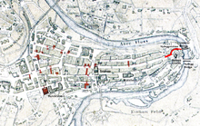
 Old City of Bern with Nydeggstalden highlighted | |
| Length | 100 m (330 ft) |
|---|---|
| Location | Old City of Bern,Bern,Switzerland |
| Postal code | 3011 |
| Coordinates | 46°56′57.6″N7°27′27.45″E/ 46.949333°N 7.4576250°E |
TheNydeggstaldenis one of the streets in theOld City of Bern,the medieval city center ofBern,Switzerland.It is part of theNydeggwhich was part of themedievalindustrial section of Bern. It is a semi-circular road running fromGerechtigkeitsgassetoward theAareriver and theUntertorbrücke(German: Lower Gate bridge). It is part of theUNESCOCulturalWorld Heritage Sitethat encompasses the Old City.
History
[edit]Originally Nydeggstalden was the eastern route from the Aare to Gerechtigkeitsgasse. In 1759 the road was smoothed and repaired. In 1956/58 theSchattseitigen(Shadow or southern side) of the street was rebuilt under the direction of H. Weiss.[1]
References
[edit]- ^Weber, Berchtold (1976).Historisch-topographisches Lexikon der Stadt Bern.Retrieved28 January2010.(in German)
