Nakaibito, New Mexico
Nakaibito, New Mexico | |
|---|---|
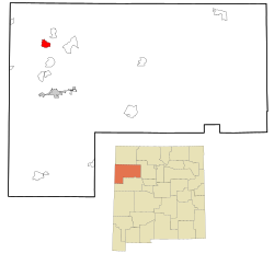
 Location of Nakaibito, New Mexico | |
| Coordinates:35°46′57″N108°48′28″W/ 35.78250°N 108.80778°W | |
| Country | United States |
| State | New Mexico |
| County | McKinley |
| Area | |
| • Total | 7.00 sq mi (18.12 km2) |
| • Land | 7.00 sq mi (18.12 km2) |
| • Water | 0.00 sq mi (0.00 km2) |
| Elevation | 6,378 ft (1,944 m) |
| Population | |
| • Total | 355 |
| • Density | 50.73/sq mi (19.59/km2) |
| Time zone | UTC-7(Mountain (MST)) |
| • Summer (DST) | UTC-6(MDT) |
| ZIP code | 87320[4] |
| Area code | 505 |
| FIPS code | 35-50860 |
| GNISfeature ID | 2408899[2] |
Nakaibito(Template:Lang-nv) (also known asMexican Springs)[5]is acensus-designated place(CDP) inMcKinley County,New Mexico,United States. The population was 455 at the2000 census.
Geography
According to theUnited States Census Bureau,the CDP has a total area of 6.9 square miles (18 km2), all land.
Demographics
| Census | Pop. | Note | %± |
|---|---|---|---|
| 2020 | 355 | — | |
| U.S. Decennial Census[6][3] | |||
As of thecensus[7]of 2000, there were 455 people, 117 households, and 91 families residing in the CDP. The population density was 66.2 inhabitants per square mile (25.6/km2). There were 150 housing units at an average density of 21.8 per square mile (8.4/km2). The racial makeup of the CDP was 99.12%Native American,0.44%White,0.22%Asian,and 0.22% fromother races.HispanicorLatinoof any race were 1.54% of the population.
There were 117 households, out of which 41.0% had children under the age of 18 living with them, 44.4% weremarried couplesliving together, 28.2% had a female householder with no husband present, and 21.4% were non-families. 17.1% of all households were made up of individuals, and 7.7% had someone living alone who was 65 years of age or older. The average household size was 3.89 and the average family size was 4.52.
In the CDP, the population was spread out, with 37.8% under the age of 18, 12.5% from 18 to 24, 27.5% from 25 to 44, 14.7% from 45 to 64, and 7.5% who were 65 years of age or older. The median age was 25 years. For every 100 females, there were 97.8 males. For every 100 females age 18 and over, there were 93.8 males.
The median income for a household in the CDP was $28,068, and the median income for a family was $28,977. Males had a median income of $21,786 versus $28,188 for females. Theper capita incomefor the CDP was $8,546. About 24.7% of families and 25.8% of the population were below thepoverty line,including 18.0% of those under age 18 and 45.7% of those age 65 or over.
Education
It is in theGallup-McKinley County Schoolsdistrict.[8]
Zoned schools are, all inTohatchi:Tohatchi Elementary School, Tohatchi Middle School, andTohatchi High School.[9]
Archaeology
Many archaeological investigations have been done in the general area of Nakaibito and the nearby community ofTohatchi.[10]
References
- ^"ArcGIS REST Services Directory".United States Census Bureau.RetrievedOctober 12,2022.
- ^abU.S. Geological Survey Geographic Names Information System: Nakaibito, New Mexico
- ^ab"Census Population API".United States Census Bureau.RetrievedOctober 12,2022.
- ^"Nakaibito ZIP Code".zipdatamaps.com. 2022.RetrievedNovember 11,2022.
- ^"Mexican Springs".Geographic Names Information System.United States Geological Survey,United States Department of the Interior.
- ^"Census of Population and Housing".Census.gov.RetrievedJune 4,2016.
- ^"U.S. Census website".United States Census Bureau.RetrievedJanuary 31,2008.
- ^"2020 CENSUS - SCHOOL DISTRICT REFERENCE MAP: McKinley County, NM"(PDF).U.S. Census Bureau.RetrievedJuly 20,2021.
- ^"GMCS Address Lookup".Gallup-McKinley County Schools.RetrievedJanuary 15,2022.- KML files:Elementary boundariesandlocations,Middle boundariesandlocations,andHigh boundariesandlocations.
- ^Damp, Jonathan (1999).Chuska chronologies, houses, and hogans: archaeological and ethnographic inquiry along N30-N31 between Mexican Springs and Navajo, McKinley County, New Mexico, Volume 1.Zuni, New Mexico: Zuni Cultural Resource Enterprise. p. 38.


