A5103 road
This articleneeds additional citations forverification.(July 2010) |
| A5103 | |
|---|---|
 | |
| Route information | |
| Maintained by National Highways Manchester City Council | |
| Length | 4.9 mi (7.9 km) |
| Major junctions | |
| North end | Manchester city centreandHulme |
| South end | M56 motorwayJunction 3A andWythenshawe |
| Location | |
| Country | United Kingdom |
| Primary destinations | Manchester |
| Road network | |
TheA5103is a majorroadinEngland.It runs fromPiccadilly GardensinManchester city centreto junction 3 of theM56 motorwayand is one of Manchester's principalradialroutes.
History
[edit]
The original scheme for a new road through the rural area south of Manchester was the design of theurban plannerRichard Barry Parker,who envisaged the creation of aparkway– a broad, landscaped highway – to run from the newgarden suburbofWythenshawe,connecting it withManchester City Centre.[1][2]Manchester Corporationbegan construction of the newPrincess Parkwayin 1929 with a new bridge over theRiver Mersey.[3]The new road was laid out as adual carriagewayfor motor vehicles with asegregated tram trackalong thecentral reservationforManchester Corporation Tramwaysto runtramsintoManchester City Centre.[4]
Princess Road/Princess Parkway was one of two newarterial roadsinto Manchester built by Manchester Corporation; the other wasKingsway,a few miles to the east, also built as a dual carriageway with reserved tram tracks along the middle. This layout was known as the 'Brodie' system, a new approach toroad designthat had been pioneered inLiverpoolbyJohn Alexander Brodie.[5][6][7]The first tracks were laid out in the 1920s, terminating atSouthern Cemetery;Manchester Corporation Transportplanned to extend the tracks toNorthendenand Wythenshawe, but following a change in transport policy in 1930, the Corporation invested in bus services instead.[3]Manchester Corporation Tramways eventually ceased operation in 1949 and the tram tracks were removed.[8]
Parker's scenic Parkway route, running south from Barlow Moor Road to Altrincham Road, was noted for its landscaped verges androse beds.In its 1945 plan, Manchester Corporation proposed extending the road northwards into the city centre and south throughOllertonandToft,creating a major traffic route into the city. In 1969, work began to upgrade Princess Parkway tomotorwaystandards, in order to feed into theM56 motorway.To enable this work, Parker's landscaping was removed, with 50,000 trees and shrubs being uprooted, and pedestrianfootbridgeswere installed, and an oldcountry house,Kenworthy Hall, was demolished.[9][10]
In 1997, theHulme Arch Bridgedesigned byChris Wilkinson ArchitectsandArupwas installed over Princess Road in theHulmearea.[11]
Route description
[edit]A6 to the Mancunian Way
[edit]This short section is entirely single-carriageway: it runs in roughly a north–south direction from the junction of theA6andA62alongPortland Street.It thenshares a short sectionwith theA34(Oxford Street) running west untilSt Peter's Square.After St Peter's Square, it proceeds south-west along LowerMosley Street,running past theManchester Central Convention Complex(formerlyManchester Central station), and theBridgewater Hall.It then turns south along Albion and Medlock Streets (crossing theRochdale Canal,the railway viaduct, and theRiver Medlock), where it meets theMancunian Wayat a roundabout.
Princess Road (A57(M) motorway to the M60 motorway)
[edit]This section is entirelydual carriagewayprimary routeleading in a southerly direction. The entire section is officially calledPrincess Road,but many locals refer to it asPrincess Parkway(see below). This section predominantly has a 30 mph (48 km/h) speed limit. Just before the M60 J5, the speed limit goes up to 40 mph.
The road runs throughHulme,Moss SideandWhalley Range,passingWilliam Hulme Grammar School,Whalley Range High SchoolandSouthern Cemeteryon the way.
This section has manytraffic lightcontrolled junctions, including major junctions with theA6010 Manchester middle ring roadandA5145 Barlow Moor Road.0.7 miles (1.1 km) south of its junction with the A5145, the road crosses theRiver Merseyand meets theM60 motorwayat a large free-flowinterchangeat junction 5. The speed limit also goes up to 40 mph.
Princess Parkway (M60 motorway to the M56 motorway)
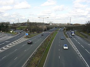
[edit]This section is entirelydual carriagewaytrunk road,and is an important link between theM60 Manchester Outer Ring roadand theM56 motorway.This section is calledPrincess Parkwayand largely has a 50 mph (80 km/h) speed limit. Between the M56 and M60, the road has two intermediate junctions; with the B5166 towardsNorthendenand Sale Moor, and with theA560leading toGatley,WythenshaweandBaguley.Between junctions, the A5103 here has four lanes in each direction with nohard shoulder.Between the on-and-offsliproadsof the junctions, it has 3 lanes in each direction with hard shoulder. At the southern end, at the A560 junction, the A5103 seamlessly becomes the mainline of the M56 heading towardsManchester Airport,Chesterand theM6 motorway.Northbound traffic on the M56 must leave the mainline of the motorway at a sliproad to remain on the M56. Remaining on the mainline leads directly to the A5103.
References
[edit]- ^Parkinson-Bailey, John J. (2000).Manchester: An Architectural History.Manchester University Press. p. 158.ISBN9780719056062.
- ^"Wythenshawe History".Your Wythenshawe.Archivedfrom the original on 29 June 2017.Retrieved29 June2017.
- ^abDeakin, Derick, ed. (1989).Wythenshawe, the story of a garden city.Chichester: Phillimore. pp. 49–65.ISBN9780850336993.
- ^Stratton, Michael; Trinder, Barrie (2014).Twentieth Century Industrial Archaeology.Taylor & Francis. p. 126.ISBN9781136748011.
- ^Crosby, Alan, ed. (1998).Leading the way: a history of Lancashire's roads.Preston: Lancashire County Books. p. 212.ISBN9781871236330.
- ^"Tramways".The Tramway Review.25.Light Railway Transport League.2003.
- ^Rowley, Trevor (2006).The English landscape in the twentieth century.Continuum International Publishing Group. p. 20.ISBN1-85285-388-3.
- ^"Greater Manchester Transport Timeline".Museum of Transport, Greater Manchester.Archived fromthe originalon 26 October 2015.Retrieved7 June2017.
- ^"Wythenshawe – Princess Parkway".Wythenshawe History Group.Archivedfrom the original on 29 June 2017.Retrieved29 June2017.
- ^Johnston, Mark (2015).Trees in Towns and Cities: A History of British Urban Arboriculture.Windgather Press. pp. 253–4.ISBN9781909686656.
- ^Collis, Hugh (2003).Transport, Engineering and Architecture.Gulf Professional Publishing.ISBN9780750677486.
External links
[edit]- Jukes, Steven."Princess Parkway Motorways".Pathetic Motorways.Archivedfrom the original on 29 June 2017.Retrieved29 June2017.
- Map of Manchester's trams in 1944

